We found 109182 price guide item(s) matching your search
There are 109182 lots that match your search criteria. Subscribe now to get instant access to the full price guide service.
Click here to subscribe- List
- Grid
-
109182 item(s)/page


Lot 131
India.- Wyld (James) Map of the Peninsula of India, from the 19th Degree of North Latitude, to Cape Comorin, large two-sheet map of India with part of Ceylon in the lower right, engraving with some outline hand-colouring, platemarks approx. 510 x 835 mm (20 x 32 7/8 in), each sheet approx. 570 x 850 mm (22 1/2 x 33 1/2 in), minor surface dirt, mainly marginal, some handling creases minor splits to folds, a few small nicks and tears to extremities, but well outside the map, unframed, 1838.

Lot 108
Crimean Peninsula.- Giovanni Battista (Maggi) Carta Topografica Militare dei Contorni di Sebastopoli, military map of the Siege of Sevastopol, engraving with some hand-colouring, sheet 580 x 700 mm (22 3/4 x 27 1/2 in), dissected and mounted on linen, some spotting and browning, without slipcase, 8vo, Turin, 1855.

Lot 88
Polar.- Fullarton & Co. (Archibald) Arctic Regions, map of the Arctic showing the Northwest Passage discovered by the Irish Captain Robert McClure in 1850-53, with inset map above of the Wellington Channel and Melville Island, all surrounded with vignettes of Eskimos, seal hunting, a polar bear, walruses, engraving with full hand-colouring, sheet 465 x 310 mm (18 1/4 x 12 1/4 in), some surface dirt and light damp-stains, a few carefully repaired tears, unframed, 1856; together with J.H. Colton's polar map 'Southern Regions', centred on the South Pole, engraving, sheet 440 x 365 mm (17 1/4 x 14 1/4 in), unframed, 1855 (2)

Lot 91
Africa.- Speed (John) Africae, described the manners of their habits, and buildings, the first map of Africa prepared by an English cartographer, filled with fictitious mountains, rivers and lakes, with a panel of eight plans illustrating Tanger, Ceuta, Alger, Tunis, Alexandria, Cairo (Alca), Mozambique and the Canaries, and two panels of five figures along the left and right of the map, engraving with hand-colouring on laid paper with watermark of fleur-de-lis, sheet 420 x 550 mm (16 1/2 x 21 3/4 in), English text verso, central vertical fold with some carefully repaired splitting, repaired tear in the lower left corner, otherwise marginal minor nicks, some surface dirt, handling creases, unframed, Thomas Bassett & Richard Chiswell, [1676]

Lot 26
Gloucestershire.- Speed (John) Glocestershire contrived into thirty thre several hundreds, county map with inset plan of Bristol and Gloucester, engraving with full hand-colouring, sheet 415 x 525 mm (16 1/4 x 20 3/4 in), with woodcut initial of John Legatt verso, central vertical fold reinforced verso, marginal surface dirt, unframed, William Humble, [1646].
![India.- Arrowsmith (Aaron) To the right honorable John Sullivan [...] whose life has been devoted to the improvement of the B](https://cdn.globalauctionplatform.com/b2e0cc76-940f-48a0-b6c7-ae3600f31b48/ca9821b0-4c84-40df-9a9e-ae3600f65934/468x382.jpg)
Lot 130
India.- Arrowsmith (Aaron) To the right honorable John Sullivan [...] whose life has been devoted to the improvement of the British interests in the past, this map of India [...] A. Allan, large map of India, a reduced version of Arrowsmith's Improved Map of India, engraving by Pickett with original hand-colouring, with pen and ink dedication inscription in the upper margin that reads 'With Colonel Allan's Compliments', on J. Whatman wove paper with watermark date '1817', sheet 845 x 672 mm (33 1/4 x 26 1/2 in), central horizontal fold, old repair to splitting at left edge just above Hydrabad, slightly rough edges with small nicks and losses to extreme edges, some surface dirt, spotting and minor browning, unframed, 1818.Provenance:Sir Alexander Allan (1764-1820), director of the East India Company, 1814-17 and 1819-20;Gifted by Colonel Allan to an anonymous recipient;Private Collection, Australia⁂ Exceptionally rare map, with contemporary dedication from the office of Sir Alexander Allan, director of the East India Company. We have been able to trace only two other examples of the present map, with one held in the Library of Congress, the other in the British Library. We have been unable to trace any examples that have been offered on the open market.
Lot 23
Dorset.- Taylor (Isaac) The County of Dorset, Surveyed and Engraved by Isaac Taylor, The Second Edition revised and corrected, a large scale map of the county, with vignettes of Sherborne Castle, Maiden Castle, Lulworth Castle and other landmarks, engraved map, a very clean impression with outline hand-colouring, presented in two sections, not joined, each section approx. 1140 x 770 mm (44 7/8 x 30 1/4 in), dissected and mounted on linen, minor surface dirt, folding with publisher's printed label to end and with collector's bookplate of 'General Wetherall', folding into contemporary book-style slipcase, tree calf with red morocco label to spine, rubbed and scuffed, slightly worn, William Faden, June 1st 1795.

Lot 12
England & Wales.- Coltman (Nathaniel) Laurie and Whittle's New Map of all the Coach Roads both Direct and Cross Engand & Wales with those of Scotland to the South of Edinburgh and Glasgow, engraved map with original hand-colouring, 790 x 630 mm (31 1/8 x 24 3/4 in), dissected and mounted on linen, some minor offsetting and surface dirt, folding into marbled slipcase with publisher's printed label to upper cover, rubbed and scuffed, 8vo, 1809.
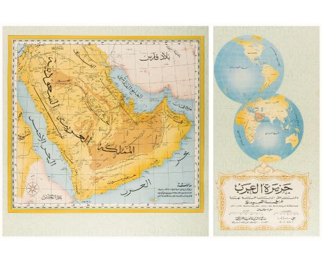
Lot 148
Middle East.- Persian Gulf.- Saudi Aramco (publisher) Jazirat al-'Arab wa-al-manatiq al-mutakhimah la-ha: kharitah tamhidiyah [The Arabian Peninsula and neighbouring regions: an introductory map], large wall map with detailed inset map of the Arabian peninsula with Arabic text, and two further hemispheres in the upper right, with Arabic title lower left, offset-lithograph printed in colours, split in two sections, total sheet when joined approx 840 x 1190 mm (33 x 46 3/4 in), professionally mounted on linen support, some small nicks to edges, unframed, Dharan, Arabian-American Oil Company, [1952]⁂ Scarce Aramco-issued wall map of the Arabian Peninsula, "prepared by the U.S. Ministry of the Interior and the U.S. Geological Survey, under the auspices of the Kingdom of Saudi Arabia, the Ministry of Petroleum and Mineral Resources, and the US Department of State". Printed entirely in Arabic; the annotations read: "The locations included in the basis of this map are dependent upon the best information available to us at their composition in 1942. The exact location of many of these locations goes back to the what the analyses and journeys of foreigners showed and is therefore subject to modification. This map does not denote the borders in obscure regions". Other notes on the map indicate that the borders in the southeast, southwest, the Empty Quarter, and the northwest have not been delineated. Curiously, the map retains the designation "Al-khalij al-farsi" for the Arabian (Persian) Gulf, reflecting Arab-world naming conventions of the early 1950s.

Lot 152
New Zealand.- Capt. James Cook.- Bénard (Robert) Carte de la Nle. Zelande Visitee en 1769 et 1770. par le Lieutenant J. Cook Commandant de l'Endeavour Vaisseau de sa Majeste, French edition of the map of the north and south islands, with details of Cook's voyage, engraving on laid paper with small bunch of grapes watermark, sheet 520 x 415 mm (20 1/2 x 16 1/4 in), old folds as issued, carefully re-margined to lower right of sheet, small associated tear, other minor nicks and handling creases, unframed, [1774]⁂ The first complete map of the two islands coastlines.

Lot 16
NO RESERVE English county maps.- Bowen (Emanuel) and others. Collection of over 80 18th and 19th century county maps, including Bowen's 'An Accurate Map of Devonshire' and 'An Improved Map of Wiltshire', 14 John Cary maps, including Cornwall, and others by Morden, Camden, Davies, Stockdale, and others similar, engravings, various sizes, all unframed, mainly 18th and 19th century; together with a small group of maps of Scotland, including Andrew Johnston's 'A New Map of the North Part of Scotland', Capt. Grenville Collins' 'Torbat', and 10 others, engravings, various sizes, all unframed, 18th and 19th century (c. 90)

Lot 52
NO RESERVE Nottingham.- Greenwood (C. & J.) Map of the County of Nottingham from an Actual Survey made in the years 1824 & 1825, large county map, calligraphic title in the upper left, engraving with original hand-colouring, 1415 x 1040 mm (55 3/4 x 41 in), dissected and mounted on linen, some corners lifting up, scattered surface dirt, spotting and browning, collectors signature in red ballpoint in the upper left, dated '1966', the map partially edged with green silk, some missing, folding with green endpapers, old library stamps partially peeled, presented in contemporary green morocco book-style slipcase, gilt, library sticker to spine, section to upper half of front spine missing, 4to, 1826; together with M. Ogle Tarbotton's nine section map 'Corporation of Nottingham. Proposed Borough Extension-Session 1876-1877', with key, and with Frederick Jackson's map '...Plan of the Town and County of the Town of Nottingham', various sizes, dissected and mounted on linen, folding into slipcase, and detached boards, respectively, 8vo, 1861-1877 (3)
Lot 43
London.- Bacon (George W.) Bacon's New Map of London divided into half mile squares and circles, lithograph with some hand-colouring, sheet 680 x 990 mm (26 3/4 x 39 in), mounted on linen, folding into original cloth boards, with 'Strangers Guide to London', upper cover embossed, rubbed and scuffed, 8vo, [circa 1890s].

Lot 142
NO RESERVE Holy Land.- Palestine.- Ortelius (Abraham) Palestinae Sive Totius Terrae Promissionis Nova Descriptio Auctore Tilemanno Stella Sigenens, map of the Holy Land, based on Tilemanno Stella's map of 1557, with elaborate strap-work cartouches, ships, and sea monster, engraving with early hand-colouring, on laid paper with armorial watermark, sheet 345 x 460 mm (13 1/2 x 18 1/8 in), Latin text verso, central vertical fold with careful repairs to splitting and some small losses restored, surface dirt, unframed, [Antwerp, 1579]Literature:VdB 171

Lot 123
Greece.- Speed (John) Greece, engraved map with hand-colouring, on laid paper with armorial watermark, platemark sheet 395 x 510 mm (15 1/2 x 20 1/8 in), central vertical fold with repairs to splitting, marginal nicks and tears, handling creases, printer's crease to left half, minor surface dirt, unframed, Bassett & Chiswell, [circa 1676].

Lot 104
Black Sea.- Turkey.- Faden (William) European Dominions of the Ottomans, or Turkey in Europe, map of the Balkan Peninsula, the southern parts of the Ukraine and Russia, all of the Black Sea, engraving with original outline hand-colouring, sheet 585 x 835 mm (23 x 32 7/8 in), minor handling creases, light surface dirt and browning, unframed, 1795.

Lot 95
America.- Canada.- Laurie & Whittle (publishers) A New and Correct Map of the British Colonies in North America comprehending Eastern Canada...with the adjacent states of New England, showing from New Jersey and Long Island, with Newfoundland and part of Hudson Bay, engraved map with outline hand-colouring, sheet 530 x 715 mm (20 7/8 x 28 1/4 in), small marginal tear to lower centre, spotting, browning and some surface dirt, unframed, 1794; together with 13 other maps of North America and Canada, including maps by Thomas Tegg, Cadell & Davies, and A.J. Johnston, various sizes, all unframed, 18th and 19th century (14)

Lot 28
Hertfordshire.- Speed (John) Hartfordshire Described, inset views of Hertford, Roman St Albans, text panels, with battle scene and allegorical figure with astrolabe below, engraved map by Jodocus Hondius, with hand-colouring, on laid paper with watermark of grapes, platemark 385 x 510 mm (15 1/8 x 20 in), sheet 428 x 560 mm (16 3/4 x 22 in), woodcut initial of John Legatt verso, central vertical fold with repairs to splitting and small losses, marginal nicks and tears to extremities, light browning and surface dirt, unframed, William Humble, [1646].
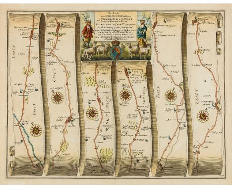
Lot 6
NO RESERVE British road maps.- Ogilby (John) The Roads from Chelmsford in Essex to St. Edmonds-Bury in Suffolk & Saffron-Walden in Essex, strip road map, engraving with hand-colouring, on thin laid paper with armorial watermark, sheet 385 x 460 mm (15 1/8 x 18 1/8 in), central vertical fold, minor splitting to fold, minor surface dirt, unframed, [1676]; together with 5 further Ogilby strip road maps, including 'London to Barstable', 'The Road from Oxford to Bristol', 'London to Harwich', 'Bristol to Exeter', and 'London to Lands-End', engravings, 3 with hand-colouring, 2 un-coloured, each approximately 370 x 450 mm (14 1/2 x 17 3/4 in), rough edges, nicks and tears, some splitting to folds, occasional spotting, browning and surface dirt, one sheet mounted on support, unframed, [c. 1676] (6)

Lot 97
America.- Boston.- Tallis (John) Boston, detailed map with vignette view of Boston viewed from across the harbor, and two smaller views of Bunker's Hill Monument and the State House, engraving with hand-colouring, on thin wove paper, sheet 265 x 360 mm (10 1/2 x 14 1/4 in), some exposure lines and light surface dirt, unframed, [1851]; together with S.D.U.K.'s 'Boston with Charlestown and Roxbury', engraved plan with hand-colouring, sheet 398 x 342 mm (15 5/8 x 13 1/2 in), some browning and minor handling creases, unframed, Chapman & Hall, 1842 (2).

Lot 20
NO RESERVE Channel Islands.- Cochrane (James) A Map of the Island of Guernsey, likewise all the Adjacent Rocks, Shoals & Passages, with the Tides, Soundings, Anchorages, &c., detailed map of the island with highlighted boundaries including the track of H.M.S. Crescent and squadron commanded by Lord de Saumarez when pursued by a French force, engraving on wove paper, sheet 600 x 750 mm (23 1/2 x 29 1/2 in), old folds, some splitting and small areas of loss, scattered spotting and surface dirt, unframed, 1832; together with six further small maps of the Channel Islands, unframed, 18th and 19th century (7)⁂ Scarce at auction. The last example we can trace was sold at Christie's in 1998 (see: Lot 26, 14th May 1998, where one sold for £322).

Lot 92
Africa.- d'Anville (Jean Baptiste Bourguignon) Africa according to Mr. D'Anville with several additions and improvements, large map of Africa by Robert Sayer, decorated with an rococo cartouche, with a stylized representation of African men, women, and child, with inset chart of the Gold Coast to the lower left, engraving with outline hand-colouring, presented over four sheets, joined in two horizontal sections, each section approx. 535 x 1240 mm (21 x 48 3/4 in), total if joined 1070 x 1240 mm (42 1/8 x 48 3/4 in), horizontal folds as issued, minor offsetting, and surface dirt, unframed, Robert Sayer, 1722.
![Middle East.- Ruscelli (Girolamo) Arabian Felice Nuova Tavola [Arabian Peninsula], Ptolemaic map of the Arabian Peninsula bas](https://cdn.globalauctionplatform.com/b2e0cc76-940f-48a0-b6c7-ae3600f31b48/871f93c5-f0b4-42e4-90ba-ae3600f651d6/468x382.jpg)
Lot 143
Middle East.- Ruscelli (Girolamo) Arabian Felice Nuova Tavola [Arabian Peninsula], Ptolemaic map of the Arabian Peninsula based on the 1548 map of Giacomo Gastaldi, engraving with hand-colouring, on laid paper without watermark, platemark 192 x 265 mm (7 5/8 x 10 1/2 in), sheet 225 x 325 mm (8 3/4 x 12 3/4 in), Italian text verso, central vertical fold with careful repairs verso, minor surface dirt, unframed, [Venice, 1561-1599].

Lot 154
South America.- Collection of nine maps of South American countries, including four maps of Peru and Ecuador by Bellin, focussing on Lima and Upper Peru, map of Chile and Brazil by Lizars, Moll's 'Peru and the Amazones Country' and 'A Map of Chili, Patagonia, La Plata and ye Southern Part of Brasil', and another early map of Peru, engravings, some with hand-colouring, various sizes between 200 x 260 mm (8 x 10 1/4 in) and 520 x 410 mm (20 1/2 x 16 1/4 in), all unframed, 18th and 19th century (9)

Lot 109
Crimean Peninsula.- Wyld (James) The Crimea, detailed map with inset of the Black Sea and environs, another with plan of 'The Town and Harbour of Sevastopol with the Batteries & Approaches', engraving with hand-colouring, 480 x 685 mm (18 7/8 x 27 in), mounted on linen, some staining and surface dirt, with publisher's advertisement to endpaper, folding into original purple cloth with gilt title to upper cover, rubbed and worn, 8vo, 1855.

Lot 113
Europe.- Arrowsmith (Aaron) Map of Europe drawn from all the best surveys and rectified by astronomical observations, large engraved map with contemporary outline hand-colouring, presented in two horizontal sections, each section approx. 640 x 1495 mm (25 1/4 x 58 7/8 in), dissected and mounted on linen, some toning, spotting and surface dirt, remnants of silk edges, folding into contemporary slip-case, split and very worn, 4to, 1798.

Lot 71
Scotland.- Morden (Robert) A New Map of the North Part of Scotland; A New Map of the South Part of Scotland, two maps with an inset of the Shetland Islands, engravings with full hand-colouring, on laid paper without watermark, each platemark approx. 360 x 460 mm (14 1/4 x 18 in), full margins, minor exposure lines, some brownign and surface dirt, unframed, 1753 (2)

Lot 67
NO RESERVE Ireland.- Chatelain (Henri Abraham) Nouvelle Carte De L'Irlande..., map of Ireland, with two further inset maps of ancient Ireland and an ecclesiastical map of modern Ireland in the upper corners, engraving with full hand-colouring, on laid paper without watermark, platemark 350 x 465 mm (13 3/4 x 18 1/4 in), good margins, minor spotting and surface dirt, unframed, Paris, [1719]; together with a group of 8 further maps of Ireland, including a slightly compromised Mount & Page 'A Chart of the Coasts of Ireland and Part of England', Mercator's 'Udrone Irlandiae in Catherlagh Baronia', John Seller's 'A Chart of the North West Coast of Ireland from Lough Swilly to Slyne Head', Blaeu's 'Baronia Udrone in Comitatu Catherloughae', and others by Russell, Stockdale, S.D.U.K., and others, engravings, various sizes, all unframed, 17th to 19th century (9)
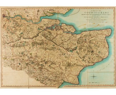
Lot 31
NO RESERVE Kent.- Faden (William) A Map of the County of Kent, Drawn from the Topographical Survey Taken by Order of the Honourable Board of Ordnance under the direction of Lt. Colonel Wm Mudge, county map with part of London in the upper left, engraving with original hand-colouring, sheet 625 x 885 mm (24 1/2 x 34 3/4 in), dissected and mounted on linen, some surface dirt and browning, folding with green marbled ends with publisher's stamp of R.H. Laurie, contemporay marbled slipcase, manuscript label to upper cover, rubbed and worn, 8vo, 1807; together with 'The Times Survey Atlas of the World', 1920, two Walker's county maps of Wiltshire and Buckinghamshire, and Andrew Tuer's 'Old London Street Cries', 12mo, 1885 (5)
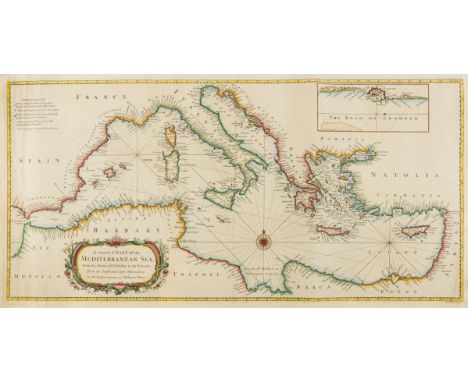
Lot 140
Mediterranean.- Seale (Richard William) A correct Chart of the Mediterranean Sea, from the Straits of Gibraltar to the Levant, chart of the Mediterranean focusing on the coastlines, with inset map of The Road of Leghorn (Livorno harbor) in the upper right, engraving with hand-colouring, 350 x 725 mm (13 3/4 x 28 1/2 in), old vertical folds, repairs to some minor nicks to left edge, unframed, [circa 1745].

Lot 41
London.- Cruchley (George Frederick) Reduced Ordnance Map of London, central London, extending from Notting Hill to Bethnal Green, and from Kentish Town to Battersea Park, folding lithographed map, sheet , 660 x 870 mm (26 x 34 1/4 in), old folds, some splitting, old handling creases with nicks and tears, folding into contemporary boards with publisher's printed label to upper cover, rubbed and worn, 8vo, [1875]; together with seven other maps of London, including 'Cary's Actual Survey of the Country Fifteen Miles Round London', and Cary's [Map of London and its Environs], and others, folding, various sizes, 8vo, 19th and 20th century (8)

Lot 84
NO RESERVE Celestial chart.- Schraembl (Franz Anton) Stereographischer Entwurf des Gestirnten Himmels, detailed chart of the Northern Celestial Hemisphere, the constellations presented as figures according to classical mythology, engraving with outline hand-colouring, on laid paper with watermark 'C & I Honig', platemark 640 x 640 mm (25 1/4 x 25 1/4 in), sheet 965 x 640 mm (38 x 25 1/4 in), minor spotting and surface dirt, unframed, rolled, Vienna, 1787; together with a Welsh-language double-hemisphere world map, the folding frontispiece to Robert Saunderson's 'Geiriadur Ysgrythyrol...', engraving, 235 x 370 mm (9 1/4 x 14 1/2 in), folding and attached to title, both with surface dirt, stains, and browning, unframed, 1836 (2)
![Europe.- Hadol (Paul) A New Map Designed for 1870 [or] Carte Drolatique D'Europe Pour 1870 Dressee Par Hadol, serio-comic map](https://cdn.globalauctionplatform.com/b2e0cc76-940f-48a0-b6c7-ae3600f31b48/271f46a0-3c8c-45e6-a60b-ae3600f6268b/468x382.jpg)
Lot 114
Europe.- Hadol (Paul) A New Map Designed for 1870 [or] Carte Drolatique D'Europe Pour 1870 Dressee Par Hadol, serio-comic map of Europe on the cusp of the Franco-Prussian War, English language edition with French text, lithograph with hand-colouring on thin wove paper without watermark, sheet 355 x 430 mm (14 x 17 in), central vertical fold with green support verso, splitting and small loss to upper section of fold, other old folds and handling creases, unframed, 1870Literature:cf. Tooley Geographical Oddities, MCC1, #75-79
Lot 44
London.- Bacon (George W.) Bacon's Large Scale Atlas of London and Suburbs (Revised Edition), complete with title, contents, 7 maps of the home counties, and 40 double-page maps including 14 special maps and plans of central London, lithographs with some hand-colouring, each approx. 350 x 525 mm (13 3/4 x 20 3/4 in), occasional finger-soiling, surface dirt and minor browning, some tears into sheets including the index map and plan of Central London, some tabs with associated splitting, one detached, other scattered smaller nicks, contemporary half calf, upper cover with gilt title, spine with losses and rubbing, corners bumped and slightly worn, folio, [1914]
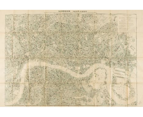
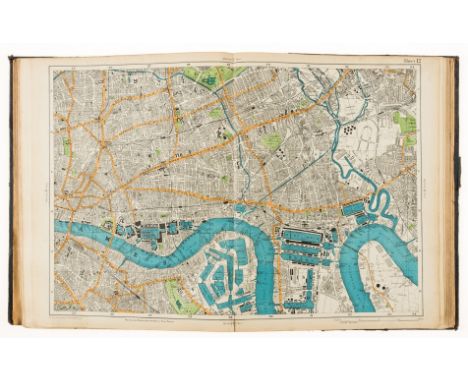
Lot 51
Pub map of London.- Booth (Charles) London 1889-1900, from "Life and Labour of the People in London", Map showing Places of Worship, Public Elementary Schools, and Houses Licensed for the Sale of Intoxicating Drinks, lithograph, 670 x 1000 mm (26 1/2 x 39 3/8 in), folding as issued, some handling creases, light surface dirt and browning, presented in slip to rear of "Final Volume" of Booth's series, modern green cloth, ex-Maidstone Public Library with stamps, 4to, MacMillan & Co, 1902⁂ This detailed map of London shows the proximity of drinking establishments to schools and places of worship, and with such a vast number of places selling alcohol, Booth to concluded that London's Temperance Movement had failed.

Lot 147
NO RESERVE Middle East.- Oman.- War Office (Geographical Section) Salala, showing Kuria Maria Bay, Saquira Bay, and part of the Gulf of Misira, lithographed map printed in colours, sheet 630 x 830 mm (24 3/4 x 32 3/4 in), mounted on linen, old folds, some surface dirt and minor browning, unframed, 1946.
Lot 128
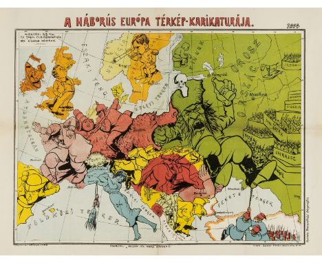
Hungary.- Serio-Comic War Map.- Varga (Imre) A Háborús Európa Térkép-Karikatúrája, Hungarian pictorial map with Russia drunk on Vodka, who is keeping his army reserves held back, colour-printed lithograph on wove paper, sheet 415 x 550 mm (16 1/4 x 21 3/4 in), old folds with conservation support visible verso, repairs to splitting and minor loss to folds restored, minor surface dirt, unframed, [Budapest], published by Zeizler Sándor, 1914.⁂ Scarce. The only WWI serio-comic map to illustrate Hungary independent from Austria.
Lot 158
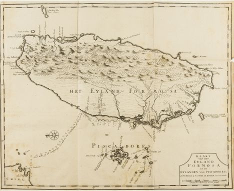
Taiwan.- Valentyn (Francois) Kaart van het Eyland Formosa en de Eylanden van Piscadores, map of Formosa oriented to the east, covering the entire island, including the Penghu Islands and part of the Chinese coast, based on Johannes Vingboon's manuscript map of 1640, engraving on laid paper with watermark of Strasburg lily and 'IV', sheet 485 x 570 mm (19 x 22 1/2 in), old folds, upper left edge trimmed within the platemark, small nick to centre right edge affecting printed border, minor spotting and surface dirt, minor nicks to extremities, unframed, Joannes van Braam and Gerard onder de Linden, [1726]; together with Ogilby's 'Fezzae et Marocchi regna Africae Celeberrima', engraving, sheet 305 x 385 mm (12 x 15 1/8 in), unframed, [c. 1670] (2)⁂ The first printed map of Taiwan.
![NO RESERVE Greece.- Visscher (Nicolas) Hellas [Greek] Seu Graecia Universa, engraving with original hand-colouring, 495 x 600](https://cdn.globalauctionplatform.com/b2e0cc76-940f-48a0-b6c7-ae3600f31b48/dbbe3989-a668-4925-8909-ae3600f6a48b/468x382.jpg)
Lot 122
NO RESERVE Greece.- Visscher (Nicolas) Hellas [Greek] Seu Graecia Universa, engraving with original hand-colouring, 495 x 600 mm (19 1/2 x 23 5/8 in), central vertical fold with old repairs to splitting, rough edges with tape stains, nicks and tears, some marginal losses, unframed, circa 1650; together with Bonne's regional map of Asia, La Presqu'Isle de L'Inde Au Dela du Gange, engraving, 420 x 290 mm (16 1/2 x 11 1/2 in), surface dirt and browning, unframed, 1787 (2)

Lot 79
World.- Various cartographers (18th and 19th century) Collection of six maps of the world, including Guthrie's 'Chart of the World, according to Mercator's Projection shewing the Tracks & Discoveries of Capt. Cook', 'A Map of the World from the Best Authorities', another reduced 'Map of the World' by B. Baker, A. Bell's 'Geography. Map of the World, comprehending the latest discoverys', Arrowsmith's 'World on Globular Projection', and J. Archer's 'The World. On Mercator's Projection', engravings with hand-colouring, various sizes between 270 x 350 mm (10 5/8 x 13 3/4 in) to 410 x 505 mm (16 1/8 x 19 3/4 in), some old folds and handling creases, minor surface dirt and light browning, unframed, late 18th and 19th century (6)
Lot 156
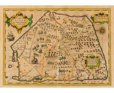
NO RESERVE Sri Lanka.- Mercator (Gerard) and Jodocus Hondius. Ins. Ceilan quae incolis Tenarisin dictur, map of Ceylon (Sri Lanka), oriented with east at the top and includes elephants, gazelles and other animals, sailing ships, compass roses and 3 cartouches, engraving with hand-colouring, platemark 350 x 500 mm (13 3/4 x 19 3/4 in), sheet 455 x 540 mm (17 7/8 x 21 1/4 in), Latin text verso, even toning and surface dirt, some marginal nicks and small losses, unframed, [circa 1620].

Lot 27
Speed (John) Hantshire described and devided, county map with inset town plan of Winchester in the upper left corner, engraving with hand-colouring, 385 x 510 mm (15 1/8 x 20 in), woodcut initial of John Legatt verso, central vertical fold with some splitting and old repairs, marginal tape-stains and surface dirt, a few minor nicks, unframed, William Humble, [1646].

Lot 25
Essex.- Speed (John) Essex devided into Hundreds with the most antient and fayre towne Colchester described and other memorable monuments observed, county map with inset map of Colchester in the lower right corner, London in the lower left corner of the map, engraving with hand-colouring, platemark 390 x 510 mm (15 3/8 x 20 in), sheet 430 x 550 mm (17 x 21 3/4 in), even toning, minor surface dirt, marginal nicks and tears, unframed, George Humble, [1627].

Lot 126
Hungary.- Ortelius (Abraham) Hungariae Descriptio, Wolfgango Lazio. Auct., map showing Hungary, eastern Transylvania, and Bulgaria, engraving with some early hand-colouring, an excellent impression on laid paper with armorial watermark, platemark 350 x 500 mm (13 3/4 x 19 3/4 in), sheet 425 x 570 mm (16 3/4 x 22 1/2 in), Latin text verso, some handling creases, minor surface dirt, unframed, [circa 1584]

Lot 22
Dorset.- Speed (John) Dorsetshyre, county map with inset plan of Dorchester, engraving with hand-colouring, platemark 383 x 510 mm (15 1/8 x 20 in), sheet 445 x 565 mm (17 1/2 x 22 1/4 in), woodcut initial of Roger Rea verso, marginal nicks, some minor surface dirt, unframed, Bassett & Chiswell, [1676]

Lot 10
England & Wales.- Cary (John) Cary's New Map of England & Wales, with Part of Scotland, large folding engraved map in the three horizontal sections, with general map, title, and dedication, each section approx. 745 x 1770 mm. (29 1/4 x 69 3/4 in), dissected and mounted on linen, green silk edges, minor offsetting and light browning, in book-style envelope slipcase, gilt, rubbed and scuffed, 4to, 1794.
Lot 105
Canada.- Jefferys (Thomas) An Exact Chart of the River St. Laurence, from Fort Frontenac to the Island of Anticosti Shewing the Soundings, Rocks, Shoals &c..., large-scale navigational chart of the St. Lawrence River, with Quebec in the lower left corner, numerous soundings and sailing directions, with coastal profiles and inset maps of specific sections of the river, engraving on two sheets of thick laid paper conjoined and mounted on conservation support, total sheet 610 x 950 mm (24 x 37 1/2 in), some small losses within the map, restored, other repairs to tears and splitting, rough edges, some surface dirt, unframed, Robert Sayer, 1775.

Lot 96
America.- Various cartographers (18th and 19th century) Collection of five maps of America, including an unidentified Western hemisphere map with the voyages of Capt. Cook, J.H. Colton's double-page map 'Colton's United States of America', and G.H. Swanston's 'United States North America', 'United States North America [...] The South Central Section', and another of the same, engravings with hand-colouring, various sizes, 440 x 695 mm (17 1/4 x 27 1/4 in), and smaller, handling creases and minor surface dirt, unframed, 19th century (5)
![Middle East.- Ruscelli (Girolamo) Tabula Asiae VI [Arabian Peninsula], Ptolemaic map of the Arabian Peninsula engraving with](https://cdn.globalauctionplatform.com/b2e0cc76-940f-48a0-b6c7-ae3600f31b48/17dde0c7-cccb-46d4-9001-ae3600f5d184/468x382.jpg)
Lot 144
Middle East.- Ruscelli (Girolamo) Tabula Asiae VI [Arabian Peninsula], Ptolemaic map of the Arabian Peninsula engraving with hand-colouring, on laid paper without watermark, platemark 192 x 265 mm (7 5/8 x 10 1/2 in), sheet 225 x 325 mm (8 3/4 x 12 3/4 in), Italian text verso, central vertical fold with careful repairs verso, minor surface dirt, unframed, [Venice, 1561-1599].

Lot 54
NO RESERVE Oxford & Eastern counties.- Kitchin (Thomas) A new Improved Map of Oxfordshire from the best surveys and intelligences, divided into hundreds, county map with decorative title cartouche in the lower left corner, engraving with hand-colouring, 715 x 540 mm (28 1/4 x 21 1/4 in), horizontal fold, wide margins with nicks and tears, unframed, [1764]; together with 11 others, including Bowen's 'An Accurate Map of of Cambridgeshire Divided into its Hundreds...', Bowen's 'An Accurate Map... of Suffolk Divided into its Hundreds...', Saxton & Lea's 'Cambridge-Shire and The Great Levell of ye Fenns', and others by Robert Morden, Charles Smith, and others, engravings, various sizes, all unframed, 17th to 19th century (12)

Lot 9
NO RESERVE English county maps.- Northern England.- Speed (John) Anno Darbieshire described, county map, inset town plan of Derby and inset view of St Anne's well at Buxton, engraving, 385 x 510 mm (15 1/4 x 20 in), sheet 425 x 550 mm (16 3/4 x 21 3/4 in), central vertical fold with some splitting and loss, minor spotting and surface dirt, unframed, Sudbury & Humble, [1610 but later]; together with 17 others, including Blaeu's 'Ducatus Eboracensis pars Orientalis, The East Riding of Yorkshire', Jansson's 'Northumbria, Cumberlandia, Dunelmesis Episcopatus', Morden's 'The West Riding of Yorkshire', Cary's 'Northumberland' and 'Durham', and others, engravings, various sizes, all unframed, 17th to 19th century (18)
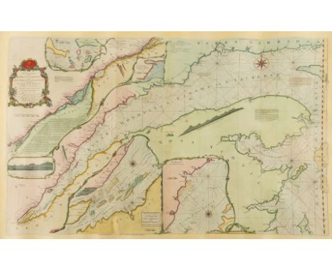
Lot 32
NO RESERVE London and River Thames.- Harris (John) The East Part of the River Thames, The West Part of the River Thames, panoramic map showing the course of the River Thames, from its spring in Gloucestershire to its estuary, engraving with original hand-colouring, on laid paper without watermark, sheet 225 x 385 mm (8 3/4 x 15 1/8 in), caeful repairs to splitting and loss, some surface dirt and browning, unframed, [1720]; together with 18 road strip maps of the London and its environs, including Weller's 'The River Thames from its Source to the Sea', 11 small road strip maps by Thomas Kitchin, and others similar, various sizes, all unframed, 18th and 19th century (19)

Lot 74
Wales.- Ortelius (Abraham) Cambriae Typus Auctore Humfredo Lhuydo Denbigiense Cambrobritano, map of Wales, with details of mountain ranges, forests, and towns, strap-work title cartouche, sea monster, and ship off the coast, engraving with some early hand-colouring, on laid paper with indistinct armorial watermark, platemark 370 x 490 mm (14 1/2 x 19 1/4 in), small margins, German text verso, repaired tears and marginal loss to upper edge, the loss not affecting the map, minor surface dirt, central vertical fold reinforced verso, some minor splitting repaired, unframed, [Antwerp, circa 1590s]Literature:VdB 21

Lot 60
NO RESERVE Sussex.- Jansson (Jan) Suthsexia vernacule Sussex, map of the county, engraving with later hand-colouring, platemark 385 x 515 mm (15 1/8 x 20 1/4 in), good margins, German text verso, central vertical fold with minor splitting, exposure lines to edges, minor surface dirt, unframed, Amsterdam, [1648]

Lot 157
NO RESERVE Sweden.- Hermelin (S.G.) Karta öfver Gottland eller Wisby höfdingedöme, large map of the Swedish island and province in the Baltic Sea, engraving with hand-colouring, on thick wove paper, platemark 950 x 625 mm (37 1/2 x 24 1/2 in), sheet 1040 x 665 mm (40 7/8 x 26 1/4 in), old folds with minor splitting, some light offsetting and minor nicks to edges, unframed, C.P. Hallstrom, 1805; together with a mixed group of 13 maps, including de Vaugondy's 'Royaume de Hongrie', Chatelain's 'Carte de L'Asie', Bowen's 'A New and Accurate Map of Europe', Hondius's 'Warwicum Northamtonia Huntingdonia Cantabrigia', and others, various sizes, all unframed, 17th to 19th century (14)

Lot 15
Southern England.- Bradshaw (George) Map of Canals, Navigable Rivers, Railways &c., in the Southern Counties of England, large detailed map with London in the upper right, engraving with bright full hand-colouring, an excellent impression, total sheet 980 x 1900 mm (38 3/4 x 74 3/4 in), dissected and mounted on linen, with green silk ties, folding into calf book-style slipcase, morocco label to spine, very worn, missing top strip of case, 4to, 1832.

Lot 145
Middle East.- Ortelius (Abraham) Persici sive Sophorum Regni Typus, Persia from the Caspian Sea to the Red Sea with strapwork title cartouche in the lower right corner, engraved map with hand-colouring on laid paper without visible watermark, platemark 355 x 510 mm (14 x 20 1/8 in), sheet 470 x 580 mm (18 1/2 x 22 3/4 in), French text verso, very thin conservation tissue verso, minor surface dirt, unframed, [circa 1590 or slightly later].
-
109182 item(s)/page