We found 109198 price guide item(s) matching your search
There are 109198 lots that match your search criteria. Subscribe now to get instant access to the full price guide service.
Click here to subscribe- List
- Grid
-
109198 item(s)/page


Lot 451
John Speede, an original coloured map of Glamorganshire, Bassett and Chiswell edition with English text verso. Hogarth frame. Together with a facsimile John Speede map of Cardiganshyre. (2) (B.P. 24% incl. VAT) CONDITION REPORT: Obvious crease down the middle. Decent colour. Overall good for age.


![Palmer [W.T.] - Penguin Guides - The Lake District, ed. L. Russell Muirhead, first edition 1939, paper bound, and nine Ordnan](https://cdn.globalauctionplatform.com/be38e52d-c8bd-4d40-ad89-a85f00ec7ebd/54ff990c-9575-49d0-a349-73f001bdc240/468x382.jpg)


Lot 87
Thrace, Maroneia. Silver Stater (11.37 g), ca. 386/5-350 BC. Ikesio…, magistrate. MAPΩ, horse galloping left, reins trailing. rev. Grape vine with four bunches of grapes within linear square; in left field, caduceus; around, magistrate's name: EΠI IKE-ΣIO; all within shallow incuse square. Schönert-Geiss 425 (same dies); SNG Lockett 1200 (same dies). Boldly struck in high relief and well centered. Nicely toned. Extremely Fine. Estimated Value $2,500 From the Dionysus CollectionEx Hess-Divo 317 (2010), lot 97.

Lot 88
Thrace, Maroneia. Silver Tetradrachm (16.91 g), ca. 189-49 BC. Wreathed head of Dionysos right. rev. ΔIONYΣOY ΣΩTHPOΣ MAPΩNITΩN, Dionysos standing facing, head left, holding bunch of grapes and narthex stalks; in inner left field, monogram. Cf. Schönert-Geiss 979 (dies?); SNG Copenhagen -. Removed from an NGC holder where graded MS, strike: 4/5, surface: 2/5, edge bend. As struck. Estimated Value $350 From the Dionysus Collection.

Lot 2140
Medal. Silver. 91.5 mm. 255.2 gm. By J.B. Gass. Count Alexey Grigorievich Orlov. Award Medal of the Admiralty Collegium, 1770. Diakov 153.1, Reichel 4469, Tiregal 107. Uniformed half-length bust of Count Orlov r., head facing, wearing the plumed helmet of the Cavalry Guard helmet, and holding a staff / Intricate map of Chesmé Bay showing the Russian and Turkish fleets arrayed in their battle positions, small cherub head below blowing the wind right. Extremely rare. Light golden tone over numerous contact marks and few old scratches. About Extremely Fine. Estimated Value $7,500 Ex Glendining & Co, London, 13 May 1992, lot # 141.Ex "The New York Sale", New York, January 7, 2010, lot # 1122. This magnificent piece was issued as an Award Medal for the Archipelago Expedition of 1769-1770 during the Russo-Turkish War of 1768-1774. Count Orlov had entered the Mediterranean to destroy the Ottoman fleet and rebellion encourage among the Greeks in the Morea. The Russian victory at Chesmé was decisive, with the Ottoman fleet burned. Following further setbacks on the Danube, the Sublime Porte was forced to sign the Treaty of Ku¨.u¨k Kaïnarji (1774), concluding the war. Gold and Silver Medals were presented to high-ranking officers and participants in the Battle of Chesmé. Meanwhile, during the anniversary celebrations of June 24, 1771 marking the naval victory, all attendees were presented with medals honoring Count Orlov, presumably nearly all Bronze.

Lot 345
Commodus. Æ 16 (3.93 g), AD 177-192, Neapolis in Samaria. MAP AYP KOMMOΔω, laureate, draped and cuirassed bust of Commodus right. rev. [ΦΛ NEAC] CYPI Π, Tyche-Astarte standing left, resting foot on prow(?), holding bust and long scepter. Rosenberger 24; RPC temp. 6355. Light earthen-green patina. About Extremely Fine. Estimated Value $300 From the Dr. Patrick Tan Collection.
Lot 1239
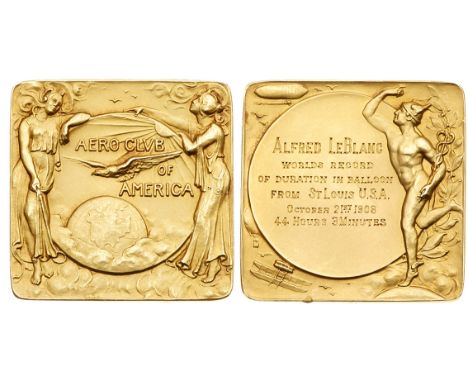
USA, 2nd Gordon Bennett Ballooning Cup, 1908 Prize medal. Struck in 18 carat gold and awarded to Alfred LeBlanc, AERO CLVB OF AMERICA, globe with female figure each side, at centre an orb with North America’s map emerging from the clouds, American eagle flying above, rev. Hermes standing right along 6 lines legend within circle, ALFRED LEBLANC, WORLDS RECORD OF DURATION IN BALLOON FROM ST LOUIS U.S.A. OCTOBER 21ST 1908 44 HOURS 3 MINUTES, a zeppelin, a hot air balloon and a biplane in the surroundings, 36 x 36cm, 34.33g. Unsigned medal with a small knock on lower edge, very elegant Art Nouveau style, toned, unique. Estimated Value $2,800 Alfred LeBlanc and his American co-pilot Edgar W. Mix covered a distance of 866,867 miles and finished second behind the German team made of Oskar Erbslöh and his American co-pilot Henry Helm Clayton who covered 872,253 miles. However, the French team achieved a new world record for duration, 44 hours and 3 minutes in the air while the German team managed only 44 hours in the air.


Lot 156
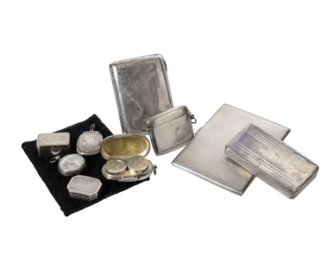
A collection of silver boxes, comprising: a George III canted-rectangular vinaigrette by Robert Urquhart, London 1801, a Victorian rectangular vinaigrette by Sampson Mordan & Co., Birmingham 1883; a Victorian oblong double sovereign case by Wright & Davies, London 1889; a wrythen moulded sovereign case, marks worn, Birmingham 1896; an oblong pill box by Adie & Lovekin Ltd, Birmingham 1912, initialled; a vesta case by W. J. Myatt & Co., Birmingham 1915, monogrammed; a rectangular cigarette case by Thomas William Lack, London 1933, the cover engraved with a map of the United Kingdom with some major cities, presentation engraved inside, 11.5cm (4 1/2in) long; another cigarette case, engraved with facsimile signatures overall; and a 19th century French rectangular snuff box, 430g (13.85 oz) gross (9)


Lot 25
Selection of map prints including Yorkshire Parts of East & West Riding, Flintshire, Brecknockshire, Cardiganshire, Leistershire etc 'coloured engraved book plates' including Worsley Hall, Bolton Castle Yorkshire, Fountains Abbey Yorkshire, Middleham Castle Yorkshire, 'black & white engraved book plates' including Halifax, Sheffield, Bradford, Saltaire, Town Hall Leeds, Huddersfield and unframed hunting prints etc


-
109198 item(s)/page