We found 109198 price guide item(s) matching your search
There are 109198 lots that match your search criteria. Subscribe now to get instant access to the full price guide service.
Click here to subscribe- List
- Grid
-
109198 item(s)/page


Lot 258
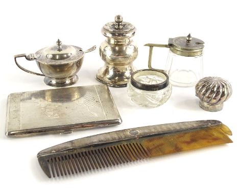
A collection of small silver etc., to include a coffee grinder, scent bottle lid, mustard pot with hinged lid, a silver coloured metal cigarette case, engraved with a map of India and with a personal inscription to the interior dated 1945, and a small mustard pot with angular handle in the manner of Christopher Dresser, etc.


Lot 491
A collection of books relating to Norfolk and Suffolk, to include Wry (Norfolk families), Mortlock and Roberts Guide to Norfolk Churches, Suffolk Churches and their Treasure by Cautley (H. Monroe), two volumes, and Kirby (John), The Suffolk Traveller, second edition, with map, various notes by previous owners, later brown leather and marbelled binding, and two volumes of White's 1845 Norfolk, published by David and Charles, reprints.


Lot 961
A Nathaniel Hill 2 3/4in. (7cms) pocket globe, English, published 1754, cartouche printed 'A New Terrestrial GLOBE by Nath. Hill 1754', hand-coloured gores with California shown as a peninsula, the Antarctic lacks definition and labelled "Ice Sea", Australia lacking East Coast definition and titled New Holland and North West portion of North America labelled "Unknown Parts", (hairline crack to much of equator), in fishskin case with map of the heavens applied to the inner semi-spheres, 3in. (7.5cm) diameter.


Lot 804
BAUER, Ferdinand (1760-1826, artist). The Australian Flower Paintings of Ferdinand Bauer ... Introduction by Wilfrid Blunt. London: The Basilisk Press, 1976. Large folio (630 x 450mm). Text by William T. Stearn, double-page map of Australia, 25 mounted coloured plates after Ferdinand Bauer. Original green leather-backed marbled boards by A. W. Lumsden, Edinburgh, box. Provenance: Sir Giles Loder, Bart.(modern bookplate). NUMBER 388 OF 500 COPIES FOR SALE. Loosely-inserted is an original prospectus for the publication indicating that its published [retail] price in 1976 was £420. The prospectus states: "Plates used in all titles [of The Basilisk Press] are destroyed after printing has been completed, thus ensuring that no edition can be extended or repeated." Also loosely-inserted is an unrelated modern limited edition flower print.
Lot 814
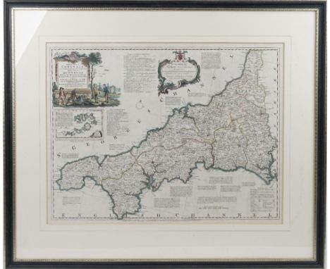
CORNWALL - Thomas KITCHIN (1718-84). A New Improved Map of Cornwall from the Best Surveys and Intelligencies Divided into its Hundreds. London: Printed for T. Bowles, [c. 1750]. Large hand-coloured engraved map, title within fully hand-coloured figural cartouche, dedication within baroque cartouche, inset map of The Isles of Scilly (some very light spotting), 515 x 680mm., framed and glazed.
Lot 825
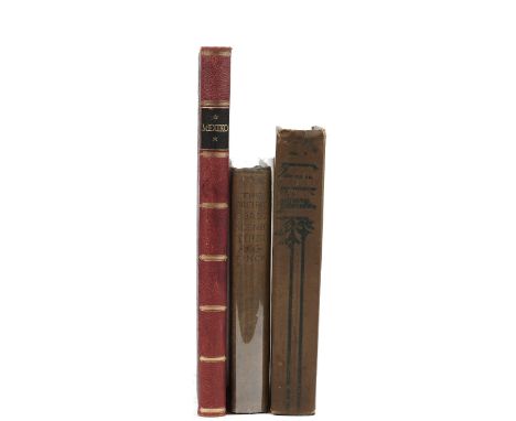
FINCK, Henry Theophilus (1854-1926). The Pacific Coast Scenic Tour. From Southern California to Alaska, the Canadian Pacific Railway, Yellowstone Park and the Grand Canyon. London: Sampson Low, Marston, Searle, & Rivington, 1891. 8vo (206 x 140mm). Half title, photographed frontispiece, map, and 19 photographed plates (one text leaf torn without loss, some light mainly marginal spotting and staining). Original green decorated buckram (spine slightly discoloured, a little faded). First published in New York in 1890. cf. Carson 605; Smith 104. With Thomas D. Murphy's Three Wonderlands of the American West ... New Revised Edition (Boston, [n.d.], original pictorial buckram) and Hugo Brehme's Mexico. Baukunst. Landschaft. Volksleben (Berlin, 1925, half roan). (3)
Lot 830
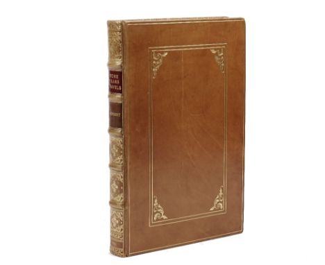
HERBERT, Thomas (1606-82). Some Years Travels into Divers Parts of Africa and Asia the Great. Describing More particularly the Empires of Persia and Industan: Interwoven with suchj remarkable Occurrences as hapned[sic] in those parts during these later Times. As also, many other rich and famous Kingdoms in the Orientall India, with the Isles adjacent. Severally relating their Religion, Language, Customs and Habit: as also proper Observations concerning them. The Third Impression much Enlarged, with many Additions, nigh a third part more then[sic] there was in any of the former impressions, besides the addition of many new and lively Brass-cuts. London: Printed by J. Best for Andrew Crook, 1665. Folio (286 x 188mm). Additional engraved title with baroque cartouche, woodcut headpieces and historiated initials, folding engraved plate of Persepolis, 48 engraved illustrations and maps including one full-page map (some repairs to both titles affecting a few letters, small hole in printed title not affecting letters, short marginal tear at foot of both titles, small rusthole in Oo2 touching letters, some dark spots and a few stains, some light staining and browning). FINELY BOUND in modern polished panelled calf gilt, spine gilt with red and tan morocco lettering-pieces, raised bands, gilt edges, new endpapers. The binding is, perhaps surprisingly, unsigned. Provenance: D. [?]Thomas (old signature at head of both titles). Wing H1534; Sabin 31471. The work was first published in 1634. There is an illustration of a man being eaten by a "Sharke fish" on p. 7 and an illustration of a Dodo on p.403.
![[JANSSON, Jan (1588-1664)]. Aethiopia superior vel interior; vulgo Abissinorum sive Presbiter Joannis Imperium. [Amsterdam:](https://cdn.globalauctionplatform.com/55ca2bbb-26d6-40cd-87ba-abec00be1828/d4370ad0-9e90-42ff-97e2-abed00948108/468x382.jpg)
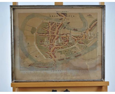
Lot 833
[JANSSON, Jan (1588-1664)]. Aethiopia superior vel interior; vulgo Abissinorum sive Presbiter Joannis Imperium. [Amsterdam: c. 1640]. Hand-coloured engraved map, hand-coloured figural title cartouche with native figures and putti, elephants, monkeys and ostriches, 382 x 495mm., framed and glazed. This map is based on Ortelius' 1573 map of the fictitious kingdom of "Presbiteri Johannis" or "Prester John". The myth of the good Christian King of Africa was based on legends promulgated by the Crusaders and is a salient example of early cartographic fabrication or propaganda. With 5 other miscellaneous maps and charts including John Ross's Discoveries made in the Arctic Regions, in 1829, 30, 31, 32, & 33 ([London, c. 1840]) and F. A. Garnier's Amérique du Nord Sphéroïdale (Paris, 1860). (6)

Lot 839
LE COMTE, Louis Daniel (1655-1728). Memoirs and Observations Topographical, Physical, Mathematical, Mechanical, Natural, Civil, and Ecclesiastical Made in a late Journey Through the Empire of China ... The Third Edition Corrected. London: Printed for Benjamin Tooke, 1699, 8vo (194 x 116mm). Engraved frontispiece, folding map and 3 plates, 2 of which folding, folding table (folding map torn, repaired and stained, B1 torn without loss, rusthole in Q2 affecting letters, a few dark spots, some staining, spotting and browning throughout). Contemporary calf (worn, covers detached). Provenance: J. Sherard (old signature on front free endpaper); some old pencil arithmetic and drawings of two hatted heads on rear pastedown. Third edition in English. Wing L833; Cox I, 329-30; Lust 51.
![MAPS - Christopher SAXTON (1540-1610). Middlesex olima trinoban tibus habitata. [London: John Norden, c. 1637]. Hand-coloure](https://cdn.globalauctionplatform.com/55ca2bbb-26d6-40cd-87ba-abec00be1828/cc7a5eab-532d-4703-bd5e-abed009493aa/468x382.jpg)
Lot 843
MAPS - Christopher SAXTON (1540-1610). Middlesex olima trinoban tibus habitata. [London: John Norden, c. 1637]. Hand-coloured engraved map, 2 baroque cartouches (lightly browned, edges cropped), 270 x 330mm., framed and glazed. With 5 other maps including Robert Morden's England ([London, c. 1680]) and Frederik de Witt's Regnorum Angliae, Scotiae, Hiberniae ([Amsterdam, c. 1680]), all framed and glazed. (6)
Lot 865
SEEMANN, Berthold Carl (1825-71) Viti: An Account of a Government Mission to the Fijian Islands in the Years 1860-61. Cambridge: Macmillan & Co., 1862. 8vo. Tinted lithographed frontispiece, folding lithographed map, and 3 plates, illustrations (without the publisher's advertisements, some very light spotting and staining). Attractively bound in 19th-century full plum calf by Bickers & Son, the covers ruled in gilt, the spine gilt with green morocco lettering-piece (a little faded, some light rubbing and scuffing). FIRST EDITION. Hill 1547; Pritzel 8581; Stafleu & Cowan 11609; Taylor Pacific Bibliography p.308. With 3 other travel books including Ewart Grogan's From the Cape to Cairo. The First Traverse of Africa from South to North (London, 1900, original cloth). (4)
![SUSSEX - John SPEED (1552-1629). Sussex Described and divided into Rapes. [London:] John Sudbury & George Humble, 1610 [](https://cdn.globalauctionplatform.com/55ca2bbb-26d6-40cd-87ba-abec00be1828/55392107-8e96-403f-b25d-abed0094d3cb/468x382.jpg)
Lot 871
SUSSEX - John SPEED (1552-1629). Sussex Described and divided into Rapes. [London:] John Sudbury & George Humble, 1610 [but 1611 or later]. Hand-coloured engraved map, inset bird's-eye-view of Chichester, Royal coats-of-arms supported by a lion and a unicorn, sea-monsters and galleons, English text on verso (two short marginal tears without loss), 385 x 510mm., framed and glazed. An exceptional example of a highly decorative map. With John Ogilby's The Road from London to Arundel (London, [c. 1675 or later], framed and glazed). (2)

Lot 1
Various volumes including:- "Highways and Byways in Lincolnshire, Surrey, Buckinghamshire", Bone, James "The London Perambulator" Pennell, Joseph (ills)"London" Howe-Nurse, Wilfrid "Berkshire Vale", ills Cecil Aldin, Basil Blackwell 1928, folio, dj, very chipped and wornWedgwood, Iris "Fenland Rivers", ills Henry Rushbury, Rich & Cowan (nd), dj "Alden's Oxford Guide" and other volumes relating to OxfordPage, John LL.W"An Exploration of Exmoor and the Hill Country of West Somerset", Seeley & Co 1890, with map and illustrations"Round Our Coasts, The Seaside Portfolio ...", etc (2 boxes)

Lot 11
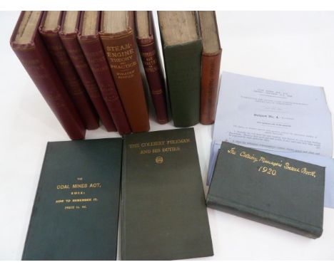
Coal Mining interest including:-"The Colliery Manager's Pocket Book" 1920, with advertisements, diary is unused, green cloth with gilt titles on the front boardO'Donoghue, T A"Field and Colliery Surveying" 1914, illustrations and plansJevons, H Stanley"The British Coal Trade, 2nd impression with appendix of recent statistics" Kegan, Paul, Trench Trubner 1920, folding colour map, frontis, photographic illustrations, folding plan, green cloth, blindstamped titlesPenman, David "Compressed Air Practice in Mining" 1922"The Coal Mines Act 1911: How to Remember It", green cloth, gilt title"The Colliery Fireman and his Duties", ndRipper, William "Steam Engine Theory and Practice", Longmans Green & Co 1922, inserted in this is "The Danger of the Presence of Carbon Monoxide in Stagnant Gas - A Paper dated Saturday April 30th 1927" Redmayne, Sir R A S"Modern Practice in Mining", Longmans Green & Co 1919, in four volumes, uniform bound red cloth with blindstamped titles (11)
Lot 19
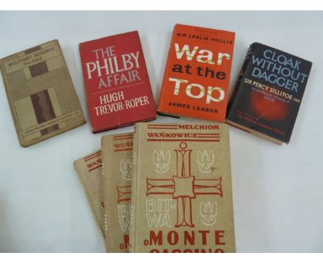
Sillitoe, Sir Percy"Cloak Without Dagger", Cassell & Company 1955, photographic portrait frontis, red cloth, dj not price clipped but repairedLeasor, James "War at the Top - based on the experiences of General Sir Leslie Hollis", Michael Joseph 1959, signed on the ffep ' Leslie Hollis April 1959', photographic illustrations, edges foxed and stained, black cloth, gilt titles, dj not price clippedTrevor-Roper, Hugh "The Philby Affair", William Kimber 1968, maroon cloth with pastedown titles to the backstrip, dj not price clipped, pen signature on ffepPortway, Lieut Colonel Donald "Military Science Today", Oxford University Press, nd, part of the Pageant of Progress series, photographic illustrations, folding map, some foxing to edges, pictorial cloth, spine fadedWankowicz, Melchior "Bitwa O Monte Cassino", RZYM 1947, 3 volumes, pictorial cloth, photographic illustrations Lawrence, T E "Seven Pillars of Wisdom - a Triumph", Jonathan Cape 1935, frontis portrait, numerous plates, name in pencil on ffep, brown cloth, gilt decorations, dj not price clipped but loss to the front coverWoolley, C Leonard and Lawrence, T E"The Wilderness of Zin", Jonathan Cape 1936, brown cloth, gilt titles, dj not price clipped (8)

Lot 21
Motor Racing interest: McLaren, Bruce"From the Cockpit", The Motor Aces Book Club, Frederick Muller 1965, brown cloth with damp damage, dj (damaged)Chambers, Marcus"The Seven Year Twitch", The Motor Aces Book Club, G T Foulis & Co, London 1965, photographic ills, map on ep, blue cloth, dj, assorted photographs of motor cars"Nelson - Racing Cars", pictorial boardsWaddington's Car Racing game Formula I Decca Record"Le Mans 66", the 34th Grand Prix D'Endurance June 18 & 19 1966 with the voices of Bruce McLaren, Graham Hill, Chris Amon and Carroll Shelby and the voices of the public, commentary by James Tilling

Lot 23
Tollemache, Lord"Croquet", Stanley Paul & Co 1914, photographic ills, maps, plans, game plans and counters in slip case on back board, dj, green cloth with gilt titles, there are 6 folding plans and 12 countersFletcher-Watson, James"Soldier Artist in Wartime India 1941-1945", signed by the artist on title page, pub 2000 by Country Heritage, map on ep, memorial service sheet for James Fletcher-Watson Thursday 9th September 2004, maroon cloth, dj not price clipped, oblong folio and seven Penguin Scores including Schubert, Haydn, Mozart, Mendelssohn and Brahms (9)

Lot 31
The River Thames interest including:-"Rivers of Great Britain, The Thames from Source to Sea", Cassell & Co nd, numerous ills and plates throughout, green cloth with gilt titles, small folioArnot Robertson, E and Turner, H E"Thames Portrait", Ivor Nicholson & WatsonGodlee, Sir Rickman J "A Village on the Thames, Whitchurch, Yesterday and Today", George Allen & Unwin 1926, photographic portrait of R J Godlee in the garden 1923, various photographic illsWilliams, Alfred "Round About the Upper Thames", Duckworth & Co 1922, photographic frontis, map, green cloth, gilt titlesHarper, C G "Thames Valley Villages", Chapman & Hall, 2 volsLeyland, John"The Thames Illustrated, a Picturesque Journeying from Richmond to Oxford", Geo Newnes, numerous photographic ills, pictorial cloth and other related volumes (1 box)
Lot 46
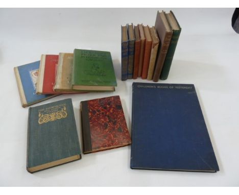
Quantity of children's books including:-Lang, Andrew (ed) "The Snow Queen and Other Stories from the Pink and Crimson Fairy Books", ills Henry J Ford, Longmans Green & Co 1906, colour frontis, black and white plates, some foxing throughout, decorated ep, grey cloth, gilt titles and decorations to backstripThackery, W M"The Rose and the Ring ...", Smith Elder & Co 1902, ills, inscription on ffep dated 1905, pictorial grey cloth and gilt titlesStevenson, Robert Louis "Treasure Island", Cassell & Co 1883, map frontis, tissue guard, original green cloth with gilt titles to backstrip, corners and edges bumped and rubbed, binding loose, some foxing (the story first book edition as originally it was serialised in the children's magazine 'Little Folks') Barrie, J M "Peter Pan in Kensington Gardens retold for Little People ...", pictures by Arthur Rackham, Hodder & Stoughton 1939, hinges cracked, green cloth with black titlesAshford, Daisy"The Young Visitors or, Mr Salteena's Plan", Chatto & Windus 1919, photographic portrait frontis, small 8vo, marbled boards, cloth backstrip with pastedown title"The Studio Special Autumn Numbers Children's Books of Yesterday" by Philip James 1933, advertisements, ills throughout, small folio, blue cloth, silver titles, rather rubbedCarroll, Lewis "Alice's Adventures in Wonderland", John Tenniel ills, Macmillan & Co 1912"Phantasmagoria and other Poems", ills by Arthur B Frost, Macmillan & Co 1911, bkpl inside front board, ffep with offsetting, red cloth, some damp damage, gilt titles "The Hunting of the Snark ...", ills by Henry Holiday, Macmillan & Co 1910, red cloth, gilt titles, shelf ware and faded Carroll, Lewis"Through the Looking Glass", ills by John Tenniel, Macmillan & Co 1935, red cloth, edges stained, djGrahame, Kenneth"Dream Days and the Golden Age", Thomas Nelson & Sons, frontis to each vol, blue decorated cloth, gilt titles to backstrip, hinges cracked, t.e.g. Brooke, L Leslie (drawn by) "Johnny Crow's Garden, a picture book""Johnny Crow's Party, another picture book", Frederick Warne "Johnny Crow's New Garden", Frederick Warne 1935, colour plates, ills, all three books have been scribbled in in pencil, pictorial pastedown to front boards (15)

Lot 66
Tolkien, J R R "The Hobbit or There and Back Again", George Allen & Unwin 1956, colour frontis, ills by the author, map, ep, address sticker inside front board and name written in biro, dj clipped but not price clippedTolkien, J R R "Poems and Stories", George Allen & Unwin 1980, ills by Pauline Baynes, marbled ep, black cloth with gilt and green tree on front board, gilt titles, speckled edges (2)


Lot 279
Local History. Bardsley, Charles W. - Chronicles of the Town & Church of Ulverston. James Atkinson: 1885. With real photo illustrations. Original full vellum, gilt. Soiled. With; [West, T.] - Antiquities of Furness. London: 1774. With folding map, ground plan and view of the Abbey. Plain cloth rebind. With; 1 other related title. (4) Provenance: Barrow Library, the Bardsley and West appear to have been spared any bookplates or obvious stamps.

Lot 535
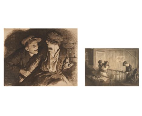
Two (2) pieces early 20th century illustration art, including paintings by M. Leone Bracker and Worth Brehm. 1st item: M. Leone Bracker (American, 1885-1937) charcoal on board framed and matted illustration titled "The Black Cap" depicting a shadowy scene of a man grasping the arm of a startled young woman in front of a brick wall. Signed and dated "M. Leone Bracker 1919-" lower left. Dated "January 1920" in pencil en verso. Housed in a molded gilt wood frame. Sight - 27 1/2" H x 35 1/2" W. Framed - 35 1/4" H x 43 1/2" W. 2nd item: Worth Brehm (Indiana, 1883-1928) charcoal and graphite on paper illustration titled "The Struggle," depicting an early 20th century interior scene in which a young boy in a newsboy cap restrains a brunette girl while another boy looks at money in his hand, fore and middle ground, a map of Indiana and a handwritten sign reading "OFFICE OF ATWATER AND ROOTER" on the wall in the background. Signed "Worth Brehm" lower left. Housed under glass in a giltwood frame with off white linen mat with giltwood liner. Sight - 17 1/4" H x 24 1/2" W. Framed - 25 1/4" H x 32 3/4" W. Both items early 20th century. CONDITION: 1st item: Overall good condition. Minute foxing and toning. Minor staining to top left corner, partially obscured by matting, roughly 1 1/2" L x 3/4" W. Two repaired tears with slight discoloration in lower left quadrant along left edge, largest 6" L and partially obscured by matting. Not examined outside of frame. 2nd item: Overall good condition. Few errant white marks, largest 1/8" to surface of sheet. Not examined outside of frame.
Lot 581
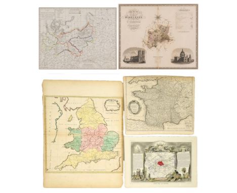
Five (5) European maps, including French Napoleonic and English. 1st item: Map of Theater of War and French and Allied Saxon Marches in Prussia and Poland during the Campaigns of 1806 and 1807 (Carte de Theatre de la Guerre et Marches des Armees Francaises et Allies en Saxe en Prusse et en Pologne pendant les Campagnes de 1806 et 1807) engraved by Jean Baptiste Pierre Tardieu, circa 1807. Copper plate engraving depicting the areas of Europe involved in the Napoleonic War of the Fourth Coalition, October 1806-July 1807, including with hand colored elements detailing the routes of the different armies with French text. Title and tables, top left and center, scale of miles, lower center. Map surrounded by scale notations and double line border. Previously mounted to mat with old archival paper tape. Image - 16 3/8" H x 20 5/8" W. Sheet - 17 7/8" H x 22 1/2" W. Mat - 23 3/8" H x 27 1/4" W. 2nd item: The County of Middlesex, from an Actual Survey made in the Years 1819 & 1820 by C. & I. Greenwood, engraved by J. & J. Neele, 1829. Published by the proprietors C. Greenwood & Co., London. Copper plate engraving with hand coloring depicting Middlesex, a historic county in southeast England almost entirely within the wider urbanized area of London, center, with vignettes of Westminster Abbey, lower left, and St. Paul's Cathedral, lower right. Title, top left, compass rose, top center, Explanation and scale of miles, top right, Reference to the Hundreds, lower center. Map surrounded by border with scale notations. Housed in a mat with plastic covering. Image - 21" H x 25 3/4" W. Sight - 21 1/4" H x 26" W. Mat - 26 7/8" H x 32 3/8" W. 3rd item: "Carte D'Angleterre 1754" by Jean Palairet. Colored map of England and Wales with French identifications. Counties, cities, towns, rivers, bodies of water, and points of interest marked. Ireland, Scotland, and France also present. Decorative title cartouche with scale of miles, top right. Image - 20-1/4" H x 20-5/8" W. Sheet - 28-3/4" H x 21-1/4" W. 4th item: "A Map of France with the Dominions" by Richard William Seale, for "Mr. Tindal's Continuation of Mr. Rapins History", 1750. Uncolored map of France and surrounding territories, including parts of England, Germany, and Spain, with regions, cities, towns, rivers, bodies of water, mountain ranges, and points of interest marked. Decorative title cartouche, middle left. Explanation and 2 scales of miles, lower right. Image - 15" H x 18-1/2" W. Sheet - 16" H x 19-1/4" W. 5th item: "Dept de la Seine" by Victor Levasseur, engraved by Laguillermie and Rainaud, for "Atlas National Illustre des 86 Departments et des Possessions De La France", 1833. Colored map of Paris, with surrounding regions, including Versailles, some colored elements. Surrounding map are sections of text describing statistics, curiosities and celebrities, and products and commerce. Images of local heroes, products, landscapes, dress, and coat of arms with colored elements above and below map. Image - 12" H x 17-3/8" W. Sheet - 14-1/8" H x 20-1/8" W. All items mid 18th/second quarter 19th century. CONDITION: 1st item: Overall good condition with foxing spots, tears. Residue from old archival paper tape to each corner. Sheet has been cut down. 2nd item: Overall good condition with toning/areas of acid burn, foxing spots. Not examined outside of mat. 3rd item: Impression of other map visible lower right. Areas of toning on surface, largest area 1/2", lower middle left. Slight toning around edges. Loss, rips, tears, to edges of sheet. 4th item: 1-5/8" line of toning, top left. Slight toning around edges, toning extends 1-5/8" on top edge. 5th item: 2 brown stains, 3/8" top middle right, and 1/8" middle left. Slight toning around edges.
Lot 582
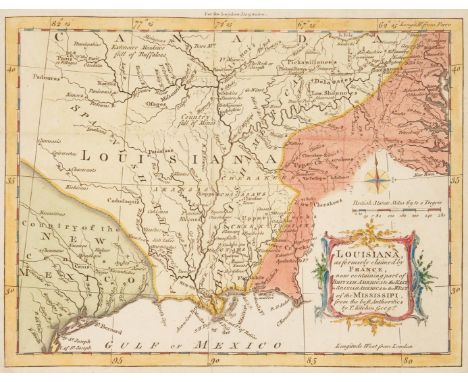
Louisiana, as formerly claimed by France, now containing part of British America to the East in Spanish America to the West of Mississippi map, by Thomas Kitchin, published in the London Magazine, for R. Baldwin, Vol. 34, opp. pg. 276, June 1765. Copper plate engraving with hand coloring depicting the Louisiana territory, center, and the surrounding areas including the Country of New Mexico, lower left, and Native American territory, including Cherokees and Creeks, designated as "Upper Cherakees [sic]", "Lower Cherakees [sic]", "Upper Creeks", and "Lower Creeks", along with other tribes, right. Cities and towns, including New Orleans, bodies of water, and other points of interest including "Country full of Mines" are labeled. Compass rose, scale of miles, and title cartouche, lower right. Map surrounded by scale notations and line border. Secured to a mat with two pieces of white archival tape, top left and right edge. Sheet - 8 3/8" H x 9 5/8" W. Sight - 7 1/4" H x 9 3/8" W. Mat - 11 1/8" H x 13 3/4" W. Third quarter 18th century. CONDITION: Light toning, few minute foxing spots. Few tears, largest 1/4", to fold lines. Two areas of loss, largest 1 1/4" x 1/4", to corners of sheet. Pencil inscription en verso. David Lloyd Swift ink stamp indicates that the map was professionally deacidified in March 1998.

Lot 583
Map of the State of Texas, by James Hamilton Young, engraved by J.L. Hazard, published in A NEW UNIVERSAL ATLAS, Charles Desilver, Philadelphia, 1856. Steel plate engraving with hand coloring depicting the territory of Texas, center, and the surrounding areas including Mexico, lower left, and the Indian Territory, Arkansas, and Louisiana, top right. Cities and towns, including Austin and Houston, railroads, bodies of water, counties, and other points of interest including Apache, Comanchees, and Lippan lands, important battlefields in both the Texas Revolution and the Mexican-American War, are labelled. Inset maps of Northern Texas and Map of Galveston Bay, top and lower left. List of railroads, title, and scale of miles, lower right. Explanation and population tables listed by race, center left. Map surrounded by scale notations and a decorative border. Photocopy of the atlas cover, en verso. Encapsulated (not laminated) in a plastic archival sleeve. Sheet - 13 3/4" H x 16 3/4" W. Sleeve - 14 1/2" H x 17 5/8" W. Mid 19th century. CONDITION: Light toning/acid burn, few minute foxing spots visible en verso. David Lloyd Swift label indicates that the map was professionally deacidified on March 14, 1989.
Lot 584
Two (2) Southern Maps. 1st item: Abraham Bradley, Jr. (American, 1767-1838), MAP OF THE SOUTHERN PARTS OF THE UNITED STATES OF AMERICA, engraved for The American Gazetteer by Jedidiah Morse, published by S. Hall, Boston, 1797. Copper plate engraving with hand coloring of the Southern United States and Native American territories east of the Mississippi River including Part of Kentucky, Part of Virginia, Tennessee, North Carolina, Georgia Western, South Carolina, Chactaws [sic] Territory Georgia, West Florida, and East Florida, prior to the establishment of Mississippi and Alabama in 1817 and the Louisiana Purchase. Cities from Norfolk to St. Augustine, towns, districts, including the Mero District near Nashville, bodies of water, and other areas of interest, including the locations of Native American tribes, including the Upper Creeks and Cherokees in eastern Kentucky, are labelled. Title and scale of miles, center to lower right. Map surrounded by scale notations and a line border. Encapsulated (not laminated) in a plastic archival sleeve and secured to a mat. Sight - 8 1/8" H x 15 1/4" W. Mat - 14 1/4" H x 20 1/4" W. Late 18th century. 2nd item: John Bartholomew (Scottish, 1831-1893), KENTUCKY AND TENNESSEE, drawn and engraved by John Bartholomew, for Black's Atlas of North America, published by Adam and Charles Black, Edinburgh, 1856. Steel plate engraving with printed coloring depicting Kentucky and Tennessee and the surrounding areas with cities and towns, including Nashville and Knoxville, counties, bodies of water, roads, and other areas of interest labelled. Title and scale of miles, top left. Map surrounded by scale notations and triple line border. Encapsulated (not laminated) in a plastic archival sleeve and secured to a mat. Sheet - 12 1/4" H x 16 3/4" W. Mat - 18 3/8" H x 24 3/8" W. Mid 19th century. CONDITION: 1st item: Areas of toning/acid burn, foxing spots, largest 1/2". 1/4" x 2 1/2" area of loss, lower right corner of sheet. Areas of tape repair, largest 1 3/4" x 3/4", visible en verso. Possible pencil inscriptions en verso. Map with paper backing. David Lloyd Swift label indicates that the map was professionally encapsulated, cleaned, and deacidified in 1998. 2nd item: Areas of toning, minute foxing spots. Pencil inscriptions, en verso. David Lloyd Swift ink stamp label indicates that the map was professionally deacidified.

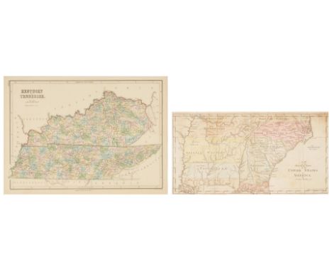
Lot 585
THE STATE OF VIRGINIA map, engraved by Benjamin Tanner, for The American Atlas, published by John Reid, New York, 1796. Copper plate engraving with hand coloring depicting an early map of Virginia with cities and towns, including Richmond, counties, roads, rivers, lakes, islands, harbors, bays, court houses, along with topographical details labelled. Title cartouche and scale of miles, top left. Map surrounded by scale notations and triple line border. Encapsulated (not laminated) in a plastic archival sleeve and secured to a mat. Plate - 14 1/4" H x 19 1/2" W. Sheet - 16 3/8" H x 20 1/8" W. Sight - 15" H x 19 3/4" W. Mat - 20" H x 26" W. Late 18th century. CONDITION: Overall good condition with toning, foxing spots, largest 1/4". David Lloyd Swift ink stamp label indicates that the map was professionally deacidified.
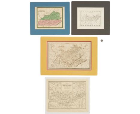
Lot 586
Two (2) Maps of Tennessee, two (2) maps of Tennessee and Kentucky, 4 items total. 1st item: Tennessee map, from American Pocket Atlas, published by Mathew Carey, Philadelphia, 1816. Copper plate engraving depicting Tennessee, center and surrounding areas, with cities and towns, including Knoxville, Clarksville, and Nashvill [sic], roads, bodies of water, and other points of interest, including Cragfont, the Home of General James Winchester, labelled. Title and scale of miles, top center. Map surrounded by scale notations and line border. Encapsulated (not laminated) in a plastic archival sleeve and secured to a mat. Plate - 6 5/8" H x 8 1/2" W. Sheet - 8 5/8" H x 10 5/8" W. Sight - 8 1/8" H x 10 1/8" W. Mat - 13" H x 14 5/8" W. 2nd item: Kentucky and Tennessee map, believed to be by David H. Burr, from The American Atlas, published by John Arrowsmith, London, 1839. Copper plate engraving with hand coloring depicting Kentucky and Tennessee and surrounding areas, with cities and towns, including Knoxville, Nashville, and Frankfort, roads, bodies of water, and other points of interest labeled. Title cartouche, top left. Surrounded by scale notations and a decorative border. Encapsulated (not laminated) in a plastic archival sleeve and secured to a mat. Sheet - 8 3/4" H x 11 3/4" W. Sight - 8 1/2" H x 11 1/4" W. Mat - 12 1/2" H x 15 1/8" W. 3rd item: Map of the States of Kentucky and Tennessee, engraved and printed by Fenner and Sears Company, from The History and Topography of the United States, J.H. Hinton, ed. London: I.T. Hinton and Simpkin & Marshall, Vol. 1, facing pg. 421, 1831. Copper plate engraving depicting Kentucky and Tennessee and the surrounding areas with cities and towns, including Knoxville, Lexington, and Nashville, with Murfreesboro listed as the capital of Tennessee, roads, bodies of water, and other points of interest labelled.Title and scale of miles, top left. Surrounded by scale notations and a triple line border. Encapsulated (not laminated) in a plastic archival sleeve and housed in a double mat. Sight - 10 1/4" H x 16" W. Mat - 14 3/4" H x 21 5/8" W. 4th item: A New Map of Tennessee, engraved by J. and W. W. Warr, from A New Universal Atlas by Henry S. Tanner, published by Carey and Hart, Philadelphia, 1841. Copper plate engraving depicting Tennessee and the surrounding areas with cities and towns, including Knoxville, Clarksville, and Nashville, roads, bodies of water, and other points of interest labelled. Two inset maps of Nashville and Knoxville, top left and right. Title and scale of miles, top center, explanation, lower left, Steam Boat Routes tables, lower right. Surrounded by scale notations and a triple line border. Encapsulated (not laminated) in a plastic archival sleeve. Plate - 12 3/8" H x 15 1/4" W. Sheet - 12 7/8" H x 16" W. Sleeve - 14 1/8" H x 17 1/4" W. All items first half of 19th century. CONDITION: All items in overall good condition with light toning/acid burn, minute foxing spots. 1st item: Pencil inscription en verso. 2nd item: Toning impressions visible en verso. David Lloyd Swift label indicates that the map was professionally encapsulated, cleaned, and deacidified on February 3, 1998. 3rd item: Toning impressions to surface of sheet. David Lloyd Swift label indicates that the map was professionally encapsulated, cleaned, and deacidified on November 1, 1989. 4th item: Pencil inscriptions, lower right of sheet. Areas of loss, largest 5/8" x 1 1/8", to sheet. David Lloyd Swift label indicates that the map was professionally encapsulated, cleaned, and deacidified on February 13, 1998.

Lot 587
A MAP OF THE STATES OF VIRGINIA, NORTH CAROLINA, SOUTH CAROLINA, AND GEORGIA by Joseph Purcell, engraved by W. Harrison, for Morse's Geography by Jedidiah Morse, published by John Stockdale, London, 1792. Rare copperplate engraved map showing the "State of Franklin" - which would later become East Tennessee- and Nashville within the state of North Carolina, surrounded by Southern States, including Maryland, Virginia, Georgia, South Carolina, and West and East Florida, with Louisiana Spanish territory, left, and "New States," above. Cities, from Baltimore to St. Augustine, towns, counties, bodies of water, and other areas of interest, including the locations of Native American tribes, including the Cherokee Northeast Georgia, Indian Trade paths, the Seven Ranges, Ekanfanoka Swamp (Okefenokee), Port Vincient (Vincennes), The Ohio Company, New Jersey Company and Illinois Company Lands, the Donation Lands of the Commonwealth of Virginia, are labelled. Title, lower right, explanation and scale of miles, top right. Map surrounded by scale notations and a line border. Encapsulated (not laminated) in a plastic archival sleeve and secured to a mat. Plate - 13" H x 15 1/8" W Sheet - 15 3/8" H x 17 5/8" W. Sight - 13 3/4" H x 16 1/4" W. Mat - 20 1/4" H x 27 1/4" W. Late 18th century. CONDITION: Overall good condition with toning, minute foxing spots. Areas of white archival tape repair, largest 17 1/2" x 1", primarily to fold lines, visible en verso. David Lloyd Swift label indicates that the map was professionally encapsulated, cleaned, and deacidified in 1994.

Lot 589
PLAT BOOK OF NASHVILLE, TENNESSEE, 1925, S.M. Murray Engineering Company. Contains 115 black and white plates of survey maps of Nashville TN showing roads, subdivisions, and various landmarks. Includes index. Cloth covered boards with leather title plaque; each plat map backed with linen. Also includes several loose items stuck into the pages such as a blueprint of "Alvin Foster's Sleepy Hollow Farm" in neighboring Williamson County, a survey map of the H.C. Ezell land on Mill Creek, a printed map of Corinne Place on J.K. Rain's land dated 1906, and 2 mass produced National Geographic maps. Plat book - 2" H x 23" W x 19" D. Provenance: the estate of Victor T. Patterson, Franklin, TN. Note: born in Georgia and educated at the Parsons School of Design, Victor Patterson served as a cultural representative to Russia with Dwight D. Eisenhower's "People to People" program (prior to its privatization) before moving to the Nashville, Tennessee area to pursue a career in interior design. He was associated with Bradford's for many years before starting his own business. He decorated the Tennessee Governor's Mansion and the home of several country music stars in the 1970s, and filled his home on Franklin's historic Fourth Avenue with art and antiques from his frequent travels. CONDITION: Wear and staining to cloth covers. Some pages with light dampstaining to outer corners, some with extraneous pencil marks, all with some light toning.
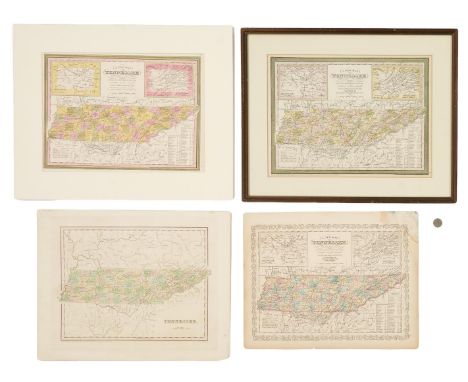
Lot 590
Four (4) 19th Century Tennessee Maps, incl. Thomas G. Bradford, 1838. 1st item: "Tennessee" Map by Thomas G. Bradford, engraved by George W. Boynton, 1838. From "A Comprehensive Atlas, Geographical, Historical & Commercial" by Thomas G. Bradford. Copper plate engraving with hand-coloring of Kentucky and Tennessee depicting towns and roads, county lines, names of counties, rivers, and mountains. Title and scale of miles, lower left. "Longitude West from Washington", centered below map. Map surrounded by scale notations and triple line border. Image - 11 1/4" H x 15" W. Sheet - 14 3/4" H x 18 7/8" W. 2nd item: "A New Map of Tennessee" by Samuel A. Mitchell, engraved by H. N. Burroughs, published by Samuel A. Mitchell, Philadelphia, 1846. From "A New Universal Atlas" by Samuel A. Mitchell. Lithographic engraving with hand coloring of Tennessee depicting towns and roads, county lines, names of counties, rivers, and mountains. Includes inset maps of the "Environs of Nashville", top left, and the "Environs of Knoxville", top right. Title and scale of miles, top center, explanation, lower left, distance tables, lower right. "Longitude West from Washington", centered above map. Map surrounded by scale notations and "Cary and Hart" border. Mounted to mat. Image - 11" H x 15" W. Sheet - 14" H x 17 1/4" W. Mat - 17" H x 21 1/8" W. 3rd item: "A New Map of Tennessee" by Samuel A. Mitchell, published by Thomas, Cowperthwait and Company, Philadelphia, 1855. From "A New Universal Atlas" by Samuel A. Mitchell. Lithographic engraving with hand coloring of Tennessee depicting towns and roads, county lines, names of counties, rivers, and mountains. Includes inset maps of the "Environs of Nashville", top left, and the "Environs of Knoxville", top right. Title and scale of miles, top center, explanation, lower left, distance tables, lower right. "Longitude West from Washington", centered above map. Map surrounded by scale notations and decorative border. Housed in wooden frame with mat. Image - 11 1/4" H x 15 1/4" W. Sight - 12" H x 16" W. Framed - 16 3/4" H x 20 7/8" W. 4th item: "A New Map of Tennessee" by Samuel A. Mitchell, published by Charles DeSilver, 1857. From "A New Universal Atlas" by Samuel A. Mitchell. Lithographic engraving with hand coloring of Tennessee depicting towns and roads, county lines, names of counties, rivers, and mountains. Includes inset maps of the "Environs of Nashville", top left, and the "Environs of Knoxville", top right. Title and scale of miles, top center, explanation, lower left, distance tables, lower right. "Longitude West from Washington", centered above map. Map surrounded by scale notations and fretwork border. Image - 11 1/2" H x 15 1/4" W. Sheet - 13 1/2" H x 17 1/4" W. All items American, early/mid 19th century. CONDITION: 1st item: Ghost tape mark, top right of sheet. Toning around edges of sheet. 1 1/4" tear, lower right corner. Black scuffs, largest 3/4", surface of sheet. Toning, visible en verso. 2nd item: Toning around edges of sheet. 3/8" hole top right of sheet. Minute foxing spots visible en verso. 3rd item: Toning visible around inside edge of matte. 1/4" toning spot, top left of map. Not examined outside of frame. 4th item: 5" area of water damage, top right corner. Slight toning around edges of sheet. Minute foxing spots on surface of map. 1/4" tear lower center edge of map. Toning, foxing spots visible en verso.

Lot 594
HISTORIC PLACES IN TENNESSEE, a bound collection of photographs, prints and maps compiled by the Tennessee Society of the Daughters of the Revolution (DAR) for the Tennessee room of the DAR Headquarters, Memorial Continental Hall, in Washington, D.C., with seven gelatin silver prints by noted Nashville photographer Marvin Willard Wiles (1882-1957) and hand printed text and hand painted enhanced capital letters with vignette illustrations by Haywood Norman. Title page reads: "Historic Places in Tennessee, Selected and Presented to the Tennessee Room, Memorial Continental Hall, by Penelope Johnson Allen, State Historian, Tennessee Daughters of the American Revolution, November 1923. Inscriptions and Decorations by Haywood Norman". The book is comprised of thirty (30) photographs, illustrations, and two (2) maps, all relating to Tennessee history, each with handwritten information text pages and enhanced capital letters by Norman. Wiles' photographs include images of the front and rear of the Hermitage, Cedar Lane, the gateway to the Hermitage, The Original Hermitage, Belle Meade, the Parthenon, and The Tennessee State Capitol building. Other notable sites and images featured include a facsimile of The Timberlake Map, Tennessee's first "authentic" map, the first church building in TN, President Andrew Johnson's Tailor Shop, Jonesboro, The Boone Tree, John Sevier's Church, and the Cumberland Gap. Housed in a leather bound portfolio with marbleized end pages; wooden title placard to the front cover with hand painted Tennessee state seal. 12" H x 11 3/4" W x 2" D. Biography: Marvin Willard Wiles, son of Mary Elizabeth (nee Cruzen) and Henry G. Wiles, was born in Hagerstown, Washington County, Maryland. He may have spent some of his childhood in Florence, Alabama, where his father had a business, and reportedly moved to Nashville, Tennessee, in 1895. "M. W. Wiles" and Lessie J. Hood were married on 19 May 1903 in Davidson County, Tennessee. City directories for Nashville through 1908 show him employed as a clerk or salesman, and beginning in 1909 as a photographer. Marvin Wiles opened a photography studio in Nashville in 1910, and took pictures for local newspapers, covering events such as Woodrow Wilson's inauguration and the return of soldiers from WWI. Marvin Wiles entered a partnership with Steve Hood in 1940, creating the Wiles-Hood Studio, and retired in 1954. The Tennessee State Library and Archives has a collection of 60 photographs taken by Marvin Wiles in and around the Nashville area. (source: https://www.findagrave.com/memorial/67955265/marvin-willard-wiles). CONDITION: Cover with overall general wear and losses, chipping to the edges, spine partially detached. Some light shedding. Interior overall good condition with light toning and wear.
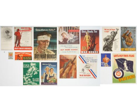
Lot 627
Twelve (12) World War II United States propaganda posters by artists including John Atherton and Steve Broder. 1st item: Poster depicts a male soldier wearing a green helmet looking up while raising a United States flag on a pole. Text, in white across bottom left reads "To Have and to Hold!" and in large, red capital letters at the bottom "War Bonds". Published by the U.S. Government Printing Office, 1944, and reads "Official U.S. Treasury Poster" across the bottom. Unframed. 28" H x 20" W. 2nd item: Poster depicts a black and white photograph of a lady's hands, wearing a wedding ring, and knitting a baby sock. Red, white, and blue stripes run diagonally from top left to bottom right behind black text that reads "For the Future – Worth Fighting For …… Worth Saving for! – Buy More War Bonds through the Pay Roll Savings Plan during the Third War Loan Campaign." Published by the U.S. Government Printing Office, 1943. Text at bottom reads "Interdepartmental War Savings Bond Committee." Number "8" stamped in black and "Enclosure" stamped in purple en verso. Unframed. 28" H x 22" W. 3rd item: Poster depicts a large color illustration of the Concord Minuteman statue with a colonial town scene in the background, including a church, town hall with clock tower, trees, and silhouettes of people walking. Blue text at top reads "For Freedom's Sake" and in all capital red letters at bottom "Buy War Bonds". Signed "JA" in bottom right for artist John Atherton.Unframed. 28" H x 22" W. 4th item: Poster titled "New Air Raid Warning System" in all outlined white all-capital letters at the top, with light blue background and navy blue, red, and white text and graphics. Text describes different signals, their meanings, and mandated civilian actions in the event of an air raid in the United States. Published by the U.S. Government Printing Office, 1943. Text at bottom reads "Approved by the U.S. Office of Civilian Defense, The Eastern Defense Command, and the First Army." Unframed. 20" H x 28" W. 5th item: Poster titled "The Greatest Investment on Earth!" on a white background depicts red, white, and blue stripes running on a diagonal from the top left to bottom right corners, with a $25 war bond with a stone house in the middle of it, superimposed over a map of the contiguous United States, while a black and white illustration of a smiling husband and wife with their two children stand in the lower left. Text at bottom reads in all capitals "For Your Country…. Yourself….Your Family – War Bonds – Through The Pay Roll Savings Plan!" Published by the U.S. Government Printing Office, 1943. Unframed. 28" H x 22" W. 6th item: Poster titled "The United Nations Fight for Freedom" in white letters against a black background depicts the Statue of Liberty in white, in the lower left corner with her arm raised along the left side. The flags, in full color, of the thirty (30) countries of the United Nations are depicted with the name of each country in white text below its flag. Artist's name "Broder", for Steve Broder, appears at the center bottom. Published by the U.S. Government Printing Office, 1942. Unframed. 28" H x 22" W. 7th item: Poster depicts a subdued color scene with a deceased sailor in a blue uniform with white trim lying on a beach in the surf and a sunset sky, against a black background, with text below that reads "a careless word… – A Needless Loss." Artist's name printed below the picture "Anton Otto Fischer." Published by the U.S. Government Printing Office, 1943. Unframed. 28" H x 22" W. (for the full description and condition report, please visit our website at http://www.caseantiques.com).
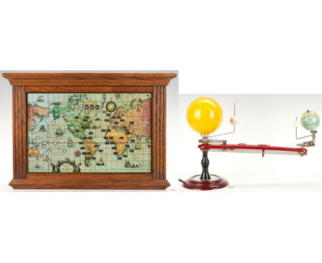
Lot 634
Trippensee Planetarium Co. Tellurian Model, Howard Miller Lighted World Map Electric Clock, 2 items total. 1st item: Trippensee Planetarium Company, Saginaw, Michigan, geared Tellurian model, manufactured by the George F. Cram Company. Comprised of painted wood or dense plastic globes representing the Earth, Moon, and Venus affixed to metal rod arms that revolve around a central yellow dense plastic sphere containing a lightbulb representing the sun on a maroon colored dense plastic arm with an inset compass, all mounted on a turned ebonized wooden pillar, set on a stepped round maroon colored dense plastic base, with a circular zodiac dial to the top, printed in black on silver. Iron weight on the underside of the base is stamped "1966." Maker's marks to maroon arm. Wired for electricity. 13 3/4" H x 20" W x 7 1/2" D. 2nd item: Howard Miller Clock Company lighted world time zone map electric clock, model 612-371, serial number 81830859. Comprised of a chromolithographic labeled world map printed to reverse of glass with open slots exposing different time zones of major cities around the world with slots for local time top center, all housed in an oak case. Cartouche with title, maker, scale of miles, copyright date "1959", and patent information, lower right. Informational paper label en verso. Wired for electricity with button switch, top of case. Glass map - 12 5/8" H x 19 1/2" W. Case - 18" H x 26 1/3" W. 5 1/2" D. Both items mid 20th century. CONDITION: 1st item: Overall good condition with surface wear, scuffs to globes. Gears, rotating parts on working condition. Electrical parts are functional. 2nd item: Overall good condition. Lighting mechanism was in working condition when tested. Few areas of loss, largest 3/4", to case.

Lot 650
Four (4) Tennessee history, furniture, and early material culture-related books. 1st item: THE ART AND MYSTERY OF TENNESSEE FURNITURE AND ITS MAKERS THROUGH 1850, by Nathan Harsh and Derita Coleman Williams, published by the Tennessee Historical Society, Nashville, 1988. Octavo, 344 pages with photographic illustrations, hardbound in brown cloth with gilt blind stamp to front cover, gilt lettering to spine, marbled endpapers. Includes original dust jacket. 11 1/4" H x 8 3/4" W. 2nd item: HISTORY OF TENNESSEE, East Tennessee edition, illustrated, published by The Goodspeed Publishing Company, Nashville and Chicago, 1889. Octavo, 1317 pages, 41 illustrations, hardbound in three-quarter dark red leather with grey cloth sides, with gilt blind stamp to front cover, gilt lettering to spine, five raised hubs, floral endpapers. Covers wrapped in brown paper. 10 1/4" H x 7 1/4" W x 4 1/4" D. 3rd item: THE ANTIQUITIES OF TENNESSEE AND THE ADJACENT STATES, Second Edition, by Gates P. Thruston, published by The Robert Clarke Company, Cincinnati, 1897. Octavo, 369 pages with black and white illustrations, hardbound in green cloth with gilt blindstamp to front cover and gilt lettering to spine, floral endpapers. 10" H x 7 1/4" W x 1 1/4" D. 4th item: HISTORY OF TENNESSEE, ITS INSTITUTIONS AND ITS PEOPLE, by William Robertson Garret and Albert Virgil Goodpasture, Brandon Printing Company, Nashville, 1900. Octavo, 351 pages with black and white illustrations, hardound in grey cloth boards with blind stamped covers and black lettering to spine. 8 3/4" H x 6 1/2" W x 1" D. Provenance: Estate of Anne Harrison Taylor & Joseph F. Taylor, Morristown, TN. CONDITION: 1st item: Overall good condition. Tears, largest 5/8", to corners of dust jacket. 2nd item: Bumped corners, wear to covers and spine. Pages almost completely separated from spine. Pages with tears, toning, foxing sports, acid burn, ink and pencil inscriptions, etc. All illustrations collated except for frontispiece map (missing). Pages 427, 428, 425, and 426 are out of order. 3rd item: Bumped corners, wear to covers and spine. Toning, foxing spots, to pages. Front end paper and frontispiece, pages 215-218 separated from spine. Old scotch tape repair to front endpaper. 4th item: Slightly bumped corners, wear to covers and spine. Toning to pages.
-
109198 item(s)/page