We found 109198 price guide item(s) matching your search
There are 109198 lots that match your search criteria. Subscribe now to get instant access to the full price guide service.
Click here to subscribe- List
- Grid
-
109198 item(s)/page


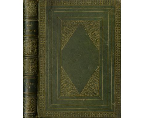
Lot 197
In Fine Bindingde Cervantes Saavedra (M.) El Ingenioso Hidalgo don Quixote de la Mancha, Nueva Edicion Corregida Por La Real Academia Espanolo. 4 vols. lg. 4to Madrid 1780. First Royal Spanish Academy Edition, engd. port. frontis Vol. I, 4 engd. add. titles, fold. engd. map, engd. head & tails etc., & 28 full page plts., a.e.g. in cont. full straight grained green mor. lg. gilt tooled borders, line decorated panels, including lg. central panel with attractive corner decorations, and profusely gilt spines, some small wear, otherwise a very fine set. (4)* Presentation copy, inscribed 'From W. Ronan ... to James Roche [Cork Banker]Esq. Cork 10th May 1843.'

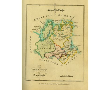
Lot 37
With Hand-Coloured MapsScale (Bernard) An Hibernian Atlas: or General Description of the Kingdom of Ireland. 4to L. 1776. First Edn., engd. title, dedit & index, hd. cold. map of Ireland & 36 full page maps of Provinces & Counties (37 maps in all), cont. hf. calf, worn (needs rebinding), mor. label. A very clean copy. (1)

![[Hyde (Dr. Douglas) An Craoibhín] A short ALs., dated 20.12.[19]39, on verso of a Brian O'Higgins Card, to An Craoibhín from](https://cdn.globalauctionplatform.com/a1235de0-ae2f-4b31-9734-a76000fab544/b798e77d-a208-4e58-b648-e14bcb9986b8/468x382.jpg)
Lot 401
[Hyde (Dr. Douglas) An Craoibhín] A short ALs., dated 20.12.[19]39, on verso of a Brian O'Higgins Card, to An Craoibhín from Múirgheal Ní Bhroin, explaining why she has not written earlier and sending him a booklet by O'Higgins, etc. The paragraphs crossed off in pencil, probably by Hyde; also a small bundle of various Notes, including an English translation of the Gaelic Lament for Pádraig Sairséal, in Hyde's hand, written on an invitation from Castlerea Lawn Tennis Club; a note about a poem of his which has been translated without attribution; a sketch map with directions; and a few other items, one of them possibly not in Hyde's hand. As a lot of m/ss, w.a.f. (1)
![P.S. O'Hegarty's Copy[Yeats (Jack B.)] Marriott (Ernest) Jack B. Yeats Being A True Impartial View of his Pictorial & Dramati](https://cdn.globalauctionplatform.com/a1235de0-ae2f-4b31-9734-a76000fab544/81a01754-4cf6-4721-c94c-82929119d839/468x382.jpg)

![[Irish Map] Ortelius (Abraham) Hibernia Eryn Hiberniae Britannicae Insula Nova descriptio - Irlandt, hd. cold. engd. map, [is](https://cdn.globalauctionplatform.com/a1235de0-ae2f-4b31-9734-a76000fab544/c77a9977-6825-4fff-bfe2-8a64bd18d942/468x382.jpg)
Lot 508
[Irish Map] Ortelius (Abraham) Hibernia Eryn Hiberniae Britannicae Insula Nova descriptio - Irlandt, hd. cold. engd. map, [issued in Ortelius Theatrum Ordis Terrarum] * dated 1572, approx. 44cms x 55cms (17" x 21 1/2") overall, contemp. hd. colouring, unframed. Clean Copy. (1)* Ireland first appeared in Ortelius Theatrum in 1573 as an additamentum.

Lot 534
Coloured Cartoon Prints: O'Nuallain (Michael) A large Cartoon Print - Flann O'Brien, Map of Ireland - Hung, Drawn & Quartered, by Michael O'Nuallain; approx. 71cms x 60cms (28" x 24") framed; together with a Cartoon Print of Brendan Behan - Dublin Millenium, approx. 40cms x 32cms (16" x 12 1/2"), framed. (2)

Lot 567
Signed Presentation CopyKavanagh (Peter) Inniskeen Circa 1939, A Map (Peter Kavanagh Hand Press, New York 1978), First Edition, tall narrow wrappers with folded map tipped in, No. 205 of 470 numbered Copies. Inscribed by Peter Kavanagh for Grattan Freyer, 'corrected N.Y. 22 Ap. 78'. Essential for Kavanagh lovers, identifying various fields, roads and homesteads relevant to the poet and his work. A very fine Copy. Very scarce. (1)

Lot 7
Extremely Rare Report - The Belfast Pogrom, 1920 - 1922Only a Handful of which were for Private DistributionNorthern Ireland: Kenna (G.B.) [Fr. John Hassan] Facts and Figures of the Belfast Pogrom 1920 - 1922, 8vo D. (O'Connell Published Co.) 1922. Sole Edn., fold. map, hf. title, title, 213pp. orig. green cloth, lettered within black border. A very fine copy of this Scarce Work.* This work was reportedly commissioned by the Free State Government, at the instigation of Michael Collins to document the notorious Belfast Pogroms in which hundred of Catholics (together with some Protestants) were driven from their homes and work places, and when hundreds were killed. The work which was set in type, but publication had to be cancelled for fear of furthering more serious sectarian tensions. It is believed only about eighteen copies were ever bound. An excessively rare item. (1)

Lot 727
Thompson (Mrs. D.P.) A Brief Account .. In Dingle and the West County of Kerry, Ireland, 8vo L. (Seeley...) 1846. First Edn., fold. map frontis, green cloth; Weld (Isaac) Illustrations of the Scenery of Killarney and the Surrounding County, 4to, L. 1802, 19 maps & plts (complete) hf. mor., worn. (2)

![[I.A.S.] O'Flaherty (R.) A Chronological Description of West or h-Iar Connaught, 4to D. (I.A.S.) 1846, map & fold. chart; O'D](https://cdn.globalauctionplatform.com/a1235de0-ae2f-4b31-9734-a76000fab544/a3d5a1ab-64d0-46c3-a1e6-b08a3c5cef27/468x382.jpg)
Lot 79
[I.A.S.] O'Flaherty (R.) A Chronological Description of West or h-Iar Connaught, 4to D. (I.A.S.) 1846, map & fold. chart; O'Donovan (J.) The Tribes and Customes of Hy-Many, 4to D. (I.A.S.), map & fold. chart; Henthorn Todd (J.) Leabhar Imuinn. the Book of Hymns of the Ancient Church of Ireland, 2 vols.4to, D. (I.A.S.) 1855 - 69; O'Donovan (J.) The Topographical Poems of John O'Dubhagain and Giolla na Naomh O'Muidhrin, 4to D. (I.A.S.) 1862; Butler (Rev. R.) Registrum Prioratius Omnium Sanctorum, 4to D. (I.A.S.) 1845, & 2 others from the same series, all blind decorated purple cloth, clean set. (8)


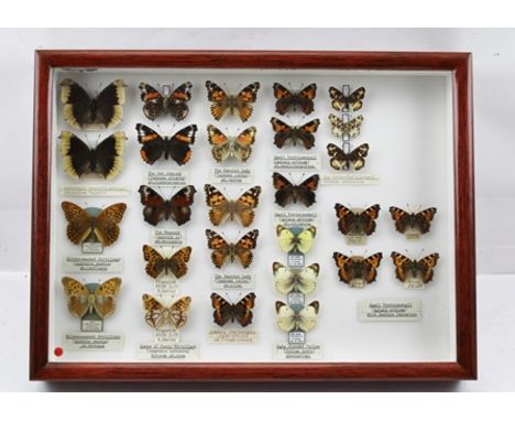
Lot 266
STRIKING COLLECTION OF "TEMPERATURE, GENETIC & WILD CAPTURE" ABERRATION OF BUTTERFLIES, to include CAMBERWELL BEAUTY (N. antiopa) abberation hygeia, bred EX.LARVAE, M. HARVEY JULY 1979 MALE AND FEMALE. SILVERWASHED FRITILLARY (A. paphia) MALE, ab.c onfluens, bred ASHELYST FOREST, DEVON 1975, R.W. CROUTHERS. SILVERWASHED FRITILLARY (A. paphia) MALE UNDERSIDE, ab.bronzus, ASHELYST FOREST, 1975 R.W. CROUTHERS. RED ADMIRAL (V.atlanta) ab.Klemensiewiczi, bred EX.PUPAE, J.H. PAYNE 1985. THE PEACOC K (I.10), ab.belisaria. Queen of Spain Fritillary (A. lathonia) Extreme ab.nova, Tingewick, BUCKS, X.09, K. BAILEY. THE PAINTED LADY (V. Cardui), ab. varina, ab.elymi. THE SMALL TORTOISESHELL (A. urticae) ab.pseudo Connexa, ab. semiichnusoides, ab. conjuncta. THE PALE-CLOUDED YELLOW (C.hyale) aberration, ex.ova PERRANPORTH, CORNWALL, 2011 (3 specimens) THE MAP BUTTERFLY (A. levana) 3 specimens, extreme aberration 'nova'. THE SMALL TORTOISESHELL (A. urticae). 4 specimens Wild Capture Variat ion. Attractively presented and labelled in glazed Watkins and Doncaster display case.


Lot 65
A Box of Miscellaneous Ephemera, including a ten shilling Deed from Osborne Markham, Master of Art, Vicar General and Official Principal of the Most Father God, William Divine Provenance, Lord Archbishop of York dated 1804, 1908 shipping lines and routes map, 1915 London Mail Magazine, 1820 vellum indenture, The Bookworm Magazines, etc.


Lot 159
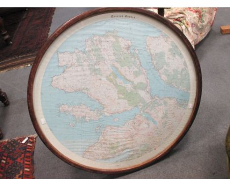
Folding maps.- Mudge (Lt. Col. William) Ordnance Map of Cornwall, engraved map on 6 sheets, folding in sections and linen-backed, 1813; and a quantity of other folding maps, almost all 19th century, including county maps by Walker, Ordnance Survey by Stanford, other Ordnance maps by Mudge (c.1809-13), Bradshaw and other railway maps, Colton's Mexico (1890), Gardner's Geological Map (1842), Wyld's Country Twenty-Five Miles round London, Reynolds's Geological Atlas, various Geological Survey maps and others of Switzerland, Italy, France and Germany, many with hand-colouring and in original slip-cases or folding into original covers, v.s. (c.100)
Lot 174
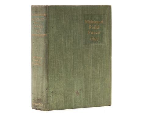
Churchill (Winston Spencer) The Story of the Malakand Field Force, first edition, first state without the errata slip preceding the map, frontispiece portrait, 6 maps (2 folding), 32pp. advertisements dater 12/97, occasional scattered spotting, original cloth, spine a little spotted and faded, light soiling to spine ends, some minor marking to covers, still a very good, sharp copy, [Woods A1(a)], 8vo, 1898.
Lot 175
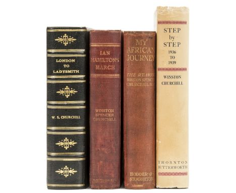
Churchill (Winston Spencer) London to Ladysmith via Pretoria, 3 folding maps, illustrations, 34pp. advertisements, some occasional spotting, ink stamp to half-title, modern black morocco, original upper cover and spine bound in, London, New York & Bombay, 1900; Ian Hamilton's March, frontispiece and folding map, 34pp. advertisements, occasional spotting, half title browned, original cloth, recased, spine darkened, light fading to covers, 1900; My African Jouney, frontispiece and plates, 3 maps with routes in red, spotting, endpapers browned, original pictorial cloth, rebacked preserving original backstrip, spine ends repaired, light rubbing and soiling, 1908, first editions, [Woods A4, A5, A12]; and a second impression Step by Step, 8vo (4)
![Milne (A.A.) [The Christopher Robin books], 4 vol., comprising When We Were Very Young, second issue with roman numerals on C](https://cdn.globalauctionplatform.com/2c1ab993-ebb4-4bfb-8862-a76100dfaa2f/df5a2971-75e2-42d9-98e7-4132563b15cd/468x382.jpg)
Lot 206
Milne (A.A.) [The Christopher Robin books], 4 vol., comprising When We Were Very Young, second issue with roman numerals on Contents page, inner gutter split but gatherings holding firm, cutting pasted to rear endpaper, ink inscription to front pastedown, light browning to endpapers, 1924; Winnie-the-Pooh, map endpapers (a little browned), original deluxe blue limp calf, gilt, spine rubbed and faded, 1926; Now We Are Six, pictorial endpapers, spine slightly darkened, dust-jacket, spine a little darkened, minor sympathetic restorations to spine ends and corners, 1927; The House at Pooh Corner, browning to pictorial endpapers, spine faded and with very small stain to upper cover, 1928, first editions, illustrations by Ernest H. Shepard, all but the second mentioned in original pictorial cloth, gilt, 8vo.
-
109198 item(s)/page