We found 109182 price guide item(s) matching your search

Refine your search

Year

Filter by Price Range
  • List
  • Grid
  • 109182 item(s)
    /page

Lot 607

Mercator/Cloppenburgh, 1630 Terra Sancta quae in Sacris, Terra Promissionis Palestina This small map is based on Ortelius` famous map of the Holy Land. It is oriented with east at the top and centered on Samaria. The Dead Sea has four cities shown burning within it: Sodoma, Gomorra, Adama and Seboim. The map is adorned with a strapwork cartouche. French text on verso. 10.1"" W x 7.5"" H Attractive color with a faint damp stain along bottom of map and a few tiny edge tears that have been professionally repaired.

Lot 609

Tavernier, Melchior 1640 Patriarchatus Hierosolymitani Geographica Descriptio This is a handsome map covering the region from the Nile Delta to Lebanon. It shows the extent of the Patriarchate of Jerusalem in Roman times. An elegantly designed title cartouche fills the Mediterranean Sea. 19.8"" W x 13.8"" H Watermarked paper with original outline color and later coloring in the cartouche. There is minor soiling and one short crack caused by the oxidation of the original green pigment that has been closed on verso with archival tape.

Lot 610

de la Rue, Philippe 1651 Regnum Salomonicum seu Tabula Digesta ad Libros Very handsome map of the Holy Land during the reign of King Solomon, showing the provinces of the Twelve Tribes. Solomon reigned over a large region that included Damascus in the north and the entire area east of the Jordan. The Mediterranean coastline is depicted from Sidon to Sirbon Lacus. Haifa Bay is enlarged and there is an imaginary bay south of Jaffa. The map is adorned with a lovely drape and ribbon-style cartouche. 21.4"" W x 15.6"" H Lovely color on watermarked paper with one minute hole under title cartouche.

Lot 611

Moxon, Joseph 1671 Israels Peregrination, or the Forty Years Travels of the Children of Israel Out of Egypt Through the Red Sea, and the Wilderness into Canaan, or the Land of Promise This map shows the Palestinian and Lebanese coast and depicts the Jews` passage through the Red Sea and the Sinai Desert. North is oriented to the right. At the bottom are vignettes displaying the encampment of the tribes flanked by Aaron and Moses as well as Temple vessels held up by putti. Originally by Nicolas Visscher, the map was translated into English by Joseph Moxon. 18"" W x 12.4"" H There is a printer`s crease at top left and light toning along sheet edge at left.

Lot 614

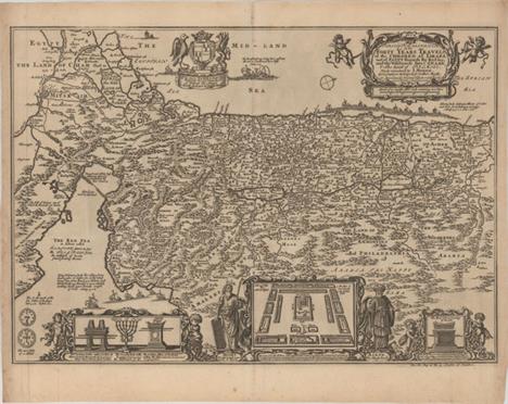
Jansson, Jan 1677 [On 6 sheets] Dimida Tribus Manasse ... [and] Tribus Ruben, et Gad ... [and] Pars Maxima Tribus Iuda ... [and] Tribuum Ephraim ... [and] Tribus Aser ... [and] Tribus Simeon Â… This superb, large wall map on six separate sheets is based on Adrichom`s ""Situs Terrae Promissionis."" Oriented to the east, the map shows the region divided into the twelve tribes on both sides of the Jordan River, the shoreline running from Sidon to Alexandria. The Cison Torrens (Kishon River) is shown as connecting the Sea of Galilee with the Mediterranean Sea, and there are many nonexistent rivers, e.g., a river connecting Jerusalem with the Dead Sea. In the Dead Sea, four burning cities are shown: Sodoma, Gomorra, Seboim, and Adama. The dramatic map is beautifully engraved to show topographical features, major roads, towns and villages and richly embellished with dozens of biblical illustrations. Inset maps in the top corners depict Abraham`s journey and the wandering of the Israelites through the desert. This map was published in Jansson`s Accuratissima Orbis Antiqui DelineatioÂ…, with text by Georg Horn. Two of the six sheets are made up of one and a half sheets joined together, resulting in the map sometimes being described as a seven-sheet map. The two left-hand sheets measure 28.1 x 16.9"", and the remaining four sheets measure 21.3 x 17.1"". If the sheets were joined the entire map would measure 70 x 34"". 28.1"" W x 16.9"" H Fine impressions with attractive color, wide margins, and a couple of insignificant spots.

Lot 616

Sanson, Nicolas 1702 Geographiae Sacrae ex Veteri, et Novo Testamento Desumptae Tabula in qua Terra Promissa, Sive Iudaea in Suas Tribus Partesq` Distincta A fine map illustrating the lands described in the Old and New Testament. The Kishon River connects the Mediterranean to the Sea of Galilee. The map provides good detail throughout and is adorned with a wreath-style title cartouche featuring a pair of sea monsters. 19.8"" W x 15.6"" H A nice impression on a bright, watermarked sheet with ample margins and couple of small, insignificant spots.

Lot 617

Homann, Johann Baptist 1707 Iudaea seu Palaestina ob Sacratissima Redemtoris Vestigia Hodie Dicta Terra Sancta Prout Olim in Duodecim Tribus Divisa Separatis ab Invicem Regnis Iuda et Israel... Homann based this map of the Holy Land on the cartography of Guillaume Sanson. It presents the region divided among the twelve tribes of Israel and covers from Sidon to Sirbonis L in the Egyptian desert. The Kishon River is shown as connecting the Mediterranean Sea with the Sea of Galilea. The dramatic title cartouche features Moses receiving the Ten Commandments and inset in the opposite corner is a map showing the Exodus and Wandering surrounded by a finely engraved scene including Moses, Aaron, and the two spies of Moses bearing a huge bunch of grapes. 22.3"" W x 19.1"" H A dark impression with original color on watermarked paper with toning along the centerfold, a spot of minor soiling, and a tiny wormhole near the centerfold.

Lot 619

Bachiene, Willem Albert 1749 Afbeelding van `t Land van Israel, Naar Deszelfs Natuurlyke GesteltheidÂ… This attractive map from a large Dutch Bible shows the land of Israel with all the places, rivers, mountains, and seas mentioned in the Holy Scriptures. It covers all of Palestine on both sides of the Jordan River and the Mediterranean coastline from Tzor (Sur) to Rhinocolura (El Arish). At bottom is a lovely pastoral scene with Moses standing on Mount Nebo overlooking the land that God forbade him to enter. Engraved by Jan van Jagen. 15.2"" W x 19.4"" H A clean, watermarked sheet with light toning along sheet edges.

Lot 620

Anon., 1750 Nouvelle Carte de la Terre Sainte pour Servir a l`Intelligence de l`Ancien, & du Nouveau Testament This is a handsome map showing the divisions of the twelve tribes in the Holy Land, with many place names and topographical details. A decorative title cartouche adorns the map featuring Moses` spies carrying the fruit from the Promised Land. 14.6"" W x 10.7"" H Issued folding, now pressed on watermarked paper with wide margins and a few printer`s creases.

Lot 621

Bachiene, Willem Albert 1750 T` Land Kanaan Benevens Gilead Verdeelt Onder de XII Stammen Israels... This attractive map from a large Dutch Bible shows the land of Israel divided into the 12 Tribes with all the places, rivers, mountains, and seas mentioned in the Holy Scriptures. It covers all of Palestine on both sides of the Jordan River and the Mediterranean coastline from Tzor (Sur) to the ""River of Egypt."" At bottom is a lovely pastoral scene with the Elders of Israel encircling a map and dividing the land among the Tribes. Engraved by Jan van Jagen. 15.3"" W x 19.5"" H Attractive color on watermarked paper with minor offsetting and a hint of toning along centerfold and sheet edges.

Lot 627

Calmet, Augustin 1727 Nieuwe Plattegrond van het Oude Jeruzalem Volgens den Schryver A simple bird`s-eye view of the ancient city of Jerusalem shows its divisions with prominent depictions of the Temple of Solomon and the royal palace and gardens. The map is oriented with west at top, with the Calvary outside the city walls at top right. 17"" W x 12.6"" H Issued folding on watermarked paper with a few archivally repaired fold separations and narrow margins.

Lot 629

Ptolemy/Mercator, 1730 Tab. VI. Asiae, Arabiam Felicem, Carmaniam ac Sinum Persicum Comprehendens... This classical map is a landmark in the mapping of the Arabia Peninsula. Ptolemy drew on the accounts of travelers and sailors and though the information was secondhand and often inaccurate it represented the most advanced account of the world`s geography at that time. In the case of Arabia, Ptolemy overestimated both the width of the southern part of Arabia and the size and shape of the Persian Gulf. Arabia Petrea and Arabia Deserte are both placed in the north and Arabia Foelix is the term applied to the whole peninsula, rather than to the southern portions of it. Ptolemy`s map, as interpreted by European cartographers such as Mercator, was hugely influential and served as a standard for European mapping of the peninsula for many years. This map is from the last edition of Ptolemy`s Geography, having been published numerous times from 1477 to 1730. 18.4"" W x 13"" H Watermarked paper with attractive color and a slightly uneven impression along the centerfold at bottom. What appears in the image to be centerfold toning is simply show-through of the backstrap.

Lot 630

Ptolemy/Fries, 1525 [Title on Verso] Tabula V Asiae This map depicts the region between the Caspian Sea and the Persian Gulf, covering most of present-day Iran. At far left are Armenia, Mesopotamia, and Babilonia Regio (the Fertile Crescent). The map is based on the 1513 map by Waldseemuller. 19.8"" W x 12.1"" H A nice impression with wide, original margins and several small worm tracks along centerfold that have been professionally repaired, only one of which is in the image with minute loss of text.

Lot 633

Duval, Pierre 1682 Perse This miniature map of Persia depicts major towns and key topographical features. The Persian Gulf is named Mer d`El-Catif, named for the city of Al-Qatif on the Arabian Peninsula that was the major trade port of the region. Pierre Duval was Nicolas Sanson`s nephew and pupil. He published a wide range of atlases and individual maps including a fine miniature world geography with many of the maps based on Sanson. 5"" W x 4"" H A nice impression on watermarked paper with wide, original margins.

Lot 635

Tallis, John 1851 Persia Finely engraved map of Persia that extends from the Persian Gulf to the Caspian Sea. Surrounded by beautifully engraved and rendered vignettes of a Bactrian camel, a Persian, Kurds and the city of Isfahan. Surrounded by a delicately engraved decorative border. 9.9"" W x 13.7"" H Original outline color on a bright, clean sheet.

Lot 636

Hondius/Bertius, 1618 Ormus Regnum This miniature map is centered on the Persian Gulf, depicting portions of Arabia and Persia. The focus of the map is the Kingdom of Ormus, which existed between the 10th and 17th centuries. Tiny towns, rivers, and mountains are depicted, along with a strapwork title cartouche incorporating the distance scale. French text on verso. 5.3"" W x 3.8"" H A fine impression with minor show-through of text on verso.

Lot 637

Munster, Sebastian 1541 Tabula Asiae III This woodblock, Ptolemaic map covers the region between the Black and Caspian Seas. The map is divided into three regions: Colchidis, Albania and Armenia. A large gate (Portae Albaniae) is shown in the mountains at the top of the map. This reflects the legend of Alexander the Great, who is said to have discovered the evil hordes of Gog and Magog in this region. Alexander, calling upon the power of God, moved the mountains together and built a mighty wall spanning the entire Caucasus range, closing off the civilized south from the forces of darkness. Noah`s Ark is shown in the Caspian Sea. Woodblock illustration with the title Tertia Asiae on verso. 13.3"" W x 10.5"" H A clean, bright example with light show-through of text on verso and three archivally repaired tears confined to bottom blank margin.

Lot 638

Dapper, Olivier 1672 Tabula Colchidis Hodie Mengrelie An interesting map of the eastern shore of the Black Sea covering the region up to the Caucasus Mountains. A large wall is shown in the mountains owing to a legend of Alexander the Great, who is said to have discovered the evil hordes of Gog and Magog in this region. Alexander, calling upon the power of God, moved the mountains together and built a mighty wall spanning the entire Caucasus range, closing off the civilized south from the forces of darkness. The large title cartouche represents the lucrative trade between Asia and Europe. Published in Beschreibung des Konigreichs Persien, Dapper`s comprehensive treatise on Asia. 13.8"" W x 11.5"" H A fine impression with attractive color and wide, original margins. There are two printer`s creases adjacent to centerfold.

Lot 639

Sanson/Mortier, 1697 Colchis, Iberia, Albania quaeq; Caucasiae Gentes, Isthmum qui Pontum Euxinum Caspiumq; Mare Interjacet, Incolunt This attractive map focuses on the region between the Black and Caspian Seas. There is great detail of the mountains, cities and villages. Colchis is the legendary kingdom in the Greek myth wherein Jason and the Argonauts stole the Golden Fleece from King Aeetes. The decorative title cartouche is draped in a sheepskin and flanked by two hunting dogs. 18.8"" W x 14.2"" H A nice impression with bold color and very wide margins. Minor toning along sheet edges.

Lot 640

Delisle/Covens & Mortier, 1730 Carte des Pays Voisins de la Mer Caspiene Dressee pour l`Usage du Roy... This is likely the most detailed and attractive eighteenth century map to focus on Georgia, Azerbaijan and Armenia. It depicts roads, forts, cities, villages, topography and is filled with notations. The map is embellished with a title cartouche featuring the French crown and coat of arms, and two beautiful compass roses. 24"" W x 18.2"" H A fine impression with original color on watermarked paper and a hint of toning along sheet edges.

Lot 641

Ptolemy/Mercator, 1730 Tab. VII Asiae, Exhibens Scythiam, intra Imaum Sogdianam, Bactrianam, Hircaniam, aliasq. Asiae RegionesÂ… This fine copper engraved map covers Central Asia east of the Caspian Sea and what is now Turkestan, the Steppes, Afghanistan and beyond. The Himalayas and Northern India run across the bottom of the map. Mercator originally published this map in his 1578 edition of Ptolemy`s great Geography. Although he is most renowned today for the projection he popularized and for first using the term Atlas for a collection of maps, he devoted much of his life to his Ptolemaic maps. The maps were beautifully engraved as nearly as possible to their original form and embellished with fine cartouches and cultural scenes. This map includes scenes of shepherds and their flocks and a great sea monster. 17.9"" W x 13.3"" H Nice impression and color on watermarked paper. What appears in the image to be centerfold toning is simply show-through of the backstrap.

Lot 642

Mercator, Gerard (the younger) 1613 Asia ex Magna Orbis Terre Descriptione Gerardi Mercatoris Desumpta, Studio et Industria Derived from the elder MercatorÂ’s world map of 1569, this map of Asia was engraved by his grandson. The coasts of Northeast Asia and Northwest North America are separated by Gastaldi`s fabled Strait of Anian. South of this strait a beautifully engraved galleon gives speculation to the possibility of a northern route to Asia. Sumatra has a curiously archaic outline, while the relationship between New Guinea and Terra Australis is left to the viewer`s imagination. The place names, Beach, Regio, Lucach and Maletur are all taken from Marco Polo`s account, but erroneously ascribed to locations in the vicinity of present-day Australia. French text on verso. 18.4"" W x 14.8"" H In striking original color on watermarked paper with an extraneous crease parallel to the centerfold that runs the length of the sheet, an edge tear at top that just enters the neatline and has been closed with archival tape, and faint foxing that is most

Lot 643

Blaeu, Willem 1642 Asia Noviter Delineata This is one of the most famous 17th century maps of the continent of Asia. It is surrounded in a beautiful carte-a-figures border and is richly ornamented with animals, sea monsters and sailing ships. The eastern coastline of Asia is severely truncated, Korea is shown as an island, and Japan is depicted on the Ortelius-Teixeira model. The Indian subcontinent is too narrow and the islands of Indonesia are very sketchy. A large island labeled Ceiram probably represents the western part of New Guinea. In the interior, the Caspian Sea is oriented on an east-west axis and there are several large erroneous lakes in China including the mythical Chiamay Lacus. The frieze across the top features vignettes of the cities of Candy, Calecut, Goa, Damascus, Jerusalem, Hormuz, Banten, Aden and Macao. The inclusion of Banten reflects the emergence of the Dutch as a major commercial power in the East Indies. The side panels flanking the map depict costumed figures of the various Asian peoples. This is a later edition with evidence of a crack in the copperplate at bottom center. Dutch text on verso. 21.9"" W x 16.2"" H A lovely old-colored example on watermarked paper with a spot in the Pacific and a hint of toning.

Lot 644

Delisle/Covens & Mortier, 1730 L`Asie Divisee en Ses Principales Regions, et ou se Peuvent Voir l`Estendue des Empires, Monarchies, Royaumes, et Estats... An attractive map of Asia based on the Sanson-Jaillot map of 1692, with the now obsolete delineation of Siberia and Japan. The island of Hokkaido is attached to the mainland as part of the Yupi peninsula. Korea appears as an elongated peninsula, and the mythical Lac de Chiamay is shown as the source of five major rivers in Cochinchine. Covens & Mortier updated the map to include the northern coastline of Australia (Nouvelle Hollande) based on the Delisle configuration of 1705. The upper corners contain a decorative title cartouche with a dedication to the Duc de Bourgogne and a scale of miles cartouche. The title appears in Latin above the map: ""Asia Divisa in Imperia Regna & StatusÂ…"" 22.9"" W x 18.4"" H A fine impression with original color and a hint of toning along sheet edges.

Lot 645

Aa, Pieter van der 1730 L`Asie, Suivant les Nouvelles Observations... Attractive map of the continent and the East Indies. The most interesting region of the map is the depiction of Japan and the Northeast coast of the continent. Japan is connected to a huge land mass to the north, which is named Terre d` Yeco, a Jesuit name for Hokkaido. To the west is Terre de la Compagnie (noted as being discovered by the Portuguese explorer Vasco da Gama). Witsen`s icy cape is prominently shown to block travel into the Arctic regions. The pictorial cartouche features a royal procession. 11.7"" W x 8.9"" H Issued folding with attractive color and a small spot of soot at top right.

Lot 646

Danet, Guillaume 1732 L`Asie Dressee sur de Nouveaux Memoires Assujetis aux Observations Astronomiq... ""This is one of the most distinctive and decorative maps of Asia from the 18th century. It is surrounded by an intricately engraved border composed of the coats of arms of Asian nations and is embellished with a large allegorical title cartouche. This map was drawn and engraved by J. Luillier and published by Guillaume Danet, son-in-law of Nicholas de Fer. Danet was not a prolific publisher and his separately issued maps are quite scarce. While much of the map is based on Delisle`s revised map of Asia [1722], this map presents an early depiction of Kamchatka taken from Strahlenberg`s map [1730], which was in turn was based on the work of Abu Al-Ghazi Bahadur`s history of the Tartars. There are a number of notations in the region noting that the inhabitants either pay tribute to, or are the enemies of, the Moscovites. Korea is depicted as a blunt peninsula and the sea between it and Japan is called the Detroit de Coree."" 28.1"" W x 19.4"" H On watermarked paper with minor soiling, some printer`s ink residue, and a professionally repaired cut measuring 6.5"" at bottom right.

Lot 647

Laurie & Whittle, 1794 [On 2 Sheets] Asia and Its Islands According to d`Anville: Divided into Empires, Kingdoms, States, Regions, with The European Possessions and Settlements in the East IndiesÂ… A superb, large-scale map based on the cartography of the famous French cartographer Jean Baptiste Bourguignon d` Anville. It provides an extremely detailed view of the continent and extends to include all of South East Asia and numerous islands of the Pacific, with emphasis on English exploration. The discoveries of Capt. Cook appear in the Aleutian Islands (Foxes Islands) and the Northeast coast of Asia. Hokkaido is featured as an archipelago named Isles of Yeso, including the Three Sisters. The Carolines are accurately depicted on an east-west axis. The large decorative cartouche features an Asian merchant, his exotic goods, and a camel. If joined together, the map would measure 46.8 x 40.4"". 46.8"" W x 20.2"" H Issued on watermarked paper with moderate offsetting, brown stains, a 6-7"" clean fold separation on each sheet, and two small holes along the top border.

Lot 648

Tallis, John 1851 Asia Finely engraved map of Asia that extends from Turkey through China and Russia to show a little of Alaska, and from the Arctic Ocean south to delineate all of the East Indies. Beautifully engraved and rendered vignettes of Petra, Tartars, Russian Peasants, The Walrus, and Sun-Birds of India and the Philippine Isles. The map is surrounded by a decorative border. 12.7"" W x 10.2"" H Original outline color. There are binding holes and a few small abrasions all confined to the top blank margin.

Lot 650

Merian, Matthaus 1646 Tartaria Sive Magni Chami Imperiorum A deftly engraved map based on Blaeu`s map of Tartaria and northern China with information that was compiled by the English and Dutch explorers as well as the reports of Marco Polo and the Greek classics. Tiny devils and dragons frolic in the desert outside the Great Wall and numerous notes fill the unexplored regions. The decorative features of the map are also similar to Blaeu`s; the title is symbolically engraved onto the saddle blanket of a camel, representing the trade over the Silk Road. 13.8"" W x 10.6"" H Heavy, watermarked paper with attractive color, a hint of toning along centerfold, and an abrasion in left blank margin.

Lot 652

Cluver, Philipp 1697 Scythia et Tartaria Asiatica This attractive map of northern and central Asia shows ancient divisions and place names. The northeastern coastline is severely truncated. Adorned with a decorative title cartouche featuring a lion. 10.1"" W x 8.3"" H A dark impression with a hint of toning along centerfold.

Lot 653

Aa, Pieter van der 1714 La Grande Tartarie Suivant les Nouvelles Observations de Messrs. de l`Academie Royale des Sciences, etc. ""This is a great small map of the northern parts of Asia extending from the Black Sea through northern China and Korea. The map is filled with an amazing amount of detail for its size. Terre de Jelmer, """"discovered in 1664 par Corn Jelmerse Kok,"""" forms a bridge between Novaya Zemlya and the mainland east of the Yenisey estuary. Witsen`s Icy Cape protrudes in the Arctic Ocean. The pictorial title cartouche features a Cossak encampment."" 11.8"" W x 8.9"" H A fine impression on watermarked paper with wide margins and a bit of printer`s ink residue.

Lot 657

Bellin, Jacques Nicolas 1750 Suite de la Carte de la Siberie et le Pays de Kamtschatka pour l`Histoire Generale des Voyages A fine map of eastern Siberia above and below the Arctic Circle, showing the Sea of Okhotsk, the Kamtschatka Peninsula, and Sakhalin Island. The map depicts Russia`s northern coastline along the Arctic Sea, and shows the tracks of an exploratory voyage to Kamtschatka made in 1648 by three Russian ships. The land is filled with rivers and mountain ranges, with a few cities, towns, and regions identified. A decorative title cartouche in top right containing leaf, flower, and scroll motifs adorns the map. 10.3"" W x 9.5"" H A nice impression with some light toning in the blank margins.

Lot 658

Bonne, Rigobert 1780 Plan de la Baye d`Awatska... [on sheet with] Plan du Typa ou de Macao [and] Partie du Japon ou Nipon Copper engraving with detailed maps of Kamchatka, part of Japan, and the island of Macao. The Kamchatka map includes an inset: Plan du Havre de St. Pierre et St. Paul. Soundings, anchorages, and topographical details are shown. Engraved by Andre. 9.3"" W x 13.6"" H On watermarked paper with a few small spots and minor offsetting.

Lot 659

U.S. War Department, 1904 Map of Korea and Manchuria Prepared by the Second Division, General Staff (Military Information Division)... This large, highly detailed map covers the scene of the conflict during the Russo-Japanese war, which was considered the first major war of the 20th century. It is filled with hundreds of place names, roads and communication cables on both land and sea. Includes insets of Port Arthur and Vladivostok with an index map at bottom. Prepared by the War Department and published as a supplement to the March 1904 issue of the National Geographic Magazine, shortly after the conflict broke out. 33.8"" W x 39.3"" H Issued folding with a narrow right margin, several small splits at fold intersections, and some occasional light toning.

Lot 660

Blaeu, Johannes 1655 Suchuen, Imperii Sinarum Provincia Sexta The second landmark in the European mapping of China was the appearance of the Novus Atlas Sinensis in 1655. It was compiled by Father Martino Martini, an Italian Jesuit and produced by the most prominent Dutch cartographer of the time, Johannes Blaeu. Father Martini compiled the work based on Chinese sources between 1643 and 1650, and it greatly advanced European knowledge of the region including the astronomical positions of many cities and topographical features. It remained the standard geographical work on that country until the publication in 1737 of D`Anville`s Atlas de la Chine. This map of the Suchen province is decorated with two particularly graphic cartouches. The scales are flanked by mythical woodwose who represent the mighty Yangtze River, and a warlord and his guard stand behind the title cartouche. 19"" W x 15.7"" H Dark impression and wide margins with a few tiny centerfold separations and some light, uneven toning.

Lot 662

Jansson, Jan 1656 Imperii Sinarum Nova Descriptio. Auctore Joh van Loon This superb map of the Chinese Empire is drawn largely from the Blaeu map compiled by Jesuit Father Martino Martini who traveled through the region between 1643 and 1650. It deviates from that model in its depiction of the Korean peninsula, which is shown with a cluster of islands at its southern tip. The map is embellished with sailing ships and Chinese junks. The title cartouche is flanked by Chinese and Jesuit men and the scale of miles cartouche is surrounded by putti. Engraved by Johannes van Loon. 21"" W x 18.6"" H Marginal soiling.

Lot 663

Bellin, Jacques Nicolas 1748 L`Empire de la Chine pour Servir a l`Histoire Generale des Voyages Attractive and detailed map of China and Korea, with Canton, Nanking, and Taiwan noted. Taiwan is called Isle Tay-wan ou de Formose, and the Sea of Japan is labeled Mer de Coree. A note at bottom left explains that towns of the ""First Order"" are indicated on the map with Roman lettering, while towns of the ""Second Order"" are indicated by italics. The map is adorned with a large decorative title cartouche featuring flowers and wind heads with dragonfly wings. 15.9"" W x 11.4"" H Issued folding, now pressed flat, on watermarked paper with a damp stain at bottom that just enters the neatline, very faint offsetting, and several small edge tears confined to the blank margins.

Lot 664

Brue, Adrien Hubert 1821 Carte Generale de l`Empire Chinois et du Japon Beautifully engraved and highly detailed map that shows the size and breadth of China to include Taiwan (Formosa) and extends to include Korea and all of Japan. Filled with watershed and topographical detail, the map also locates the Great Wall and scores of towns. Names the Straits of Korea, but calls the sea between the two countries the Sea of Japan. Brue`s embossed stamp with fancy lettering and flourishes embellishes the title. A decorative keyboard-style border surrounds the map. 20.3"" W x 14.4"" H This example has wide margins and original outline color with some light offsetting and toning.

Lot 666

Homann Heirs, 1750 Et des Rojaumes de Coree et de Iapan This is the eastern half of a two-sheet map of northern Asia, depicting northeastern China, Korea and Japan. There is great detail throughout of towns, political divisions, rivers and topography. There is particularly good detail throughout Korea, based on Jesuit missionary surveys. Two islands appear between Honshu and Sakhalin, following the mistaken discoveries of Maerten Gerritsz Vries in 1643. 15.6"" W x 19.8"" H A nice impression with original color and light soiling. There are two tears and a centerfold separation that enter 1-2"" into map at bottom that have all been closed on verso.

Lot 669

Marmocchi, Francesco 1845 Impero del Giappone This map depicts Japan divided into provinces with a few place names. The map extends to include part of Korea. A rare Italian map. 9.4"" W x 7.7"" H A bright example with a few minor spots.

Lot 670

Tallis, John 1851 Japan & Corea Handsome and detailed map of the region embellished with three vignettes: a ceremonial barge, Korean dress, and a view of Yedo (Tokyo). The coastline of Korea is considerably less precise than that of Japan, as it was still relatively unknown. Surrounded by geometrically designed borders accented by flowers in the corners. 13.2"" W x 10"" H Original outline color with minor even-age toning.

Lot 671

Duval, Pierre 1682 Isles du Iapon This little map is important in the cartographic history of Japan because it presents a new form in the evolution of the European mapping of Japan. Duval altered the Blancus/Moreira type by changing Lake Biwa into a wide gulf, while Kyushu appears as a very rugged narrow island and Honshu takes on an exaggerated mushroom shape. This cartography was copied by several other cartographers, particularly in pocket atlases. This is a later state of the map with Korea acknowledged as being a peninsula. Pierre Duval was Nicolas Sanson`s nephew and pupil. He published a wide range of atlases and individual maps including a fine miniature world geography with many of the maps based on Sanson. 4.9"" W x 3.9"" H A nice impression on watermarked paper with attractive old color that has been partially refreshed and light toning along centerfold and sheet edges.

Lot 672

Bellin/Van Schley, 1752 Carte de l`Empire du Japon This is a reduced Dutch version of Bellin`s influential map made for Jesuit Father Pierre-Francois-Xavier de Charlevoix`s Histoire du Japon, published in 1758. Japan is presented on the Kaempfer/Scheuchzer model with several corrections to the coastlines, and individual provinces are delineated via engraved line. The Mer de Coree is shown to the west. The decorative rococo-style title cartouche includes two distance scales. Dutch title below the map image. Engraved by J. van Schley. 12.3"" W x 8.4"" H A crisp impression, issued folding and now pressed flat.

Lot 673

Zatta, Antonio 1785 L`Impero del Giapon Diviso in Sette Principali PartiÂ… This detailed map of Japan is divided into seven principal provinces and depicts numerous towns, mountains, and rivers. The map represents typical European cartography of the late 18th century, with a misshapen Honshu and an elongated Lago d`Otis (Lake Biwa). The map is adorned with a decorative title cartouche with potted plants and a parasol. Engraved by G. Pitteri. 15.5"" W x 12"" H Original color on watermarked paper with light toning and scattered foxing.

Lot 674

Bellin/Van Schley, 1752 Plan de Jedo This detailed plan of Tokyo is patterned on the Scheuchzer/Kaempfer map of 1702. The grounds surrounding the Edo Palace depict an imaginary, French-style, formal garden. The Niponbas, ou le Pont du Japan, marked with a B, is shown east of the palace, and the Shinagawa ward of the city is indicated by a C. This version of the plan has a decorative rococo-style title cartouche. Titled in Dutch below the map: Platte Grond van Jedo. 9.8"" W x 9.8"" H Issued folding, now pressed flat, with remnants of hinge tape on verso. The top margin has been extended with old paper to accommodate framing.

Lot 676

Anon., 1847 [Japanese Pocket Map - Osaka, Japan] This late Edo period map depicts the city of Osaka on the southern part of Japan`s main island of Honshu. The map clearly displays streets, extensive waterways, city blocks and individual buildings including Osaka Castle. There is an unusual 5 x 8"" extension at right which shows the mouth of the Yodo River as it enters Osaka Bay (with the extension, the dimensions would measure 25.3 x 15.0""). North is oriented to the bottom. 20.3"" W x 15"" H Issued folding with a number of worm tracks and a short split at a fold intersection resulting in some small loss of image.

Lot 677

Anon., 1889-1901 [Lot of 3 - Untitled Views of Nikko, Japan] ""This lot consists of three vivid woodcut views of Nikko, Japan, a mountain resort city in the Tochigi Prefecture of Japan which is approximately 90 miles north of Tokyo. The city itself grew around the temples of Rinno-ji and Chuzen-ji, which were established in the 8th century and are prominently shown at the center of each view. The first two were printed circa 1889 and come with their original decorative woodcut envelopes. The third view, circa 1901, is focused on the center of the city near the temples and is surrounded by 12 local scenes. These maps were most likely intended for tourists, as the Japanese National Railways began service to the city in 1890. A very unusual and attractive set of views. A. [Untitled - with Envelope] (21.2 x 14.7""""). B. [Untitled - with Envelope] (21.2 x 15.0""""). C. [Untitled] (18.5 x 12.5"""")."" "" W x "" H Maps are clean and bright with brilliant color. There are several binding holes in the top margin of the third map, away from the image. Envelopes have minor soil and one of them has a small hole away from the image.

Lot 678

Ptolemy/Fries, 1535 [Title on Verso] Tabula XI Asiae This is a slightly reduced version of Waldseemuller`s Ptolemaic map drawn on the typical conical projection set in a trapezoidal frame. It illustrates the Ptolemaic concept of Malaya and Indochina, labeled India Extra Gangem or India beyond the Ganges. The map shows an oddly shaped Malaysian peninsula, labeled Aurea Chersone (Golden Peninsula) to the east of the Ganges. The Golden Peninsula was thought to be the location of Ophir, the mysterious source of SolomonÂ’s gold. The China Sea (Sinus Magnus), with yet another completely spurious landmass, is to the east of that. The map hints at the Ptolemaic concept of a landlocked Indian Ocean, in which there are several large islands. Latin text on verso, surrounded by elaborate woodcut decorations. 16.1"" W x 11.3"" H A nice impression with wide, original margins, very minor soiling, and expert paper repairs along centerfold. Light show-through of text on verso.

Lot 679

Hondius/Bertius, 1618 Malacca This handsome miniature map presents the southeast Asian mainland, based on elements from various geographic models of the time, including Plancius. The Malay Peninsula is quite malformed with a huge bay filled with tiny islands, a misinterpretation of the Mergui Archipelago, located off the western coast of Burma. Sian (Siam) is in the form of a large island at the mouth of the Chao Phraya River (Menam fluvius). Langoma (Chiang Mai) is depicted along the MeKong River, which is depicted flowing to the northwest. A strait bisects the southern tip of the Malay Peninsula, resulting from a misunderstanding of reports of a trans-peninsular river. French text on verso. 5.3"" W x 3.7"" H A fine impression on watermarked paper with minor show-through of text on verso.

Lot 681

Ptolemy/Mercator, 1730 Tab. XI. Asiae, Comprehendens Indiam Extra Gangem... This great map illustrates the Ptolemaic concept of Malaya and Indochina, labeled India Extra Gangem or India beyond the Ganges. The map shows an oddly shaped Malaysian peninsula to the east of the Ganges, and the China Sea (Sinus Magnus), with a landmass to the east of that. The map hints at the Ptolemaic concept of a landlocked Indian Ocean, in which there are several large islands. Mercator originally published this map in his 1578 edition of Ptolemy`s great Geography. Although he is most renowned today for the projection he popularized and for first using the term `atlas` for a collection of maps, he devoted much of his life to his Ptolemaic maps. The maps were beautifully engraved as nearly as possible to their original form. The map is embellished with a galleon and two native boats, elephants, camels and a caravan vignette. 12.6"" W x 13.4"" H Nice impression and color on watermarked paper with a printer`s crease adjacent to centerfold. What appears in the image to be centerfold toning is simply show-through of the backstrap.

Lot 682

Bellin/Van Schley, 1773 Carte des Costes de Cochin Chine, Tunquin, et Partie de Celles de la Chine Finely engraved map of the Gulf of Tonkin covering the coastline from Canton through to the Mekong River delta. Detail is confined to coastal place names and islands. The map is decorated with a delicate title cartouche and fleur-de-lis. An alternate Dutch title runs below the map. 5.6"" W x 8.1"" H On watermarked paper with original color and minor toning along sheet edges.

Lot 683

Hondius/Bertius, 1618 Philippinae Insulae Charming miniature map of the Philippine archipelago, extending south into Borneo, with north oriented to the left. This was one of the first two maps published that focused on the Philippines and used the term Philippines within the title. Based on Plancius` map of 1590, the map depicts Luzon with a truncated southeast peninsula. Samar is shown fairly accurately, here labeled Achan and Tandola, however the islands between Mindanao and Luzon are still depicted in a rudimentary fashion. Palawan is mistakenly labeled Calamianes, which is actually a smaller group of islands between Mindoro and Palawan. The map is embellished with two strapwork cartouches and a moire-patterned sea. French text on verso. 5.4"" W x 3.8"" H A fine impression on watermarked paper with minor show-through of text on verso.

Lot 684

Bellin, Jacques Nicolas 1752 Carte des Isles Philippines Dressee sur la Carte Espagnole du R.P. Murillo de Velarde 2e Feuille... Attractive map depicts the southern islands of the Philippine archipelago, including Mindanao, Palawan, Panay, and part of Borneo. The map has good detail throughout and is adorned by a lovely rococo-style title cartouche. 11.9"" W x 8.3"" H Minor toning in the blank margins and a few faint spots.

Lot 686

Munster/Petri, 1588 Sumatra ein Grosse Insel so von den Alten Geographen Taprobana Genennet Worden Early, desirable map of the island of Sumatra and the southern part of Malaysia. This map is Petri`s revision of the early Ptolemaic map of the same name, which confused Sumatra with the island of Ceylon. It is one of the earliest maps to focus on this region. Shown near today`s Singapore on the tip of the Malay peninsula is Cingafufa. Text to the right quotes Pliny, and below is a large engraving of an elephant and his mounted handler (oddly dressed in European clothes). German title and woodcut illustration on verso. 14.2"" W x 12.4"" H A nice impression with moderate toning, a small separation along centerfold that has been closed on verso with archival tape, and several stains.

Lot 687

Hondius/Bertius, 1618 Sumatra Insula This handsome map of Sumatra is oriented with north to the right, and extends to show portions of Java and the Malay Peninsula. The equator is prominently shown through the middle of the map, and a large ship and two decorative cartouches complete the composition. French text on verso. 5.3"" W x 3.7"" H A fine impression with minor show-through of text on verso.

Lot 689

Apres de Mannevillette, Jean B. N. D. 1775 Carte de la Cote Occidentale de l`Isle Sumatra, Depuis la Pointe d`Indrapour Jusques au Detroit de la Sonde This sea chart depicts the southern portion of the western coastline of Sumatra, from just north of Mukomuko to Lampung Bay and the Sunda Strait. The islands of Enggano (Isla Trompeuse) and Krakatoa (I. Du Prince), as well as the western tip of Java are noted. Numerous soundings, rocks, shoals and safe anchorages are shown. 19.1"" W x 25.6"" H A fine impression on watermarked paper with a faint damp stain along centerfold at right and a few tiny spots. There are a few shadows caused by our scanner that appear in the image, but are not on the map itself.

Lot 690

Hondius/Bertius, 1618 Borneo Insula A miniature map of Borneo largely based on the map of Theodore de Bry. The map is oriented with north to the right with the hypothetical eastern coastline and place names primarily derived from Portuguese records. The interior is filled with mountains, forests, and a large river. French text on verso. 5.3"" W x 3.7"" H A fine impression with minor show-through of text on verso.

Lot 692

Duval, Pierre 1682 Isles de la Sonde This miniature map covers Malaysia, Borneo, Java and Sumatra and depicts major towns and islands. Sincapura (Singapore) is prominently named at the tip of Malaysia. Pierre Duval was Nicolas Sanson`s nephew and pupil. He published a wide range of atlases and individual maps including a fine miniature world geography with many of the maps based on Sanson. 4.9"" W x 3.9"" H A nice impression with attractive color on watermarked paper and light toning along the centerfold.

Lot 693

Delisle/Covens & Mortier, 1730 Carte des Cotes de Malabar et de Coromandel Presentee au Roy A striking map of southern India showing the Malabar Coast, the Gulf of Cambay and the mouth of the Ganges. It extends to the Lakshadweep Islands, a portion of the Maldives and the northern tip of Sri Lanka. Cities, trade routes and topography are detailed with notes on the Dutch and English colonies along the coast. A pair of deftly engraved compass roses and a decorative cartouche complete the composition. 22.2"" W x 17.3"" H A fine impression with original color on watermarked paper and a hint of offsetting. There are some shadows that appear in the image that are caused by our scanner, and do not appear on the map itself.

Lot 694

Tallis, John 1851 Overland Route to India Two maps showing routes from Europe to India over land and by sea. The top map of Europe includes vignettes of the Post Office in London, Gibraltar, Malta and the Mail Crossing the Desert by way of camel caravan. Arabia and India are shown at the bottom with vignettes of Suez, Aden, Bombay and Madras. An ornate outline border surrounds the two maps. Maps drawn and engraved by John Rapkin, with vignettes drawn by H. Warren and engraved by J.H. Kernot. 9.8"" W x 13"" H Original outline color with minor soiling in blank margins. Binding holes in left blank margin.

Loading...Loading...
  • 109182 item(s)
    /page

Recently Viewed Lots