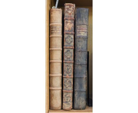
Patin (Charles). Imperatorum Romanorum Numismata ex aere mediae et minimae formae: descripta & enarrata, Paris: Apud Viduam Cramoisy Bibliopolam, 1696, [xxviii], 434 pp., including unnumbered index leaf at end, engraved portrait of the author, additional engraved title, title printed in red and black with large engraved device, 2 double-page engraved maps (Southern Europe and the Middle East), 6 full-page engraved plates, numerous engraved illustrations to text, printed bookplates of the London Numismatic Club and Patricia Milne-Henderson to front pastedown, contemporary panelled ful calf, 20th century antique-style calf reback, retaining original gilt title label, folio, together with Occo (Adolf). Imperatorum Romanorum Numismata a Pompeo Magno ad Heraclium ab Adolfo Occone olim congesta; nunc Augustorum Iconibus, perpetuis Historico-Chronologicis notis, pluribusque additamentis illustrata, & aucta...studio, et cura Francisci Mediobarbi Biragi, Milan: Ex Typographia Ludovici Montaie, 1683, lacking engraved allegorical frontispiece, title printed in red & black with engraved vignette, numerous small engraved illustrations to text, 18th century engraved bookplate of Sir Ashton Lever to front pastedown, contemporary mottled full calf, rebacked and corner repairs, retaining original gilt title label to spine, folio, plus Foy-Vaillant (Joseph). Numismata Aerea Imperatorum, Augustarum, et Cæsarum, in coloniis, municipiis, et urbibus jure latio donatis, ex omni modulo percussa, 2 parts bound in one, [2nd edition], Paris: Daniel Horthemels, 1695, titles printed in red and black with engraved vignette to each, numerous engraved illustrations to text, single folding engraved map by Auguste Lubin, bookplate of Patricia Milne-Henderson to front pastedown, contemporary mottled full calf, gilt spine, heavily rubbed and some wear, with joints cracked, folioQTY: (3)NOTE:Dekesel F-60 (Foy-Vaillant).Provenance: (Occo only) Sir Ashton Lever (1729-1788); (all three titles) Patricia Milne-Henderson (1935-2018), art historian.Ashton Lever of Alkrington (1729-1788) was only 13 when he inherited the estate of his father Sir Darcy Lever in 1742. After graduating from Corpus Christi College, Oxford he devoted himself to forming a collection of live birds, accumulating an remarkable aviary of around four thousand birds. He subsequently amassed one of the largest natural history collections of the later eighteenth century, which was eventually put on public display at his private museum, the Holosphusikon, in Leicester Square, London in 1775. A distinguished collection by any standards, the approximately 27,000 objects included a number of natural specimens not to be found elsewhere in Britain, a substantial amount of ethnographic material from Captain Cook’s second and third voyages, as well as British and foreign antiquities.

![Flint & Denbigh. Speed (John), Denbighshire [and] Flint-Shire, both published by John Sudbury & George Humble, circa](https://cdn.globalauctionplatform.com/e9dc0ac2-559f-4025-a874-ae7e01100a9c/301cefd6-540e-4a5b-b6e3-ae7f00f6d3ed/468x382.jpg)

![Ireland. Speed (John), The Province of Mounster, 1st edition, John Sudbury & George Humble [1611], uncoloured engraved ma](https://cdn.globalauctionplatform.com/e9dc0ac2-559f-4025-a874-ae7e01100a9c/f07fb0da-37e3-4c63-9868-ae7f00f6d706/468x382.jpg)


![Merian (Matthaus the younger). Abbildung der Statt und Rivier von Rochester, Chetham etc. [on sheet with] Prospect detz Enlan](https://cdn.globalauctionplatform.com/e9dc0ac2-559f-4025-a874-ae7e01100a9c/725c3433-bc90-419c-97ce-ae7f00f6e0a9/468x382.jpg)


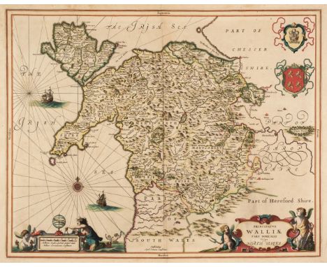


![Wales. Ortelius (Abraham & Lhuyd Humphrey), Cambriae Typus Auctore Humfredo Lhuydo Denbigiense Cambrobritano, [1598], han](https://cdn.globalauctionplatform.com/e9dc0ac2-559f-4025-a874-ae7e01100a9c/07775707-fccd-4005-8902-ae7f00f6f234/468x382.jpg)


![Worcestershire. Speed (John), Worcestershire Described, John Sudbury & George Humble [1616], hand-coloured engraved map,](https://cdn.globalauctionplatform.com/e9dc0ac2-559f-4025-a874-ae7e01100a9c/ce7a25b5-ea63-4071-b5de-ae7f00f6f85b/468x382.jpg)