We found 109182 price guide item(s) matching your search
There are 109182 lots that match your search criteria. Subscribe now to get instant access to the full price guide service.
Click here to subscribe- List
- Grid
-
109182 item(s)/page
![Ireland. Speed (John), The Province of Mounster, Thomas Bassett & Richard Chiswell [1676], uncoloured engraved map, inset](https://cdn.globalauctionplatform.com/f2d55b0d-bea0-4ba1-96c5-af5f00b8a264/f4c89541-4565-4e2a-87c2-af5f011dd888/468x382.jpg)

![Ireland. Speed (John), The Province of Ulster, Thomas Bassett & Richard Chiswell [1676], uncoloured engraved map, inset v](https://cdn.globalauctionplatform.com/f2d55b0d-bea0-4ba1-96c5-af5f00b8a264/1f63ebac-068d-412a-aa0a-af5f011dd948/468x382.jpg)
Lot 158
Le Sage (Emmanuel, Comte de Las Cases). Historical, Genealogical, Chronological and Geographical Atlas, exhibiting all the Royal Families in Europe..., translated from the last and much improved French Edition, to which have been added, six maps, composed by Madame Coindé and never before published, making it a Complete Universal Atlas..., 1813, 17 double-page engraved maps with contemporary wash colouring and 21 double-page chronological historical charts, bookplate of Ferdinand M. McVeagh, contemporary half morocco with printed title to the upper siding, upper board detached, heavily worn and frayed, folio, together with Wells (Edward). [Oikoumenes Periegesis], sive Dionysii Geographia, 4th ed., 1726, title page in Greek & Latin, sixteen engraved maps with sparse outline colouring, including two hemispheral world maps and a map of the Americas showing California as an island, later endpapers, modern calf with gilt decorated spine, 8vo, with, Hammerton (J. C. Editor). The Harmsworth Universal Atlas and Gazetteer, circa 1920, frontispiece of the flags of the British Empire, numerous colour lithographic maps, index bound at rear, contemporary half morocco, boards detached, lacking spine, folio, plus, Johnston (W. & A. K. editor). The Cosmographic Atlas of Political, Historical, Classical, Physical and Scriptural Geography and Astronomy, Edinburgh, 1884, printed title, text block detached, shaken and loose, 40 lithographic maps, some maps detached, publisher's cloth, lacking spine, boards detached, worn and frayed, folioQTY: (4)NOTE:Sold as a collection of maps, not subject to return.

Lot 159
* Lincolnshire. Blaeu (Johannes), Lincolnia Comitatus Anglis Lincoln-Shire, Amsterdam, circa 1645, engraved map with contemporary outline colouring, slight toning, one small repaired closed tear to the central fold, 420 x 500 mm, mounted, framed and glazed, together with Van den Keere (Pieter), Darbyshire, circa 1627, hand-coloured engraved map, 85 x 120 mm, mounted, framed and double-glazed, English text on verso, with Moll (Herman). The Islands of Bermudos Divided into its Tribes with the Castles Forts &c. [on sheet with] Part of Providence Island, circa 1724, two engraved maps on one sheet (as published) both with contemporary outline colouring, some offsetting, 205 x 275 mm, mounted, framed and glazed, plus Darton (William). West Indies circa 1810, engraved map with contemporary outline colouring, 185 x 315 mm, mounted, framed and glazedQTY: (4)

Lot 16
Cook (James). The Three Voyages of Captain James Cook Round the World, 7 volumes, London: Longman, Hurst, Rees, Orme, and Brown, 1821, lacking half-titles, 24 aquatint plates (out of 25), folding map in facsimile, 1 folding table (of 2), lightly toned and spotted, contemporary calf gilt, some wear, 8voQTY: (7)

Lot 161
London. Cassell, Petter & Galpin (publishers), Civitas Londinum Ano. Dni. circiter MDLX, London in the Reign of Queen Elizabeth, a facsimile (reduced) of the map by Aggas 1560, published in Cassell's Old and New London [1878], uncoloured lithographic panoramic plan on two sheets, not conjoined, old folds, some spotting, slight wear where old folds cross, each sheet approximately 455 x 615 mmQTY: (2)
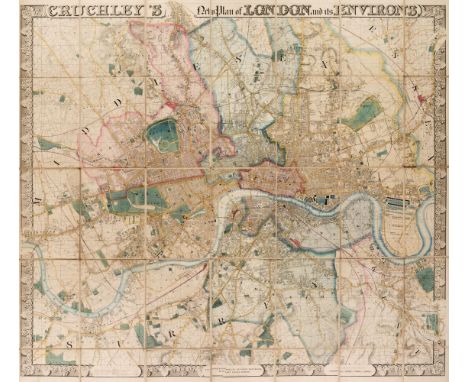
Lot 162
London. Cruchley (George Frederick). Cruchley's New Plan of London and its Environs, Engraved and Published by Cruchley, Map - Seller No. 81 Fleet Street, London (from 38 Ludgate Street). (A New Edition Improved to January 1st. 1847), large engraved map with contemporary outline colouring, sectionalised and laid on linen, decorative strapwork margins with the title above the map and a scale of references, publication details and a mileage scale incorporated into the lower horizontal margin, slight marginal staining and dust soiling, one small stain to a linen fold, 1230 x 1390 mmQTY: (1)NOTE:James Howgego. Printed Maps of London 1553 - 1850. Number 317a, state 14. An impressive large-scale map of London with bright contemporary colouring. Uncommon.
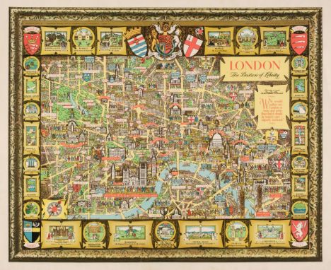
Lot 163
London. Lee (Kerry), London. The Bastion of Liberty, circa 1951, colour photolithographic pictorial map of London, very slight marginal finger soiling, 540 x 665 mm QTY: (1)NOTE:A charming self-portrait of the artist Kerry Lee (1902-1988) can be seen in the lower right corner, his name signed on an easel with his faithful dog Jim sitting by his side. Kerry Lee produced two colour pictorial maps for British Railways in the 1930s which were revised up until the 1950s. These railway posters are very much in the style of Macdonald Gill.

Lot 164
London. Walker (J. & C.), A Plan of London and its Environs, published for Lewis's Topographical Dictionary, circa 1845, uncoloured engraved map, old folds, slight spotting and offsetting, 400 x 470 mm, together with Morden (Robert). England & Wiltshire [1695 or later], two uncoloured engraved maps, some creasing to the map of England, each approximately 365 x 420 mm, with Cumberlege (S. A. publisher). The Island of Minorca, 1781, uncoloured engraved map, inset map of the Harbour of Mahon, old folds, 190 x 230 mm, QTY: (4)

Lot 165
London. Wyld (James), Wyld's new Plan of London and its Vicinity, circa 1880, lithographic map with contemporary outline colouring, sectionalised and laid on later linen, marbled endpapers, 575 x 760 mm, contained in a contemporary cloth slipcase with publisher's printed label to the upper cover, very slight wear to the extremitiesQTY: (1)
Lot 167
Map Reference. A collection of approximately 95 reference books and facsimile atlases, 20th century, including reference books by Moreland & Bannister, Tooley, Barron, Baynton-Williams, Booth, Skelton, Chubb and Lister, together with facsimile atlases after Blaeu, Braun & Hogenberg, Owen & Bowen, Pigot, Moule, Speed and Bickham, occasional duplicates, with The Map Collector. A broken run, numbers 2, 6, 16, 31, 39 - 45, & 47 - 74, March 1978 - Spring 1996, numerous colour and black & white illustrations throughout, all with original publisher's printed wrappers, plus five earlier volumes on British topography and maps, including John Cary's 'Itinerary', various sizes and conditionQTY: (approx. 135)

Lot 171
* Merionethshire. Speed (John), Merionethshire, Described, George Humble, circa 1627, hand-coloured engraved map, large strapwork cartouche, mileage scale and compass rose, very slight text show through, 3680 x 505 mm, mounted, framed and glazed, together with Saxton (Christopher & Hole G.). Cestriae Comitatus Romans Legionibus et Coloniss olim insignia vera et absolute descriptio, circa 1610, hand-coloured engraved map, large strapwork cartouche, slight creasing, 260 x 310 mm, framed and glazed, with Saxton (Christopher & Kip W.). Denbigh Comitatus pars olim Ordovicum, circa 1610, hand-coloured engraved map, large strapwork cartouche and mileage scale, 260 x 315 mm, mounted, framed and glazedQTY: (3)

Lot 172
* Middlesex. Speed (John & Norden John), Midle-Sex described with the most Famous Cities of London and Westminster, George Humble [1616], hand-coloured engraved map, inset city views of Westminster and London and two inset views of Saint Peters and Saint Pauls, central fold partially repaired on verso, 385 x 510 mm, mounted, framed and double glazed, Latin text on versoQTY: (1)
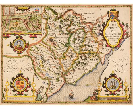
Lot 173
Monmouthshire. Speed (John), The Countye of Monmouth with the situation of the Shire-towne Described, John Sudbury & George Humble, 1st edition [1611], hand-coloured engraved map, inset town plan of Monmouth, large strapwork cartouche and mileage scale, some repaired marginal closed tears but not affecting the printed image, central fold strengthened on verso, slight creasing, 385 x 515 mm, English text on versoQTY: (1)

Lot 174
New Zealand. Wyld (James), To the Right Honourable the Secretary of State for the Colonies, &c. &c. &c., This Chart of New Zealand, from Original Surveys is Respectfully Dedicated by his Very Obedient Servant, circa 1875, uncoloured lithographic map, inset maps of Bar and Part of Hokianga River; Entrance to Port Manoukao; Plan of Victoria; Port Nicholson; Plan of Southern Port, Stewart's Island [and] Plan of Dusky Bay, old folds with occasional small holes where folds cross, some toning to folds, laid on later linen, 785 x 540 mm, together with Map of Australia Compiled from the Nautical Surveys made by order of the Admiralty and other Authentic Documents, circa 1875, uncoloured lithographic map, inset maps of Van Diemans Land and the world on a Mercator projection, old folds with occasional small holes where folds cross, some toning to folds, laid on later linen, 560 x 805 mmQTY: (2)

Lot 175
* Norfolk. Speed (John), Norfolk a Countie florishing & populous described and devided with the armes of such noble familes as have borne the titles therof, published John Sudbury & George Humble, [1616], hand-coloured engraved map, inset city plan of Norwich, slight staining to the lower margin, 375 x 505 mm, mounted, framed and double-glazed, Latin text on versoQTY: (1)
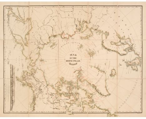
Lot 176
North Pole. Bauman (William). Map of the North Polar Region, circa 1876, colour lithographic map, sectionalised and laid on linen, inset prospect of Wrangell Land, marbled endpapers, 635 x 800 mm, together with Jefferys (Thomas). A Map of Bengal and its Dependencies Collected chiefly from actual Surveys and first Published according to Act of Parliament the 1st Jany. 1772 by W. Bolts, circa 1773, uncoloured engraved map, old folds, one repaired closed handling tear, slight offsetting, 400 x 560 mm, with Murray (John, publisher). A Chart of the River Zaire. The lower part from the Mouth to Embomma..., 1817, uncoloured engraved map, old folds, inset map of the coast from Cape Lopez, two horizon profiles, some offsetting, 340 x 500 mmQTY: (3)
![North Wales. Speed (John), Montgomery, Flint & Denbighshire..., [1611 - 27], three county maps, including Montgomery Shir](https://cdn.globalauctionplatform.com/f2d55b0d-bea0-4ba1-96c5-af5f00b8a264/99f5e414-f0f9-4c17-b2e3-af5f011de9ef/468x382.jpg)
Lot 177
North Wales. Speed (John), Montgomery, Flint & Denbighshire..., [1611 - 27], three county maps, including Montgomery Shire, 1st edition, John Sudbury & George Humble [1611], hand-coloured engraved map, inset town plan of Montgomery, large strapwork cartouche, mileages scale and compass rose, some marginal fraying, vertical margins extended, central fold strengthened on verso, 385 x 510 mm, English text on verso, together with Denbigh Shire, John Sudbury & George Humble, circa 1627, hand coloured engraved map, inset town plan of Denbigh, slight creasing, central fold and lower margin strengthened on verso, 380 x 510 mm, English text on verso, with Flint-Shire, John Sudbury & George Humble, circa 1627, hand coloured engraved map, inset town plans of Flint and St Asaph and a vignette view of St Winifred's Well, slight staining, occasional repaired marginal closed tears, central fold repaired and strengthened on verso, 385 x 515 mm, English text on versoQTY: (3)
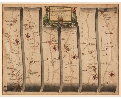
Lot 179
* Ogilby (John). The Road from Bristol co. Glouc. to Banbury com. Oxon. circa 1698, hand-coloured engraved strip road map, some spotting and toning, 330 x 440 mm, mounted, framed and glazed, together with Morden (Robert). Warwickshire [and] Cumberland [1695 or later], two hand-coloured engraved maps, Cumberland toned and with some tape staining, each approximately 365 x 425 mm, framed and glazed, with Saxton (Christopher & Hole G.). Eboracensis Comitatis pars Occidentalis vulgo West Riding [1637], hand-coloured engraved map, strapwork cartouche, 265 x 320 mm, mounted, framed and glazed, plus Moule (Thomas). Oxfordshire [and] Norfolk], circa 1845, two hand-coloured engraved maps, Norfolk laid on later card, Oxfordshire with an old fold, each approximately 265 x 205 mm, framed and glazed, and a facsimile Thomas Moule map of GloucestershireQTY: (7)NOTE:The John Ogilby map is sheet 55. it commences at Bristol and passes through Chipping Sodbury, Tetbury, Cirencester, Barnsley, Burford, Shipton-under-Wychwood and Bloxham and ends at Banbury.

Lot 180
* Ortelius (Abraham). Alexandri Magni Macedonis Expeditio, Antwerp, circa 1624, hand-coloured engraved map, inset view of the temple of the oracle of Jupiter Amman in Libya, slight creasing, 360 x 460 mm, mounted, framed and glazedQTY: (1)NOTE:Marcel van den Broecke. Ortelius Atlas Maps, number 222. originally published in 'The Parergon'.
Lot 181
* Oxford, Buckinghamshire & Berkshire. Saxton (Christopher), Oxonii Buckinghamiae et Berceriae Comitatum una cum suis undiq confinibus, oppidis, pagis, villis, et fluminibus in eisdem vera descriptio. An Dm 1574 [1579], engraved map with contemporary hand colouring, strapwork cartouche and a mileage scale surmounted by a pair of dividers, with the heraldic crest of Thomas Seckford, slight creasing, very slight spotting, 390 x 445 mm, mounted, framed and glazedQTY: (1)NOTE:The first printed map of Oxford, Buckinghamshire and Berkshire.
Lot 182
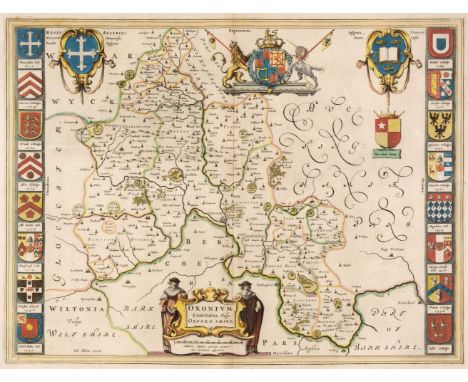
* Oxfordshire. Blaeu (Johannes), Oxonium Comitatus vulgo Oxford Shire, Amsterdam, circa 1646, engraved map with contemporary outline colouring, decorative cartouche and mileage scale, sixteen heraldic shields of Oxford University colleges to the vertical margins, engraved vignette of the Rollright stones on verso, 385 x 505 mm, mounted, framed and double-glazed, Dutch text on versoQTY: (1)
Lot 183
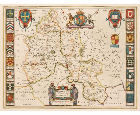
Oxfordshire. Blaeu (Johannes), Oxonium Comitatus vulgo Oxford Shire, Amsterdam, circa 1646, engraved map with contemporary outline colouring, decorative cartouche and mileage scale, sixteen heraldic shields of Oxford University colleges to vertical margins, engraved vignette of the Rollright stones on verso, 385 x 505 mm, French text on the versoQTY: (1)

Lot 184
Patagonia. Blaeu (Willem Janszoon), Freti Magellanici ac novi Freti vulgo Le Maire exactissima delineatio, Amsterdam, circa 1640, engraved map with contemporary outline colouring, slight staining and dust soiling, margins strengthened and extended on the recto, one crudely repaired hole in the margin but not affecting the printed image, 370 x 490 mm, no text on verso, together with Thomson (John & Co. publisher). Map of the Islands of the Pacific Ocean, circa 1817, engraved map with contemporary outline colouring, central fold strengthened on verso, lower margin extended and repaired on the recto, 495 x 605 mmQTY: (2)

Lot 186
* Pembrokeshire. Speed (John), Penbrokshyre described and the Sittuations both of Penbroke and St. Davids shewed in due form as they were taken, 1st edition, John Sudbury & George Humble [1611], hand-coloured engraved map, inset town plans of Penbroke and Saint Davids, 385 x 500 mm, framed and double-glazed, English text on versoQTY: (1)

Lot 189
Rapkin (J.). A collection of 49 maps, circa 1860, engraved maps with contemporary outline colouring and some later enhancement, some duplicates, some maps dust and finger soiled, a few maps trimmed with slight loss to the decorative margins, map of Ireland with long closed tear, crudely repaired, some duplicates, together with the title page to the Montgomery Martin atlas, each approximately 350 x 250 mmQTY: (50)NOTE:The maps consist of Western Australia Swan River, Part of South Australia, Ireland, Southern Italy, Japan & Corea, The World on Mercators Projection, East Canada and New Brunswick (3), Austria (2), Turkey in Europe (3), Turkey in Asia, Belgium (2), Asia Minor, Western Africa (2), Independent Tartary (5), Central America, Prussia, Thibet Mongolia and Mandchouria, Peru & Bolivia, Northern India, British Possessions in the Mediterranean (2), Russia in Europe, Russia in Asia, Sweden and Norway, British Guayana (6), Denmark, Baltic Sea, The Crimea, Hungary, Black Sea, Natal and Kaffraria, Venezuela New Granada Equador and the Guayanas [and] Northern Africa.
Lot 19
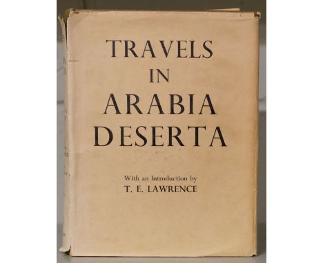
Doughty (Charles M.). Travels in Arabia Deserta, with an introduction by T. E. Lawrence, new and definitive edition, 2 volumes, London: Johnathan Cape, 1936, maps and illustrations, original cloth (head of volume I spine faded), dust jackets, spines faded, a few chips and tears, 4to, together with Iraq and the Persian Gulf, B.R. 524 (Restricted) Geographical Handbook Series, Naval Intelligence Division, September 1944, numerous folding maps and half-tone illustrations, one folding map contained in rear pocket, bookplate, original cloth, spine and part of upper cover faded, 8vo, plus Guarmani (Carlo). Northern Najd. A Journey from Jerusalem to Anaiza in Qasim, translated from the Italian by Lady Capel-Cure, London: Argonaut Press, 1938, folding map contained in rear pocket, illustrations, original cloth-backed boards, one or two small marks, 4to, with others related including Arabia, HM Stationary Office, 1920, Seven Pillars of Wisdom, 1935, and Arabian Adventure to the Great Nafud in Quest of the Oryx, by Douglas Carruthers, 1935QTY: (19)
Lot 190
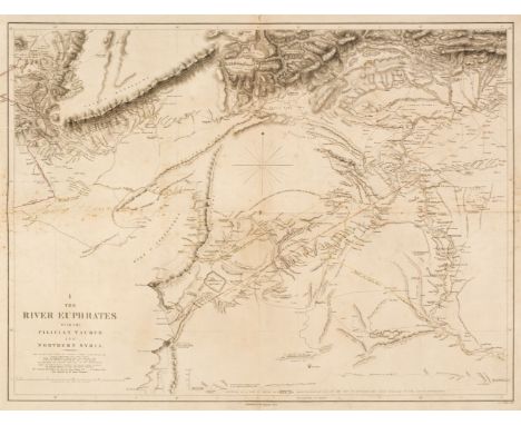
River Euphrates. Chesny (Colonel Francis Rawson, surveyor), Twelve map sheets, 1849, twelve double-page maps, engraved by J & C Walker, slight spotting, old folds, backed with near-contemporary silk, each approximately 475 x 630 mmQTY: (12)NOTE:The Euphrates expedition was led by a British army officer, Colonel Francis Rawson Chesney. The main objective was to establish a route “between the Mediterranean Sea and His Majesty’s possessions in the East Indies by means of a steam communication of the river Euphrates”. Finding a shorter route to India was the hot topic of the time. The East India Company particularly, needed a solution to cut down the travel time between England and India. Chesney was involved in initial surveys in Egypt and the Middle East in the late 1820s where he had investigated the possibility of passage to India via the Red Sea and in 1829, submitted a report advocating the construction of the Suez Canal. He also brought to attention the feasibility of steam communication with India through the Euphrates. King William IV himself expressed a desire that the route by the Euphrates to India should be put to a practical test. The main task involved determining the depth, current and state of the river and this wealth of data was used in the compilation of detailed charts of the region’s waterways from the Mediterranean to the Persian Gulf.The Euphrates project was shelved and the shorter route to India was eventually established in late 1869 via the Suez Canal. Nevertheless, Chesney’s survey proved an invaluable source of information on the region’s hydrography.
![* Scotland. Speed (John), The Kingdome of Scotland, Thomas Bassett & Richard Chiswell [1676], hand-coloured engraved map,](https://cdn.globalauctionplatform.com/f2d55b0d-bea0-4ba1-96c5-af5f00b8a264/ade89f6d-b516-493d-8e2c-af5f011df647/468x382.jpg)
Lot 192
* Scotland. Speed (John), The Kingdome of Scotland, Thomas Bassett & Richard Chiswell [1676], hand-coloured engraved map, inset map of the Orkney Islands, four costumed figures to the vertical margins, slight staining to central fold, a little dust soiled, 385 x 515 mm, framed and double-glazed, English text on versoQTY: (1)
![Second Geological Survey of Pennsylvania. Grand Atlas Division I, II [2 parts], III, IV, [and] V, 6 portfolios (complete), Ha](https://cdn.globalauctionplatform.com/f2d55b0d-bea0-4ba1-96c5-af5f00b8a264/d8b108c8-8f5b-47a2-adac-af5f011df715/468x382.jpg)
Lot 193
Second Geological Survey of Pennsylvania. Grand Atlas Division I, II [2 parts], III, IV, [and] V, 6 portfolios (complete), Harrisburg, 1885, a complete set of mostly coloured lithographed maps on 201 sheets, loosely contained as issued with title-page in original cloth portfolios, double elephant folio (68 x 81cm / 27 x 32ins)QTY: (6)NOTE:The Second Geological Survey began after the Civil War and was overseen by J.P. Lesley, who became State geologist in 1874. This impressive work is one of the most ambitious and comprehensive geological surveys undertaken by any state and is scarce as a complete collection in good condition. Highlights of the set include 49 coloured geological maps of most counties in Pennsylvania, as well as maps from the oil regions. The six portfolios are titled: 1) Grand Atlas Division I. County Geological Maps (56 counties, 49 sheets). 2) Grand Atlas Division II. Anthracite Coal Fields Part 1. Eastern Ends of the Western Middle and Southern Fields in Carbon, Schuylkill, Columbia and Northumberland Counties (26 sheets). 3) Grand Atlas Division II. Anthracite Coal Fields Part 2. Portions of the Northern and Eastern Middle Fields in Luzerne County (22 sheets). 4) Grand Atlas Division III. Petroleum and Bituminous Coal Fields. Portions of the Petroleum and Bituminous Coal Fields and Three Sheets Relating To The Quaternary Period (35 sheets). 5) Grand Atlas Division IV. South Mountain and Great Valley Topographical Maps. Thirty Sheets Relating to the Durham and Reading Hills and Bordering Valleys in Northampton, Lehigh, Bucks and Berks Counties, and thirteen sheets relating to the South Mountains in Adams, Franklin, Cumberland and York Counties (34 sheets, 9 not published). 6) Grand Atlas Division V. Central and South-Eastern Pennsylvania. Twenty-Nine Sheets Related to the Topography and Geology of the Paleozoic Strata in parts of Cambria, Blair, Bedford, Huntingdon, Mifflin, Centre and Union Counties. Five sheets contain a map and geological cross-section along the east bank of the Susquehanna River, Lancaster County. One sheet contains cross-sections of the Philadelphia Belt of Azoic Rocks (35 sheets).

Lot 195
Spain & Portugal. Mentelle (Edme, & Chanlaire, P. G.), Map of Spain and Portugal, John Stockdale, 1808, engraved frontispiece index map with contemporary wash colouring, printed titlepage, nine double-page engraved sheets with contemporary outline colouring, some near-contemporary ink marginalia and annotations, slight staining, contemporary half morocco with publisher's printed label to the upper cover, worn, rubbed and rebacked, slim folioQTY: (1)

Lot 196
Sri Lanka. MacDonald Gill (Leslie), Map of Ceylon showing her Tea and other Industries, Ceylon Tea Centre, circa 1933, colour lithographic pictorial map, some creasing, slight toning, very slight spotting to the margins, 750 x 465 mmQTY: (1)NOTE:This highly decorative map of Ceylon was produced in two sizes, this being the smaller of the two editions.
Lot 197
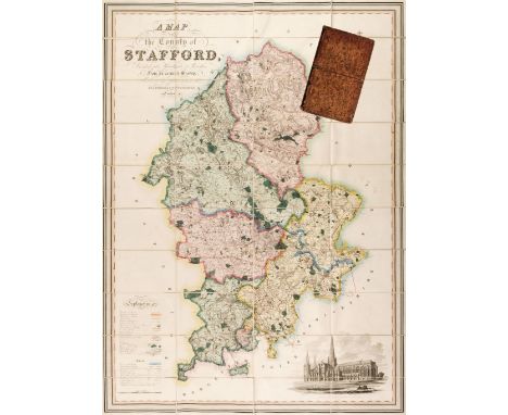
Staffordshire. Phillips (J. & Hutchings W.F.), A Map of the County of Stafford Divided into Hundreds & Parishes from an accurate Survey, made in the Years 1831 and 1832, Henry Teesdale, 1st August 1832, large scale map engraved by J. Dower with bright contemporary wash colouring, calligraphic cartouche, compass rose, table of explanation, inset uncoloured vignette of Lichfield Cathedral, edged in green silk, 1335 x 975 mm, marbled endpapers, contained in a contemporary blind-stamped tree calf book box with contrasting red gilt morocco label to the spine, worn and rubbedQTY: (1)


Lot 199
* Sussex. Speed (John & Norden John)), Sussex Described and divided into Rapes, with the situation of Chichester the cheife citie thereof and the armes of such nobles as have bene dignified with the title of Earles since the conquest and other accidents therein observed, George Humble, circa 1646, engraved map with contemporary hand colouring, inset city plan of Chichester, central fold strengthened on verso, slight browning and offsetting, 380 x 505 mm, framed and double-glazed, English text on versoQTY: (1)NOTE:Scarce with contemporary colouring.
Lot 200
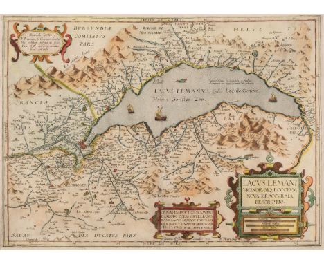
* Switzerland. Le Clerc (Jean), Lacus Lemani Vicinorumq Locorum Nova et Accuraia Descriptio, Paris, 1619, hand-coloured map of the country around Lake Geneva, engraved by H. Picart, slight creasing, 355x 495 mm, mounted, framed and glazedQTY: (1)NOTE:A rare edition of Johann Baptiste Vrients map of the region around Lake Geneva, which was first published in the 1603 edition of Ortelius's 'Theatrum Orbis Terrarum'. Despite the similarity, Le Clerc has engraved an entirely new plate. The map was also later copied by both H. Hondius and Melchior Tavernier. Copac lists only two copies (Oxford University and the British Library) and there is a third example in the Bibliotheque National de France.

Lot 201
* Switzerland. Muster (Sebastian), La Noble Ville de Geneve avec la Situation, circa 1580, hand-coloured woodblock panorama with French text below the image, slight staining to the lower margin, 260 x 370 mm, mounted, framed and glazed, together with Cluver (Philip). Helvetia Contermin arumq. terrarum antiqua [1697], hand-coloured engraved map, 200 x 255 mm, mounted, framed and glazed, with Hondius (Jodicus & Jansson Jan). Nova Helvetia Tabula, circa 1628, hand-coloured engraved map, 145 x 195 mm, mounted, framed and glazedQTY: (3)
![* Switzerland. Ortelius (Abraham), Helvetiae Descriptio Aegidio Tschudo Auct. [1570 or later], hand-coloured engraved map, 's](https://cdn.globalauctionplatform.com/f2d55b0d-bea0-4ba1-96c5-af5f00b8a264/eb1500ce-1b61-496e-902c-af5f011dff28/468x382.jpg)
![Tartary. Speed (John), A Newe Mape of Tartary augmented by John Speede..., 1626, George Humble [1627], hand-coloured engraved](https://cdn.globalauctionplatform.com/f2d55b0d-bea0-4ba1-96c5-af5f00b8a264/c1821773-ff07-4c03-8a01-af5f011e001f/468x382.jpg)
Lot 203
Tartary. Speed (John), A Newe Mape of Tartary augmented by John Speede..., 1626, George Humble [1627], hand-coloured engraved 'carte-a-figures' map, four oval vignettes of principal cities along the upper margin, eight costumed figures to the vertical margins, very slight marginal staining and fraying, 395 x 515 mm, English text on versoQTY: (1)

Lot 206
United States. Bye (J.), Map of the United States of North America for Volney's View of the Climate and Soil of the United States, 1804, uncoloured engraved map, slight spotting and toning, old folds, 430 x 540 mm, together with Stockdale (J.). Part of the United States of North America, 1798, uncoloured engraved map, inset map of North Carolina, old folds strengthened and repaired on verso, slight toning and offsetting, short split along one fold, 410 x 465 mm, with Wyld (James). United States of America, circa 1850, engraved map with contemporary wash colouring, inset map of the British Isles, old folds, laid on later linen, 380 x 540 mmQTY: (3)

Lot 207
United States. Poirson (Jean Baptiste), Carte des Deux Florides et la Louisiane Inférieure, Dresée pour les Voyages de Mr. Robin dans les Années 1802, 1803, 1804, 1805 et 1806..., Paris, 1807, engraved map with contemporary outline colouring, old folds, slight staining, 415 x 675 mm, together with Neele & Son. Map of part of the United States of North America with the Territory of the Illinois on Ohio, particularly designed to illustrate Birkbeck's Journey, J. Ridgeway, 1818, engraved map with contemporary outline colouring, old folds, slight offsetting, one repaired closed handling tear, old folds repaired and strengthened on verso, 325 x 405 mm, with La Rochefoucauld - Liancourt (Francois). Carte des Etats-Unis provinces Septentrionales, Paris, circa 1799, uncoloured engraved map, old folds, slight offsetting, 325 x 510 mmQTY: (3)

Lot 208
* Wales. Ortelius (Abraham & Lhuyd Humphrey), Cambriae Typus Auctore Humfredo Lhuydo Denbigiense Cambrobritano, circa 1612, engraved map with near-contemporary outline colouring, large strapwork cartouche, 370 x 500 mm, mounted, framed and double-glazed, Latin text on versoQTY: (1)NOTE:Marcel van den Broecke. Ortelius Atlas Maps, number 21 (State 2). John Booth. The Antique Maps of Wales, number 2.
![* Wales. Speed (John), Caermarden Both Shyre and Towne Described, John Sudbury & George Humble [1627], hand-coloured engr](https://cdn.globalauctionplatform.com/f2d55b0d-bea0-4ba1-96c5-af5f00b8a264/9a552261-fde4-4af4-a6f7-af5f011e04fe/468x382.jpg)
Lot 209
* Wales. Speed (John), Caermarden Both Shyre and Towne Described, John Sudbury & George Humble [1627], hand-coloured engraved map, inset town plan of Carmarthen, large strapwork cartouche, compass rose and mileage scale, two very small rust holes, 380 x 510 mm, framed and double-glazed, English text on verso, together with The Countie of Radnor Described and the Shyre Townes Sittuatione, John Sudbury & George Humble, circa 1627, uncoloured engraved map, inset town plan of Radnor, large strapwork cartouche and mileage scale, slight staining and dust soiling, 385 x 515 mm, framed and double-glazed, English text on verso, together with Jansson (Jan). Radnoriensis comitatus vulgo The Countie of Radnor, Amsterdam, circa 1650, engraved map with contemporary outline colouring, later green crayon annotations (possibly roads), some creasing, slight overall toning, 370 x 480 mm, no text on verso, with Morden (Robert). South Wales [1695 or later], uncoloured engraved map central fold repaired on verso, 365 x 435 mm, with another coloured example, mounted, with another 21 maps of Welsh counties and regions, including examples by or after Kitchin, Badeslade & Toms, Cary, Seller/Grose, Saxton/Kip and Rocque, various sizes and condition, several framed and glazedQTY: (26)

Lot 210
* Wales. Speed (John), Wales, John Sudbury & George Humble, circa 1627, hand coloured engraved map, twelve oval vignettes of principal cities to the vertical margins and inset views of Bangor, St. Davids, Llandaff and St Asaph, 385 x 510 mm, mounted, framed and double-glazed, no text on versoQTY: (1)
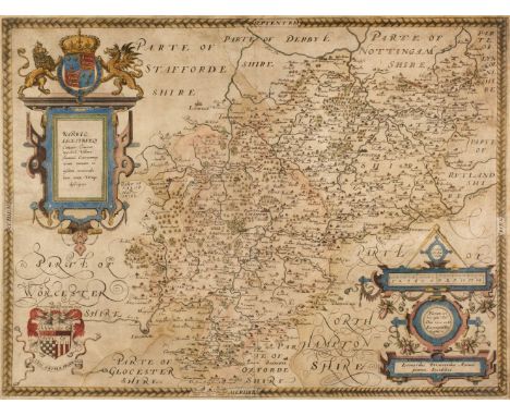
Lot 212
* Warwickshire & Leicestershire. Saxton (Christopher), Warwic Lecestriaeq. Comita Civitat. Oppidoru. Villaru. Fluminu. Ceterarumq. Rerum omnium in eisdem memorabilium, nova, veraq. descriptio [1579], map engraved by Lenaert Terwoort with contemporary hand colouring, large strapwork cartouche surmounted by the English lion and Welsh dragon, ornate strapwork mileage scale with an additional heraldic crest of Thomas Seckford, very slight spotting, 390 x 520 mm, mounted, framed and glazedQTY: (1)NOTE:The first printed map of Warwickshire and Leicestershire. Unusually, for a sixteenth-century map, a road (Watling Street) is clearly marked and named, possibly because the road marked the county boundary.
Lot 213
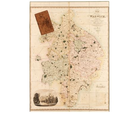
Warwickshire. Greenwood (C. & J.). Map of the County of Warwick from actual Survey, made in the years 1820 & 1821, Dedicated to the Nobility, Clergy & Gentry of the County by the Proprietors and Published for them by George Pringle Junr. C. & J. Greenwood. 1822, large-scale engraved map with contemporary wash colouring, sectionalised and laid on linen, calligraphic title, table of explanation, compass rose and uncoloured vignette of Warwick castle, very slight offsetting, edged in green linen, 1320 x 1050 mm, marbled endpapers, contained in a contemporary tree calf book box, some wear to extremitiesQTY: (1)
Lot 214
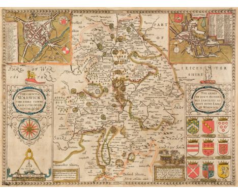
* Warwickshire. Speed (John), The Counti of Warwick, The Shire Towne and Citie of Coventre described, Roger Rea 1662, engraved map with contemporary outline colouring, inset city plans of Warwick and Coventry, large strapwork cartouche, compass rose and mileage scale, 385 x 510 mm, mounted, framed and double-glazed, English text on versoQTY: (1)NOTE:Scarce with contemporary colouring.

Lot 215
World. Gill (Macdonald). The "Time and Tide" Map of the Atlantic Charter, George Philip and Son Ltd, 1944, large colour photolithographic map, slight creasing, old folds, some wear to folds on verso with very small splits and tears, 800 x 1095 mm.QTY: (1)NOTE:Gill's 'Time and Tide' map was commissioned by Time and Tide magazine. It never enjoyed a large circulation and is therefore one of the scarcest of Gill's pictorial maps. The map celebrates the joint declaration released by Churchill and Roosevelt in August 1941 after the Atlantic Conference. The Atlantic Charter was a gesture of solidarity at a moment when Nazi Germany had just turned against the USSR and looked all but invincible. In time the charter would form the basis for Allied war aims and the postwar foundation of the United Nations. Gill takes an optimistic view of the Charter and of the future. He shows a muscled worker taking a sledgehammer to tanks and munitions in the foreground, while in the distance is an idyllic scene of ploughing and reaping. A nod to the book of Isaiah and the turning of 'swords to ploughshares'. The map is adorned with quotes by Cicero, Emerson, Pope and Aristotle on the virtues of peace. Gill is probably best known for his 1913 'Wonderground map of London' and this map is still very much in the decorative and pictorial style that Gill became famous for.
Lot 216
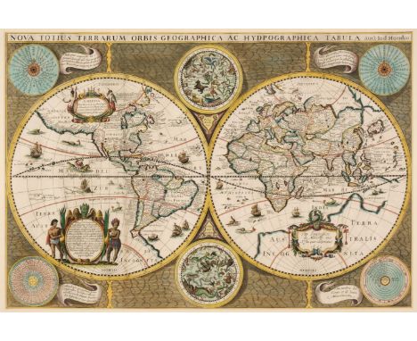
* World. Hondius ( Jodocus & Marriette, Pierre), Nova Totius Terrarum Orbis Geographica ac Hydpographica (sic) Tabula auct: Jud Hondio, Paris 1642 [1643], hand-coloured engraved map on a hemispheral projection, six additional spheres including celestial, wind, zodiacal and a perpetual calendar, a note on the verso of the frame states that the map has been stabilised with Japanese paper, 375 x 555 mm, mounted, framed and glazed QTY: (1)NOTE:R. W. Shirley. The Mapping of the World, number 358. The map is very similar to the Hondius-Berey Map (Shirley 354) but lacks the two ovals which flank the upper celestial sphere. There are two states of this map. One has the imprint of the publisher Pierre Mariette (this example) and can be found in Mariette's atlases from 1643. The other is undated and was published under the name of Niclas Langlois.
Lot 218
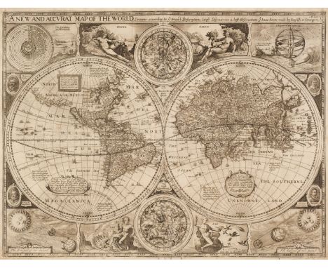
World. Speed (John), A new and Accurat Map of the World. Drawne according to ye truest Descriptions, latest Discoveries & best Observations y't have beene made by English or Strangers, George Humble [1627], uncoloured engraved map of the world on a hemispheral projection, two further circular astrological projections, the map surrounded by portraits of explorers, allegorical depictions of the four elements and celestial diagrams, insular California, slight creasing, margins frayed and chipped with occasional marginal closed tears, 395 x 515 mm, English text on verso QTY: (1)NOTE:R. W. Shirley, The Mapping of the World, number 317.

Lot 219
* Yorkshire. Speed (John), The North and East Ridins of Yorkshire, John Sudbury & George Humble, circa 1627, uncoloured engraved map, large strapwork cartouche, inset town plans of Hull and Richmond, very slight spotting, 395 x 520 mm, mounted, framed and double-glazed, English text on verso, QTY: (1)
Lot 22
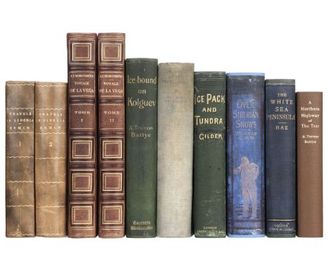
Erman (Adolph). Travels in Siberia: including excursions northwards, down the Ori, to the Polar Circle, and southwards, to the Chinese frontier, 1st edition in English, 2 volumes, London: Longman, Brown, Green, and Longmans, 1848, 2 folding maps to volume 1 (1 loose), bookplates of Clinton E Geiser to front pastedowns, lightly spotted and toned, contemporary calf gilt, gilt foliate rolls to board margins, rebacked, worn, 8vo, together with:Gilder (William). Ice-Pack and Tundra, 1st edition, London: Sampson Low, Marston, Searle & Rivington, 1883, frontispiece, black and white illustrations throughout (including full-page), bookplate of Clinton E Geiser to front pastedown, advertisements to rear, preliminary leaves damp-stained (also to text block edges), original green pictorial cloth, recased, lightly rubbed, 8vo, withMeignan (Victor). From Paris to Peking over the Siberian snows, 1st edition in English, London: W. Swan Sonnerschein and Co, 1885, frontispiece, large folding map, black and white illustrations, bookplate of Clinton E Geiser to front pastedown, some gatherings damp-stained, some occasional light spotting and soiling, original blue pictorial cloth gilt, recased, lightly rubbed, 8vo, together with 6 others related to Siberian travelQTY: (10)

Lot 23
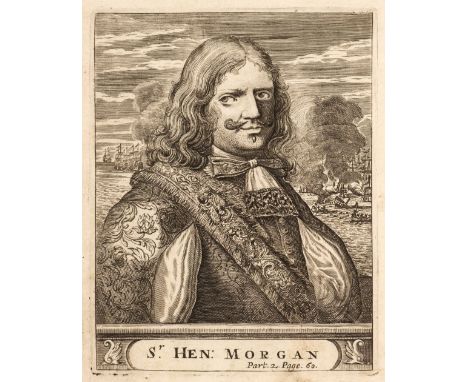
Exquemelin (Alexandre Olivier). Bucaniers of America: Or, a True Account of the most remarkable assaults committed of late years upon the coasts of the West-Indies, by the Bucaniers of Jamaica and Tortuga, both English and French. Wherein are contained more especially, the unparallel'd exploits of Sir Henry Morgan, our English Jamaican hero who sack'd Puerto Velo, burnt Panama &c., 1st edition, 3 parts [of 4], Printed for William Crooke at the Green Dragon, 1684, engraved frontispiece to part 1, incomplete with 2 engraved plates only (folding map of Panama present), ownership inscription of 'Charles Amcotts 1742' to title, occasional light dust-soiling, concomitant wormholes to upper margins of most leaves, endpapers renewed, modern mottled sheep gilt, green morocco title label, 4toQTY: (1)NOTE:Provenance: Charles Amcotts (1729-1777), M.P. for Boston from 1754 to 1777. He inherited Kettlethorpe Hall from his father's step-brother, Charles Hall, who had built the original house in the early 1700s. The cleaning of the moat at Kettlethorpe by its owner the M.P. Douglas Hogg, is now the most famous example of the MPs' expenses scandal which erupted in 2009.
Lot 25
Hall (Captain Charles Francis). Life with the Esquimaux: The Narrative of Captain Charles Francis Hall, of the Whaling Barque "George Henry," from the 29th May, 1860, to the 13th September, 1862, with the results of a long intercourse with the Innuits... and deductions in favour of yet discovering some of the survivors of Sir John Franklin's expedition, 2 volumes, 1st edition, London: Sampson Low, Son, and Marston, 1864, half-titles, engraved frontispiece to first volume, wood-engraved illustrations, folding lithograph map at rear of first volume, Clinton E Geiser to front pastedowns, lightly toned, endpapers renewed, modern black buckram gilt, lightly marked, 8voQTY: (1)
Lot 269
Diogenes Laertius. De vita et moribus philosophorum libri X, Lyon: Seb.Gryphium, 1551, printer's woodcut device to title (adhesive tape to gutter margin & leaf detached from main body of text block), woodcut decorative initials, light damp stain to upper margins, contemporary vellum with yapp fore-edges, upper joint split, lacking ties, 8vo, together with:Shakespeare (William), The Plays... with the corrections and illustrations of various commentators; to which are added notes by Samuel Johnson and George Steevans, 10 volumes, London: C. Bathurst, J. Beecroft, W. Stahan [& others), 1773, engraved portrait frontispiece to first volume, half-titles to volumes 2-10, title to first volume with early signature E. Edwards dated 1771, occasional scattered spotting, armorial bookplate of Revd. J. Brereton D.C.L., contemporary half calf, contrasting morocco labels to spines (some volume number labels lacking), light wear, 8vo,Cocker (Edward), Cocker's English Dictionary, containing an explanation of the most refined and difficult words and terms..., 3rd edition, enlarged and altered by John Hawkins, London: T. Norris and A. Bettesworth, 1724, few ink markings to lower margin of title, occasional light browning and spotting, contemporary sheep, upper joint split and board attachment weak, lower joint cracked, 8vo in 4s,Fuller (Thomas), The Historie of the Holy Warre, Cambridge: Printed by Thomas Buck, one of the Printers to the Universitie of Cambridge, 1639, preliminary leaf entitled "A declaration of the frontispice", additional engraved title-page, without map of the Holy Land and final seven leaves of chronological tables and index (leaves 2P4 & 2Q1-2Q6), contemporary calf, spine torn with loss and upper board detached, small folio (STC 11464)QTY: (13)
Lot 27
Hearne (Samuel). A Journey from Prince of Wales's Fort in Hudson's Bay, to the Northern Ocean. Undertaken by Order of the Hudson's Bay Company, for the Discovery of Copper Mines, a North-West Passage, &c. in the Years 1769, 1770, 1771 & 1772, 1st edition, London: printed for A. Strahan and T. Cadell, 1795, 5 folding engraved maps, 4 folding engraved plates, large folding map at front with outline colour and small repairs to verso, some spotting and small marginal stains. p. 456 with small annotations to gutter, contemporary previous owner signature to title, hinges reinforced, contemporary tree calf, joints split, spine rubbed with losses at ends, a little rubbed with some edge wear, 4toQTY: (1)NOTE:ESTC T146967; Hill I p. 141; Sabin 31181. "It was the first of a long series of Arctic voyages and travels which reflect much honor on the British press. Its publication is due to the celebrated explorer La Perouse who captured Fort Albany, Hudson's Bay and found the MS. of Hearne. The fort was afterwards surrendered to the British but La Perouse stipulated for the publication of this work by the Hudson's Bay Company, which stipulation was honorably fulfilled in this beautiful volume... The author will always be remembered as the first white man that ever gazed on the dreary expanse of the Arctic or Frozen Ocean from the northern shores of the Continent of America" (Sabin).
![Bible [New Testament]. [The New Testament of our Lord Jesus Christ, translated out of Greeke by Theod. Beza..., London: Chris](https://cdn.globalauctionplatform.com/f2d55b0d-bea0-4ba1-96c5-af5f00b8a264/8dd0f7ea-4ea6-4216-aede-af69010af7fe/468x382.jpg)
Lot 270
Bible [New Testament]. [The New Testament of our Lord Jesus Christ, translated out of Greeke by Theod. Beza..., London: Christopher Barker, 1580?], lacking title and one other preliminary leaf (ai & aii), also lacking final leaf 3H4, full-page woodcut map present, some dust-soiling, light damp stains, first & last few leaves with light marginal fraying, without endpapers, contemporary calf, upper joint split, light wear, 8voQTY: (1)NOTE:Herbert 167; Darlow & Moule 126.
![Bible [English]. The Holy Bible, containing the Old Testament and the New: Newly translated out of the Originall Tongues: and](https://cdn.globalauctionplatform.com/f2d55b0d-bea0-4ba1-96c5-af5f00b8a264/6aeafe94-d50f-4425-a233-af5f011e2f24/468x382.jpg)
Lot 273
Bible [English]. The Holy Bible, containing the Old Testament and the New: Newly translated out of the Originall Tongues: and with the former translations diligently compared and revised, by his Maiesties speciall commandement, Appointed to be read in Churches, Imprinted at London by Robert Barker and John Bill, 1630, general and New Testament titles within decorative woodcut border (general title with ink mark to small area of woodcut border), Apocrypha present, black letter text in double-column, lacking final leaf of Malachi (2S5), bound without leaves 3P1-3Q8, and bound without genealogies and map, close trimming at head and foot with cropping to few running titles and few catchwords etc., H2 torn at foot with slight loss, lower outer corner of 2F6 torn away with slight loss mostly to marginal note and catchword, 3E5 torn to blank fore-margin, short worm trails to gutter margins, few other occasional minor trails to fore-margins to few leaves at rear of volume, some dust-soiling (mostly light) and marks, some leaves with light damp stains to lower margins, early 19th-century calf, rebacked preserving original spine, 4to in 8s (20.5 x 16 cm)QTY: (1)NOTE:Herbert 430; Darlow & Moule 329; STC 2290.Wisdom of Solomon xix. 22: neither diddest thou...
-
109182 item(s)/page