We found 109182 price guide item(s) matching your search
There are 109182 lots that match your search criteria. Subscribe now to get instant access to the full price guide service.
Click here to subscribe- List
- Grid
-
109182 item(s)/page


Lot 184
DE VALERA, EAMON. Taoiseach's Broadcast to the Nation. Reprinted from The Irish Press, Thursday 17th May 1945. Dublin: 1945, quarto, with reproduced photo of De Valera at the microphone. Dev's celebrated reply to Churchill’s complaint about Irish neutrality during the War - in terms of popular support, perhaps his finest hour; together with The Partition of Ireland, address by Eamon de Valera, T.D. at The Stadium, Liverpool on Sunday, 10th October, 1948, under the auspices of the Liverpool and Lancashire Area Council Anti-Partition of Ireland League. Souvenir Programme, Belfast Irish News, 1948, printed on green, white and gold wrappers, includes a map of Ireland showing partition boundaries, various articles, and the words of 'The Soldier's Song'. (2)

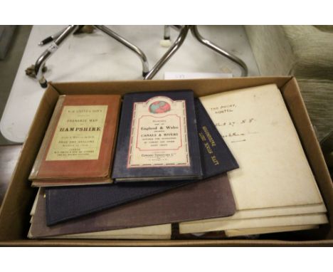
![PETTIGREW & OULTON [Dublin] Almanack, Registry and Directory for 1836, with map; together with another for 1838. (2)](https://cdn.globalauctionplatform.com/822b3a51-8dbd-476e-8187-a8be00c17e4b/aa756dac-20de-43cd-dba2-17b788340c95/468x382.jpg)


Lot 42
ROCQUE'S MAP OF ARMAGH A Topographical Map of the County of ARMAGH to which is Anex'd the PLANS of NEWRY and ARMAGH by John Rocque. Carte Topographique de la Province d'ARMAGH ou Se trouve les Plans des Villes d'ARMAGH et NEWRY par I. Rocque 1760, overall size 1320 x 960 .A four sheet map that has been sectioned into 16 parts and mounted on linen. There is a lengthy dedication contained in a large vignette showing a sarcophagus on which is inscribed 'To the moft Revd. Father in God Richard Lord Archbishop of Armagh Primate and Metropolitan of all Ireland This Survey of the County of Armagh Is humbly infcribed by His Graces Moft obedient humble Servant John Rocque.' The side of the structure bears the Archbishop's coat of arms. To the left, four cherubs cavort around a monument amongst implements representing the arts and sciences. In addition to this there is at top left 'A PLAN of the TOWN of NEWRY Situated in the county's of DOWN and ARMAGH' this inset is separated from main map. The map has the imprint of Laurie & Whittle, who purchased the plates from Sayer, who in turn had probably bought them from Mary, Rocque's widow.. This state would have been printed c1794.

Lot 43
A NEW MAP OF THE SEAT OF WAR, comprehending Germany; Poland, with its Dismemberments, Prussia; Turkey in Europe, Italy &c, from the Maps of Chauchard, Zannoni, &c. London, published by Laurie & Whitle, 1813, hand coloured, scale in German, Hungarian, and British miles; French Leagues, Italian and Geographic miles, with decorative cartouche. 810 x 720mm.
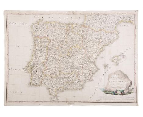
Lot 44
MAP OF SPAIN AND PORTUGAL, divided into their respective Kingdoms and Provinces, from the Spanish and Portuguese Provincial Maps, London, Faden, June 4th 1796, scales in Spanish and Portuguese Leagues, Castilian Legal Leagues, Italian Miles, and English Statute Miles, with decorative cartouche, repair to some minor tears. 740 x 530mm


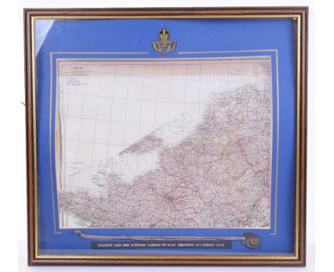
Lot 324
Royal Air Force Aircrew Issue Tissue Paper Escape Map and Escape Compass, interesting example of the tissue escape map as issued to RAF aircrew during operations over northern Europe. The map covers Holland, Belgium and Northern France. Mounted in a glazed display frame with an original Aircrew issue escape compass in waterproof cover with neck strap. Also mounted with an RAF NCO’s cap badge. Frame measures 65 x 60cms.

Lot 326
Royal Air Force Aircrew Issue Silk Map, coloured example, covering Norway (South) and Sweden (Part Of) to one side and the other side Norway (Extreme NE), Sweden (Part Of), Finland (North) U.S.S.R (Murmansk Area), Germany (Sea Board) Denmark and Sweden (South). Accompanied by silk printed double sided USAF Cloth Chart (Map) covering Khatanga River to one side and Obskaya Gulf to the other. Both remain in good condition. (2 items)

Lot 327
WW2 AAF Cloth Aircrew Map of Japan and South China Seas No C-52 with No C-53 East China Sea to the reverse; AAF cloth chart No C-43 Mindanao Island with C-44 North Borneo to reverse; AAF cloth chart Eastern Asia (Otomari) with Eastern Asia (Vladimiro-Aleksandrovskoye) to the reverse; AAF cloth chart Eastern Asia (Pei-P’ing – Peking) with Eastern Asia (Ryojun) on the reverse. All remain in good condition. (4 items)
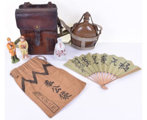
Lot 351
Grouping of WW2 Japanese Military Equipment and Curios, consisting of WW2 Army issue water bottle complete with the original harness and shoulder strap, officers brown lather map case with brass central star and shoulder strap, Japanese soldiers personal property bag with stencilled characters, painted figure of Japanese Kamikaze pilot, painted figure of Japanese officer, Japanese Sake bottle and patriotic paper fan. All in good condition. (7 items)


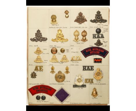
Lot 2
A Collection of Australian Insignia A card of KC and QEC cap and/or collar-badges, buttons and STs of the Royal Australian Artillery, including a good OSD cap and collar of the Siege Brigade; items of the Australian Engineers and Royal Australian Engineers, and a cap-badge and ST of the Royal Australian Survey Corps; a card of cloth and metal "AUSTRALIA" shoulder titles; various patterns of cap and collar-badges of the Australian Commonwealth Military Forces (WW1 and WW2), including a good gilt, white metal and enamel collar-badge of the Commonwealth HQ Staff 1904 - 1921; various buttons with Edward VII and George V cypher, and later buttons bearing map of Australia and inscribed Australian Military Forces; buttons and a fine gilt and enamel collar-badge of the Staff Corps 1920 - 40; KC and QEC badges of the Royal Military College; a card of Mounted Troops and Armoured Corps cloth shoulder-titles, including examples of the New South Wales Lancers, Australian Horse, 10th Light Horse, Second Cavalry Regiment, Hunter River Lancers, Northern Rivers Lancers, Queensland Mounted Infantry, New South Wales Mounted Rifles, Victorian Mounted Rifles (2), West Australian Mounted Infantry and Royal Australian Armoured Corps. Mainly in red embroidery on yellow cloth; and another card, containing cloth shoulder-titles of Australian Infantry Regiments including the Northern Victoria, Central Queensland, Far North Queensland, Wide Bay, Capricornia, Derwent, Hindmarsh, Riverina and North Shore Regiments, the Melbourne Rifles, and regiments of Melbourne, Adelaide and Sydney Universities, and the University of Technology, all in white embroidery on scarlet cloth. Together with an ST of the NSW University, in black embroidery on scarlet cloth.(4 cards, 113 items, together with a number of loose items, mainly QEC period)
Lot 379
AUSTRALIAN MILITARY FORCES, The Australian Army at War 1939 - 1944 (1944); BEEVOR, A, Stalingrad (1998); BURKE, John, Rights and Powers of the Home Guard (1940); DAVIES, W. J. K., German Army Handbook 1939-1945 (1973); DAVIS, Brian L., The British Army in WWII (1990); FOOT, William, The Battlefields that Nearly Were: Defended England 1940 (2007); GRAMBERG, Robert C., Collectors Handbook on German Military Relics (Nazi Regime) (1962); HARDIE, Melissa ed., Digging for Memories: The Women's Land Army in Cornwall (2006); HASTINGS, Max, Overlord: d-day and the battle for Normandy 1944 (1984); HERSEY, J., Hiroshima (1946); HAY, I., The Unconquered Isle, The Story of Malta; JAFFE, Sally & Lucy, Chinthe, Women: Women's Auxiliary Service Burma 1942-1946 (2001); JAMES, Malcolm, Born of the Desert (1945); LAMB, C., I Only Joined for the Hat, Redoubtable Wrens at War… their trials, tribulations and triumphs (2007); MICHELIIN TYRES, Map, Battle of Normandy June-August 1944 (1947); MIKSCHE, F.O., Blitzkrieg, Etude sur la Tactique Allemande de 1937 a 1943 (1944); MINISTRY OF DEFENCE, Combined Operations 1940-1942 (1943); MONTGOMERY OF ALAMEIN, Normandy to the Baltic (1946); MOOREHEAD, A., African Trilogy (1944); PATRIDGE, Eric, A Dictionary of Forces' Slang 1939-45 (1948); TAIT, Derek, Plymouth at War (2006); Tantum, W. H. IV & Hoffschmidt, E. J., Uniforms, Insignia and Warships of WWII (1968); TAYLOR, Eric, Women who went to War 1938-46 (1988); TERRAINE, John, The Right of the Line: The RAF in the European War 1939-45 (1985); THE WAR OFFICE, The King's Regulations for the Army and the Royal Army Reserve (1940); WAR OFFICE, Elementary Map Reading, London, His Majesty's Stationery Office, November issue (1943); WAR OFFICE, Field Service Pocket Book, London, His Majesty's Stationery Office, January issue (1943); WAR OFFICE, Hints on Map Reading Instruction, London, His Majesty's Stationery Office, August issue (1943); WAR OFFICE, Infantry Training 1937 Supplement, London, His Majesty's Stationery Office, February issue (1941); WAR OFFICE, Infantry Training Part IV: The Mortar Platoon, London, His Majesty's Stationery Office, March issue (1944); WAR OFFICE, Infantry Training Part VIII. - Fieldcraft, Battle, Drill, Section and Platoon Tactics, London, His Majesty's Stationery Office, March issue (1944); WAR OFFICE, Training in Fieldcraft and Elementary Tactics, London, His Majesty's Stationery Office, March issue (1940); WARNER, Philip, Secret Forces of World War II (2004); WHITTAKER, L. B., Stand Down (1990); WILMOT, Chester, The Struggle for Europe (1959); The Eighth Army (35)


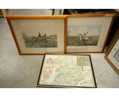
![John Speed , Map of Leicester, both Countye and Citie, 1610 [circa 1614], hand coloured, in a frame glazed front and back, 38](https://cdn.globalauctionplatform.com/95f38e6c-5371-4fa1-b664-a88600cdd476/faf160c1-aa1b-403a-f673-d956f99bd755/468x382.jpg)


Lot 91
Yorkshire Maps - 'Direct Roads' - New Malton to Scarborough, printed for Carington Bowles pub. 1785 and one other road map, 'The North Riding of Yorkshire', by Thomas Kitchin printed for R. Baldwin, for the London Magazine and one other max 15cm x 21cm (4) Condition Report Click here for further images, condition, auction times & delivery costs


Lot 584
Box of Various Vintage Folded Ordnance Survey Maps including Contoured Road Maps, 1920's edition of London, Quantity of 1903 Edition 1:2500 Scale, County of Surrey Map Live Stock Dept. Paddington, W H Smith's reduced Ordnance Survey Maps of Somerset and Hampshire, Stanford's Map of England & Wales showing Canals and Rivers


Lot 577
World War II Air Vice Marshal group of six, attributed to Air Vice Marshal Roy Faville CBE, to include 1939-45 Star, Africa, Italy, France & Germany, Defence and War medal, also together with various other medals and badges, a 1949 Territorial medal, various equipment for map reading and planning, his Rolleiflex camera, an oil painting of two 140 Wing de Havilland Mosquitos by Victor Kelly, 1944 Europe Air Map, a shoe horn with Third Reich insignia and FI U.V. 1938 to the underside found at Gutersloh, a silver plated presentation tray, (qty) Commands held No.42 Squadron, No. 140 Squadron, RAF Gutersloh, RAF St Eval, RAF Staff College Bracknell and No.22 Group. Provenance, by family descent


Lot 628
A signed copy of "Nymphs & The Trout" by Frank Sawyer, sold with 5 flies tied and personally autographed by Frank Sawyer December 1975, Sawyer pheasant tail, Sawyer grey goose, Sawyer bow tie buzzer, Sawyer Swedish and The Sawyer killer bug. this copy belonging to Captain Jack Shepherd and also with a map of The Services Dry Fly Fishing Association Water and a number of personal letters from Frank Sawyer to Jack Shepherd and from Tim Sawyer to Jack Shepherd along with a number of Christmas cards.

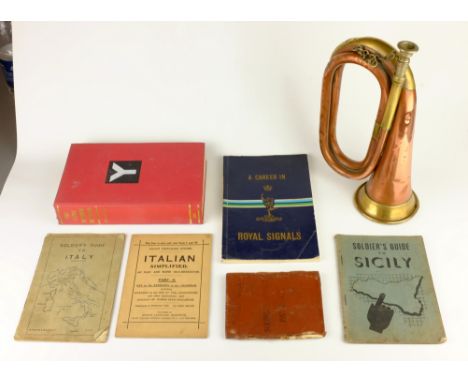
Lot 2135
Soldier's Pay Book for 536465 Thomas Reuben Mattocks, Soldier's Guide to Italy & Sicily, A Career in Royal Signals, The Fifth British Division 1939-45, a map of Catterick Camp, a cut-away plan of The Avro Lancaster and a copper & brass Bugle Condition Report Click here for further images, condition, auction times & delivery costs

Lot 2138
'Northern Ireland', map after Ernest Clegg engraved by John Waddington, Leeds 1947 pub. Countryman Ltd signed by Winston Churchill, Viscount Montgomery of Alamein, Sir Claude Auchinleck, Viscount Alanbrooke, Viscount Alexander, Basil McFarland, Donald McCullough, the artist and others 44cm x 56cm Condition Report Click here for further images, condition, auction times & delivery costs


Lot 134
ALEX. KEITH JOHNSTON - 'ATLAS TO ALISON'S HISTORY OF EUROPE', A New Edition, William Blackwood & Sons, 1850, over 100 hand coloured plans and maps of battles and sieges¦Condition Report:Leather spine has wear and scratching, stains on cloth cover, maps and plans very good, no linen backed folding map¦
-
109182 item(s)/page