We found 109198 price guide item(s) matching your search
There are 109198 lots that match your search criteria. Subscribe now to get instant access to the full price guide service.
Click here to subscribe- List
- Grid
-
109198 item(s)/page


Lot 61
BONVALOT (Gabriel): 'Across Thibet..', New York, Cassell Publishing Company, (1892): publishers blue pictorial cloth, recased with endpaper joints renewed, folding map contained in front pocket, a little rubbed, 8vo: with a copy of Savage-Landor's 'In the Forbidden Lane', Harper 1899, 2 vols in decorative publishers cloth, 8vo. (3)
Lot 63
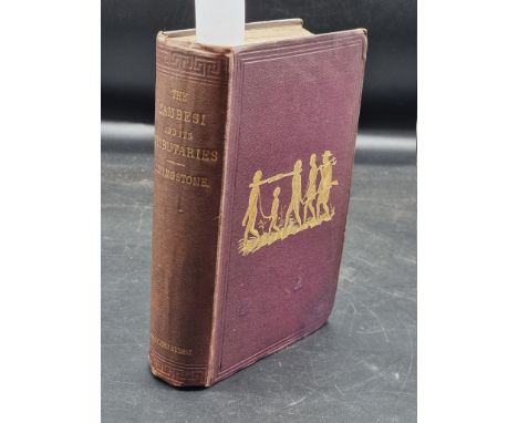
LIVINGSTONE (David & Charles): 'Narrative of an expedition to the Zambesi and its tributaries...' London, John Murray, 1865: FIRST EDITION. With folding frontis and folding map: publishers plum cloth, blind stamped and gilt lettered, a little bumped and stained to corners, light wear and sunning else a good copy. (1)
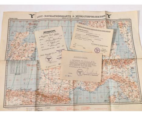
Lot 101
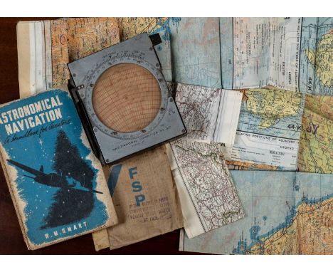
A group of mid 20th century silk maps: one showing Germany centred with Berlin; another with France, Portugal and the Mediterranean; three of the same maps of French Indo-China 'Sheet J'; a further similar map 'Sheet M'; an Air Ministry Navigational Computor MA.III; a Headquarters Home Command radio and procedure notes for RAF VR Signallers Parts 1 and 2; Radio Facility charts for October 1949; and two further RAF maps of EnglandIn used condition with minor marks, stains etc.


Lot 958
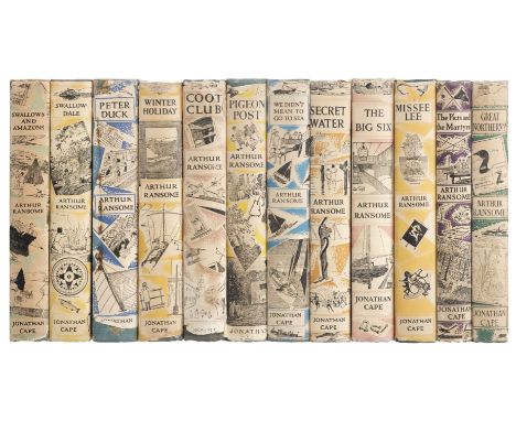
Ransome (Arthur). A set of all 12 'Swallows and Amazons' titles, 1955-1962, all later impressions, illustrations, map endpapers, original cloth, a few a little rubbed with some light fading, dust jackets, some price-clipped, slight toning to a few spines, a few spots and stains to one or two rear panels, a few small chips and tears, 8vo, together with others modern and related including Rod and Line, Flyfisher's Classic Library, 1993, limited edition of 600, Arthur Ransome and the World of the Swallows and Amazons, by Roger Wardale, 2000, A Ransome Bookcase, by John Cowen, 2000Ted Alexander & Tatiana Verizhnikova's Ransome in Russia, 2003, Jiobbooms and Bobstays, 2003 QTY: (approximately 55)


Lot 97
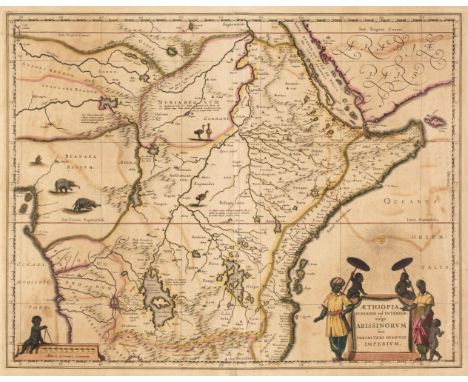
Africa. Blaeu (Willem Janszoon), Aethiopia Inferior vel Exterior..., circa 1645, engraved map of South Africa with contemporary outline colouring, large decorative cartouche, slight staining and creasing to the margins, but not affecting the printed image, 385 x 500 mm, French text on verso, together with Blaeu (Willem Janszoon). Aethiopia Superior vel Interior vulgo Abissinorum sive Presbiteri Joannis Imperium, Amsterdam, circa 1660, uncoloured engraved map, some staining and spotting, 390 x 500 mm, Latin text on versoQTY: (2)
Lot 971
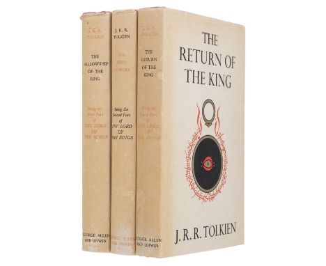
Tolkien (J.R.R). The Lord of the Rings: The Fellowship of the Ring, 14th impression, 1965; The Two Towers, 11th impression, 1965; The Return of the King, 11th impression, 1965; London: George Allen & Unwin, folding map to end of each volume, top edge red, bookseller's ticket to front pastedown lower margin, original red cloth gilt, dust jackets, spines toned, extremities lightly rubbed, 8voQTY: (3)
Lot 972
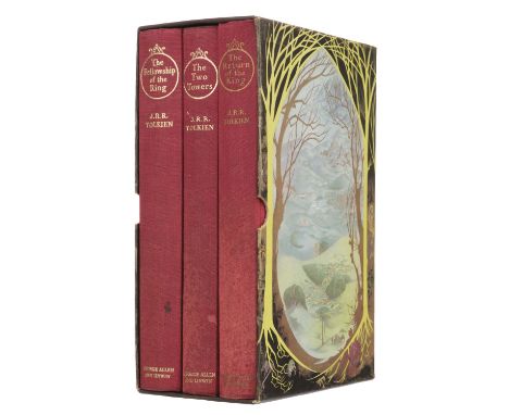
Tolkien (J.R.R.) Lord of the Rings: The Fellowship of the Ring, 13th impression, 1963; The Two Towers, 10th impression, 1963; The Return of the King, 10th impression, 1963, folding map at end of each, a few minor spots, original red cloth, some light fading and marks to spines, contained in a later slipcase, together with a small white card signed by the author loosely insertedQTY: (4)
Lot 973
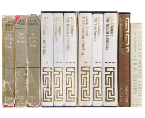
Tolkien (J.R.R.) The Lord of the Rings: The Fellowship of the Ring, 2nd edition, 5th impression, 1970; The Two Towers, 2nd edition, 5th impression, 1970; The Return of the King, 2nd edition, 6th impression, 1971, folding map at end of each, bookplate and previous owner signature to Two Towers, original cloth, Return with small insect predation at foot of spine, some light flecked stains to covers, dust jackets, some chips and tears, some adhesive tape repairs and edge wear, 8vo, together with The Lord of the Rings, 3 volumes, Folio Society, 1977 in slipcase (spine lettering to Fellowship partly rubbed away), another Folio Society set of the same, 2nd impression, 1979, The Hobbit, Folio Society, 1976, and Master of Middle-earth. the Achievement of J.R.R. Tolkien, by Paul H. Kocher, 1973QTY: (7)
Lot 974
Walpole (Hugh). Rogue Herries, 1st edition, London: Macmillan and Co., 1930, bookplate to front endpaper verso, map endpapers, top edge green, original cloth gilt, dust jacket, small chips at spine ends and folds, some light toning, 8vo, contemporary morocco-backed solander box, spine faded, 8vo, presentation copy, inscribed to half title "For Edward Knobloch affectionally from his friend Hugh Walpole, March 30" (Edward Knoblauch or Knoblock, 1874-1945, playwright), with a one-page autograph letter dated August 1925 to a Mr Warrimer enclosing a poem, loosely inserted, together with Maugham (William Somerset). The Vagrant Mood. Six Essays, London: William Heinemann, 1952, bookplate, top edge gilt, original contrasting morocco, slipcase, 8vo, limited signed edition 148/500, plus Young (Francis Brett). Black Roses, London: William Heinemann, 1929, light spotting to endpapers, bookplate, original vellum, some toning, 8vo, limited signed edition 500/525, with three others: Francis Brett Young's Jim Redlake, 1930, limited signed edition 18/275, Down in the Valley, by H.W. Freeman, 1930, limited signed edition 21/132, and Hiroshima, by John Hersey, 1st edition, New York, 1946 QTY: (6)

Lot 98
Africa. Sayer (Robert, publisher), Africa according to the Sieur D'Anville Illustrated with a Summary Description Relative to its Trade and Natural Produce, Manners and Customs of the Natives, European Settlements and other Useful Particulars, circa 1780, large map engraved by Richard Bennett with contemporary outline colouring on two sheets, uncoloured allegorical cartouche decorated with native figures, inset map of the Gold Coast, several inset blocks of descriptive text, old folds, some dust soiling, some marginal fraying, staining and marginal closed tears, some folds torn, frayed and stained with slight loss, some folds crudely repaired on verso and recto, each sheet approximately 520 x 1205 mmQTY: (2)

Lot 99
Africa. Six maps, 18th & 19th century, engraved maps, five of the continent with examples by or after Bell, Findlay, Baker, Rollos and Jeffries, various sizes, good condition, and one of the Cape of Good Hope by Findlay, all mounted, together with Prinald (Richard). A New Map of the World on Mercator's projection, circa 1780, hand-coloured engraved map 195 x 290 mm, mountedQTY: (7)
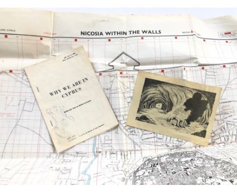
Lot 319
Cyprus Emergency 1957-58 British Army Maps etc. Comprising: Map June 1958 Nicosia Within the Walls Ink stamp Ops Room Headquarters 50 Indep Inf Brigade. Map June 1958 Nicosia. Double Sided Propaganda leaflet British Serviceman booklet May 1956 Why We Are In Cyprus. GC (4 items) PAYMENT BY BANK TRANSFER ONLY
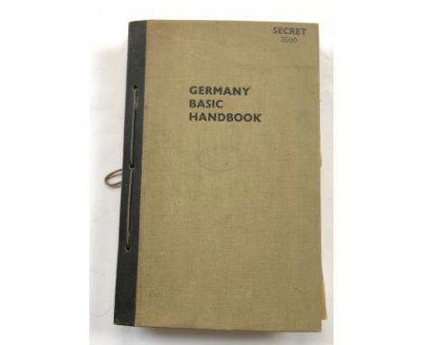
Lot 321
WW2 July 1944 Germany Basic Handbook. Official Secret/Restricted Publication. This restricted official publication is numbered 3,500. Split into section which deal with Geographical, Historical and Social, Map, Uniforms etc. Accompanied a 8 postcards and photographs, some of German military interest. PAYMENT BY BANK TRANSFER ONLY
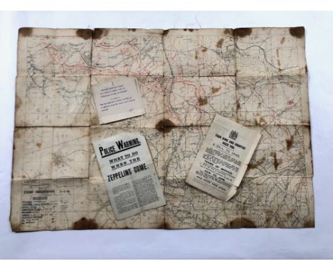
Lot 322
WW1 142nd Machine Gun Corps January 1918 Map. This linen backed map shows the enemy organisation as of the 3rd January 1918 and shows the area north of Hayrincourt. Has been used with service wear. The back with an ink stamp for the 142nd Machine Gun Company. Accompanied by a leaflet POLICE WARNING what To Do when the Zeppelins Come. Also Call to Arms leaflet. Some age wear (4 items) PAYMENT BY BANK TRANSFER ONLY
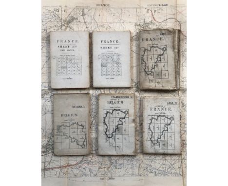
Lot 323
WW1 British August 1918 Trench Map plus others. A good clean example of War Department Map Sheet 57c NE showing enemy organisation as of the 20th August 1918. Clean condition. Accompanied by a further four 1/100,000 scale maps of France and Belgium and a similar two maps of France 1/40,000 Overall clean, some use. (7 maps) PAYMENT BY BANK TRANSFER ONLY

Lot 1
A & C Black. Younghusband (Francis, E. Molyneux). Kashmir, London: Adam and Charles Black, 1909, colour frontispiece, colour illustrations throughout, folding map & advertisements to rear, lightly spotted (heavier to preliminaries), contemporary gift inscription to front blank, rear hinge cracked, original red pictorial cloth gilt, top edge gilt, rubbed, 8vo, together with:Ryan (Frederick W, Vittorio Boron). Malta, London: Adam & Charles Black, 1910, colour frontispiece, colour illustrations throughout, folding map & advertisements to rear, ownership inscription to front blank, original green pictorial cloth gilt, top edge gilt, rubbed, 8vo, withWigram (Edgar T.A). Northern Spain, London: Adam & Charles Black, 1906, colour frontispiece, colour illustrations throughout, folding map & advertisements to rear, original orange pictorial cloth gilt, top edge gilt, lightly rubbed, 8vo, with 10 others published by A & C BlackQTY: (13)

Lot 100
* Americas. Bertius (Petrus), Carte de l'Amerique Corrigée, et augmentée dessus toutes les aultres cy devant: faites P. Bertius, 1639, hand coloured engraved map, strapwork cartouche and 2 inset maps of the polar regions, 380 x 495 mm, mounted, framed and glazedQTY: (1)NOTE:Philip D.Burden, The Mapping of North America, 256, state 1. A separately published map of America, based upon Jodocus Hondius's earlier map of 1618, but a reduced version of the Bertius/Tavernier map of 1627.

Lot 102
* Asia. Blaeu (Willem Janszoon), Asia noviter delineata, Amsterdam, circa 1633, hand-coloured engraved map, vertical margins trimmed with slight loss, slight creasing, laid on later card, 360 x 460 mm, framed and glazedQTY: (1)NOTE:A variant edition, published without the decorative panels in Van Meteren's 'Meteraunus Novus'.
Lot 103
Asia. Hondius (Henricus), Asia Recens Summa Cura Delineata, Jan Jansson, Amsterdam, circa 1641, uncoloured engraved map, ornamental strapwork title cartouche flanked by costumed figures, separate dedication cartouche, several sailing ships, sea monsters and indigenous animals, 375 x 500 mm, no text on verso, together with Ortelius (Abraham). Asiae Nova Descriptio [1575 or later], engraved map with contemporary wash colouring, slight fraying to the central fold, trimmed to the neatline and laid on later stiff paper, 370 x 480 mm, an allegorical engraving of a young woman representing Asia (L'Asie) by Rousselet on verso QTY: (2)NOTE:The first described map was originally one of the celebrated Hondius 'carte-a-figures' maps, featuring border vignettes of principal Asian cities and figures in various types of national dress. Because most of these maps were too large to fit into later atlas printings by Hondius and Jansson, the decorative borders were often removed or blocked out, which is why the border measurements on this example only feature on three of the four sides.

Lot 104
Asia. Speed (John), Asia with the Ilands adjoyning described, the atire of the people & townes of importance, all of them newly augmented by J. S., Ano Dom: 1626, Thomas Bassett & Richard Chiswell [1676], hand coloured engraved 'carte-a-figures' map with ten costumed figures to the vertical margins and eight oval vignettes of principal cities along the upper margin, some water staining and dust soiling, repaired marginal closed tears, narrow margins, central fold strengthened and repaired on verso, 400 x 510 mm, English text on versoQTY: (1)

Lot 105
Australia. Arrowsmith (J.), Part of the North Coast of Australia shewing the situation of Port Essington. Compiled from Official Documents, James & Luke Hansard, 1843, lithographic map with contemporary outline colouring, inset maps of the Western Hemisphere, Plan of Port Essington and India and the East Indies, some offsetting, old folds, 525 x 605 mmQTY: (1)NOTE:Port Essington was colonized in 1838. With its geographical position on the north coast of Australia, it was hoped that it would prove a strategic port for trade with Asia and the East Indies. It failed and was abandoned in 1849.
Lot 107
* Blaeu (Willem Janszoon). Aethiopia Superior vel Interior vulgo Abissinorum sive Presbiteri Joannis Imperium, Amsterdam, circa 1660, engraved map with contemporary outline colouring, some staining and offsetting, decorative cartouche and mileage scale, 385 x 490 mm, mounted, framed and glazed, together with Blaeu (Johannes). Taurica Chersonesus Nostra aetate Przecopsca et Gazara dicitur, Amsterdam circa 1650, engraved map of Ukraine with contemporary outline colouring, slight spotting, faint toning to the central fold, 380 x 500 mm, mounted, framed and glazed, with Dapper (Olivier). Barbaria Biledulgerid o Libye et pars Nigritarum Terra, circa 1680, hand-coloured engraved map of North Africa, decorative cartouche, 270 x 330 mm, framed and glazed, plus Sanson (Nicolas). Estats de la Couronne de Pologne..., circa 1700, hand-coloured engraved map, strapwork cartouche, old folds, 190 x 255 mm, mounted, framed and glazedQTY: (4)
![Bohemia. Speed (John), Bohemia Newly Described, Thomas Bassett & Richard Chiswell [1676], uncoloured engraved 'carte-a fi](https://cdn.globalauctionplatform.com/f2d55b0d-bea0-4ba1-96c5-af5f00b8a264/55b15c00-eec5-4215-b5fa-af5f011dafd1/468x382.jpg)
Lot 108
Bohemia. Speed (John), Bohemia Newly Described, Thomas Bassett & Richard Chiswell [1676], uncoloured engraved 'carte-a figure' map, ten costume vignettes to vertical margins and seven oval vignettes of principal cities to upper horizontal margin, three margins strengthened on the verso, lower margin crudely repaired, some short closed tears, some staining, 415 x 525 mm, English text on verso, together with Jansson (Jan), Oxonium Comitatus vulgo Oxfordshire [and] Comitatus Cantabrigiensis vernacule Cambridgeshire, Amsterdam, circa 1650, two engraved maps with contemporary outline colouring, some oxidization to the old watercolour causing cracking and splitting to the paper, some staining, each approximately 420 x 520 mm, Latin text on verso, with Valk (Gerard & Schenk P.). Ducatus Eboracensis Anglice Yorkshire, Amsterdam, circa 1700, engraved reticulated map with bright contemporary wash colouring, some oxidization to the old watercolour causing cracking and splitting to the paper, slight spotting and staining, 380 x 480 mm, plus Blaeu (Johannes). Comitatus Northumbria vernacule Northumberland, Amsterdam, circa 1645, engraved map with contemporary outline colouring, heightened in gold, paper 'soft' and weak causing cracking and splitting to the printed image, crudely repaired on verso, 410 x 500 mm, French text on versoQTY: (5)NOTE:Sold not subject to return.
Lot 11
Bougainville (Louis Antoine de). A Voyage Round the World, performed by order of his most Christian Majesty, in the years 1766, 1767, 1768, and 1769, Dublin: J. Exshaw, 1772, engraved large folding map, engraved folding plate, occasional light spotting, front free endpaper lacking, front hinge tender, contemporary calf gilt, red morocco title label, base of front joint cracked, rubbed, 8voQTY: (1)NOTE:Sabin 6869. Printed in the same year as the first London edition.
![British Isles. Bordone (Benedetto), Inghilterra secondo Tolemeo [printed on map], Venice [1528 -34], uncoloured woodblock map](https://cdn.globalauctionplatform.com/f2d55b0d-bea0-4ba1-96c5-af5f00b8a264/ffb81f9e-6c8a-4b83-896f-af5f011db25d/468x382.jpg)
Lot 111
British Isles. Bordone (Benedetto), Inghilterra secondo Tolemeo [printed on map], Venice [1528 -34], uncoloured woodblock map in the Ptolemaic manner, with a map of England and Wales and Italian text on the verso, some marginal staining, 235 x 155 mm, together with Munster (Sebastian), Das Ander Buch von den Britannichen Insulm [circa 1628], uncoloured woodcut map with German text above and on verso of map, map size 255 x 170 mm, with Du Pinet (Antoine & Munster Sebastian). Des Isles d'Angleterre & d'Ecosse & de celle de Irlandt, Lyons [1564], uncoloured woodblock map with French text below and on the verso of the maps, map size 90 x 150 mm, with another copy similar, plus Gastaldi (Giacomo). Angliae E Hibernia Nova, Venice [1548], uncoloured engraved map, 135 x 175 mm, Italian text on versoQTY: (5)NOTE:R. W. Shirley. Early Printed Maps of the British Isles, 1477 - 1650, numbers 22, 122, 76a and 48 respectively.
Lot 112
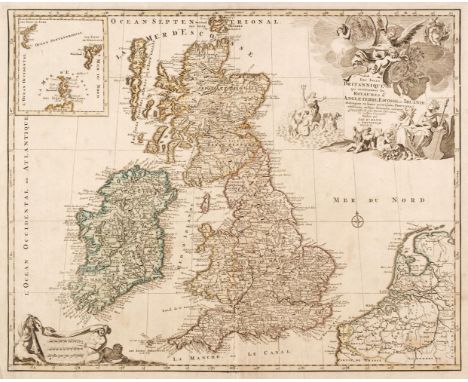
British Isles. Elwe (Ian), Les Isles Britannique qui contiennent les Royaumes d'Angleterre, Ecosse et Irlande..., Amsterdam, 1792, engraved map with contemporary hand colouring, inset map of the Shetland and Orkney Islands, slight overall dust soiling, central fold repaired on verso, occasional marginal closed tears, professionally repaired on verso, 475 x 595 mm, together with De Lisle (Guillaume). Les Isles Britanniques ou sont le Royaumes d'Angleterre, tiré de Sped celuy d'Ecosse tiré de Th. Pont et celuy d'Irlande tiré de Petti..., J. Covens & C. Mortier, Amsterdam, circa 1760, engraved map with sparse contemporary outline colouring, large decorative cartouche and mileage scale, central fold partially strengthened on verso, 480 x 580 mm, with De Wit (Frederick). Accuratissima Angliae Regni et Walliae Principatus..., Amsterdam, circa 1690, uncoloured engraved map, large decorative cartouche, slight creasing and staining, 580 x 490 mmQTY: (3)
![British Isles. Hondius (H. Mercator Gerard & Purchas Samuel), Anglia, Scotia et Hibernia [and] Anglia [1625], two hand-co](https://cdn.globalauctionplatform.com/f2d55b0d-bea0-4ba1-96c5-af5f00b8a264/a77083d4-ba41-472b-9a18-af5f011db3ee/468x382.jpg)
Lot 113
British Isles. Hondius (H. Mercator Gerard & Purchas Samuel), Anglia, Scotia et Hibernia [and] Anglia [1625], two hand-coloured engraved maps, each approximately 135 x 180 (map size), with English text above, below and on verso of map, together with Humble (George, publisher). The Kingdome of England [1627], uncoloured engraved map, 85 x 125 mm, English text on verso, with Duval (Pierre). Isles Britanniques [and] Angleterre, circa 1660 &1670, two uncoloured engraved maps, some toning, marginal holes and crayon marginalia to the map of the British Isles, each approximately 100 x 125 mm, with another coloured copy of 'Angleterre', plus Bertius (Petrus). Magna Britannia [1616], hand-coloured engraved map, orientated to the east, 105 x 140 mm, Latin text on verso, and Bertius (Petrus). Anglia, heirs of Willem Janszoon Blaeu, Amsterdam [1639], uncoloured engraved map, published in a late and reduced version of William Camden's 'Britannia', old folds, 100 x 135 mm, no text on verso, with two other miniature maps of the British Isles by Cluver and DesingQTY: (10)NOTE:R. W. Shirley. Early Printed Maps of the British Isles 1477 - 1650, numbers 391, 392 & 395. R. W. Shirley. Printed Maps of the British Isles, Duval 1. (the second described map is not listed) and Duval 1 (described only), R. W. Shirley. Early Printed Maps of the British Isles 1477 - 1650, numbers 348 & 492.
![British Isles. Honter (Johannes), Atlantici Maris ora et Insulae, Basle [1576], uncoloured Ptolemaic map on a trapezoidal pro](https://cdn.globalauctionplatform.com/f2d55b0d-bea0-4ba1-96c5-af5f00b8a264/bc549d63-a358-45d9-8013-af5f011db4d1/468x382.jpg)
Lot 114
British Isles. Honter (Johannes), Atlantici Maris ora et Insulae, Basle [1576], uncoloured Ptolemaic map on a trapezoidal projection, initially published in Pomponius Mela's ' Pomponii Melae De orbis situ libri...,' 130 x 160 mm, together with Bill (John). A Tipe of England [1626], uncoloured engraved map, 100 x 135 mm, English text on verso, with Heyns (Zacharias). Anglia, Scotia et Hibernia, Amsterdam [1598], woodcut map with contemporary hand colouring, orientated to the west, slight staining, title trimmed with slight loss, 145 x 180 mm, French text on verso, plus Vrients (J. B. & Ortelius Abraham). Angliae Regnum [1609], hand-coloured engraved map originally published in the 'Epitome Theatro Orbis Terrarum...', 85 x 125 mm, Latin text on verso, and Bertius (Petrus). Anglia, Scotia et Hibernia [and] Anglia [1616], two uncoloured engraved maps, each slightly toned, each approximately 100 x 135 mm, Latin text on versoQTY: (6)NOTE:R. W. Shirley. Early Printed Maps of the British Isles 1477 - 1650, numbers 115b, 393, 202, 305, 347 & 349 respectively.
Lot 115
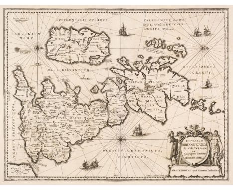
British Isles. Jansson (Jan & Ortelius Abraham), Insularum Britannicarum Acurata Delineatio ex Geographicis Conatibus Abrahami Ortelii, Amsterdam, 1646 [or later], an uncoloured historical map engraved by Pieter van den Keere, large decorative cartouche, compass rose and numerous rhumb lines, orientated to the west, several repaired marginal closed tears, the whole backed with archival tissue, 395 x 510 mm, French text on verso, together with another copy similar, plus Mercator (Gerard). Tab. I. Europae Continens Albion Britanniam et Hiberniam, circa 1690, uncoloured engraved Ptolemaic map of the British Isles with Scotland orientated to the east, slight marginal staining, one vertical crease, 340 x 410 mm, with Pigot (James). Pigot & Co.'s New Map of England & Wales with part of Scotland..., circa 1840, engraved map with contemporary outline colouring, some offsetting, old folds, 705 x 535 mm, QTY: (4)
![* British Isles. Ortelius (Abraham), Britannicarum Insularum Typus, [1595 or later], engraved map with contemporary outline c](https://cdn.globalauctionplatform.com/f2d55b0d-bea0-4ba1-96c5-af5f00b8a264/d7945855-1865-4a45-84ba-af5f011db674/468x382.jpg)
Lot 116
* British Isles. Ortelius (Abraham), Britannicarum Insularum Typus, [1595 or later], engraved map with contemporary outline colouring, orientated to the west, large strapwork cartouche, slight mount staining and overall toning, some oxidization to the old watercolour with occasional cracking to the image (there is a note on the verso of the frame stating that the map has been stabilised with Japanese tissue), some repairs to the margins, but not affecting the printed image, 365 x 505 mm, framed and glazedQTY: (1)NOTE:Marcel van den Broecke. Ortelius Atlas Maps number 192. Originally published in the Parergon.

Lot 117
British Isles. Pine (John), A Chart shewing the several Places of Action between the English and Spanish Fleets, with the Places where several of the Spanish Ships were destroyed in their return to Spain, North about the British Islands, June 24th 1739, uncoloured engraved map with a highly decorative pictorial & allegorical border, some creasing and staining, trimmed to the neatline with some marginal fraying, occasional marginal closed tears, laid on later paper, 375 x 600 mmQTY: (1)
![British Isles. Quad (Matthias), Angliae regni florentisimi nova descriptio auctore Humeredo Lhuyd Denbygiense, [1600], uncolo](https://cdn.globalauctionplatform.com/f2d55b0d-bea0-4ba1-96c5-af5f00b8a264/34852983-9588-4118-b808-af5f011db81f/468x382.jpg)
Lot 118
British Isles. Quad (Matthias), Angliae regni florentisimi nova descriptio auctore Humeredo Lhuyd Denbygiense, [1600], uncoloured engraved map, slight dust soiling and text show through, 185 x 270 mm, German text on verso, together with Rogers (William). Britannia Provincia Romanorum [1600], uncoloured engraved map, slight staining to the margins, 170 x 210 mm, with Cloppenburg (Jan & Van den Keere Pieter). Anglia Scotia et Hibernia, Amsterdam [1630], uncoloured engraved map, 195 x 260 mm, French text on verso, plus Botero (Giovanni). Anglia Scotia et Hibernia, Ursel [1602], uncoloured engraved map, slight text show through, 195 x 215 mm, German text on verso and Clüver (Philip). Veteris et Nova Britanniae Descriptio [1711], uncoloured engraved map, old folds, 215 x 265 mmQTY: (5)
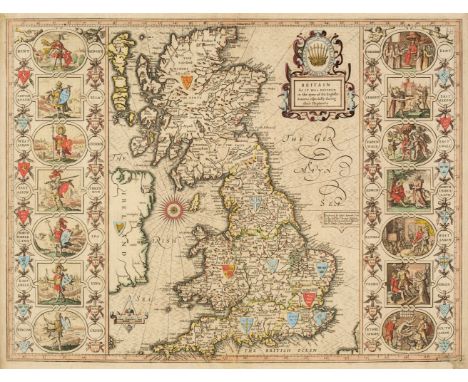
Lot 119
* British Isles. Speed (John), Britain as it was devided in the tyme of the English Saxons especially during their Heptarchy, Thomas Bassett & Richard Chiswell [1676], hand coloured engraved map, large strapwork cartouche, compass rose and numerous rhumb lines, the vertical borders decorated with historical scenes, slight creasing, occasional worm holes affecting the printed surface, 385 x 510 mm, framed and double-glazed, English text on versoQTY: (1)

Lot 12
Burton (Richard F). The Lake Regions of Central Africa, a picture of exploration, 1st edition, 2 volumes, London: Longman, Green, Longman, and Roberts, 1860, half-titles, 12 chromoxylograph plates, wood-engraved illustrations to text, folding map to rear of volume 2, 'East African Ghouts' plate trimmed to margins (not affecting text), a few gatherings to volume 1 with small tear to upper margin, map with adhesive tape repair to one fold, lightly toned, endpapers renewed, modern red half morocco gilt, 8voQTY: (2)NOTE:Penzer pp.65-66.Burton's quest for the source of the Nile. A landmark in 19th-century East African exploration, it is also regarded as Burton's best travel writing. Accompanied by John Hanning Speke, this expedition was the source of the pair's feud. Speke found the southern shore of Lake Victoria, claiming it to be the source of the Nile. Upon return to England, Burton famously attacked both this hypothesis and Speke himself.
![* Buckinghamshire. Speed (John), Buckingham both Shyre and Shire towne describ. George Humble [1616], hand-coloured engraved](https://cdn.globalauctionplatform.com/f2d55b0d-bea0-4ba1-96c5-af5f00b8a264/7c8d79b4-f2c6-4fb5-b2df-af5f011db9be/468x382.jpg)

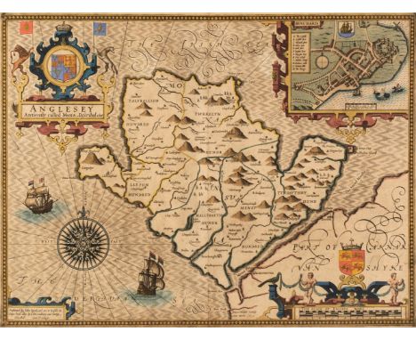
Lot 121
Caernarvonshire. Speed (John), Caernarvon Both Shyre and Shire-towne with the ancient Citie Bangor Described, Thomas Bassett & Richard Chiswell [1676], hand coloured engraved map, inset town plans of Caernarvon and Bangor, 385 x 510 mm, English text on verso, together with Caermarden both Shyre and Towne Described, Thomas Bassett & Richard Chiswell [1676], hand coloured engraved map, inset town plan of Caermarden, slight creasing, 385 x 505 mm, English text on versoQTY: (2)
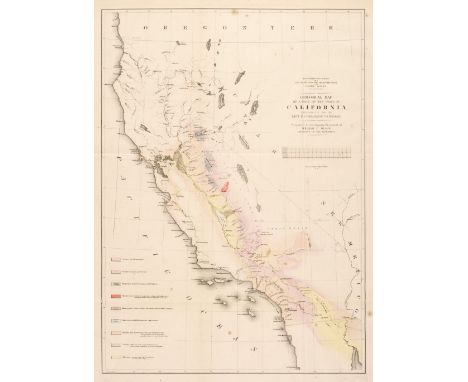
Lot 122
California. Geological Map of a Part of the State of California, Explored in 1855 by Lieut R. S. Williamson. U. S. Top. Engr. Prepared to accompany the report of William P. Blake Geologist of the Expedition, Sarony, Major & Knapp, New York, 1855, lithographic map and key plate with contemporary outline colouring, old folds, slight creasing and spotting, 565 x 410 mmQTY: (1)

Lot 123
* Cambridgeshire. Speed (John), Cambridgeshire described with the Devision of the Hundreds, the Townes situation with the Armes of the Colleges of that famous Universiti and also the Armes of all such Princes and Noble men as have heertofore borne the Honorable Tytles & Dignities of the Earldome of Cambridge, Roger Rea 1662, hand coloured engraved map, inset town plan of Cambridge, 24 heraldic shields to the margins, slight creasing to the central fold, 385 x 520 mm, mounted, framed and glazedQTY: (1)

Lot 127
China. Jih - Sin Geographical Institute (publisher), New China Map, 1938, colour printed lithographic map laid on linen, old folds, some creasing and dust soiling, old ink library stamps to the margins, 720 x 1040 mm, together with Hong Kong and New Territories, Fourteen charts, Geographical Section, General Staff, The War Office, 1932 - 52, 14 colour printed charts, old folds, some marginal fraying and closed tears, occasional duplicates, slight dust soiling and creasing but largely confined to the margins, each approximately 660 x 900 mmQTY: (15)NOTE:The Hong Kong and New Territories charts cover the following areas. Victoria Harbour, Sai Heung (2), Wan Ha, Tung Kwu (2), Sha Tau, Sha Tau Kok, Tathong Channel, Cheung Chau Island, San Tin (2), Repulse Bay, Tsing Wu [and] Wong Tin.
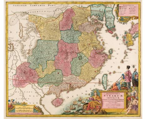
Lot 128
China. Lotter (Tobias Conrad), Opulentissimum Sinarum Imperium juxta Recentissimam Delineationem in suas Provincias Disterminatum Cura et Sumtibus, Augsburg, circa 1760, engraved map with contemporary hand-colouring and some later enhancement, large allegorical cartouche, very slight staining to margins, 500 x 580 mQTY: (1)NOTE:The map shows China divided into provinces, with an allegorical title cartouche representing European trade with China. It was originally published around 1730 by Matthaus Seutter, but this example was published some thirty years later by Seutter's son-in-law & successor, Tobias Lotter
![China. Speed (John), The Kingdome of China, George Humble, [1627], hand-coloured 'carte-a-figure' map, with eight costumed fi](https://cdn.globalauctionplatform.com/f2d55b0d-bea0-4ba1-96c5-af5f00b8a264/94684579-05f3-4c78-89ab-af5f011dc319/468x382.jpg)
Lot 129
China. Speed (John), The Kingdome of China, George Humble, [1627], hand-coloured 'carte-a-figure' map, with eight costumed figures to the vertical margins and four oval vignettes of principal cities to the upper margin, 395 x 510 mm, English text on versoQTY: (1)NOTE:A fine and detailed map of China, based on the earlier Ortelius map of 1584. There are four oval vignettes along the upper margin which depict the cities of Macao and Quinzay as well as a manner of execution and a method of travelling which depicts a land yacht. The northeast of the country is shown as full of devils and fantastic animals. Korea is erroneously mapped as an island and the Bering Straits are described as 'The Straite of Anian'.
Lot 13
Burton (Richard F). The Land of Midian (Revisited), 1st edition, 2 volumes, London: C. Kegan Paul & Co, 1879, folding map to rear of volume 2, 16 plates (6 colour lithographs), uncut, small library blindstamp to volume 1 front free endpaper, lightly dust-soiled, original red cloth gilt, spines toned, rubbed, 8vo, together with:Bent (Theodore). Southern Arabia, 1st edition, London: Smith, Elder, & Co, 1900, portrait frontispiece, 6 folding maps, black and white plates, lightly dust-soiled, hinges cracked, original red cloth gilt, rubbed, 8vo, withLees (G. Robinson). Life and Adventure Beyond Jordan, London: Charles H. Kelly, [1910], colour frontispiece, black and white illustrations (many full-page), endpapers toned, original blue pictorial cloth gilt, spine faded, rubbed, 8vo, with 4 others on the Middle-EastQTY: (8)

![* Cornwall. Speed (John & Norden John), Cornwall, Thomas Bassett & Richard Chiswell [1676], uncoloured engraved map,](https://cdn.globalauctionplatform.com/f2d55b0d-bea0-4ba1-96c5-af5f00b8a264/82db9b1f-15e2-4f10-a51f-af5f011dc4b8/468x382.jpg)
Lot 131
* Cornwall. Speed (John & Norden John), Cornwall, Thomas Bassett & Richard Chiswell [1676], uncoloured engraved map, inset view of Launceston, large strapwork cartouche and compass rose, very slight staining and dust soiling, some toning to the central fold, 385 x 510 mm, framed and double-glazed, English text on versoQTY: (1)
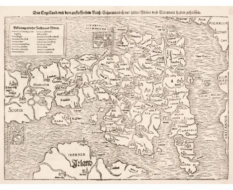
Lot 135
England & Wales. Munster (Sebastian), Das Engelland mit dem Anstossenden Reich Schottland so vor zeiten Albion und Britannia haben geheissen, Basle [1578], uncoloured woodblock map orientated to the east, central fold repaired on verso, slight staining to the margins, additional title on verso which is contained within an elaborate woodcut showing costumed figures apparently dining on human flesh, 260 x 345 mmQTY: (1)NOTE:R. W. Shirley. Early Printed Maps of the British Isles 1477 - 1650, no. 120.

Lot 136
England & Wales. Murchison (Sir Roderick), Geological Map of England and Wales, 5th edition, Edward Stanford, 1864, map with bright contemporary hand colouring, engraved by J & C Walker, sectionalised and laid on linen, 405 x 330 mm, bound in the publisher's green cloth with gilt title to the upper sidingQTY: (1)
-
109198 item(s)/page