

Air Navigation Map No. 23 (Experimental) Saint Louis to Kansas City, MO. In 1921, the United States Army Air Corps initiated a compressive evaluation of aeronautical charts in an effort to develop a standardized map for aerial navigation. Based upon this study, the Air Corps issued 63 air navigation maps covering most of the military routes in the United States. Prior to 1926, these maps were jointly compiled by the Geological Survey and U. S. Army Engineer Reproduction Plant. By 1926, the preparation of air maps shifted to the U.S. Coast and Geodetic Survey (under the Commerce Department) with the passage of the Air Commerce Act. Maps from this point on were intended to merge the growing commercial airways system with the military network. This map covers the area from St. Louis west to Kansas City and shows elevation and contours, cities and towns, rivers, roads and railroads. Airfield classifications are shown with different symbols. True north and magnetic north are depicted. On a scale of 8 miles per inch. A colorful example with light toning mostly in the blank margins. Backed in linen. Ex-library stamp on verso. 38.4"" W x 10.3"" H U.S. Corps of Engineers, 1923
We found 108737 price guide item(s) matching your search
There are 108737 lots that match your search criteria. Subscribe now to get instant access to the full price guide service.
Click here to subscribe- List
- Grid
-
108737 item(s)/page

Montana Territory This is the uncommon large edition map that shows in great detail the extent of public surveys in Montana just two years before attaining statehood in 1889. Hydrology and topography are well developed on this colorful map. The map shows Indian reservations (Blackfeet, Flathead etc.), military posts (Forts - Assiniboine, Keogh, Maginnis, Custer, Camp Baker, etc.) and the completed and proposed railroads. Also locates Custer Hill, Custer`s Monument, and the Reno battlefield; and Yellowstone National Park in its entirety with major features identified. Remarkable detail throughout on a scale of 1 inch to 15 miles. Extensive legend identifies land offices, Surveyor Generals Office, county seats, towns, villages and railroad stations, railroads (completed and proposed), military reservations, Indian reservations, railroad land grant limits, etc. A colorful example issued folding with light color offsetting and several splits along the folds at bottom mostly closed on verso with archival tape. 26"" W x 39"" H General Land Office, 1887

Rand, McNally & Co.`s Montana This attractive folding map of Montana was issued 13 years after statehood. Through the use of red overprinting, the map depicts the numerous railroad lines operating throughout the state including the Burlington & Missouri River Railroad, Great Falls & Canada, Northern Pacific, and Oregon Short Line to name a few. Topography is well developed and numerous Indian Reservations are named. Drawn on a scale of 30 miles per inch and includes a 24-page index of place names. Folds into brown paper wrappers entitled ""Rand, McNally & Co.`s Indexed County and Township Pocket Map and Shippers` Guide of Montana."" The map, issued folding, is near mint and still attached to the back paper wrapper. Front wrapper and index are separated. 12.6"" W x 19"" H Rand McNally & Co., 1902

Railroad Commission Map of Montana This scarce, large detailed map of Montana displays all the current and proposed railroad lines in the state through the use of bold color overprinting. The map extends to include portions of Idaho and Wyoming (including Yellowstone) and depicts the lines of the Northern Pacific Railway, Great Northern Railway and the Chicago, Milwaukee & St. Paul Railway to name a few. Counties are displayed in full color and towns, villages, Indian Reservations and National Forests are located. Across the lower portion of the map is a large town and county index keyed to the map. The map was engraved and published by Rand McNally for the Montana Railroad Commission. Dissected and backed with linen and folds into maroon cloth covered boards measuring 6.0 x 8.5"". The map is clean with bright color and flawless. The cloth covers show only minor wear. 32.3"" W x 51.4"" H Rand McNally & Co., 1917
![[Lot of 2] The Falls and Portage [and] Principal Cascade of the Missouri This very uncommon map and plate are from the 1817](http://lot-images.atgmedia.com/SR/36385/2916721/259-2014116143816_468x382.jpg)
[Lot of 2] The Falls and Portage [and] Principal Cascade of the Missouri This very uncommon map and plate are from the 1817 Dublin edition of Paul Allen`s History of the Expedition Under the Command of Captains Lewis and Clarke, to the Sources of the Missouri.... The map focuses on the stretch of Missouri River around Great Falls. It depicts good detail of the portage route around the falls and contains numerous notations about the river. The plate is one of the earliest to depict the falls. A. The Falls and Portage (4.1 x 7.1""). Condition: One faint spot in the image and an edge tear confined to the right blank margin closed on verso with archival material. (B+)B. Principal Cascade of the Missouri (6.9 x 4.2""). Condition: A fine impression with minor soiling confined to the blank margins. (A) See description See description Lewis & Clark, 1817
![Map of the Territory of New Mexico, made by order of Brig. Gen. S. W. Kearney
[with] Report of Lieut. J. W. Abert, of his E](http://lot-images.atgmedia.com/SR/36385/2916721/261-2014116143820_468x382.jpg)
Map of the Territory of New Mexico, made by order of Brig. Gen. S. W. Kearney [with] Report of Lieut. J. W. Abert, of his Examination of New Mexico, in the Years 1846-47 During the War with Mexico, Lieutenants Abert and Peck were enroute to the Pacific with Lieut. Emory as part of General Kearny`s Army of the West, but the two were left behind due to illness. They took the opportunity to continue their survey efforts earlier started on Fremont`s third expedition. The resulting map is a very detailed look at the Rio Grande Valley and some adjacent areas including the pueblos of Laguna and Acoma. This important map, illustrated in Wheat, is roughly centered on Santa Fe. It details the territory along the Rio Grande from above Taos south to well below Socorro and San Antonio to the ruins at Valverde. Excellent detail of the topography and watershed to either side of the river with the mountains shown via hachure. Filled with place names including numerous villages and small towns, and the Comanche Route from Arkansas. Blank areas to the west and north are labeled Navajo Indians and Utah Indians. This map was issued with Emory`s Notes of a Military Reconnaissance in 1848. 10,000 copies were produced for this House of Representatives edition. This lot includes the unbound Abert`s report. Unbound, title page, pages 417 - 614, 24 plates, 7.3 X 4.3"" The plates include: Santa Fe; O-CUM-WHO-WUST; Old Bark`s Son AH-MAH-NAH-CO and Squaw; Las Cumbres Espanolas; San Miguel; Ruins of Pecos; The Gold Mountains near Tuerto; Fort Marcy and the Parraquia - Santa Fe; San Felippe; Pueblo de Santo Domingo; Pueblo de Santa Ana; Moquino; Acoma, No. 1; Acoma, No. 2; Acoma, No. 3; View near Rito; El Canon Inferno; Ruins of Abo; Bosque de Apache; Valverde, and four more. Historical and important map complete with its report. The map is very good with light toning along a few folds, one tiny split at a fold intersection, and an archivally repaired tear that enters 3"" into map at top left. Disbound text and plates have occasional light scattered foxing, otherwise clean and bright. 25"" W x 19.5"" H Abert & Peck, 1846-47
![[Lot of 2] Territory of New Mexico Compiled from the Official Records of the General Land Office and Other Sources... [and]](http://lot-images.atgmedia.com/SR/36385/2916721/262-2014116143822_468x382.jpg)
[Lot of 2] Territory of New Mexico Compiled from the Official Records of the General Land Office and Other Sources... [and] Map of the Territory of New Mexico A. Territory of New Mexico Compiled from the Official Records of the General Land Office and Other Sources..., dated 1903 (18.1 x 21.8""). A colorful and fascinating map published only nine years before New Mexico obtained statehood. Shows in incredible detail the extent of existing Indian Reservations, Military Reservations, Forest Reserves and Private Land Grants through color and pattern. The brown hachure indicating the mountains plus all the other colors used on the map combine to provide great visual impact. Filled with information on watershed, mountains, railroads, wagon roads, unsurveyed townships, etc. Locates the short-lived county of Leonard Wood to the southeast of Santa Fe with Santa Rosa as the county seat. In 1903 Guadalupe County was renamed Leonard Wood and then back to Guadalupe in 1905. The map was compiled by Frank Bond, Chief of Drafting Division and lithographed by the Andrew B. Graham Photo-Litho company. B. Map of the Territory of New Mexico, circa 1897 (13.0 x 18.8""). This detailed map identifies 80 mining districts which are listed in a table along the right margin. A note in the lower margin states ""Red lines on map indicate springs, running water, and irrigating ditches."" Issued folding with a hint of toning along a few folds. See description General Land Office, 1897-1903

Map of the Progress of His Majesty`s Armies in New York, During the Late Campaign Illustrating the Accounts Publish`d in the London Gazette This is the December 1776 issue of this map that adds additional battle information; the earlier edition (with a different title) was published in the October 1776 issue (see Jolly #GENT-248). Troop and battle deployments are clearly shown, including the recent actions around White Plains. It also shows additional towns and roads on Staten Island and in East Jersey. A fascinating Revolutionary War map designed to illustrate to the British people the progress of the war against the rebels. Issued folding, now flattened, with very minor offsetting. Remargined at left, top and right with a portion of neatline replaced in facsimile at left. 7.8"" W x 12.3"" H Anon., 1776

A Map of the Country in Which the Army under Lt. General Burgoyne Acted in the Campaign of 1777, Shewing the Marches of the Army & the Places of the Principal Actions This detailed and important map covers the area from the Chambly River (Richelieu River) south through Lake Champlain to Albany on the Hudson River. With the use of red hand coloring, the route of Burgoyne`s ill fated campaign to split the northeast colonies from the southern colonies is depicted. Although Burgoyne achieved early victories at Ticonderoga and Huberton, the difficulties of fielding such a large force in what was essentially a wilderness region against an enemy that displayed unconventional tactics turned the odds against the British. Published in John Bourgoyne`s A State of the Expedition from Canada... in London. Faden`s maps of the American Revolution are particularly well presented because he based them on manuscript maps supplied to him from the war zone. Issued folding with a binding trim to the neatline at right and associated 1.5"" and 1"" binding tears that have been closed on verso with archival material. Moderate offsetting. 22.3"" W x 10.9"" H Faden, William 1780

Map of the State of New-York with Part of the States of Pennsylvania, New-Jersey &c. This is Lay`s rare, separately published wall map of the great Empire State. Lay first published this map of the entire state of New York in 1817, based on previous editions in 1801 and 1812 that only depicted the northern portion of the state. According to Ristow, the 1819 edition was the first revision of the map, with further editions in 1822, 1823, 1824, and 1826. The map shows the majority of Pennsylvania, extending south to Philadelphia, and includes parts of New Jersey, Connecticut, Massachusetts, and Vermont. The map also provides a detailed view of the Canadian border just a few years after the United States declared war on Great Britain in the War of 1812. The map shows most of Lake Erie and all of Lake Ontario with the counties of Upper Canada well shown. It delineates the St. Laurence River to St. Regis at the US/Canada boundary. There is excellent detail of county development, roads, turnpikes, courthouses, forts, mills, Indian villages, battlefields, and iron works, identified by a key at top left. The ""proposed"" routes of the Erie Canal are shown extending to the Hudson River, with construction already having begun in 1817. The eastern end of Long Island is inset in the Atlantic. County development is up-to-date for 1818, with the newly organized Tompkins county, but prior to Seneca extending south into Tompkins in 1819.Printed on 8 sheets, joined. A nice impression with original outline color that has been partially refreshed and a few printer`s creases at top left. There is light soiling and scattered foxing in the bottom half of the map, becoming more moderate in the top half. There are professional repairs to a few small holes, primarily in northeast Pennsylvania. There are some tears and cracks (mostly 1"" to 4"" in length, with one 6"" crack at top right) that have also been professionally repaired. Margins have been extended a bit to accommodate framing. 50"" W x 50.1"" H Lay, Amos 1819
![[Lot of 2] City of New-York [and] A New Map of New York with Its Canals, Roads & Distances from Place to Place Along the](http://lot-images.atgmedia.com/SR/36385/2916721/266-2014116143828_468x382.jpg)
[Lot of 2] City of New-York [and] A New Map of New York with Its Canals, Roads & Distances from Place to Place Along the Stage & Steam-Boat Routes A. City of New-York, dated 1835 (12.2 x 15.3""). This detailed map of Lower Manhattan extends to 37th street. The city is divided into wards with an index at left and right to public buildings, hotels and churches. B. A New Map of New York with Its Canals, Roads & Distances from Place to Place Along the Stage & Steam-Boat Routes, dated 1840 (13.6 x 11.3""). Handsome map of the state showing counties, roads, railroads, canals and towns. A profile of the Erie Canal appears below the title. At right are 3 tables detailing the steamboat routes from New York to Albany, New York to Niagara Falls and New York to Philadelphia. Original color with minor soiling and light toning along edges of sheet. See description Tanner, Henry Schenck 1835-40

Natural History of New York. Geology of New York. Part I This large and informative book is the report of the survey for the First Geological District and contains 46 beautiful lithographic plates (39 hand colored) at the back of the report with 653 pp. of text and an appendix describing the plates. The 1st Geological District comprises twenty-one counties in southeastern New York, and extends from the north end of Washington county between Lakes Champlain and George, southwesterly to the Susquehannah River; so as to include the counties of Washington, Saratoga, Schenectady, Schoharie, Delaware, and all east and south of this line. The geology and economic deposits of counties encompassed by this area are all described in the report. The report devotes considerable space to a discussion of stratigraphy and glacial drift. Although Mather did not accept Agassiz`s ice sheet glacial theory (he adopted an iceberg interpretation), his data on erratic boulders and other glacial features was so complete that later geologists were able use this information to reconstruct the backbone of Long Island as the terminal moraine of a great continental ice sheet. The report contains classic views of New York features (Saratoga Springs and Howe`s Cave), many early drawings of fossils, and numerous plates showing geological and topographical features, cross-sections, profiles, and maps, most in color. The volume is complete with all plates and the large folding geological map is present. Quarto, hardbound in original brown cloth with fossil graphic on front cover. Bound into the book is Mather`s large folding Geological Map of Long & Staten Islands... ( 50 x 22.5"") that was based on the surveys of J. Calvin Smith. This colorful geological map depicts 8 different geologic types and covers Long Island, Staten Island and the greater environs of the New York City area. At lower-right is an inset of New York Island or Manhattan. Editions of this book with the map still attached are quite scarce. Maps, plates, and text are generally bright and clean with occasional spots of foxing. The large folding map of Long Island is lightly toned with faint offsetting and a 2.5"" binding tear at left. Covers are lightly rubbed with some wear along spine edges. The spine is cracked and nearly detached. 12"" W x 9.5"" H Mather, W. W. 1843

Economic and Geologic Map of the State of New York Showing the Locations of its Mineral Deposits A colorful and comprehensive map of the state prepared to accompany a report on the ""Mineral Exhibit of New York at the World`s Colombian Exposition."" Map by Frederich J.H. Merrill, Director of the New York State Museum. The geology of the map was based on an Agricultural and Geological report of 1844 with additions and corrections from numerous sources that are listed in a table. One legend explains symbols used to show the locations of water resources, gas and oil fields, clay deposits and stone quarries, etc. Another legend identifies 25 different geologic types. A colorful example with a few short splits at fold intersections and a hint of toning along a few folds. Issued folding. 23"" W x 26.5"" H Merrill, Frederich J.H. 1895
Asher & Adams New Topographical Atlas and Gazetteer of New York. Putnam, Rockland, Westchester, New York, Richmond, Kings, Queens, and Suffolk Counties This striking map covers the region of Downstate New York, which includes Manhattan, Long Island, and nearby counties Putnam, Rockland, and Westchester. Neighborhoods are delineated, and towns, railroads, canals, post offices, wagon roads, harbors, and more are located. Bordering parts of New Jersey, Pennsylvania, and Connecticut are visible as well. At the bottom of the map is a ""time indicator"" comparing the time in Albany with the times in 29 nearby towns. Original color with light toning along the centerfold and the sheet`s edges. 16.3"" W x 22.4"" H Asher & Adams, 1870

New-York Two very detailed and uncommon maps of New York City on the same sheet. The top map shows the island of Manhattan and Brooklyn, while the bottom map shows Lower Manhattan and Brooklyn. To the left of the map is a key listing 37 locations. Next to the key there is an interesting note that the buildings on the southeastern tip of Manhattan are shaded more lightly to indicate they were destroyed by the Great Fire of 1835. A dark impression with very faint offsetting primarily in top and bottom blank margin. 8"" W x 10"" H Dufour, Auguste-Henri 1840

Plan of the Position Taken by Genl. Burgoyne on the 10th of Octr. 1777 in Which the British Army Was Invested by the Americans Under the Command of Genl. Gates... This detailed map illustrates the historically important Revolutionary War engagement at Saratoga in October 1777, which ended in an important victory for the Americans. The map details the area around Saratoga and to the north along the Hudson River and locates Fishkill Creek, the ruins of Old Fort Hardy, the British Army headquarters, positions and entrenchments, artillery, and much more. The map was drawn by Isaac Chapman from an original sketch by an unnamed American officer. The map was engraved for the Analectic Magazine by G. Fairman and published by Moses Thomas of Philadelphia. A rarely offered battle plan from this seldom seen Philadelphia-based magazine. Issued folding with faint offsetting, a few tiny holes at bottom left, and a binding trim at right. 8.6"" W x 14.3"" H 1818

North Carolina from the Latest Surveys Early nineteenth century map of the state with great detail and good representation of the Outer Banks. At bottom left is an inset entitled ""Western Part of North Carolina on the same scale"" containing Buncombe and Haywood counties. Haywood and Columbus counties, which were established in 1808, were the newest counties at the time the map was published. Interestingly, Anson County is delineated, but not named, despite the fact that it was established in 1750. Towns, roads, rivers, mountains and swamps are well depicted throughout, with the exception of Haywood County, which is noted as ""not surveyed."" Original color with light offsetting, moderate toning along centerfold, and light soiling. 11"" W x 18.6"" H Lewis/Carey, 1814

Ohio This uncommon, early map of Ohio details towns and villages, watershed and wagon roads. It depicts the extent of surveying that had taken place in the state, mostly in the eastern half, under the terms of the Land Act of 1804. The map displays five land districts as well as bounty land grants of Virginia Military District, the Ohio Company, and the rarely seen Connecticut Reserve. Engraved by John Vallance. John Melish was the first American publisher to concentrate on cartographic and geographic publications. Born in Scotland, Melish immigrated to Philadelphia in 1811. In 1812 he published Travels in the United States of America, which included his first maps. He soon came to dominate the industry in this country, and had a huge impact on all subsequent American map-making. Issued folding with a few faint spots and short fold separations closed on verso with archival material. 9.5"" W x 9.6"" H Melish, John 1812

Asher & Adams` Indian Territory and Texas North West Portion This map shows lands ceded to numerous Indian Tribes and was intended as a railroad map of Indian Territory. The Missouri-Kansas-Texas Railroad runs north-south along the eastern border of Indian Territory, and was the first railroad to enter Texas from the north, reaching Dallas by 1886. The proposed route for the Texas Pacific Railroad is also shown, which was intended to extend between Marshall, TX and San Diego, CA, but instead was connected with the Southern Pacific Railroad at Sierra Blanca, Texas in 1881. Light offsetting with a few spots of foxing in the image. 16.4"" W x 23.1"" H Asher & Adams, 1874

Annual Report of the Board of Regents of the Smithsonian Institution, Showing the Operations, Expenditures, and Condition of the Institution to July, 1885. Part II This Smithsonian report, written by Thomas Donaldson, contains the significant ""George Catlin Indian Gallery"", which consists of numerous plates and two large folding maps: Indian Territory (32 x 24"") and Map Showing Indian Reservations within the Limits of the United States... (33 x 21""). The map of Indian Territory shows the allocation of land among 50 different Indian tribes and depicts 25 different regions, naming 7 more. A small portion of the panhandle is shown and labeled Public Lands. The map of the United States shows the network of Indian reservations primarily confined to west of the Mississippi. Includes inset maps of Indian Territory, southern California and Alaska. 939 pp., octavo, hardbound in brown cloth. Maps and text are clean, bright, and near fine. The United States has a very small, 0.5"" binding tear. Covers and spine have light shelf wear. 9.3"" W x 6.2"" H Smithsonian Institute, 1886
![[Lot of 2] Map of Oklahoma Territory. Compiled from the Official Records of the General Land Office and Other Sources [and]](http://lot-images.atgmedia.com/SR/36385/2916721/281-2014116143853_468x382.jpg)
[Lot of 2] Map of Oklahoma Territory. Compiled from the Official Records of the General Land Office and Other Sources [and] Map of Oklahoma Territory. Compiled from the Official Records of the General Land Office and from Data on File... A. Map of Oklahoma Territory..., 1898. A good map of the western part of the present state of Oklahoma that also includes a portion of the steadily shrinking Indian Territory. The lands of the Kiowa, Comanche and Apache are depicted in yellow at the bottom; at the top, tribal holdings of the Osage, Ponca, Kansas, Otoe and Missouri are also colored yellow. Army posts are marked in red -- Ft. Sill, Ft. Reno and the Wood Res. Railroads, public roads and trails are identified by symbols shown in the legend. Land Offices are located at Woodward, Alva, Enid, Perry, Guthrie, Kingfisher, Ft. Reno, Oklahoma City, and Mangum. Condition: A colorful example with some faint offsetting. (A) B. Map of Oklahoma Territory..., 1905. An updated version of the 1898 map that shows a contraction of the lands previously held by the Kiowa, Comanche, Apache and Wichita Indians. Now this area is in county format with small areas designated as grazing lands and reserves. Condition: Faint color offsetting with a few misfolds. (B+) Issued folding. See descriptions for additional details. 14.3"" W x 21.7"" H General Land Office, 1898-1905

Clason`s Guide Map of Oklahoma Detailed map of the new state of Oklahoma shows counties, county seats, roads, railroads and national forests. Numerous oil fields are prominently depicted in red shading. The panhandle is shown in an inset at bottom left with a county index along the right border. A note in the lower blank margin states ""The Road Information Department of the Clason Map Company, Denver, Colo., will be glad to hear of new or improved roads that should be shown on this map."" Issued folding with light toning and offsetting, some soiling, and a few small splits at fold intersections and along the folds in the bottom blank margin. A tear that extends 4"" into map at top has been closed on verso with archival tape. Front paper wrapper is missing. 16.5"" W x 20.3"" H Clason Map Company, 1910

A Diagram of Public Surveys in Oregon An early land office map of Oregon that is signed in the plate by the Surveyor General in Eugene City. It features good detail on a scale of 1 inch to 18 miles and delineates the status of public land surveys in 1862. Locates roads, towns, topography by hachure, major rivers, and the routes of exploration. Delineates and names General Harney`s Cutoff, Fremont`s Trail, the Immigrant Road, Fort Boisee, Applegates Trail, Meeks Trail, and more. Survey progress is limited to the western valley and Columbia River areas. Clean and bright with attractive color. Issued folding with several small fold separations that have been archivally repaired. Binding trims at left have been replaced with old paper. 17.9"" W x 24"" H Bien, Julius 1863

A Map of Pennsylvania, with Part of the Adjacent States from the Latest Surveys Published in the second edition of The American Universal Geography from 1793 this first edition map focuses on Pennsylvania but extends to include New Jersey and parts of Delaware, Maryland, and New York. There is no Erie triangle indicating the map was drawn prior to 1792. Delaware is shown separated from Pennsylvania by a dotted line. Roads are denoted with fine dotted lines, watershed is well shown and many settlements are named. Locates Berlin, Pittsburgh, Mead`s Mill, Fort Franklin, Bedford, Greencastle, Shepherds T., Mt. Vernon, Buffalo Swamp, etc. The highest point in Pennsylvania is located. Compass rose at lower right orients north to the top of the page. Curiously, the lettering for Lake Ontario, Lake George and Oneida Lake are upside down, and Oneida Lake includes a second inscription that is correctly oriented. Longitude is measured from Washington at bottom and Philadelphia at top. Pennsylvania is spelled with two n`s on the map but with one in the title. There are a small edge tear at left and a fold separation at top, both confined to the blank margins and closed on verso with archival tape. Minor soiling. 7.2"" W x 7.8"" H Morse, Jedidiah (Rev.) 1793
![[Lot of 3] Map of the Battle Field of Gettysburg July 1st, 2nd, 3rd 1863 This scarce and desirable set is the ultimate for s](http://lot-images.atgmedia.com/SR/36385/2916721/285-2014116143859_468x382.jpg)
[Lot of 3] Map of the Battle Field of Gettysburg July 1st, 2nd, 3rd 1863 This scarce and desirable set is the ultimate for students of the Battle of Gettysburg. These are extremely detailed topographic maps with spot elevations and contours for every change of four feet in elevation. Details include drainage, vegetation, roads, railroads, fences, houses with names of residents, and a plan of the town of Gettysburg. Notes at upper right indicate that ""Every object is represented here as near as possible as it was at the time of the battle."" A detailed analysis of the deployment of the various units of both armies, with the names of commanding officers, period of time spent in a particular position, and other pertinent information is given. Dotted lines and arrows indicate troop movement and their positions at various times of the day. This is Bachelder`s edition of 1883 which carries no statement of publication, printing or engraving. The maps are overall very good, but printed on very thick paper which resulted in several long splits of the linen backing along the horizontal fold, now closed on verso with archival tape. Faint toning with occasional chips and edge tears confined to the blank margins. 29"" W x 27.6"" H Bachelder, John B. 1883

Geographical, Statistical, and Historical Map of Rhode Island This map was beautifully drawn by F. Lucas and finely engraved by J. Yeager. It shows the state with a population of only 83,000 as compared to today`s number of over one million. Five counties are named, and there is an adequate network of wagon roads. Newport, Little Rest, Bristol, Warren, and Providence are shown in a block layout. All of Block Island is shown to the south. Towns and settlements include Tower Hill, Charlestown, East Greenwich, and Pocasset. Among details are a powder mill, the Great Swamp, Perry`s Iron Works, as well as turnpikes headed to Norwich, Connecticut, and Pawcatuck. On a full folio sheet (20.6 x 16.7""), the surrounding text gives historical, physical, and political information. A table lists all Governors current to William C. Gibbs, 1821. A fine impression with minor toning along the centerfold, faint soiling, and a short centerfold separation at bottom that has been archivally repaired. 11.4"" W x 8.4"" H Carey & Lea, 1822

The State of South Carolina from the Best Authorities This early map of the state is finely engraved and full of detail. The map shows watershed, towns, wagon roads, and mountains. This map was copied and reduced from either Tanner`s version in 1796 or Lewis` version in 1795. All three use an exaggerated latitude making the state appear longer north and south. Originally appeared in Payne`s New and Complete Universal Geography, also published by I. Low. Engraved by Scoles. A hint of soiling at bottom, mostly confined to the blank margin. A tear that just enters map at bottom right has been archivally repaired. 7.4"" W x 8.4"" H Payne, John 1799

South Carolina This is the second state of this delicately engraved map of the Palmetto State with the addition of roads and new place names. It details topographical features, watershed, towns, and villages. As is typical of maps of South Carolina from this era, the state appears in a strange, elongated shape due to the use of an exaggerated north and south scale. Four Holes Swamp is identified north of Charleston, and there are two Greenvilles, one above black Creek, the other below Reedy River. Engraved by Doolittle. There is one tiny hole and a couple of short separations along the centerfold that have been closed on verso with archival tape. An edge tear at bottom that just enters the neatline has also been closed with archival tape, and there is light toning, mostly concentrated along the centerfold. There are two chips in the right blank margin, away from image. 5.9"" W x 7.8"" H Carey, Mathew 1801

South Carolina This fine early map of the state delineates only 28 counties. The county configuration pre-dates 1826, when Pendleton was split into Anderson and Pickens. It details the roads, towns, and settlements. Finely engraved by Young & Delleker. On a sturdy sheet with original color and faint soiling. 8.6"" W x 11.3"" H Finley, Anthony 1824
![[Lot of 2] A New Map of South Carolina with Its Canals, Roads, & Distances from Place to Place Along the Stage & Ste](http://lot-images.atgmedia.com/SR/36385/2916721/290-201411614399_468x382.jpg)
[Lot of 2] A New Map of South Carolina with Its Canals, Roads, & Distances from Place to Place Along the Stage & Steam Boat Routes [and] Colton`s South Carolina A. A New Map of South Carolina with Its Canals, Roads, & Distances from Place to Place Along the Stage & Steam Boat Routes, by Thomas, Cowperthwait & Co., dated 1850 (14.2 x 11.4""). A handsome map with a large inset of Charleston showing numerous buildings, streets and places of interest identified. Good detail throughout, locating numerous towns and villages, rivers and several railroads. Table gives the steamboat routes between Charleston and Savannah, and Savannah to Augusta. Decorative borders. Condition: Light toning confined to sheet edges. B. Colton`s South Carolina, by G.W. & C.B. Colton & Co., dated 1855 (15.9 x 13.0""). Fine state and county map with terrific detail throughout showing railroads, common roads and canals. A large inset: ""Plan of Charleston, Vicinity and Harbor"" shows the harbor, Cooper and Wando rivers, and the city in good detail. Surrounded by Colton`s decorative border. Condition: There are a few edge tears at top away from the map image (one passes the decorative border) closed on verso with archival tape. See description See description 1850-55

A Plan of the Attack of Fort Sulivan, near Charles Town in South Carolina This rare Revolutionary War battle plan depicts a pivotal British naval assault on Fort Sullivan, near Charleston, South Carolina. Charleston was a critical location as it was the largest city and only port in the South. In the summer of 1776, the British dispatched a fleet of ships to regain the possession of Fort Sullivan from the Americans. The map shows the original positions of the British ships, along with their regiment numbers, in the upper-right corner. An inset map depicts the plan of Fort Sullivan. Behind the fort, a makeshift ""bridge of boats"" connects Sullivan`s Island with the mainland and the site of the Rebel`s camp. The British ships are illustrated near the fort along with their names and the number of guns on each. Due to tactical errors and misinformation, the British lost the battle despite the fact that they had more than double the manpower and firepower than the Americans. This is the first state of the map, and includes a dedication to Commodore Sir Peter Parker by Lt. Colonel Thos. James. Original color and wide margins, with light toning confined to the blank margins. 11"" W x 14.6"" H Faden, William 1776

Map of Charleston Harbor S.C. This uncommon chart shows the approaches to Charleston. It was first published in 1835 and republished in the American State Papers. Using a scale of 4 inches to the mile, it served as the basis for subsequent maps of the Coast Survey. A key at lower left states ""The curves drawn in red represent lines on the bottom of the harbor at the depths of 6, 12, 18, and 24 feet below mean low water. The part of the Harbor where the water is 18 feet deep is colored with India ink. The surface always covered with water is colored blue. The surface between high and low water marks is colored with bistre."" Shows drainage, vegetation, cultivated areas, swampland and roads. The forts are prominently featured, and nine inch circles delineate the range of their guns. Fort Sumter, with smaller guns, uses six inch lines to show their range. Issued folding with light offsetting, a tiny 0.25"" binding tear at left closed on verso with archival tape, and a few small damp stains mostly in the top blank margin. 17.5"" W x 22.5"" H Bowen & Co., John T. 1860

Tennassee A charming second state of this early American-produced copper engraved map. The central area, called ""Mero"", is comprised of Tennassee, Davidson and Sumner Counties. This district also locates the ""S. Boundary Military Reservation."" Fort Massac is shown on the Ohio River, and there is a note describing the way to Pensacola as being ""nearly level"" near Knoxville. The map includes a portion of the adjoining states of Kentucky and Georgia. There is minor soiling, a small printer`s smudge near the right border, and an edge tear that just passes the neatline at bottom closed on verso with archival material. 6"" W x 7.5"" H Scott, Joseph 1800

Battlefields in Front of Nashville where the United States Forces Commanded by Major General Geo. H. Thomas Defeated and Routed the Rebel Army under General Hood December 15th & 16th 1864 This fine Civil War map is dated 1864 but was published in the Chief Engineer`s report of 1866. Nashville is along the Cumberland River at left and the map extends about eight miles to the east. It details the Union and Rebel positions, which radiate from Nashville in arcs, with red and blue overprinting. Shows roads, watershed and terrain in hachure. The position of a gunboat is shown in the river. The coat-of-arms for the Army Corps of Engineers is beside the title. This map is plate No. 4 from the report and is drawn on the close scale of 1.5 inches to one mile. It is an early published Civil War map; most reports and maps withheld publication until the 1890`s to allow time for the national wound to heal sufficiently for a public discussion of the conflict. One fold with toning, otherwise very good. Strong color and impression with full margins, folding as issued. 12.8"" W x 15"" H U.S. Army, 1864

Texas This important map comes from Bradford`s Comprehensive Atlas, which is the first American atlas to contain a separate map of Texas. It is based upon Stephen F. Austins important map and shows land grants instead of counties. There are 14 total land grants including Beales Grant, Austin & Williams Grant, and DeWitts Grant to name a few. Austins Colony is also named, but the city of Austin does not appear. The Nueces River is designated as the southwestern boundary of Texas with the ""Mustang or Wild Horse Desert"" spanning the region between the Nueces and Rio Grande rivers. The map is marked page 64.A., and is accompanied by two pages of text marked 64.B and 64.C. describing the physical features, and also points out that Texas is ""at present engaged in an arduous struggle for independence."" Later editions only include one page of descriptive text. A clean and bright example with original outline color. 8.9"" W x 10.4"" H Bradford, Thomas Gamaliel 1835

Texas This rare map of Texas was issued in Edward Stiff`s The Texan Emigrant: Being a Narration of the Adventures of the Author in Texas and was intended as a guide for people who planned to settle in Texas. Howes calls it ""one of the most objective accounts of Texas affairs issued in the days of the Republic."" The map itself is similar to those issued by William Hooker several years earlier but with fewer details. Texas is shown in its smaller Republic configuration with the Nueces River designated as the southwestern boundary of Texas. Fourteen land grants are named including Beales Grant, Austin & Williams Grant, and DeWitts Grant to name just a few. Austins Colony locates many settlements including San Felipe de Austin, Houston, Columbus and Montgomery. Engraved by Doolittle & Munson and published by George Conclin in Cincinnati. An important map rarely seen on the market. Issued folding and now flattened and backed with linen to reinforce and repair several short fold separations and a 1.5"" binding tear at lower right. Light soiling and moderate toning. 9.4"" W x 11.4"" H 1840

Map of Texas from the Most Recent Authorities This is a very early map of the new state of Texas drawn by J.H. Young. It portrays early counties, towns, and villages and shows ""Texas North of the Red River"" in an inset at lower left. This panhandle extends north to the Green Mts., just west of Pikes or James Peak in present-day Colorado, and west to the Rio Grande River, thus incorporating Santa Fe and Taos. There is a comment taken from Arrowsmith`s 1841 map in West Texas that the area ""as far as North Canadian Fork was explored by Le Grand in 1833, [and] it is naturally fertile, well wooded, and with a fair proportion of water."" San Patricio County occupies the south tip, while Bexar, Milam and Robertson counties take up the majority of the western region. Several early roads are depicted including the Presido Road, and Fort Alamo, mines, and the Presidios of Rio Grande, del Norte el de las Yuntas, del Paso del Norte are identified. This map was included in H.S. Tanner`s New Universal Atlas published in 1845. Original color with a small amount of color offsetting to the left of the title cartouche and light toning primarily along sheet edges. There are several knife cuts along the platemark at top (far from the image) that have been archivally repaired. 12"" W x 14.5"" H Williams, C. S. 1845

Texas Compiled from the Latest and Best Authorities According to Rumsey, this map comes from a rare 1848 reissue of Greenleafs 1842 Universal Atlas. Greenleaf`s earlier 1842 map of Texas, which is nearly identical to this example, was based upon Burrs map of 1833 (which was the first to show the territorial claims that would eventually become the Republic). Texas is now part of the United States with the only update being the southern border now shown along the Rio Grande (the earlier edition conservatively had the border along the Nueces River) and the addition of San Patricio county. Development is confined to areas to the east of San Antonio and Austin, with the areas to the west void of detail except for the river system. Portions of Indian Territory, Arkansas and Louisiana are also shown. A nice impression with a few tiny edge tears and chips confined to the blank margins and minor toning along the top of the sheet. 10.7"" W x 12.8"" H Greenleaf, Jeremiah 1848
New Map of the State of Texas Compiled from J. De Cordova`s Large Map This handsome Texas map is based on an important 1849 map by Jacob de Cordova, which was the first to be drawn from General Land Office records. It shows extensive detail throughout the settled part of the state. The western third is comprised of the large unsettled areas of Presidio, El Paso, Bexar and El Llano Estacado or the Staked Plain. Cooke County in the northern part of the state is oversized and extends well into the Staked Plain. The other county development is consistent with 1855-56, indicating that this was likely published circa 1857. Railroads, forts, post offices, roads, springs, and topographical detail are all clearly indicated. Three insets show the panhandle, Galveston Bay, and Sabine Lake. Original color with light offsetting, faint scattered foxing, and toning around the sheet`s edges. There is a tiny centerfold separation in the bottom blank margin. 16.5"" W x 24.9"" H Colton, Joseph Hutchins 1855
![[Lot of 2] County Map of Texas [and] Texas [on sheet with] California A. County Map of Texas, by Samuel Augustus Mitchell Jr](http://lot-images.atgmedia.com/SR/36385/2916721/301-2014116143928_468x382.jpg)
[Lot of 2] County Map of Texas [and] Texas [on sheet with] California A. County Map of Texas, by Samuel Augustus Mitchell Jr., dated 1860 (13.5 x 10.8""). One of the most attractive maps of the state of Texas, inset with a map of Galveston Bay, and Vicinity. West Texas is made up of Young Territory, Bexar Territory, El Paso and Presidio counties, and clearly shows the Llano Estacado or Staked Plain with a notation about the region being ""destitu[t]e of both wood and water."" Erath County is mistakenly identified as ""Earth"" County. The map shows trails, roads, a limited railroad system that extends only into Austin, and proposed railroads indicated by dashed lines. The map is surrounded by a fine floral border. Copyright date 1860, published circa 1864. The county development is up-to-date for 1864 as Dawson County, abolished in 1866, is included. Condition: Light toning with a narrow top margin, a faint damp stain at bottom right, and a crease at top right. B. Texas [on sheet with] California, by S.S. Cornell, dated 1856 (12.8 x 10.1""). This map was published in Cornell`s High School Geography... and shows both Texas and California on one sheet. West Texas is composed of El Paso and Presidio counties and Bexar Territory. Development is confined to the eastern portion of the state. Shows ""Laredo Road"" and ""Route to Ft. Smith."" Published by D. Appleton & Company. Condition: There are a few edge tears including one that extends 1"" into the image at left, which have been closed on verso with archival tape. See description See description 1856-60
![Map of the Great Salt Lake and Adjacent Country in the Territory of Utah [on sheet with] The Great Salt Lake (Mormon) City a](http://lot-images.atgmedia.com/SR/36385/2916721/303-2014116143932_468x382.jpg)
Map of the Great Salt Lake and Adjacent Country in the Territory of Utah [on sheet with] The Great Salt Lake (Mormon) City and Surrounding Country (on an Enlarged Scale) This sheet contains two maps. The upper map covers the region from the Great Salt Lake and Lake Utah east to Vernal and the Ashley Creek area (unnamed) and Fort Bridger in the north. It shows Salt Lake City in a block plan. Also locates Ogden, but no sign of Logan. Fort Utah is on the eastern shore of Lake Utah. The lower map is centered on Salt Lake City and features much more detail. The city plan clearly shows its rectangular grid layout and wide streets. The Welsh Settlement is shown to the southwest on the other side of the Jordan River. Both maps delineate the mountains in hachure and good detail of watershed. Lithographed by Day & Son. Drawn and engraved by Edward Weller of Bloomsbury. A scarce issue, more so due to the yellow, embossed stamp on the upper left noting this map was published as a supplement to the Sunday Weekly Dispatch of July 11th, 1858. Light toning and soiling. 12.3"" W x 12"" H Weller, Edward 1858

Vermont from Actual Survey This early map of Vermont is the second edition as evidenced by ""Engraved for Carey`s American Edition of Guthrie`s Geography Improved"" above the neatline and the number 25 at upper right. It is divided into seven counties with townships shown and named. The major towns, Dartmouth College, and a fairly extensive road network is delineated. Engraved by Amos Doolittle, a New Hampshire cartographer and engraver who produced many of the best early maps of New England. This map of Vermont is a fine example of his work. A nice impression on watermarked paper with wide margins, a couple of light creases, and faint offsetting. 14.7"" W x 11.9"" H Carey, Mathew 1795

Wisconsin This map of Wisconsin Territory shows county development as it stood in 1842 with the recent formation of Richland County in the southwest from the large Crawford County, which was organized in 1818. The border with Michigan is here shown along the Montreal River to Lake Superior. Carver`s Claim and numerous Indian lands are located. Samuel Augustus Mitchell would take ownership of Tanners plates approximately two years later and publish it in the Universal Atlas. Original color with minor soiling, a few spots of foxing, and a short edge tear at top left that just touches the neatline and has been closed on verso with archival tape. 15.8"" W x 13.3"" H Tanner, Henry Schenck 1844

Wyoming. Compiled by Permission from Official Records in U.S. Land Office This rarely seen map was originally published in Cheyenne, Wyoming. Issued four years before statehood, it delineates only eight counties. Topography and hydrology are well developed, shows Yellowstone National Park, Shoshone Indian Reservation, towns, railroads, telegraph lines, common roads, and the areas containing coal and gypsum. In 1883 the cattle industry comprised 90% of all commerce, but the brutal winter of 1886-87 dealt a disastrous setback to this limited economy and contributed to delaying statehood. Blevins calls this ""fantastic"" map the most detailed and accurate of the period because of its scale and sources. Drawn by Frank & Fred Bond and printed by N. Peters, Photo-Lithographers, Washington, D.C. Issued folding with light toning along a few folds and two short fold separations confined to the blank margins closed on verso with archival tape. 20.5"" W x 24"" H Holt, G.L. 1883

Sketch of the Yellowstone Lake and the Valley of the Upper Yellowstone River. Route of Capt`s J.W. Barlow and D.P. Heap, Corps of Engineers, in their Reconnaissance of that Region during the Summer of 1871. This scarce map is from Barlow and Heap`s ""Letter from the Secretary of War, Accompanying an Engineering Report of a Reconnaissance of the Yellowstone River in 1871."" The captains were dispatched by Lieut. General Sheridan to investigate the reports of extraordinary phenomena in the Yellowstone region. They entered the area that would become Yellowstone National Park in July 1871 under the same military escort provided for the Hayden party. After splitting from the main group, the expedition visited Tower Falls, Mount Washburn, the lower and upper falls of the Yellowstone River, Mud Volcano, Yellowstone Lake, and numerous geyser basins. They then proceeded southward to explore the basins of the upper Snake and Yellowstone Rivers, the first detailed exploration of these areas since the 1830s. The map details the routes traveled and locates camp sites with dates. There is detailed topography, watershed and landmarks. Blevins comments that Barlow and Heaps`s ""map provides the first detail of many areas of the park as the Hayden maps based upon his 1872 survey would not be published until 1873."" An important map that should be in any Yellowstone collection. Accompanied by the complete, disbound, 43-page report. Scattered foxing with a binding tear that just passes the neatline. Text is generally clean with damp stains in the bottom corners of the pages.. 27.2"" W x 12"" H U.S. War Department, 1871

Carte de la Partie de l`Amerique Septentrionale, Comprenant les Possessions Espagnoles This uncommon map depicts the Spanish possessions in North America. The map covers the region from Florida to the west coast, with the western part of the present-day United States left completely blank and labeled Nouvelle Albion Suivant Drake and Quivira. There is good detail of the river systems and Indian tribes, particularly in the Southwest and the Mississippi River valley. Issued folding on watermarked paper with very faint offsetting and one tiny spot. Binding trim at upper right has been replaced with old paper. 8.9"" W x 10.8"" H Brion de la Tour, Louis 1785

Mexique This very nicely engraved, copper plate map features the Province de Texas. There is good detail throughout, especially along the coast of California and throughout Mexico. The title is surrounded by a large vignette of falls and cliffs. Original outline color with minor damp stains confined to the blank margins. 8.8"" W x 11.8"" H Tardieu, Jean Baptiste Pierre 1808

Mexico and Guatimala Map covers the western United States south to Costa Rica. Mexico is divided into provinces with a mountain range running like a spine through much of the country. Texas is named ""Texas or New Estremadura"" and the Great Basin has the notation ""Plains of Senora de la Luz."" The river system is well developed and numerous places are identified, particularly along the coast. Decorated by a simple title cartouche and distance scale. A nice impression with a few tiny spots. 8.1"" W x 9.8"" H Young, James H. 1830

Map of the United States and Texas, Designed to Accompany Smith`s Geography for Schools This great school atlas map with early territorial borders in the West features the Independent Republic of Texas with Austin shown as the capital by a large star. Oregon Territory covers the northwest and extends well into Canada. The huge Indian Territory lies north of Texas and extends to the Mandan District, which in turn goes to the border with Canada. Iowa Territory is in a rare configuration, stretching from Missouri to the Canadian border and bounded east and west by the Mississippi and Missouri rivers. Annotated with the populations for the states and Texas. The large inset at lower left is a detailed ""Map of Mexico and Guatimala"" and shows the Republic of Texas. Drawn and engraved by Stiles, Sherman & Smith. There is one tiny spot in Indian Territory and a short, archivally repaired centerfold separation at bottom. 10.4"" W x 17.6"" H Burgess, Daniel 1839
![[On 2 Sheets] Carte Generale des Etats-Unis et du Mexique Comprenant l`Amerique Centrale et les Antilles Attractive, large 1](http://lot-images.atgmedia.com/SR/36385/2916721/313-2014116143948_468x382.jpg)
[On 2 Sheets] Carte Generale des Etats-Unis et du Mexique Comprenant l`Amerique Centrale et les Antilles Attractive, large 19th century map of the United States, Mexico, and the West Indies with insets of Central America, Lesser Antilles, New York, and Atlantic travel and cable routes. It features a truly unusual configuration of California. The eastern boundary of California follows the Sierra Nevadas and then extends to include the southern portion of present-day Nevada, which contains Las Vegas named as Vegas de Quintana. The large Dacotah territory is shown before its division into north and south in 1889, and Oklahoma is named as Territoire Indien. The overland routes to Santa Fe, Mexico, and California are noted as well as notations of native tribes and topography. There is color key at bottom to identify the colonial possessions, but it has not been filled in. Original color with a hint of offsetting and toning along the sheets` edges. There are centerfold separations on the eastern sheet that are confined to the blank margin. 24.5"" W x 18.3"" H Andriveau-Goujon, E. 1876
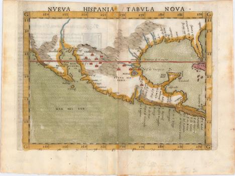
Nueva Hispania Tabula Nova This is a foundation map in the cartography of the American Southwest, and a must for collectors of that region. It is an enlarged version of Gastaldi`s map of 1548 with the only notable change being the peninsular Yucatan. The legendary seven cities of Ciuola are prominently depicted and Mexico City is shown floating in a large lake. The place names along the upper Gulf Coast reveal the explorations of Pineda, Cabeza de Vaca and Moscosso. The Mississippi makes its appearance as the Rio de Spiritu Santo and the R. Tontonteanc flows in the vicinity of the Colorado River. Considered the earliest relatively obtainable map of Mexico and the American Southwest. This is the first state according to Burden. Latin text on verso.See also lot 737 for the first edition of Ruscelli`s atlas, La Geografia de Claudio Tolomeo Allessadrino A dark impression on watermarked paper with faint offsetting, light text show-through, and minor toning along centerfold. 7.3"" W x 9.5"" H Ruscelli, Girolamo 1564

Hispania Nova This is one of the earliest maps of the American Southwest and Mexico, including the southern part of present-day Texas, here called Floridae Pars, with the Rio Grande, labeled R. de Palmas. The map concentrates on the Spanish area of influence and is one of nineteen regional maps of the Americas contained in Wytfliet`s atlas, which was the first devoted exclusively to the New World. Stipple engraved seas, calligraphy and a decorative title cartouche adorn the map. Fine impression and color on watermarked paper with two soft creases and light printer`s ink residue. 9"" W x 11.3"" H Wytfliet, Cornelis 1598

Le Nouveau Mexique avec la Partie Septentrionale de lAncien, ou de la Nouvelle Espagne This small and attractive map details the region from West Florida through California and northern Mexico. In Texas, there is a city named Texas and a notation concerning the death of the explorer La Salle. There is excellent detail, particularly of the Jesuit missions in Mexico and the Southwest. In present-day Arizona, the Gila River is named Rio de los Apostolos. The map is filled with place names and Indian villages, particularly in today`s Arizona and New Mexico. The Baja peninsula is wildly misshapen. A nice impression with minor soiling and a few faint extraneous creases at bottom. 8.1"" W x 12.4"" H Bonne, Rigobert 1780

Spanish Dominions in North America An uncommon map by Arrowsmith that shows an oddly shaped western coast of Mexico, names the town of Texas on the Rio Colorado or Cannes R, locates the fictional Quivira, and much more. This copper engraved map further shows numerous place names, provinces, topography, missions, towns, forts and Indian tribes. The relief is shown by hachure and the seas are fully engraved with closely placed ruled lines. A simple title cartouche floats in the lower left. A rarely offered and desirable map of the Southwest. Light damp stains at left and bottom right with a worm track in the bottom right corner of the sheet, away from map image. 8"" W x 9.5"" H Arrowsmith & Lewis, 1804

Spanish North America The Spanish possessions in North America are the focus of this large, significant map. Especially noteworthy is the delineation of the great western river systems - particularly the Platte flowing east and south of the Rocky Mountains. The conflict between the United States and Spain at the beginning of the 19th century is vividly illustrated on this map. Spanish control of the southwest region is limited to part of Texas and a strip of land in present day New Mexico that includes Santa Fe and Albuquerque. East of that is a huge Louisiana Territory, and the country to the west is unnamed and largely Unknown Parts. A city named Texas appears near present-day Austin, within the province of St. Louis de Potosi, which is also labeled New Santander. In this edition, Pikes Peak is not named but is labeled as the Highest Peak. According to Wheat, the map originated primarily from the epic Humboldt and Pike maps and to some extent the Pinkerton and Arrowsmith maps published a few years earlier. This very handsome map names many Indian tribes and villages, with terrific early information on topography and watershed. Original color with minor soiling and a 4.5"" fold separation at top and a 0.5"" edge tear at bottom that have been closed on verso with archival tape. 20"" W x 24.3"" H Thomson, John 1814
![[Lot of 2] Mexico [and] Possessioni della Spagna nell` America Settentrionale o Carta Generale del Messico This lot includes](http://lot-images.atgmedia.com/SR/36385/2916721/320-201411614401_468x382.jpg)
[Lot of 2] Mexico [and] Possessioni della Spagna nell` America Settentrionale o Carta Generale del Messico This lot includes two uncommon maps of Mexico and the American Southwest. The first, by John Cary, shows Texas appearing within the province of ""San Luis Potosi."" In the Valle Salado (present-day Utah) is a lake with the notation ""Western Limits of this lake are unknown."" Many Indian tribes and villages are named, with roads, topography and watershed also shown. The second map is an Italian map from Nuovo Atlante di Geografia universale in 52 Carte.... engraved by F. Bordiga and published in Milan by Luigi Rossi and Vincenzo Batelli. The cartography is broader than the first, covering an area from the Southeast west to San Francisco. Very early place names are identified in the Southwest and Florida is divided into East and West. A. Mexico, by John Cary, dated 1816 (9.2 x 11.4""). Condition: Original color with wide margins on thick paper. There is one small spot in the image and some light dampstaining confined to the lower right blank margin. B. Possessioni della Spagna nell` America Settentrionale o Carta Generale del Messico, by Luigi Rossi & Vincenzo Batelli, circa 1820 (9.8 x 7.8""). Condition: A clean, bright example with wide margins, light printer`s ink residue, and just a few spots of foxing confined to the far blank margins. See description See description 1816-20

Mexico und Centro-America Handsome and finely engraved map that includes portions of central, southern and western America. Texas is shown as a small state with its northern boundary ending well south of the Red River. Neu Mexico is a narrow strip of land that follows the Rio Grande del Norte to just north of Taos, naming Santa Fe and Albuquerque. Neu Californien is well detailed and shows numerous coastal cities and missions including S. Diego, S. Juan [Capistrano], San Carlos del Monterey, and San Francisco. An inset of Mexico City and its lakes is at lower left. Tables list the states of each region. Drawn by Von Stulpnagel. A crisp impression with original outline color on a clean sheet. 12"" W x 14"" H Stieler, Adolph 1828

Mexico & Guatemala This map of the southwest shows Texas as still a part of Mexico with Austins Colony noted. Sonora extends north into present-day Utah and is wedged between New Mexico and Upper California. The rivers Timpanogos and San Buenaventura run straight through the Great Basin into the Pacific. Insets include the Valley of Mexico and Guatemala. The map presents a great picture of the region prior to Texas declaring its independence. Original color with one small spot in New Mexico, else fine. 11.7"" W x 14.7"" H Tanner, Henry Schenck 1834

Texas and Part of Mexico & the United States, Showing the Route of the First Santa Fe Expedition This map shows the failed Republic of Texas expedition, under President Mirabeau Lamar, to gain jurisdiction over Sante Fe and develop trade links between Texas and New Mexico. Many enterprising Texans believed New Mexico would be interested in this relationship, but upon the partys arrival in Sante Fe, they were met by 1,500 Mexican troops. Spared their lives, the Texan party was forced to march the 2,000 mile route to Mexico City before diplomatic measures guaranteed their release a year later. Also depicted on the map is Josiah Greggs route from Van Buren, Pikes route from Ft. Smith, and the Chihuahua Trail. Published in George Kendall`s Narrative of the Texan Santa Fe Expedition. Issued folding with light printer`s ink residue and a binding trim at right and associated 1.5"" binding tear closed on verso with archival material. There are a few misfolds and short fold separations that have been archivally repaired. 15.8"" W x 12"" H Kemble, W. 1844

Audience de Guadalajara Nouveau Mexique, Californie, &c. This map was first published in 1656 and introduced the so-called second Sanson model of California as an island. This depiction shows a small peninsula (Agubela de Cato) above the island, two bays along the island`s northern coast and two new place names, Tolaago and R. de Estiete. Sanson actually based this on information from the less well known map by Luke Foxe, but it was this map that influenced many other cartographers throughout the rest of the century. On the mainland there are new Indian tribes identified in the region of the R. del Norte, which flows southwest from a large inland lake. The map was re-engraved for this edition, with only very minor differences from Sanson`s map of 1657. This is the second state of the Ribbius edition, with the addition of a grid of longitude and latitude. A dark impression, issued folding, with minor printer`s ink residue and a professionally repaired tear confined to right blank margin. 8"" W x 9.4"" H Sanson, Nicolas 1700
-
108737 item(s)/page