We found 109182 price guide item(s) matching your search
There are 109182 lots that match your search criteria. Subscribe now to get instant access to the full price guide service.
Click here to subscribe- List
- Grid
-
109182 item(s)/page


Lot 409
GWR Wellington and Drayton Railway Survey 1882 as corrected by the Engineer 28th August 1895 ref E14/13, a London Transport Operating Department Trams and Trolleybuses Rule Book for Drivers and Conductors with an amendment dated December 1944, London Transport Tramway Pocket Maps dated 1927 and 1935 and a Trolleybus and Tram Map dated 1938. A quantity of Buttons most LT related.


Lot 9
John Barrow An Account of Travels Into the Interior of Southern Africa in the Years 1797 and 1798 (1802) 14x21.5cm An Account of Travels Into the Interior of Southern Africa in the Years 1797 and 1798; including cursory observations on the geology of the southern part of that continent; the natural history of such objects as occurred in the animal, vegetable and mineral kingdoms; and sketches on the physical and moral characters of the various tribes of inhabitants surrounding the settlement of the Cape of Good Hope. To which is annexed a description of the present state, population and produce of that extensive colony; with a map constructed entirely from actual observations, made in the course of the travels. By John Barrow, late Secretary to the Earl of Macartney, and Auditor-General of Public Accounts at the Cape of Good Hope. The First American from the London quarto edition. New cloth boards with gilt titles on spine in protective Brodart, new endpapers, [4] + 386 + folding map. Pages and map browned and foxed, previous owner`s Ex Libris stamp on inside front, small stamps and catalogue numbers appear on three pages, a tight and well preserved copy. Very Good New York GF Hopkins 1802 Click here to view further details and images and to bid

Lot 11
Mandela, Nelson The Long Walk to Freedom (INSCRIBED & SIGNED to Soweto `Unrest` Police Officer + 3 Signed letters from Minister of Law and Order and Police Commanders) 8vo Hard cover, end papers feature a map of South Africa, illustrated with b&w photographs, pp. 630, text pages generally clean, DJ creased and worn at extremities and spine, dirt and liquid marks on inside of DJ, boards are rubbed, worn at spine ends and there is a bit of loss to map area on inside front and the top rear corner. INSCRIBED and SIGNED by Nelson Mandela on 27/10/95 on the title page. With three original letters in Afrikaans to JB Facer (Captain, Major, Lieutenant-Colonel) congratulating him on his promotion; 1) Signed letter from Minister of Law and Order, Adriaan Vlok (1989); 2) Signed letter by Lieutenant-General J Swart, SA Police Divisional Chief of Internal Stability (1993) and 3) Brigadier LAH Nortje, SAP Regional Coordinator. The A4-size letters are creased and slightly faded. Facer, was stationed in Soweto and served as an Internal Stability Unit (number 3) officer in the SA Police and later SA Police Services. This Unit was also known as the `Riot Control` Unit. They were responsible for additional security when Mandela visited Soweto in the period leading to the 1994 elections and thereafter. Good Randburg Macdonald Purnell 1995 Click here to view further details and images and to bid

Lot 15
Conder, Josiah A Popular Description of Africa: Geographical, Historical, and Topographical in 3 Volumes (1829) 9.8x15.3cm Hard cover, brown boards, Volume 1: Fold out map of Africa at the frontis + 374 numbered pages, three plates (complete). Boards have separated from text blocks which are still intact. Volume 2: pp. iv + 348, 6 plates (complete). Rear hinges cracked text blocks intact. Volume 3. pp. v + 323, 2 plates (complete), of Cape Town and Bethelsdorp. Front and rear hinges cracked but text blocks intact. Foxing on end papers but text pages in all 3 volumes are clean. Boards rubbed and faded. Fair/Binding copies London James Duncan c1829 Click here to view further details and images and to bid
Lot 16
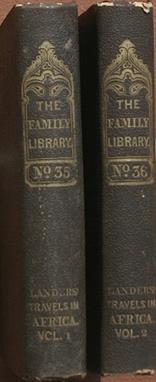
Lander, Richard & John Journal of an Expedition to Explore the Course and Termination of the Niger in 2 Volumes (c1832) 10x15cm The Landers were commissioned by the British Colonial Office to complete what had been left undone by the Clapperton expedition to the Niger River. They mapped the Niger from its source to where it emptied into the Bight of Benin. First American Edition, issued the same year as the London edition. The plates and maps are a mix of wood and steel engravings, stipple engravings, etc. In series: `Harper`s family library`. 2 vols. I: frontis + xiii + map + 384 + 2 maps (one fold.). II: frontis + 7pp + 337 + 2pp advertisements + 3 plates. Light wear to boards, spine ends slightly chipped, foxing on first and last pages of each volume and inscriptions on inside front covers, otherwise clean, tightly bound and very good copies. Good+ New York J & J Harper c1832 Click here to view further details and images and to bid

Lot 33
Christopher (J.S.) NATAL, CAPE OF GOOD HOPE 8vo (225 x 140 mm) a Grazing, Agricultural, and Cotton-growing country. Comprising descriptions of this well-endowed Colony from the year 1575 to the present time, by Government Officials and Travellers. With a Map of the Colony, and Engravings. With an Appendix, and a Vocabulary of the Natal or Zulu language. 146 pages, folding colour map as frontispiece, neatly repaired at folds (the paper is brittle), 4 tinted lithographic plates, errata slip tipped in opposite page 43, Addenda (pages 145/6) dated September 1850, full black calf with gilt borders and with red title label on the spine A South African Bibliography, volume 1, page 523, and volume 5, page 69, Mendelssohn (Sydney) South African Bibliography, volume 1, page 336, ‘The author was a staunch believer in the virtue of colonisation as a means of lessening suffering and poverty and he states that he “promoted emigration to Algoa Bay”?There is a short description of the country, with information of every description for the use of the colonists, together with article, contributed by various writers?’ Good London Effingham Wilson; Hatchard and Sons & Trelawny Saunders 1850 Click here to view further details and images and to bid

Lot 34
Latrobe (Rev. C.I.) JOURNAL OF A VISIT TO SOUTH AFRICA, IN 1815 4to (270 x 220 mm) With Some Account of the Missionary Settlements of the United Brethren, near the Cape of Good Hope. 406 pages, folding coloured map as frontispiece with the author?s outward and return journeys outlined in red and blue, 12 fine hand coloured aquatint plates drawn by R. Cocking from sketches by the author, and 4 uncoloured plates, recent quarter blue leather titled and decorated in gilt on the spine, marbled paper sides, fold in title page strengthened with Japanese paper,some light foxing, the plates are crisp and well coloured. `South Africa in Print` comments about Latrobe that `He has left an important volume of travels with illustrations second only to those of Burchell`. Colvin in his introduction to Mendelssohn`s `Bibliography` describes the Journals as `written with much sweet piety and simplicity of spirit, yet (he) shows shrewdness of observation and a fine common sense.` Good London Published by L.B. Seeley 1818 Click here to view further details and images and to bid

Lot 50
A. Wilmot. HISTORY OF THE ZULU WAR. 8vo Gilt title on red labels, brown half leather with green boards. raised bands & reproduction marbled endpaperss. vii + 249pp + advts. tissue-guarded frontis, foldout map, original sepia tipped-in photograph frontis. Newly rebound. ff a little browned else an attractive copy. Map & frontis in excellent condition. Includes appendix of articles originally published in the PE Telegraph including the despatch from Pietermaritzburg by Bartle Frere of February 12th. VG+ London & Cape Town Richardson & Best & A. White 1880 Click here to view further details and images and to bid

Lot 61
MacGregor Laird, & R.A.K. Oldfield. NARRATIVE OF AN EXPEDITION INTO THE INTERIOR OF AFRICA BY THE RIVER NIGER In The Steam Vessels Quorra And Alburkah, In 1832, 1833, And 1834. 8vo 2 volumes. Rebound black full leather blind tooled front & rear, raised bands to spine with 6 panels with gilt on green leather title labels. Nicely executed, edges left rough-cut, marbled eps. 5 illustrations plus map. Volume 2 top corners bumped. ff are tanned & spotted, the plates quite heavily. overall a sound and attractive set. In 1831 Laird formed a company for the commercial development of the Niger regions, the lower course of the Niger having been made known that year by Richard and John Lander. In 1832, the company sent two small ships to the Niger, the Alburkah, a paddle-wheel steamer of fifty-five tons designed by Laird, the first iron vessel to make an ocean voyage, and the Quorra. Laird went with the expedition led by Richard Lander and forty-eight Europeans, all but nine of whom died from fever, Lander, from wounds. Laird went up the Niger to the confluence of the Benue which he was the first white man to ascend. He did not go far up the river but formed an accurate idea as to its source. VG London Richard Bentley 1837 Click here to view further details and images and to bid

Lot 115
Henry Brooks- Edited by Dr. R.J.Mann NATAL; A History and Description of the Colony: Including its Natural Features, Productions, Industrial Condition and Prospects. 15 X 23cm Original maroon boards with gilt lettering to spine, and being Natal; A History and Description of the Colony: Including its Natural Features, Productions, Industrial condition and prospects. Edited by Dr. R.J.Mann. Coloured Frontispiece(Palmiet River) with tissue guard, A further 15 illustrations occur in the book including some full colour flora plates-Physical and Topgraphical Map of the Colony/Plan of the Inner Bay or Harbour/Sandstone Wall on the Shoulder of Pietermaritzburg Table Mountain/Mines at the Diamond Fields on the Vaal River/The Valley of the Umgeni/The Lower Falls at Howick/Glade at Aliceville/Euphorbia Caput-Medusae/Arduinia Grandiflora/Scarlet Cyrtanthus/Thunbergia Natalitia/Portrait of Langalibalele, Chief of the Amahlubi Kaffirs/Mission onn the Hills near Verulam and Kranzekop,overlooking the Tugela Valley. 326 pages text plus a 16 page advertisement slot. Very clean copy. Very Good-All 16 illustrations & Plates Henrietta Street-London L.Reeve & Co 1876 Click here to view further details and images and to bid

Lot 148
Ellen Hellmann HANDBOOK ON RACE RELATIONS IN SOUTH AFRICA 250 x 180 x 53 mm 31 well-known South Africans have contributed to this detailed handbook. Published in 1949 for the SA Institute of Race Relations, with chapters on, for example, Population, Government & Admin, Labour, Trade Unions, Land and Agriculture, Indian Land legislation, Pass Laws etc. Historically interesting because it was published just at the time the Nationalist Government took over. Fold-out map of Native Reserves in SA. Pages [i-vii]viii-xii pp 1-778. DJ tor, faded, dirty and crumpled, but holding together - poor condition. Book has blue cloth-covered boards, faded along the edges and spine top and bottom, water blot on front cover, but book is in Good condition. London Oxford University Press 1949 Click here to view further details and images and to bid

Lot 225
Captain William Cornwallis Harris Wild Sports of Southern Africa (1844) 8vo,(180 x 245) The Wild Sports of Southern Africa, being the narrative of an expedition from the Cape of Good Hope, through the territories of the Chief Moselekatse, to the tropic of Capricorn, 26 colour plates, map,360pages, condition:very good. very good London Pelham, Richardson 1844 Click here to view further details and images and to bid

Lot 235
E D Young The Search after Livingstone: A Diary kept during the investigation of his reported murder in present day Malawi A Facsimile edition of the 1868 text published by the Society of Malawi in association with the Royal Geographical Society. 262 pages and a pull-out map at rear. Number 494 of a limited numbered copies. Very good London 1984 Click here to view further details and images and to bid

Lot 236
G B Beak The Aftermath of War: An account of the repatriation of Boers and Natives in the Orange River Colony 1902-1904 A rare to find copy printed 1906. 296 pages, content page, index, pull-out map at back. A few inscriptions in pencil throughout book. Illustrations on Vaal River near Venterskroon, Aliwal North, Springfontein Refugee Camp, Jammersberg Drift, waggons on trek and more. The serious collector would probably do some rebinding of the spine. Name of previous owner in front in ink. Fair London 1906 Click here to view further details and images and to bid

Lot 247
SPEKE J H Journal of the Discovery of the Source of the Nile 230 x150 mm One of the iconic works of African exploration - the two explorers` discoveries had great geographical significance at the time and solved one of the great mysteries of the continent, even if only partly.xxxi, 658 pp, frontis (portrait of Speke), 25 plates + many text illus mainly by Grant, spot colored map in facsimile (in rear pocket showing route in red), and sketchmap in text [xxxxii, ads]. Original boards, re-backed with original backstrip laid down, eps replaced Very good London William Blackwood 1863 Click here to view further details and images and to bid

Lot 248
McLEOD L Travels in Eastern Africa, with a Narrative of a Residence in Mozambique, 2 vols 195 x 140 mm The author spent some time in South African and then went on to Mozambique where he was the British Consul for a period. Much of the book is on the produce and commerce of the region and the effects of continued slavery. The author experienced the conspiracies between slavers and government officials personally and was at one stage attacked. 341+347 pp, with frontis and vignette in each volume plus folding map. In original blind-stamped covers, hinges cracked externally, but holding; new endpapers have been fitted and the seal of the Munger Africana Library has been impressed on the titlepages Very good London Hurst & Blackett 1860 Click here to view further details and images and to bid

Lot 249
ELLIS W Madagascar Revisited 210 x 135 mm Second book by this author on the people of the great island. As a missionary, he naturally focuses on the Christian martyrs and their persecution, but gives a fair account of the state of the population and their prospects both economically and politically. 502 pp with frontis and twelve engraved plates, NB folding map at front is missing - otherwise a beautiful volume. Beautifully bound in full calf prize-binding with lavish gilt decoration to covers and edges. Marbled endpapers and bookplate, all edges gilt. Very good London John Murray 1867 Click here to view further details and images and to bid

Lot 250
MONTEIRO J J Angola and the River Congo, 2 Vols 190 x 130 mm Account of the interior of Angola and the Congo by an obscure, yet very observant explorer of Portuguese origins. He studied geology in Britain and his main aim in West Africa was the search for minerals. However he wrote down important data on the region, its fauna and flora as well as on the culture of the inhabitants. He died shortly after the completion of the work. 303 + 340 pp, this edition the scarce one with colour plates and map. Recovered in green buckram with original gilt decoration and spine panel laid down on covers. Very good London Macmillan 1875 Click here to view further details and images and to bid
Lot 277
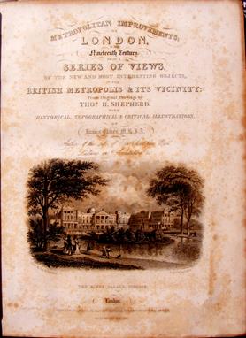
Thos.H.Shepherd & James Elmes M.R.I.A. London in the Nineteenth Century (1831) 220 x 280mm Metropolitan Improvements; or London in the Nineteenth Century: displayed in a series of engravings of new buildings, improvements, &c. By the most eminent artists from Original Drawings, Taken from the objects themselves expressly for this work, by Mr Thos. H. Shepherd: comprising The palaces, New Churches, Bridges,Streets, River Scenery,Public Offices and Institutions,Gentlemen`s Seats, and Mansions,and every other object worthy of notice throughout the metropolis and its Environs.With Historical, Topographical, and Critical Illustrations , By James Elmes ,M.R.I.A. Architect, Author of the Life of Sir Christopher Wren, Lectures on Architecture, Dictionary of the Fine Arts, & c. Jones & Co., dedication to George IV, who has taken this work under his protection, 172 pages of text by Elmes, also series one of the engravings from steel plates by Shepherd comprising the Earlier Edifices, Antiquities, & c., 152 steel plate engravings (approx.), map of Regents Park, published 1829, half leather on marbled boards, 220 x 280 mm, condition of casing:fair, condition of binding:goodA group of young men met on 13 January 1834 at 17 Suffolk Street, Pall Mall East,‘to receive the outlines of a plan for forming an Architectural Institution, similar to the Institution of Civil Engineers, for the purpose of promoting the practical, as well as the more scientific interests of the profession’ (Bell`s Weekly Messenger, 18 Jan 1834, 10). James Elmes chaired that meeting. At a subsequent meeting on the 3rd february it was agreed to appoint a committee ‘to prepare the necessary measures for forming a Society to be called the Institution of British Architects’.(Oxford Dictionary of National Biography)Thomas H. Shepherd was known for his lifelike scenes and attention to detail in his architectural drawings. He worked for Frederick Crace, decorator to George IV, who commissioned him to reproduce old London buildings before they were torn down. good London Jones & Co. 1831 Click here to view further details and images and to bid
Lot 301
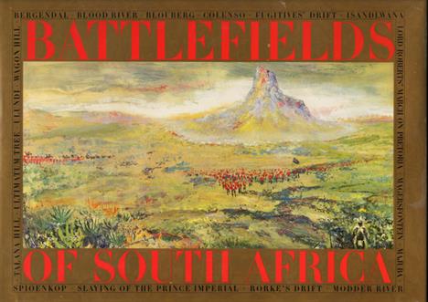
Van Lingen (Gail) BATTLEFIELDS OF SOUTH AFRICA Oblong folio (310 x 425 mm) Paintings by Gail van Lingen. Accounts of the battles by George Chadwick, George Duxbury, John Laband, Pamela McFadden, Jeffrey Mathews, Gilbert Torlage. 144 pages, coloured map as frontispiece, 19 colour plates, numerous black & white illustrations from old photographs, sketches and engravings, 17 battle maps, grey paper covered boards, light foxing on the half title page, frontispiece, title page and final three pages, otherwise the contents are good. Good Johannesburg Times Media with Jonathan Ball 1991 Click here to view further details and images and to bid

Lot 326
Capell (Lt.-Col. A.E.) THE 2ND RHODESIA REGIMENT IN EAST AFRICA. 8vo (230 x 150 mm) 132 pages, folding map as frontispiece, 4 sketch maps, original blue cloth gilt, light foxing on the title page and uncut page edges, the binding is slightly strained but all the pages are unopened and thus an unread copy. Good London Simson & Co., Ltd. 1923 Click here to view further details and images and to bid

Lot 331
George Carter The Wreck of the Grosvenor (reprint) 145 x 205mm Softbound facsimile reprint, THE WRECK OF THE GROSVENOR: containing a Narrative of the Loss of The Grosvenor, East Indiaman, wrecked on the Coast of Caffraria, 1782; by Mr.George Carter from the examination of John Hynes,one of the survivors: And JOURNAL OF A JOURNEY from the Cape of Good Hope undertaken in 1790 and 1791, by Jacob Van Reenen and others of his Countrymen, in Search of the Wreck of the Honourable The East India Company`s Ship The Grosvenor to discover if there remained alive any of the unfortunate sufferers. With additional notes, and a map by Capt. Edward Riou (1792). With a Preface by C. Graham Botha, M.A., Van Riebeeck Society for the Publication of Southern African Historical Documents, fold-out map, 207 pages,145 x 205mm, condition:very good. The Grosvenor was a three-masted East Indiaman of 729 ton displacement on her return voyage (to England) when she was wrecked ( 4 August 1782 ) on the Pondoland coast. She was carrying a crew of 132 and 18 passengers (12 adults and 6 children) with a cargo valued at £75,000. Of the 123 survivors, only 18 reached Cape Town and were repatriated to England. the remainder dying of their injuries or trying to reach safety. Others were killed , or joined local Bantu tribes. This latter aspect is still contentious and is covered by Hazel Crampton in `The Sunburnt Queen` and Stephen Taylor`s, `Caliban`s Shore: The Wreck of the Grosvenor and the Strange Fate of Her Survivors`.These facsimile reprints were originally published in 1791 and 1792. very good Cape Town Van Riebeeck Society 2008 Click here to view further details and images and to bid

Lot 335
Casalis, Rev. E. The Basutos; or, Twenty-Three Years in South Africa (De luxe edition) 207mm x 136mm This is the 16th title in the Africana Collectanea series. Copy number 29 of the de luxe edition bound in leather and limited to 50 copies. The total print run was 750 copies, including the standard edition. Original brown leather spine and corners with a green title panel on the spine and gilt titling with the publisher`s device on the upper board. 8 prelims, followed by a facsimile of the 1861 edition with xix prelims, 361 pages, a folding map and 29 illustrations. CONDIYION DETAILS: The yellow tinting on the frontis normally leaves some off-setting on the title page, as in this copy. A lightly used copy. A clean copy Cape Town C. Struik 1965 Click here to view further details and images and to bid

Lot 336
Chase, John Centlivres The Cape of Good Hope and the Eastern Province of Algoa Bay, etc. etc. With Statistics of the Colony (De luxe edition) 195mm x 118mm This is the 25th volume in the Africana Collectanea series. Copy number 40 of the de luxe leather bound edition limited to 50 copies. The total print run was 750 copies, including the standard edition. Original brown leather spine and corners with a green title label on the spine with gilt titling and the publisher`s device on the upper board. 6 prelims, followed by a facsimile of the 1843 Pelham Richardson, London editio, xvi prelims, 338 pages, a new index taking the pagination to 358, a large folding map with four pictorial views, black and white illustrations. CONDITION DETAILS: A few signs of light use. Sight toning to the end papers. A booksellers label on the front paste down. A clean copy Cape Town C. Struik 1967 Click here to view further details and images and to bid

Lot 337
Hensman, Howard Cecil Rhodes - A Study of a Career (De luxe edition) 219mm x 146mm This is the 46th volume in the Africana Collectanea series. Copy number 19 of 50 de luxe copies that were bound in leather. The total edition, including the standard edition was limited to 1,000 copies. Most of the titles in the series are facsimiles, but this edition is called the second edition, the 1901 William Blackwood edition being the first. xvi prelims, 382 pages, 6 black and white illustrations and a large folding map of Rhodesia at the rear. CONDITION DETAILS: A lightly used copy. Bookseller label on the front paste down. A clean copy Cape Town C. Struik 1974 Click here to view further details and images and to bid

Lot 343
Anderson, Andrew A. Twenty-Five Years in a Wagon. Sport and Travel in South Africa (De luxe edition) 219mm x 149mm This is the 48th volume in the Africana Collectanea series. Copy number 47 of 50 de luxe copies bound in leather. Including the standard edition, the total print run of this edition was limited to 1,000 copies. Original brown leather spine and corners with a green title label on the spine and gilt titling and the publisher`s device on the upper board. The lay out of this edition follows that of the `New Edition in One Volume` of 1888 published in London by Chapman and Hall. xiii prelims, 427 pages, 14 illustrations and a fold out map at the rear. CONDITION DETAILS: The title label is holding firm, but the edges are not properly glued down. Bookseller label on the front paste down. A previous owner had a plastic covering, which when removed, left some tape residue marks on the end papers. Attractive Cape Town C. Struik 1974 Click here to view further details and images and to bid

Lot 347
John Martineau The Life and Correspondence of Sir Bartle Frere - Two vol set (includes letters) Contains original letter in envelope from Sir Bartle`s wife, Catherine to John Richards esq, Secretary to the Divisional Council, Cape of Good Hope after Sir Bartle Frere`s death. Vol 1: xi, 516p, frontispiece portrait, sketches, 3 single page maps, 2 fold-out maps (Sind and India). Vol 2: vii, 469p. frontispiece, sketches, fold-out route map of Zanzibar mission, fold-out map of South Africa. Original maroon cloth with gilt Frere coat of arms on front boards, gilt lettering on spine. Corners are bumped, stickers on spine. Head and foot of spine are slightly worn and some damage to cloth edges in places. There are a few holes (insect) on front paste-down and first few pages of Vo 1. Ex-libris bookplate of Sir Hugh Clifford on front paste-down. C. Frere`s name stamped on ffep, also Gertrudae A. Frere`s name in faded ink and date of 1903. Fair London John Murray 1895 Click here to view further details and images and to bid

Lot 373
Gunn, Mary + Codd, L.E. Botanical Exploration of Southern Africa 283mm x 208mm ..`An illustrated history of early botanical literature on the Cape flora. Biographical accounts of the leading plant collectors and their activities in southern Africa from the days of the East India Company until modern times.` This is the introductory volume to the Flora of Southern Africa series. Original dust jacket with a colour plate tipped onto the upper side. Original dark green cloth boards with gilt titling on the spine and the publisher`s device on the upper board. xiv prelims, 400 pages, tipped-in colour frontispiece, double page map, profusely illustrated in black and white. CONDITION DETAILS: The spine of the dust jacket is a bit sun faded and there is a chip, less than 1cm, at the base of the spine. A clean copy Cape Town A.A. Balkema for Botanical Research Institute 1981 Click here to view further details and images and to bid

Lot 386
Smith, Professor J.L.B. The Sea Fishes of Southern Africa (SIGNED) 285mm x 222mm Signed and dated by Margaret M. Smith, an illustrator of this work - see images. Original dust jacket. Original light green/blue cloth boards with gilt titling on the spine and a decorative device on the upper board. The top edge is also a green/blue colour.Dark green decorated end papers. xvi prelims, coloured map, 580 pages, profusely illustrated in full colour and black and white, with a total of 111 full page plates. CONDITION DETAILS: A previous owner wrote his name in pen on the free front end paper. The dust jacket is worn and creased in several places with some closed tears. A very reasonable copy Cape Town Central News Agency 1965 Click here to view further details and images and to bid

Lot 387
Smith, Professor J.L.B. The Fishes of Seychelles (SIGNED) 285mm x 214mm The Research Associate and Artist, Margaret Mary Smith, signed and dated this copy - see images. Original dust jacket. Original blue cloth boards with gilt titling on the spine and a decorative device on the upper board. Map motif end papers. 8 prelims, black and photographic frontispiece of Port Victoria, 215 pages, profusely illustrated in full colour as well as black and white, with a total of 98 full page plates. CONDITION DETAILS: There are several signs of use, such as the previous owners name on the free front end paper, the dust jacket is a bit worn but is still attractive, etc. Attractive Grahamstown Rhodes University 1963 Click here to view further details and images and to bid

Lot 49
GAUTIER (THÉOPHILE FILS) - Aventures Du Baron De Munchhausen, illustrated by Gustave Dore, new edition, a.e.g., dec. red cloth; J Long (William)-Brier-Patch Philosophy by Peter Rabbit, illustrated by Charles Copeland, Boston & London 1906, orig. dec. green cloth; Potter (Beatrix) - The Tale of Jemima Puddle-Duck, Warne & Co. London; Chichester (Francis) - Pinpoint The Bomber, London, George Allen, 1942; Johnston (W&AK) War Map Paris to Berlin, folding linen backed map; Haggard (H. Rider) - Queen Sheba's Ring, London G. Bell & Sons Ltd, 1910, pub. for circulation in India and the colonies (6)


Lot 89
A German porcelain small figural timepiece Unsigned, late 19th century The Swiss five-bar watch type movement with cylinder escapement regulated by sprung monometallic balance, the circular white enamel Roman numeral dial with red Arabic five minutes to outer track and fine pierced gilt hands within convex glazed milled brass bezel, set in a polychrome painted porcelain case modelled as a globe stood on a stack of books draped with a map beside a figure of a standing cherub holding sprays of flowers, on square plinth base with gilt repeating panel decoration, the underside bearing underglaze blue mark for Frankenthal, 18.5cm (7.25ins) high.


-
109182 item(s)/page