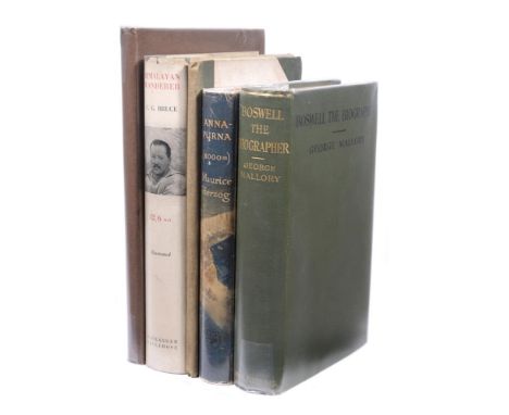

Ɵ MOUNTAINEERING & RELATED: a group of Five Works: two volumes SIGNED. 1912- 1945. comprises: HERZOG, Maurice. (1919 - 2012). Annapurna Conquest of the First 8000-metre Peak. SIGNED. Jonathan Cape, 1952. first edition, 8vo., (200 x 140mm), publisher's blue cloth, gilt lettering to spine, dustwrapper unclipped, introduction by Eric Shipton, translated from the French by Nea Morin and Janet Adan Smith, half-title, SIGNED and dated 17 July 2000 by the author to title page, 27 illustrations, 9 maps, folding panorama at end, 288pp: BRUCE, Charles Granville. (1866 - 1939). Himalayan Wanderer. London: Alexander Maclehouse & Co., 1934. first edition, 8vo., (240 x 160mm), publisher's black lettered cloth, portrait frontispiece, 22 photo. illustrations, 309pp: ABRAHAM, Ashley Perry. (1876 - 1951). Some Portraits of the Lake Poets and their Homes. Presentation copy. G.P. Abraham, Keswick, 1913. hardback edition, brown illustrated paper covered boards, black lettering to front, INSCRIBED and dated by the author to front e/p., 'To Mrs. Collins / with kindest regards / from / Ashley P. Abraham / April 1915', 29 full-page monogravure illustrations, publisher's leaf at end, 55pp: MALLORY, George. ( 1886 - 1924). Boswell the Biographer. London: Smith, Elder & Co., 1912. first edition, 8vo., 210 x 150mm), publisher's black lettered green cloth, gilt lettering to spine, foredge and lower edge untrimmed, portrait frontispiece with tissue guard, publisher's advert at end, 337pp. each volume within removeable clear wrapper: NOYCE, C.W.F. and others. A Climber's Guide to Sonamarg Kashmir. Frontier Exchange Press Ltd., the Himalayan Club. n.d. (1945). first edition, 8vo., (230 x 140mm), 5pp. introduction with articles by J.A. Jackson, C.W.F. Noyce, and T.H. Tilly, previous ownership inscription to front pastedown, 12 illustrations including frontispiece, folding map at end, 51pp. (5) Condition Report: 1. Annapurna -corners scuffed, spine a little faded and bumped head/tail, dustwrapper with wear at edges and foxing to inside flaps, toning to leaf edges and a few minor marks internally. 2. Himalayan Wanderer - clean boards, corners scuffed, dustwrapper marked, with chips and small edge tear (with loss) to top of spine, foxing to edges and e/ps., some toning to a few pages. 3. Some Portraits of the Lake Poets - boards with light marks, lower corners scuffed, spine bumped head/tail and torn to top of spine, foxing to edges, front free e/p. toned and foxed with further sporadic foxing to some pages. 4. Boswell the Biographer - clean boards, front corner scuffed, spine bumped head/tail, foxing to edges, and further sporadic foxing to some pages. 5. A Climber's Guide to Sonamarg Kashmir - boards marked, lacking front e/p., foxing to edges, and further sporadic light foxing to some pages, map clean. Condition Report Disclaimer
We found 109198 price guide item(s) matching your search
There are 109198 lots that match your search criteria. Subscribe now to get instant access to the full price guide service.
Click here to subscribe- List
- Grid
-
109198 item(s)/page
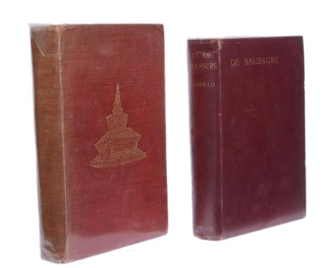
Ɵ FRESHFIELD, Douglas W. (1845 - 1934). Two Works: a Presentation copy with author's 4pp. ALS, 1920; and one other volume, 1903. comprises: The Life of Horace Benedict de Saussure, author's Presentation copy. London: Edward Arnold, 1920. first edition, 8vo., (245 x 170mm), publisher's burgundy cloth, gilt lettering to front and spine, map illustrated e/ps., INSCRIBED and dated by the author to half-title, 'Dorothy Hutchinson / from an old affectionate friend / Douglas W. Freshfield / April 1925', portrait frontispiece, numerous b/w. plates, route map of Mont Blanc, with a loosely inserted 4pp. manuscript letter, SIGNED and dated from the author to Mrs. Dorothy Hutchinson, 47 lines, the author's printed address Whych Cross Place, Forest Row, Sussex, and dated 23 February, 1925, 'Here is my heavy production . . . probably read the first chapter, be amused by the second and tolerate the third and fourth. There you had better stop . . . in fact most of the volume has been as much of a failure here . . . most of the {? in French) has been burnt at the publishers - the wretched Mumms!'; the author suggests that Dorothy might be interested in reading The Portrait of Zelide, and after reading this, 'look up the inevitable letter by Boswell (in Vol 1 of his newly published correspondence) proposing marriage to the damn lady -' , Freshfield also makes reference to having put back an offer from Trenton - New Jersey; loosely inserted is an accompanying typed receipt for the purchase of this volume in 1951, from Thomas J. Gaston booksellers, 190 Strand, London priced three guineas. Neate F67. 'This book gained Freshfield an Honorary Doctorate of Laws from the University of Geneva. A delightful study of early mountaineering and life in eighteenth century Geneva.': FRESHFIELD, DOUGLAS W. Round Kangchenjunga. A Narrative of Mountain Travel and Exploration. London: Edward Arnold, 1903. London: Edward Arnold, 1903. first edition, 8vo., (260 x 170mm), publisher's red cloth, gilt vignette to cover, gilt lettering to spine, edges untrimmed, half-title, 41 photographic plates including frontispiece with tissue guard, after Vittorio Sella and others, folding panorama of the Kangchen Glacier, in-text map of Sarat Chandra Das's route map, folding colour sketch map of the Glaciers of Kangchenjunga constructed by Edmund J. Garwood at end, 373pp. 'This dangerous and exhausting circuit of Kanchenjunga is a classic of mountain exploration; his second most important work', Neate F69; both volumes within removeable clear wrapper. Douglas Freshfield was a British lawyer, mountaineer and author, particularly noted for his work in the Caucasus. He edited the Alpine Journal from 1872 to 1880 and was an active member of the Royal Geographical Society, serving as president of both organizations. (4) Condition Report: 1. The Life of Horace Benedict de Saussure - boards bright with minor marks, spine marked and bumped at tail, cloth split and bumped at head of spine, toning mostly to leaf edges, some lower corners of pages creased, joints of upper and lower boards a little weak. 2. Author's 4pp. manuscript note to Mrs. Hutchinson - foxing mostly to the first page with some minor foxing to the last page. 3. Thomas Gaston bookseller's receipt - minor foxing, toning to leaf edges. 4. Round Kangchenjunga. - boards marked and faded, corners scuffed, the top r.h. corner dented, foxing throughout, some creasing mostly to the margins of the folding panorama with two tape repairs to lower l.h. margin edge, the map clean. Condition Report Disclaimer
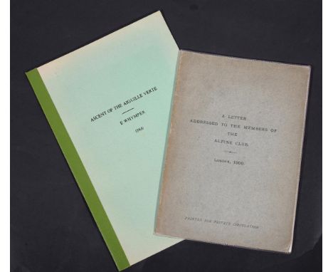
Ɵ WHYMPER, Edward. (1840 -1911). A Letter Addressed to the Members of the Alpine Club. [Printed for Private Circulation by the author]. London, 1900. a 16pp. booklet, original green paper wrappers, lettered in black to front, 8vo., (220 x 153mm), engraved frontispiece after the author, depicting the 'disputed leap' made by the guide Christian Almer during the first ascent of the Western Arete of the Pointe des Ecrins in June 1864; Whymper's detailed letters and witness statements were sent to Club members in response to an accusation made against him by American mountaineer, William Coolidge. Whymper happened upon the accusation in a foot-note of an obituary notice for the late guide, Christian Almer. The article was signed by William Coolidge and published in the Jahrbuch of the Swiss Alpine Club for 1898-1899. Coolidge disputed the 7-8 feet jump did not take place, and was never made by Almer in 1864, (later described in Chapter ix. of Whymper's book, 'Scrambles amongst the Alps'). Coolidge queries 'I find it remarkable that the very detailed report of Mr. Moore on that same expedition did not mention anything about such a jump'. ('The Alps in 1864'). An extraordinary meeting of the Club was held, Rev. William Coolidge removed his name from the list of members, and the Editor of the Jahrbuch, Dr. H. Dubi, admitted his duty should have led him to check if the footnote or any part of it had contained an affront against Mr. Whymper: within removeable clear plastic wrapper: ASCENT OF THE AIGUILLE VERTE [near Mont Blanc]. n.d., (c. 1866). modern green card wrappers. lettered in black to front, chromolithographed plate of the summit, wood-engraved plate, in-text route map, pp. 520-524, Edward Whymper's article originally published in the Leisure Hour, a Victorian monthly, pre-dating the author's work 'The Ascent of the Matterhorn'; Edward Whymper, Christian Almer and Franz Biner first climbed the Aiguille verte on 29 June, 1865, a fortnight before the fateful first ascent of the Matterhorn. Whymper was unable to climb with his usual guide, Michel Croz, who had to wait for a client in Chamonix. As a result, Whymper hired the services of Christian Almer, who had been with Alfred Wills on the Wetterhorn in 1854. (2) Condition Report: 1. A Letter to the Alpine Club - toning to cover edges and spine, edges marked, joints weak and pages loosening (but all attached), a clean copy. 2. Ascent of the Aiguille Verte - some fading and minor marks to green card wrappers, the colour plate of the summit with marks to the margins and edge nicks to r.h. margin, a clean copy. Condition Report Disclaimer
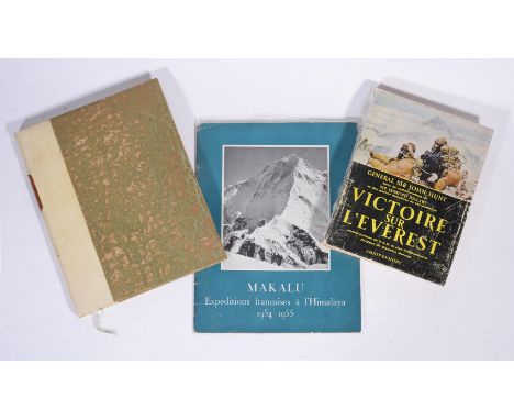
Ɵ HIMALAYAS: a group of Three SIGNED French editions, 1951 - 1954. comprises: HERZOG, Maurice. (1919 - 2012 ). and ICHAC, Marcel. (1906 - 1994). Regards vers L'Annapurna. SIGNED. B. Arthaud, Paris & Grenoble, (1951). second edition, 8vo., (255 x 200mm), rebound half vellum, silk patterned boards, gilt-lettered calf label to spine, gilt patterned e/ps., original colour pictorial wrappers bound in, SIGNED to half-title by Maurice Herzog in blue ink, French text, preface by Lucien Devies, numerous heliogravures, colour illustrations and photographs after Herzog, Ichac, and others, sketch map of the Annapurna and Dhaulagiri bound in, blue silk ribbon book mark, 96pp. An account of the 1950 French expedition in the Himalayas of Nepal: HUNT, General Sir John. (1910 - 1998). Victoire sur L'Everest. [The Ascent of Everest]. Presentation copy, Amoit Dumont, 1953. Library of Mountaineering, Limited edition, number 1 of 1000 copies, 4to., (215 x 160mm), cream paper wrappers, red and black lettering to front, black lettered illustrated spine, dustwrapper unclipped, edges untrimmed, a Presentation copy to Sir Charles Matthews, SIGNED to front free e/p. by John Hunt, George Lowe, George Band, Alfred Gregory, E.P. Hillary, and Maurice Herzog, French text, b/w. photo. illustrated throughout, translated from English by Bernard Pierre, drawings after Charles Evans, preface by Maurice Herzog., 350pp: MAKALU. French Expeditions to the Himalayas 1954-1955, SIGNED, Federation Francaise de la Montagne, 1954. 4to. (280 x 210mm), photo. illustrated soft wrappers, French text, SIGNED on the Foca cameras advertisement page by six members of the French 1955 Makalu Expedition team, Guido Magnone, Jean Franco, (expedition leader), Pierre Leroux, Jean Couzy, Andre Vialette, and Jean Bouvier, photo. illustrated throughout, adverts., 44pp. each volume within removeable clear wrapper. (3) Condition Report: 1. Regards vers L'Annapurna - light marks to the half vellum and lower silk patterned board, foxing to front free e/ps., some toning to the map's page edges, blue silk ribbon book mark faded, o/w. a clean copy. 2. Victoire sur L'Everest - some wear to boards and spine, toning to leaf edges, a clean copy. 3. Makalu - French Expeditions to the Himalayas 1954-1955 - boards worn at edges and to spine, clean bright copy. Condition Report Disclaimer

Rare WW1 Royal Flying Corps / Royal Air Force Sidcot Flying Suit, the heavy padded canvas flight suite more knowingly worn during WW2 but was brought into service in the late stages of 1917 and early 1918. The khaki suit has buttoned front and the large angled map pocket. Large lower knee pockets and the ankles are buttoned. Fur lined interior of the suit and sheep’s wool collar. The suit shows some service wear but overall is an excellent example of a very rare item of WW1 flying clothing. These suits were introduced to replace the brown leather flight jackets which were used in the early part of WW1.

1915 Dated German Map Case, brown leather map case with leather straps to the top of the reverse, securing strap to the front with buckle fitting. Under the flap is stamped with makers details and clear 1915 date. Remains of a ink marking for “B.A. IX 1915”. Remains in good condition overall.


'Mills's Map' - showing proposed route of the Hill of Howth Tram and connections with GNRI branch line to Howth and the Clontarf to Howth Tram. Extends from City Centre to Howth. Signed by Mills, 1896 (G missing). Howth end 'slightly chewed. Stamped with G.N.R.I. frank. Composite, number of different sheets (6"/1 mile)
MIDLANDS INTEREST - 'British Illustrated Business Review (Selected Towns in Midland and Neighbouring Counties), Descriptive Sketches of Prominent Business Concerns, Interesting Historical Notes, Numerous Illustrations, features many Birmingham districts as well as Penkridge, Uttoxeter, Crewe Nantwich etc., published by J. G. Phelps & Co,, together with Robert K. Dent & Joseph Hill - 'Historic Staffordshire' 1896 and a booklet of photographs of Nantwich together with 'OFFICIAL RAILWAY MAP OF ENGLAND & WALES', drawn and engraved by J. & W. Emslie, Railway Clearing House 1906, sectioned and mounted on linen, together with a 'Diagram of Hertfordshire' OS map 2 miles to the in


E. A. SURVEY GROUP SECOND WORLD WAR MILITARY MAPS OF AFRICA to include Central Kenya 1942 1: 1,000,000, Taveta 1946 reprint 1:125,000, Arusha - Moshi North 1944 1: 125,000, Arusha - Moshi South 1944 1:125,000 and The National Geographic Magazine map of Africa photolithographed by War Office 1943 1: 11,721,600 (5)


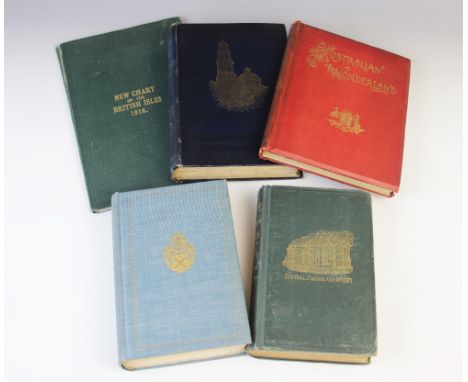
Lindestrom (P), GEOGRAPHIA AMERICAE WITH AN ACCOUNT OF THE DELAWARE INDIANS, Based On Surveys And Notes Made In 1654-1656, first edition, blue buckram boards, gilt embossed decoration to cover, gilt title to spine, inscribed to front free endpaper, monochrome plates and facsimile documents throughout, four fold-out maps, The Swedish Colonial Society, Philadelphia 1925, with Charnay (D), THE ANCIENT CITIES OF THE NEW WORLD. BEING TRAVELS AND EXPLORATIONS IN MEXICO AND CENTRAL AMERICA FROM 1857-1882, first edition, gilt embossed illustration to cover, gilt title and decoration to spine, black endpapers, applied bookplate, engraved frontispiece, engraved illustrations and plates throughout (p512 'Terra-cotta mask found at mitla' not present), fold-out map, Chapman and Hall Limited, London 1887, Sheahan (J.W.) and Upton (G.P.), THE GREAT CONFLAGRATION. CHICAGO: ITS PAST, PRESENT AND FUTURE, double engraved frontispiece, engraved plates and illustrations throughout, fold-out map, Union Publishing Co, Chicago 1872, RICHARDSON'S NEW CHART OF THE BRITISH ISLES 1916, and Cook (S), THE JENOLAN CAVES: AN EXCURSION IN AUSTRALIAN WONDERLAND, Eyre & Spottiswoode, London 1889 (5)


° Tolkien, John Ronald Reuel (1892-1973) - The Hobbit or There and Back Again, 1st edition, 1st impression, with 1st impression dust jacket, with the word ‘’Dodgeson’’ hand corrected, with an ink mark through the ‘’e’’, the unclipped front flap with price of 7s 6d, 8vo, frontispiece and 9 plates or illustrations (all but one full page), endpapers with Thor’s map and a map of Wilderland (printed in red and black) by the author, publishers green cloth, lettered and decorated in dark blue, George Allen & Unwin Ltd., London, 1937Note: The Hobbit was first published on September 21st, 1937, with a print run of 1500 copies that was sold out by December 15th of that
![° Hastings interest - [Moss, William George] - The History and Antiquities of the Town and Port of Hastings, 1st edition, 8v](https://cdn.globalauctionplatform.com/d824c333-8502-4c45-b4b8-adb9009de2ac/2d50507c-f0c4-4a00-8ce0-adb900a29939/468x382.jpg)
° Hastings interest - [Moss, William George] - The History and Antiquities of the Town and Port of Hastings, 1st edition, 8vo, calf gilt, with folding map and 19 plates, London, 1824; ‘’An inhabitant’’ - The Hastings Guide, 3rd edition, 8vo, card boards, 4 plates, spine poorly repaired, James Barry, London, 1804 and Bannister, H.O and Turner, J (editors) - Picturesque Hastings: Souvenir of the Conference of the National Union of Teachers, Easter, 1st edition, red morocco, London, 1908 (3)


![° [Hatton, Edward] A New View of London: or, an Ample Account of that City...containing a more particular description thereo](https://cdn.globalauctionplatform.com/d824c333-8502-4c45-b4b8-adb9009de2ac/7504a409-53c1-4672-9d35-adb900a15545/468x382.jpg)
° [Hatton, Edward] A New View of London: or, an Ample Account of that City...containing a more particular description thereof than ... of any other city in the world ... 2 vols, with a large folded map, frontis., 2 folded plates of armorials, a folded table and a text plan, contemp. panelled calf. 1708

° Hermannides, Rutgerus. Britannia Magna ... Geographico-Historica Descriptio.pictorial engraved and printed titles, 18 folded plans (only - of 32); old vellum, ms. spine title, 12mo. Amsterdam, 1661; sold with: Paterson, Daniel. A New and Accurate Description of all the Direct and Principal Cross Roads ... 9th edition. d-page map; contemp. half calf and marbled boards, 1792


![° [Cromwell, Thomas] - Excursions in the County of Kent, qto, large paper edition, red morocco gilt, folding map and 44 plat](https://cdn.globalauctionplatform.com/d824c333-8502-4c45-b4b8-adb9009de2ac/b6929d32-bd48-4c09-8332-adb900a2ccb5/468x382.jpg)

A WWII Silk Escape Map Sheet A India (Part of) and Burma (North West) Sheet B, Burma (North East), Siam (Thailand) (North), French Indo-China (Part of) and China (Part of). Second World War silk maps were created by MI9 for agents in foreign countries if they need to get out quick, and were then later issued to Air Crews for the same reason


![Poole Pottery, Cities in Sketch, one plate 27.5cm wide, four plates 21cm wide and six map plates [11]](https://cdn.globalauctionplatform.com/a6ba38c7-3c37-4f74-b320-ad97010adf93/dcee22c9-b02e-47c8-82e5-adba010bee73/468x382.jpg)


BOOKS ON WALES, NORTH WALES & OTHERS - a quantity, titles include 'Archaeologia Cambreusis' the Journal of the Cambrian Archaeological Association Volume III, 3rd Series J Russell Smith London 1857, 'History of Friars School' by Henry Barber and Henry Lewis, Jarvis & Foster Bangor 1901, 'Thorough Guide Series North Wales Part 1', 4th Edition revised Dulau & Co London 1892, 'A Short History of Wales' by Owen Edwards, T Fisher Unwin London 1901, stuck in letter from the author to the interior February 23 1902, 'Jenkinson's Practical Guide to North Wales', 3rd Edition with map and other maps, Edward Stanford London 1883, 'Murray's Handbook North Wales', 5th Edition revised, John Murray London 1885, 'The Old Churches of Arllechwedd' by Herbert L North, Jarvis & Foster Bangor 1906, hand cut pages, 'Views in North Wales from original drawings' by T L Rowbotham compiled by The Rev W J Loftie, Marcus Ward & Co London 1875, 'The Old Churches of Snowdonia' by H Harold Hughes, Jarvis & Foster Bangor 1924, hand cut pages, 'Beautiful North Wales Fifty Photographs Reproduced in Carbogravure with short descriptions', forward by Clement K Shorter, Photocrom Company Ltd London, 'The New Pictorial Atlas of the World', Odhams Press Ltd London and 'Lady Charlotte Guest's Mabinogion' from the Welsh of the Llyfr Coch O Hergest, translated with notes by Lady Charlotte Guest, Bernard Quaritch London 1877


-
109198 item(s)/page