

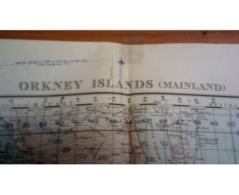
Historically Important Original D-Day (Normandy) and Other Maps, one from 2 July 44 showing German Defensive positions in great detail around Carpiquet and Buron south to Marcelet. 1:25,000, defence overprint with key to rear. This is a map we have never seen before and provides a detailed picture of the Defences, down to mg nests for the 12SS at this time (. c.65 cms x c.55cms). Also cut down map, hand coloured of the area around Epron etc, defence key at rear ( c.18cms x 10cms), Another Defence overprint map of area east of the Caen canal from Gorineville sur Merville down to Sonnerville, key to rear and Army Signals stamp. Interesting map of Caen dated March 1944 1:25,000, Also Defence overprint of Delmenhorst 1:25,000 April 1945 with some defences shown and key to rear, c.65 x 55cms). Note another map with hand annotations for Bremen March 1945. Another c.30 geographic maps either of France or Germany for the same period. Note with this lot is "The History of the 2nd Battalion the Lincolnshire Regiment in North-West Europe 6th June 1944 and After" c.50pp., privately published and rare. See lot above for the rest of the Collection) (c35)
We found 109182 price guide item(s) matching your search
There are 109182 lots that match your search criteria. Subscribe now to get instant access to the full price guide service.
Click here to subscribe- List
- Grid
-
109182 item(s)/page


Militaria & Collectibles - various Guinness miniatures; three Vietnam zippo lighters inscribed DONG AP BIA 65-66, BONG SON 68-69, CAM RANH 72-73 inscribed to verso 'The human brain functions 24 hours a day give it a break and get mellow' dated 1968; Vietnam pocket map Triem DU'C'; four HM PRISON 20 units phone card; Russian military medal with ID papers c.1960, others QTY

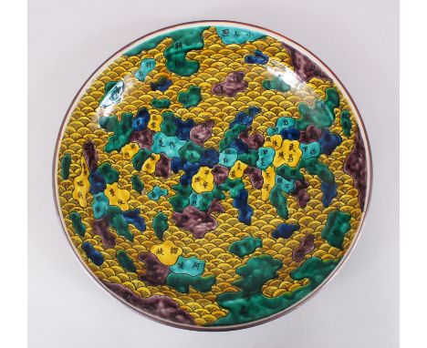
A VERY UNUSUAL JAPANESE MEIJI PERIOD IMARI ENAMEL MAP OF JAPAN PORCELAIN CHARGER, the dish forms a typical Imari style that depicts a map of Japan, the sea highlighted with yellow enamel and styled as waves, the regions of Japan highlighted in different shades of green, brown and yellow, the reverse is enamelled green with formal foliage scrolling, with a yellow centre and a stylized mark. 36.9cm diameter.


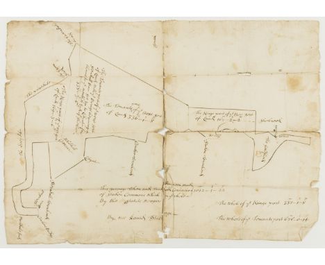
Derbyshire.- This Survaye Taken and True Division made of Staden Commons... By mee Daniel Stubinge, manuscript and pen and ink map on paper, long tears along folds, some browning and staining, Amsterdam watermark, 315 x 415mm., [?late 17th century]; and another, a late 18th/early 19th century pen and ink and manuscript map of Allsopp in the Dale in Derbyshire owned by Francis Beresford, v.s., v.d. (2).


Stevenson (Robert Louis) Kidnapped, first edition, second issue with 'pleasure' to p.40, line 11, folding map frontispiece, contemporary ink ownership inscription, scattered foxing, original red cloth, spine slightly faded, splash marks to covers, corners bumped, 1886; and a defective Child's Garden of Verses, 8vo (2)
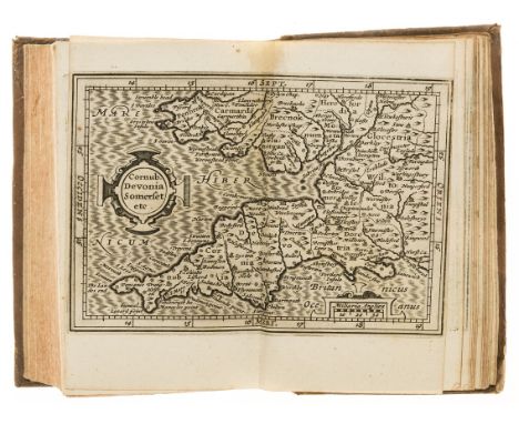
Britain.- Camden (William) Britannia, sive florentiss. Regnorum Angliae, Scotiae, Hiberniae..., woodcut device on title, 19 double-page engraved maps mounted on stubs at end, a few with border slightly shaved at fore-edge, some light water-staining, final map stained and bound upside down (partly laid down), title soiled, R6 torn and repaired, S3 defective at lower outer corner not affecting text, contemporary sprinkled calf, old paper manuscript label, rubbed, small worn patch to spine, Amsterdam, William Blaeu, 1639 § Cary (John, publisher) Cary's New Map of England and Wales with Part of Scotland, second edition, engraved title, hand-coloured general map and 79 sheets (numbered 1-81), mostly engraved maps hand-coloured in outline but including dedication, key & scale as part of sheets, no sheets numbered 62 or 80 as issued (presumably unnumbered title and general map), 101pp. "List of Places" at end, a few pencil annotations, some offsetting, contemporary mottled calf, gilt, spine gilt, worn patches to upper cover, John Cary, 1794 § Paterson (Daniel) A New and Accurate Description of all the...Roads in England and Wales, tenth edition, double-page engraved map, old pencil sketches to endpapers, later tree calf, gilt, by Zaehnsdorf, spine gilt, worn patches to covers, 1794, v.s. (3)
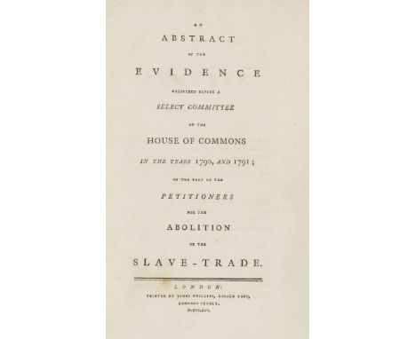
NO RESERVE Africa.- Slavery.- Abstract (An) of the Evidence delivered before a Select Committee of the House of Commons in the years 1790, and 1791; on the part of the Petitioners for the Abolition of the Slave-Trade, xxvi & 155pp., first edition, with folding engraved map of west coast of Africa but lacking folding plan of slave ship, very occasional spotting or soiling, disbound, [Sabin 81745], James Phillips, 1791 § [Harrison (George)] Some Remarks on a Communication from Wm. Roscoe to the Duke of Gloucester...as stated in...the Third Report of the African Institution, 11pp., first edition, title browned, some spotting, final leaf laid down, disbound, George Ellerton, 1810 § Park (Mungo) Travels in the Interior Districts of Africa, second edition, half-title, stipple-engraved portrait, 3 folding engraved maps (one with routes supplied in red and blue) and 5 plates (2 botanical and folding), with the 2 engraved leaves of musical notation (not always found) bound with Postscript leaf following title, list of subscribers, light foxing and soiling, one plate a little damp-stained in corner, one map with tear repaired, contemporary half sheep, roan label, rubbed, split to lower joint, corners repaired, Printed by Bulmer and Co. for the Author, 1799; and a fifth edition of the last, 8vo & 4to (4)⁂ The African Institution was established in 1807 following the abolition of the slave trade in Britain, with the aim of creating a haven for freed slaves in Freetown, Sierra Leone. The Duke of Gloucester, nephew of George III, was the first President, and William Wilberforce one of its leaders. The abolitionist William Roscoe of Liverpool had proposed that trade with Africa would be the greatest benefit to promoting civilisation in Freetown but George Harrison advises caution. COPAC lists 3 copies of his pamphlet (BL, Newcastle University, and the Society of Friends).

New Zealand.- Hochstetter (Dr. Ferdinand von) New Zealand: Its Physical Geography, Geology and Natural History with special reference to...Auckland and Nelson, first English edition, with dedication to Queen Victoria dated 1868 tipped in following title (not mentioned in Hocken), 7 chromolithographed and 10 wood-engraved plates, 2 folding maps hand-coloured in outline, wood-engraved illustrations, tables, one folding, tissue guards, foxed, original blind-stamped cloth with gilt pictorial vignette in oval panel on upper cover, Stuttgart, 1867 § Cruise (Richard A.) Journal of a Ten Months' Residence in New Zealand, first edition, hand-coloured aquatint frontispiece, errata slip tipped in, light foxing, especially to title and final leaf, original boards, uncut, spine a little worn and label rubbed, 1823 § Petre (Hon. Henry William) An Account of the Settlements of the New Zealand Colony..., second edition, half-title, folding engraved map, 2 engraved plates, with final blank and 4pp. advertisements at end, original limp blind-stamped cloth, lightly damp-stained, spine faded, 1841 § New Zealand War of 1860 (The); An Inquiry into its Origin and Justice, together with some remarks on the Land Question , in relation to the Natives, copied...from the "Colonial Intelligencer"; the organ of the Aborigines' Protection Society, 52pp., title and final leaf lightly soiled, vertical crease, modern morocco, W.Tweedie, [1861], all but the last rubbed, [Hocken pp.249, 39, 98 & 211]; and 2 others, New Zealand, 4to & 8vo (6)⁂ The first contains some additional material to the German edition of 1863, being altered for a British audience.

NO RESERVE South East Asia.- Wallace (Alfred Russel) The Malay Archipelago, 2 vol., second edition, half-titles, one folding colour map only (of 2, lacking Physical Map in vol.1), wood-engraved plates, maps and illustrations, advertisement leaf at end of vol.2, occasional spotting or soiling, hinges of vol.2 weak, endpapers of vol.1 renewed, original pictorial green cloth, gilt, a little rubbed and marked, slight staining to spines, 8vo, 1869.
-
109182 item(s)/page