We found 109182 price guide item(s) matching your search
There are 109182 lots that match your search criteria. Subscribe now to get instant access to the full price guide service.
Click here to subscribe- List
- Grid
-
109182 item(s)/page


Lot 97
PRATT A. E. To the Snows of Tibet Through China. Illus. & fldg. map. Very worn orig. blue cloth, much internal damp stng., etc., poor & ex lib. 1st ed., n.d., 1892; also H. A. Franck, Wandering In China, illus. & fldg. map, rebound cloth, 1924 & J. Morris, Living With Lepchas, illus., cloth, 1938. (3).

Lot 209
KEARSLEY G. (Pubs). The Gentleman's Guide in His Tour Through France with a Correct Map of All the Routes of the Public Carriages, the Expence of Travelling ... etc. Fldg. eng. map. 12mo. Dark half calf, edge rubbing. 10th ed., 1788; also John Scott, Paris Revisited in 1815 ... including A Walk Over the Field of Battle at Waterloo, half calf, 1816. (2).


Lot 706
Speed, John. 17th-century map of The West Riding of Yorkshire, hand-coloured copper engraving on laid/chain-lined paper bearing manufacturer's watermark, published by Sudbury & Humble. Featuring inset plan of York and heraldic shields. Framed & glazed recto & verso (both sides visible), 39cm by 52cm. Good, clean, bright, with some faint creasing and very slight wear at upper-right

Lot 715
R. W. Seale. Middlesex, hand-coloured copper engraving, London: Bowles & Sayer, c.1760, map featuring decorative cartouche and coats-of-arms for all the Free Companies of London. Unframed, 55.5cm by 74.5cm (sheet). Well-preserved, clean, bright; some wear to edges of sheet (not affecting the engraving); housed in protective clear wrappers


Lot 705
George Philip & Son, collection of colour maps, sectional and linen-backed, housed within two wooden slipcases bearing publisher labels, 'Comparative Series of Wall Atlases'. Comprising eight maps of North America (numbered 1, 2, 3, 4, 5, 7, 8) showing climate, population, communications and so on (plus another duplicate of No. 1, which is damaged); Near East; Far East; Asia (numbered 1 to 8) showing climate, population, commercial development and so on. 18 maps in total. Generally well-preserved and vibrant, occasional splitting along fold-lines; slipcases worn as found. Each map measuring approx. 113cm by 87cm


Lot 718
Speed, John (1552-1629). 17th-century map of Staffordshire, hand-coloured copper engraving on laid/chain-lined paper, featuring inset views of Lichfield and Stafford, Bassett & Chiswell, English text to verso. 39cm by 52cm. Framed & glazed to recto and verso (both sides visible). Well-preserved, clean, bright; some discolouration to central fold at verso

Lot 766
Broadside. The Universal Prophetic Almanack! Bristol: Sold by J. Wansbrough, 1841. Featuring woodcut illustration of storms, war, fire and death. 55cm by 44cm. Generally very well-preserved given the delicate nature of the fine paper, fold-lines, creasing, a few marks. Together with The Pictorial Map of Palestine, London: James Nisbet & Co., no date, colour wood-engraving by Edmund Evans, 52cm by 74cm, fold-lines, some wear, old paper repair verso (2)
Lot 679
Collection of 12 miscellaneous leather-bound books, to include Lectures on the Materia Medica, by William Cullen, second edition, Dublin: W. & H. Whitestone, 1781; Views in Rome, engraved by W. B. Cooke, London: Charles Tilt, 1840; New Book of Roads, third edition, London: W. Owen, 1782, with folding map; The History of Derby, by W. Hutton, London: Nichols, 1817; The Naval and Military History of the Wars of England, in two volumes, by Thomas Mante, London: Printed for the Author, [1795], and others, condition varied, as found (12)


Lot 457
JAMES STANIER CLARKE & JOHN M'ARTHUR: THE LIFE AND SERVICES OF HORATIO VISCOUNT NELSON...FROM HIS LORDSHIP'S MANUSCRIPTS, London, Fisher, Son & Co, [1840] 3 vols, added engraved vignette titles, 37 plates including folding map, old half calf marbled boards, rebacked, morocco gilt spine labels, new end papers (3)
![[THOMAS KITSON CROMWELL]: 3 titles: EXCURSIONS IN THE COUNTY OF ESSEX..., London, Longman, Hurst, Rees, Orme & Brown, 181](https://cdn.globalauctionplatform.com/8f4f73d8-9ab6-4e6a-a07b-ac8600bf066a/ca108c02-59f2-4705-a842-ac870144dc27/468x382.jpg)
Lot 551
[THOMAS KITSON CROMWELL]: 3 titles: EXCURSIONS IN THE COUNTY OF ESSEX..., London, Longman, Hurst, Rees, Orme & Brown, 1818, 2 vols, engraved titles, folding map, folding plan and all plates as listed + 2 additional plates not listed; EXCURSIONS IN THE COUNTY OF SUFFOLK..., London, Longman, Hurst, Rees, Orme & Brown, 1818, 2 vols, engraved titles, folding map, folding plan and plates as list; EXCURSIONS IN THE COUNTY OF NORFOLK..., London, Longman, Hurst, Rees, Orme & Brown, 1818, 2 vols, engraved titles, folding map and folding plan but lacking 2 plates in vol 1, Bracondale & Burnham Thorpe, 12mo, uniform decorative crimson morocco gilt, all edges gilt, armorial book plates of S Ratcliff + ANON: THE LIVES OF EMINENT AND REMARKABLE CHARACTERS BORN OR NON-RESIDENT IN THE COUNTIES OF ESSEX, SUFFOLK AND NORFOLK, London, Longman, Hurst, Rees, Orme & Brown, 1820, 1st edition, 68 engraved ports, contemporary decorative grained crimson morocco gilt, spine gilt in compartments, all edges gilt (7)
![[RICHARD OF HOLDINGHAM]: THE HEREFORD WORLD MAP, MAPPA MUNDI, London, Folio Society, 2010, (1000) numbered (22), the large ca](https://cdn.globalauctionplatform.com/8f4f73d8-9ab6-4e6a-a07b-ac8600bf066a/98a51c65-6939-4506-9f06-ac870108aae3/468x382.jpg)
Lot 137
[RICHARD OF HOLDINGHAM]: THE HEREFORD WORLD MAP, MAPPA MUNDI, London, Folio Society, 2010, (1000) numbered (22), the large canvas backed coloured map housed in original large oak box, together with the two companion volumes, each 4to, original cloth gilt, slip-cases, as new, from the collection of Derek Cottam (3)

![THOMAS READ: NORFOLK, engraved hand coloured map [1744], approx 150 x 195mm, framed and glazed](https://cdn.globalauctionplatform.com/8f4f73d8-9ab6-4e6a-a07b-ac8600bf066a/231ca978-6776-4a56-881d-ac8a00a25358/468x382.jpg)


Lot 583
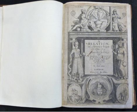
GEORGE SANDYS: A RELATION OF A JOURNEY BEGUN AN DOM 1610 FOURE BOOKES CONTAINING A DESCRIPTION OF THE TURKISH EMPIRE OF AEGYPT, OF THE HOLY LAND, OF THE REMOTE PARTS OF ITALY AND ISLANDES ADIOYNING, London for Ro Allot [printed by Thomas Coates], 1652, 3rd edition, engraved architectural title page and some leaves re-margined, folding map and folding prospect (this bound in after the map), both with repairs and reinforcements, 47 text engravings, page 199 small part loss at bottom right corner just affecting some text, page 271-272 small rust hole, page 293, 294 paper flaw, 4to, old calf rebacked, morocco gilt spine label, book plate of Sir Robert Walpole
![JOHN SPEED: NORFOLK..., engraved hand coloured map [1627], English text verso, approx 380 x 510mm, double glazed framed](https://cdn.globalauctionplatform.com/8f4f73d8-9ab6-4e6a-a07b-ac8600bf066a/38f527ab-eef4-4162-a2db-ac8a00a25687/468x382.jpg)


Lot 533
JOHN BRITTON & E W BRAYLEY: A TOPOGRAPHICAL AND HISTORICAL DESCRIPTION OF THE COUNTY OF NORFOLK..., London for Sherwood Neely & Jones [1812], engraved folding frontis map and 20 plates as called for, old blind stamp calf, rebacked morocco gilt spine label, armorial book plate of Hildyard on front paste down

Lot 105
Unusual early 20th Century base metal combination open-face pocket watch and map-reading gauge, the white Roman dial with subsidiary at VI, enclosing anonymous top-wound movement, the detachable rear inscribed Registered No. 44851 converting Centimetres to Kilometres and Inches to Miles or Verstes, internally stamped 807858, the winding crown inset with compass, 48mm diameter Condition: Dial in good condition, movment takes wind but balance wheel does not run freeely, may require attention and is sold as seen wiothout guarantee, minor staining and one blemish to rear dial -**General condition consistent with age.
Lot 691
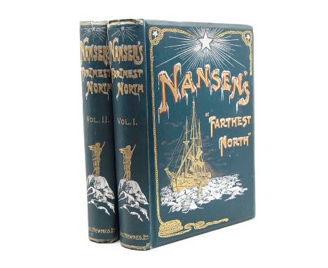
Nansen, Fridtjof. Farthest North, in two volumes, London: George Newnes, 1898. Chromolithographic plate, folding map, and numerous illustrations within the text. Octavo, publisher's gilt pictorial cloth. Contents generally very good, clean, bright; occasional light marks, offsetting and spots; map with two tears; bindings with wear to extremities and splitting to upper joint of first volume (2)


Lot 1937
Ortelius,H.Ortelius,H. Ortelius Redivivus Et Continuatus, Oder der ungarischen Kriegs-E Ortelius,H. Ortelius,H. Ortelius Redivivus Et Continuatus, Oder der ungarischen Kriegs-Empörungen, historische Beschreibung,... zwischen theils Christlichen Ungarischen Königen und dem Hochlöbl. Ertz-Hauß Oesterreich, 2 in 1 Bd. Ffm., D.Fievet für P.Fürst in Nbg. 1665. Fol. Mit gest. Tit., 1 gefalt. Kupferstichkte., 48 (statt 50) gest. Portr. u. 54 Taf. mit 55 Ansichten. 6 Bl., 431 S., 6 Bl.; 5 Bl., 362 S., 10 Bl. Prgt. d. Zt. mit Schließbändern. (Ob. Rckn. läd., best. u. tls. etw. fl.). VD17 23:323414S. Nebehay-W. 464 (mit 40 Portr.-Taf.). Lipperheide 891. Bircher B 9595-96. Sturminger 300. Rózsa 7 und 42 a. - Dritte u. umfangreichste Ausg. der Geschichts- u. Landesbeschreibung mit der Karte 'Totius Regni Hungariae'. - 2 Portr. fehlen. S. 51 mit ausgebesserter Randfehlstelle, Innenspiegel tls. gelockert, rechter Teil der gefalt. Kte. gelöst, tls. gering gebräunt. - 3rd edition. With engraved title, 1 folded copper engraved map, 48 (of 50) engraved portraits and 54 plates with 55 views. Contemporary vellum (Upper spine damaged, bumped and partly somewhat stained). Page 51 with repaired damage, pastedowns loosened, right part of the folding map loosened, partly slightly browned.
Lot 1831
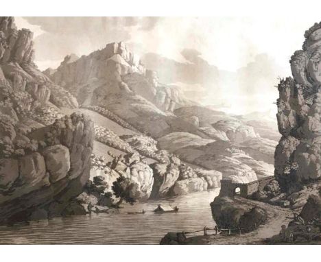
Beaumont,(J.F.)A.de.Beaumont,(J.F.)A.de. Travels through the Rhaetian Alps, in the Year Beaumont,(J.F.)A.de. Beaumont,(J.F.)A.de. Travels through the Rhaetian Alps, in the YearMDCCLXXXVI. From Italy to Germany, through Tyrol. London, Clarke etc. 1792. Gr.Fol. VIII, 82 S., 1 Bl., 10 Aquatinta-Taf. in Braundruck (Sepia) v. C. Apostool nach Beaumont (8) u. H. Meyer, 1 gest. Kte. Hldr. um 1900. (Kaum berieb., gering best., kl. Schabstellen). Abbey 50; Cox I, 161; Dreyer 42; Nebehay/W. 83; W'ber 329; nicht bei Colas, Hiler u. Lipperh. - Erste Ausgabe. - Die prächtigen Tafeln mit acht malerischen Ansichten u. zwei Kostümdarstellungen. Die Karte von Beaumont zeigt 'places connected with the Route from Venice to Fussen in Swabia'. - Unkoloriertes Expl. Die Kte. mit geringem Abklatsch auf Seite 1. Titel etwas angestaubt, die Ränder leicht gebräunt. S. III/IV mit unterem repariertem Randeinriss (ca. 10 cm im w. Rand). Im übrigen vereinz. etwas stockfl., die Tafeln meist jedoch bis zum Plattenrand sauber und wohlerhalten. Einige oberste u. wenige seitl. w. Ränder wellig bzw. auch gebräunt oder angestaubt u. mit wenigen minimalen reparierten Einrissen (le. Bl. und Tafeln gegen Ende). Durchgehend ein oberes Eselsohr angeknickt und geglättet, bei den ersten beiden Bll. mit gegl. Faltspur. Insgesamt schönes breitrandiges Exemplar. - First edition. With 10 aquatint plates and 1 engraved map. Half leather around 1900, slightly rubbed and bumped. Partly slightly browned, occasionally somewhat foxing, p. III/IV with repaired tear.

Lot 2360
Geknüpfte Landkarte Süd-Persien, Kirman, um 1900 182 x 151 cm Originelle Knüpfarbeit mit der Darstellung einer Landkarte des antiken Grossreichs Persien mit den verschiedenen Bezeichungen der Städte. Die Bordüre zeigt alternierend Herrscherportraits mit Kalligraphie-Medaillons. Minim. rep. und rest. Provenienz: Aus einer alten süddeutschen Privatsammlung. A CURIOUS PICTORIAL RUG ILLUSTRATING A MAP OF THE ANTIQUE PERSIAN EMPIRE WITH INSCRIBED NAMES OF THE VARIOUS CITIES, Southern Persia, Kirman, ca. 1900 - Provenance: Old South German private collection - Small areas of repair and restoring.

Lot 1918
TheatreTheatre nouveau des guerres presentes aux Pais Bas autrichiens, francois et holl Theatre Theatre nouveau des guerres presentes aux Pais Bas autrichiens, francois et hollandois (zweisprachig franz.-holl.). Deventer, Jean de Lat & Almelo, Jacob Keyser 1745. Schm.Gr.8°. Mit (wdh.) gest. Titelvign. u. 38 gefalt. kolor. Kupferstichkarten. 3 Bl. Beschäd. Hldr. d. Zt. (Rckn. mit Fehlst.). Koeman Lat 6. - Atlas mit detaillierten Karten der Provinzen der südlichen Niederlande. - Tls. leicht fleckig u. ger. knickfaltig, Karten verso hs. num., erste (Übersichts)-Karte mit Falzeinriß, hs. Besitzverm. auf Innendeckel (Le Comte Goyon de Beaufort). - Atlas with detailed maps of the provinces of the southern Netherlands. With engraved title vignette and 38 folded and coloured copper engraved maps. Damaged contemporary half leather. Partly slightly stained and wrinkled, 1 map with tear.

Lot 1857
Sanson,N.Sanson,N. Sammelatlas mit 79 (62 dplblgr.) kolor. Kupferkarten, 2 kolor., gest Sanson,N. Sanson,N. Sammelatlas mit 79 (62 dplblgr.) kolor. Kupferkarten, 2 kolor., gest. Tabellen u. 12 blgr. numer. gest. Tabellen. Amsterdam, P.Mortier u. Paris H.Jaillot 1678-1696. Gr.Fol. - Vorgebunden: +Ders. Introduction+ a la Geographie, ou sont la Geographie astronomique... Amsterdam, P.Mortier o.J. Mit kolor. gest. Titelvign. 1 Bl., 16 S. Läd. Ldr. d. Zt. mit Blindpräg. Enthält eine Weltkarte (Mappe Monde geo-hydrographique), 5 Erdteilkarten (Europa, Asien, Afrika, Nord- u. Südamerika), britische Inseln u. Ärmelkanal (4 Ktn.), Skandinavien u. Russland (4 Karten), Frankreich (24 Karten u. 2 Tabellen, dabei Stadtplan von Paris von de Fer) u. Deutschland mit Österreich u. Böhmen (41 Karten, mit Plan der Stadt Wien). - Weltkarte oberer u. unterer Rand feuchtigkeitsrandig, Bug unten gerissen u. Einriß im unt. Rand; Kte. Nordamerika im Bug tls. gerissen, stellenw.etw. gebräunt u. Randeinr. unterlegt; Kte. Irland gr. Einriß unterlegt; Carte de Moscovie... rechter Rand knapp beschnitten, randrissig u. knittrig; Kte. Cours du Danube von P.Coronelli mit größ. Fehlst. des rechten Kartenteils; sonst tls. knittrig, vereinz. Randbeschäd., tls. angest., tls. etw. fleckig, tls. Rand feuchtigkeitsrandig. - Collection of 79 coloured copper maps, 2 coloured tables and 12 numbered and engraved tables, bound in 1 volume. Bound with: Introduction a la Geographie, ou sont la Geographie astronomique... Amsterdam, P.Mortier (without date). With coloured engraved vignette on the title. Damaged contemporary leather. Partly waterstained, with tears (partly repaired), partly somewhat wrinkled, map 'Cours du Danube' with damage, partly dusty, in places somewhat stained.

Lot 32
Christo (American, 1935-2020)The Mastaba of Abu Dhabi (project for United Arab Emirates), 2015 signed twice Christo (on the reverse)pastel, pen and printed map on paper laid on postcard10.3 x 14.8 cm.4 1/16 x 5 13/16 in.Footnotes:ProvenanceRoyal College of Art, Stewarts RCA Secret, LondonAcquired directly from the above by the present owner in 2015This lot is subject to the following lot symbols: ARAR Goods subject to Artists Resale Right Additional Premium.For further information on this lot please visit Bonhams.com


Lot 1136
Genealogy: Esterick (M.) Heirs & Graces The Claim to the Dukedom of Leinster, L. 1981, illus.; Gaughan (J. Anthony) The Knights of Glin - A Geraldine Family, Naas 1978, illus; Iske (Basil) The Green Cockatrice, D. 1978; Gregory Vere (R.T.) The House of Gregory, D. 1943; Enniskillen (Countess of) Florence Court My Irish Home, Monaghan 1972; The Clans of Ireland, Their Battles, Chiefs, and Princes, D. n.d. fold. map; & 3 others. As a lot. (9)
Lot 690
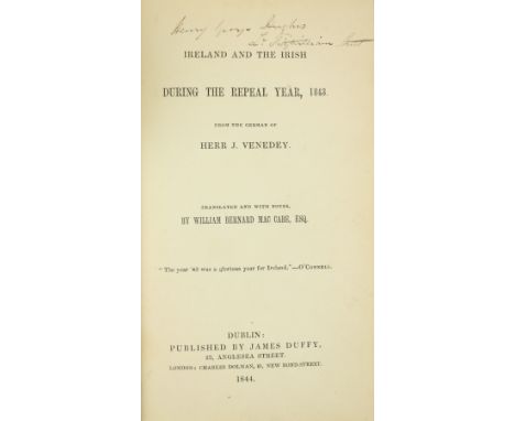
Venedey (Herr J.) Ireland and the Irish During the Repeal Year 1843. Trans. by Wm. B. Mc Cabe, 8vo D. 1844. First Edn., cloth; Trevelyan (C.E.) The Irish Crisis, 12mo L. 1848. First Edn. in Bk. Form, Trevelyan was infamous during The Great Famine in Ireland, 1845 - 1849; Donovan (Daniel) Sketches in Carbery, Co. Cork, D. 1876 First Edn., cloth; Croker (T. Crofton) Killarney Legends, L. n.d., cold. fold. map, illus., decor. cloth. (4)

Lot 136
Maps: England & Wales: Faden (W.) A Map of England, Wales & Scotland, describing all the Direct and Principal Cross Roads in Great Britain… L. 1801, lg. fold. linen backed map, 76cms x 62cms (30" x 24 1/2"), fully hd. cold., slip case; Stanford (Ed.) Railway Map of the British Isles and Part of France, by B.R. Davies. L. c. 1880. Lg. folding map on linen, bright hand colouring, 97cms x 81cms (38" x 32") approx. in slip case; Stanford's Portable Map of England and Wales with The Railways… L. c. 1881, fold. linen backed map, fully hand cold, 83cms x 76cms (32 1/2" x 30"), fold. cloth covers. As maps, w.a.f. (3)

Lot 1080
Map Presented to an Irish Count, 1962An attractive coloured Map, 42cms x 61cms, of a house, garden and environs (unidentified) with covering note to the effect that it was presented on 9 November 1962 by George O'Donnell to Count and Countess Donal O'Kelly de Gallagh "as a small memento of a great occasion in their lives," The recipient has not been identified, as there appears to have been no member of this family called Donal in modern times. Its most famous member was the diplomat Gerald Edward O'Kelly de Gallagh et Tycooly (1890 - 1968), whose ancestor had been created a Count of the Holy Roman Empire in 1767. As a m/ss, w.a.f. (1)

Lot 135
Maps of France: Andriveau (J.) Carte Generale des Routes de France, Paris 1840, New Edn., hd. cold. fold. linen backed map, approx. 64cms x 80cms (25" x 31 1/2") in slip case; de Simencourt - Carte Itineraire Complete de La France, Paris 1846, fold. linen backed map, hd. cold. in outline, approx. 66cms x 96cms (26" x 38"), in slip case; Dumont (A.) Carte des Travaux Publics en France, .... des Chemins de Fer et l'ensemble des Voies Navigables,... Paris (E. Andrievau - Goujon) 1868. Lg. linen backed map, hd. cold., approx. 67cms x 82cms (26 1/2" x 32 1/2"), slipcase; Coutaut (E.) Carte Routiere et Vinicole Department de la Gironde, Bordeaux 1876. lg. hd. cold. linen map, approx. 99cms x 77cms (39" x 30 1/2"), cloth., together 4 maps, as a coll., w.a.f. Good. (4)
-
109182 item(s)/page