

Major (Richard Henry). Memoir on a Mappemonde by Leonardo Da Vinci, being the earliest map hitherto known containing the name of America..., 1865, monochrome folding map to rear, inscribed by the author to front endpaper, facsimile letter by B.B. Woodward to front, some minor toning, original blue cloth, boards and spine slightly rubbed, large 4to, together with Steer (D.M.), The Blockade of Brest by the Royal Navy, 1793-1805, a privately printed thesis, Liverpool, 1971, tipped in black and white illustrations, original black cloth, 4to, and Obreg¢n (Mauricio), The Columbus Papers, The Barcelona Letter of 1493, The Landfall Controversy and the Indian Guides, facsimile edition, 1991, colour and black and white illustrations, original red quarter morocco in slipcase, 4to, plus other exploration and cartography reference and related, mostly original cloth, some in dust jackets, G/VG, 8vo/4to Provenance: From the Library of Cecil H. Clough (1930-2017). (6 shelves)
We found 109198 price guide item(s) matching your search
There are 109198 lots that match your search criteria. Subscribe now to get instant access to the full price guide service.
Click here to subscribe- List
- Grid
-
109198 item(s)/page
Lewis (William, publisher). Lewis's New Traveller's Guide, or a pocket edition of the English counties, containing all the direct & cross roads in England & Wales, [1819], hand coloured engraved frontispiece of a map of England & Wales, calligraphic title page with a black & white engraved vignette of a coach and postillions, preface (dated 1819), contents list, list of mail coaches and cost of postage, forty-two (complete as list) engraved maps with contemporary hand colouring, including one folding (Yorkshire), each map with a page of descriptive text, upper hinge and joint broken and spine detached, rear hinge cracked, contemporary quarter morocco gilt, heavily worn and frayed, 12mo, together with Hall (Sidney), A travelling county atlas: with all the coach and rail roads accurately laid down and coloured..., Chapman and Hall, 1845, title and contents, forty-six (complete as list) double page engraved maps with contemporary outline colouring, including four folding (Ireland, Wales, Scotland and Yorkshire), some spotting and dust soiling throughout, text block and hinges cracked, contemporary ownership signature to front endpaper, contemporary morocco 'envelope style' binding, gilt title to upper cover, some fraying with slight loss to spine, 8vo, with another copy similar but with text block split and contents shaken and loose, and binding heavily worn with spine lacking, 8vo, plus Stanford (Edward, publisher), Stanford's Geological Atlas of Great Britian, 1904, colour lithographic geological map of the Birtish Isles, folding geological table, thirty-three double page colour lithographic geological maps and thirty-two uncoloured lithographic plates of fossils, publisher's blue cloth gilt, some wear to extremities, 8vo, and a 1903 map volume of the Encylopedia Britannica containing numerous photolithographic British & foreign maps, contemporary half morocco, slight wear to extremities, folio The first described item:- Chubb CCCLXIV. The title page is undated but the preface has the date Oct. 16 1819. (5)

Luffman (John). A New Pocket Atlas and Geography of England and Wales, Illustrated with fifty-five Copper plates shewing all the Great Post Roads with the Towns & Villages situated thereon..., 2nd edition, published Lackington Allen & Co., 1806, engraved title, preface and code sheet, fifty-four circular county maps with descriptive text below and a double page engraved map of England & Wales (complete), all with contemporary hand colouring, slight spotting and staining to title page, one map (Northamptoshire) with long closed tear, very slight spotting, text block detached and split, contemporary half morocco, printed label to upper siding, boards detached, spine partially lacking, heavily worn and frayed, 8vo Scarce. Chubb CCCIX. (1)
Railways. A mixed collection of books, maps and photographs relating to railways, mostly 20th century, including MacDermot (E. T.), History of the Great Western Railway, 2 volumes (bound in three), 1927 - 1931, portrait frontispiece and numerous illustrations and maps throughout, contemporary cloth gilt, slight wear, 8vo (bound in 16s), together with Cruchley (G. F.), Railway map of England & Scotland, circa 1850, engraved map with contemporary outline colouring, sectionalised and laid on linen, inset map of the 'continuation of Scotland', some staining, 700 x 510 mm, book plate of Richard Wyatt Bagshawe, bound in contemporary cloth with printed label to upper board, with Bradshaw (George), Map & Section of the Railways of Great Britain..., 1845, large engraved map with contemporary outline colouring, sectionalised and laid on linen, inset map of the environs of London, numerous gradient profiles, some spotting, 1600 x 990 mm, contemporary cloth gilt, upper hinge crudely repaired with sellotape, heavily worn and frayed with spine partially detached, later ink manuscript date to upper cover, plus two volumes (1936 & 1939) of the Great Western Railway Magazine, a folding lithographic map of the Canadian Pacific railway and a large collection of approximately 300 20th century photographs all relating to railways, various sizes and condition (approx.300)
Thoroton (Robert). The Antiquities of Nottinghamshire, 1st edition, 1677, imprimatur leaf, title printed in red and black, eight plates of coats-of-arms, engraved slip with eight coats-of-arms, engraved double page map, 16 engraved plates and plans, most double page (one plate, Woolaton Hall with one fold rebacked), a occasional light soiling, a couple of small burn holes in text, armorial bookplate of George Follet to title verso, another bookplate of William Allesley, later panelled calf, rebacked, a little rubbed and scuffed, folio Wing T1063. (1)
![Tombleson (William). [Eighty Picturesque Views on the Thames and Medway], circa 1834, decorative title with near contemporary](https://cdn.globalauctionplatform.com/bdcc24b5-51e4-450c-9a38-a98300b3d03e/9140a0f2-2253-420f-938a-a985012cb8a3/468x382.jpg)
Tombleson (William). [Eighty Picturesque Views on the Thames and Medway], circa 1834, decorative title with near contemporary ownership signature, lacking printed title, dedication and preface, long engraved map on two conjoined sheets, folded concertina style, eighty (complete) uncoloured engraved views, each with tissue guard, marbled endpapers, contemporary half morocco gilt, slight wear to extremities, 4to The map is in the first state, lacking the village of Goring on Thames. (1)
[Brindley, James]. The History of Inland Navigations. Particularly those of the Duke of Bridgwater, in Lancashire and Cheshire; and the intended one promoted by Earl Gower and other Persons of Distinction in Staffordshire, Cheshire, and Derbyshire..., 1st edition, T. Lowndes, 1766, two folding engraved maps, first map neatly strengthened to folds at verso and close trimmed to ruled border at head, without half-title, gilt embossed morocco bookplate of Edward Hailstone to upper pastedown, early 19th century marbled boards with moderen maroon morocco spine, board edges rubbed, slim 8vo (1)
De Salis (Henry Rodolph). Bradshaw's Canals and Navigable Rivers of England and Wales. A Handbook of Inland Navigation for Manufacturers, Merchants, Traders, and Others..., 1918, folding colour lithograph map contained in rear pocket, manuscript ownership to front free endpaper, original green cloth gilt in bright condition, 8vo, together with A Chronology of Inland Navigation in Great Britain, 1897, with loosely inserted autograph letter signed from the author to Mr Bancroft of Ipswich Town Hall regarding travels around the navigations of the UK and his forthcoming book, original cloth gilt, 8vo, with Prothero (F.E. & Clark, W.A.), Cruising Club Manual. A New Oarsman's Guide to the Rivers and Canals of Great Britain and Ireland, 1st edition, 1896, folding lithograph map contained in rear pocket, original cloth, spine browned, frayed to extrem, 8vo, with Supplement to A New Oarsman'd Guide..., 1898, original printed wrappers, adhesive tape to lower left corner over upper cover, slim 8vo, plus other canal and inland waterway related, including Through the Kennet and Avon Canal by Motor Boat by Cyril Herbery Smith, 1st edition, 1929, inscribed by the author, and an ex-library set of History of the Manchester Ship Canal by Sir Bosdin Leech, 2 volumes, 1907 (18)
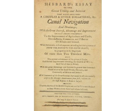
Hibbard (John). Hibbard's Essay of the Great Utility and Interest that might arise from a Circular & other Collateral, &c. Canal Navigation and Drainage, with the Great Interest, Advantage and Improvement locally arising therefrom to the Improvement of Agriculture and Cattle, Manufactures, Commerce, and Fisheries of Britain and Ireland. With Statements, at small expences, attending such being executed from the North to South Coasts, in proportion to its Magnitude of more than Two Thousand Miles. Also the present reducement of the prices of Grain. And further Improvement attending the Growth of Wheat, and use of Oats in Bread..., London: Printed for the Author, [1804], [2],43,[1],4pp., initial leaf facing title with few closed tear and lined to verso, last two lines of purchase information at foot of title crossed through, some dust-soiling and few marks, modern boards, slim 8vo The first edition was originally published in 1800. ESTC refers to an 1800 example with the presence of an illustration/manuscript map (ESTC N478108). The later edition in this lot includes a four page appendix 'The Author having published his thoughts....'. (1)
Phillips (John). A General History of Inland Navigation, Foreign and Domestic..., 4th edition, 1803, double-page engraved plate, some dampstaining and scattered spotting, edges untrimmed, endpapers renewed, original boards with 20th century cloth spine, preserving original printed title label, 8vo, together with A General History of Inland Navigation, Foreign and Domestic, new edition, corrected, with an addenda, which completes the history to 1792, I. & J. Taylor, 1793, four engraved plates, without folding map, some spotting and offsetting, edges untrimmed, 20th century ex-library brown quarter morocco, 4to, with Smiles (Samuel), Lives of the Engineers, 5 volumes, new & revised edition, 1874, engraved portrait frontispieces and wood engraved illustrations, contemporary calf, gilt decorated spines with morocco title labels, gilt embossed armorial to centre of upper boards, 8vo, with Dupin (Charles), The Commercial Power of Great Britain..., 2 volumes only (without atlas volume of plans), 1825, contemporary diced calf, gilt decorated spines with morocco title labels, 8vo, plus two other leather bound volumes relating to inland waterways by R.B. Dunwoody (11)
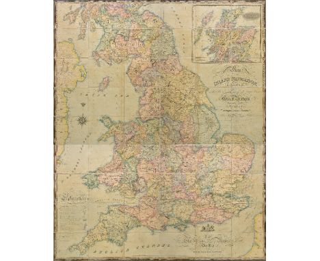
British Canal Map. Walker (John), Map of the Inland Navigation, Canals, and Rail Roads with the Situations of the various Mineral Productions throughout Great Britain, from actual surveys projected on the basis of the trigonometrical Survey made by order of The Honourable The Board of Ordnance..., published Richard Nichols, Wakefield, January 1st, 1830, very large engraved map with contemporary hand colouring, sectionalised and laid on linen, large calligraphic title and dedication, compass rose and table of explanation, inset map of Scotland, slight offsetting, marbled endpapers, 1920 x 1560 mm, contained in a contemporary calf gilt book box, worn at extremities, together with Priestley (Joseph), Historical account of the Navigable Rivers, Canals and Railways throughout Great Britain..., published Logman, Rees, orme, Broan and Green, 1831, title and deication, folding cross section bound at rear, contempoary half calf gilt, heavily worn and rubbed, 4to Published and intended to accompany Joseph Priestley's "Historical Account of the Navigable Rivers, Canals, and Railways, of Great Britain" (includied in the lot). The map contains a wealth of detail bringing together many aspects of the Industrial revolution, namely the mining industry and the canal and railway networks. (2)
Priestley (Joseph). Historical Account of the Navigable Rivers, Canals and Railways of Great Britain, as a Reference to Nichols, Priestley & Walker's New Map of Inland Navigation, derived from Original and Parliamentray Documents in the Possession of Joseph Priestley, Esq., 1831, double-page engraved map frontispiece and hand-coloured folding sectional plan at rear (slight offsetting), ink name stamp to front free endpaper, edges untrimmed, original cloth, printed paper title label to spine, joints and extremities frayed, 8vo, together with a printed letter from Aire & Calder Navigation Office, Wakefield, dated April 22nd 1844 regarding interest rate reductions on invested money in the project, signed by Joseph Priestley, plus an manuscript document dated 19th June 1797 regarding a share of ninety pounds invested by William Wainman of Carhead in the undertaking of the canal navigation from Leeds to Liverpool, signed by Joseph Priestley and William Wainman (3)
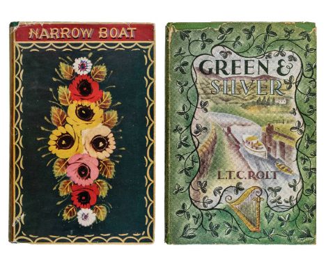
Rolt (Lionel Thomas Caswall). Narrow Boat, 1st edition, 1944, frontispiece and illustrations by D.J. Watkins-Pitchford, original cloth in dust jacket, torn with loss mostly at head and foot of spine, 8vo, with loosely inserted autograph letter signed from L.T.C. Rolt to Phillip Mawdsley-Sprot, dated December 29th 1944, on headed notepaper from 'M.B. Cressy', with original envelope, Rolt replies most emphatically in the negative to Mawdsley-Sprott's enquiry as to whether 'Cressy' was for sale, offers to consign him to the nether regions, apparently for speeding on the cut, and goes on to offer him advice on buying and refitting a boat, together with Green and Silver, 1st edition, 1949, black & white plates from photographs by Angela Rolt, front free endpaper inscribed by L.T.C. Rolt, dated September 10th 1950, and signed by Angela, original cloth in dust jacket, torn with some loss at head and foot, 8vo, with The Inland Waterways of England, 1st edition 1950, colour frontispiece and black & white plates, folding map at rear, front free endpaper signed by L.T.C. Rolt, and with loosely inserted manuscript leaf of notes in his hand, and related letter from Angela Rolt, original cloth, dust jacket torn with slight loss at head & foot of spine (repaired to verso), 8vo, plus other works by L.T.C. Rolt and related, including four signed and a copy of Narrow Boat from the collection of Denys Watkins-Pitchford (27)

Willans (Kyrle William, 1883-1973). Bradshaws's Canals and Navigable Rivers of England and Wales. A Handbook of Inland Navigation for Manufacturers, Merchants, Traders, and Others: Compiled, after a Personal Survey of the whole of the Waterways, by Henry Rodolph De Salis, 1928, without folding map at rear, signatures to front pastedown and title, extensive annotations in pencil to endpapers (mainly distance tables for journeys undertaken), some stains and marks, orginal cloth, worn with old adhesive tape repair to spine, 8vo, contained in purpose-made book box with dark green half morocco gilt binding, together with another copy of the same edition with folding map present The working copy of 'Bradshaw', purchased by Kyrle Willans sometime before he acquired the narrowboat 'Cressy' in 1929. With his name and address in ink to the front pastedown when the family lived at The Grange, Milton. The purchase of 'Cressy' would appear to have taken place, according to L.T.C. Rolt's recollections, after the family moved to Shropshire (Rolt was Willans' nephew). It is possible the volume was given to J.W. 'Bill' Willans as a present as it includes his signature 'J.W. Willans, Xmas 1929' to the front endpaper. Several journeys, generally out and back from Braunston, are recorded roughly in the pencilled notes to the endpaper. The trip, with Rolt as a crew member, where they travelled as far south as Cassio Bridge is listed. (2)
Sale Particulars. Norfolk - Particulars and Conditions of Sale of the Valuable Freehold Estates Late the Properties of Edward Press, Esq., deceased, consisting of the the North Walsham & Dilham Canal, Corn Mill, Granaries, Business Premises, Cottages, and Agricultural Land, also, by instructions of the Owner, a Freehold Dwelling House & Land known as "Croft House," Belaugh, Near Wroxham Station, Wednesday, 11th September, 1907, at the Mart, Tokenhouse Yard, London, EC, Auctioneer, Harry H. Arnold, folding and single page lithograph plans, black & white illustrations from photographs, with signed conditions of sale for lot 2 (dwelling house at Dilham), original cloth spine strip, slim folio, together with North Walsham, Edingthorpe & Smallburgh, Norfolk. Particulars and Conditions of Sale of the Valuable Freehold Estates Late the Properties of Edward Press, Esq., deceased, at the Royal Hotel, Norwich, on Saturday, 24th November, 1906, folding colour lithograph plans, original printed wrappers, slim folio, with North Walsham and Edingthorpe, Norfolk. Particulars and Conditions of Sale of the Valuable Freehold Properties comprising: Commodious Block of Buildings..., a Water & Steam Corn Mill..., to sell at Auction at the King's Arms Hotel, North Walsham, on Thursday, 25th August, 1910..., Messrs. Sadd & Bacon, folding colour lithograph plan, original printed wrappers, some toning, slim folio, plus a large collection of canal related guidebooks, booklets, pamphlets and some magazines, including British Waterways, The Waterways Series and the Inland Waterways Association publications, plus few other canal related items including first day covers and postcards, etc., plus Smiths New Map of the Inland Navigation of England and Wales, 1803, folding hand-coloured engraved map sectionalised on linen, contained in original slipcase (6 cartons)
De Salis (Henry Rodolph). Bradshaws Canals and Navigable Rivers of England and Wales. A Handbook of Inland Navigation for Manufacturers, Merchants, Traders, and Others..., 1928, folding colour lithograph map in rear pocket, original green cloth gilt, large 8vo, together with Priestley (Joseph), Historical Account of the Navigable Rivers, Canals and Railways throughout Great Britain, 2nd edition with an introductory note on the compiler by W.H. Cahaloner, Frank Cass & Co., 1967, facsimile of 1831 edition, black & white frontispiece and folding plate at rear, original cloth gilt in transparent plastic dust-jacket, 4to, with Dalton (R. & Hamer, S.H.), The Provincial Token-Coinage of the 18th Century, reprinted with introductory notes and additions, 1996, black & white illustrations, original cloth gilt, 4to, and Wilson (W. Eric), Inland Waterways of Great Britain, 1st edition, 1939, folding colour lithograph map loosely inserted at rear, original cloth in dust-jacket, 8vo, plus other British canal and inland waterways related, plus few aviation reference including RAF Airfields of World War 2, by Jonathan Falconer, 2012 (3 shelves)
Priestley (Joseph). Historical Account of the Navigable Rivers, Canals and Railways throughout Great Britain, 2nd edition with an introductory note on the compiler by W.H. Cahaloner, Frank Cass & Co., 1967, facsimile of 1831 edition, black & white frontispiece and folding plate at rear, original cloth gilt in transparent plastic dust-jacket, 4to, together with Wilson (W.Eric), Inland Waterways of Great Britain, A handbook giving the mjore important particulars of the Principal Canals and Rivers of England and Scotland, arranged in a concise form for Yachtsmen, 1st edition, 1939, folding colour lithograph map loosely contained at rear, original cloth, spotted, tall 8vo, with Edwards (Lewis A.), Inland Waterways of Great Britain and Ireland, 1962, black & white plates, occasional spotting, original cloth gilt in dust-jacket, large 8vo, plus other British canal and inland waterway history and reference etc. (3 shelves)
Baker (C. Alma). Deep Sea Big Game Fishing Bay of Islands, New Zealand. A Special Article being a rough guide for the uninitiated to these renowned fishing waters, suggested tackle, and fishing methods favoured..., 1st edition, Glasgow: Printed for Private Circulation by Robert Maclehose & Co., Ltd., 1937, black & white frontispiece and illustrations from photographs, bookplate of P & O liner Narkunda to upper pastedown, original blue cloth gilt with pictorial panel to upper board, spine and head of boards faded, slim 8vo, together with Rollett (F. Carr), Angling in New Zealand, 1st edition, Auckland, Melbourne & London: Whitcombe & Tombs, [1924], black & white plates and illustrations from photographs, advertisements, map endpapers, original green cloth, spine faded, slim 8vo The P & O liner SS Narkunda (Capt. L. Parfitt, D.S.C.), was serving as an auxiliary transport during the Allied landings in French North Africa in November, 1942. She disembarked her troops at Bougie (now called Beja‹a, a Mediterranean Sea port town in north eastern Algeria) and had turned about for home when, toward evening on the 14th, she was bombed and sunk some distance off Bougie. Thirty-one persons were killed. Capt. Parfitt was among the survivors. (2)


Adrichomius (Christianus). Theatrum Terrae Sanctae et Biblicarum Historiarum, Cologne, Officina Birckmannica, sumptibus Arnoldi Mylii, 1593, lacks title (*1), 10 unnumbered preliminary pages, 286 numbered pages of text, two pages Catalogus Auctorum, 26 pages of index, plus colophon leaf at end, large folding engraved map of the Holy Land entitled Citus Terrae Promissionis (heavily creased and some fraying to edges, with slight loss, and waterstained to upper and lower margins, and 9 (of 11) folding engraved maps, including large folding plan of Jerusalem (torn along centre fold and with some waterstains and minor losses, with old paper repair to verso), occasional marginal waterstaining and soiling elsewhere, preliminary leaves partially loose and a little frayed to edges, 19th century bookplate of William Anketell, Anketell Grove, to front pastedown, contemporary blind panelled full calf, gilt decorated spine with gilt coat of arms to central band bearing the motto Vade ad Formicam, some wear with a little loss to head and foot of spine, and the leather binding detached along upper joint, folio (38.5 x 25.5 cm, 15 x 10 ins) Ex libris William Anketell (1790-1851), of Anketell Grove, County Monaghan, Ireland. Nebenzahl, Maps of the Holy Land, 33. The second edition of Christian Adrichem's important biblical atlas with the large map of the Holy Land and the plan of Jerusalem present, and 8 of the 10 regional maps (lacking the two maps of Tribus Neptalim and Deserti Phalan). The plan of Jerusalem is 'the most dramatic and important of the 16th century, according to Nebenzahl, Maps of the Holy Land. Sold with all faults, not subject to return. (1)
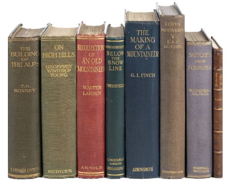
Campbell (William). Sketches from Formosa, 1st edition, Marshall Brothers, Limited, 1915, 15 plates, colour map, spotting to outer leaves and to leaves facing text, original blue cloth gilt, spine very slightly faded and rolled, but a bright copy, 8vo, together with: Dutton (Eric Aldhelm Torlough), Kenya Mountain, with an introduction by Hilaire Belloc, new edition, Jonathan Cape, 1930, 56 photographic plates, 3 sketch-maps (1 double-page), 1 folding colour map, free endpapers brown, front pastedown inscribed by the author 'To Captain Gilchrist, in return for many kindnesses from E. A. T. Dutton, Modasa, October, 1930', original blue cloth, spine and front board faded, large 8vo, Tyndall (John), Mountaineering in 1861. A Vacation Tour, Longman, Green, Longman, and Roberts, 1862, 2 wood-engraved plates including frontispiece, small tide-mark to upper inner corner of each, contemporary morocco, slightly rubbed, 8vo, Spender (Harold), Through the High Pyrenees, with Illlustrations and Supplementary Sections by H. Llewellyn Smith, 1st edition, A. D. Innes & Company Limited, 1898, photogravure frontispiece, 30 plates, 5 maps (1 folding), occasional spotting, original green cloth, spine sunned, small mark to front board, 8vo, Mummery (Albert Frederick), My Climbs in the Alps and Caucasus, 1st edition, T. Fisher Unwin, 1895, 11 plates including frontispiece (mainly photogravures), spotted, original cloth, rubbed, large 8vo, and approximately 20 others, all mountaineering, original cloth, 8vo Neate D61 (for Dutton, 'still the classic work on Mount Kenya'), T77 (Tyndall), S152 (Spender), M181 (Mummery). (29)
Cassell, Petter & Galpin. Cassell's British Atlas: Consisting of the Counties of England with large divisional maps of Scotland, Ireland and Wales..., circa 1870, printed title and index, numerous uncoloured regional and county maps by Edward Weller, town plans of the principal cities, map of the 'Landmarks of London' railway maps, two sheet plan of London after Ralph Agas, bound with Cassell's General Atlas..., circa 1870, sixty-two (as per list) uncoloured maps of foreign countries with a further sixty-three multiple sheet maps of countries, occasional spotting and staining, contemporary half morocco gilt, worn and stained, folio (1)
Bagnall (James E.). The Flora of Warwickshire, London & Birmingham, 1891, folding map contained in rear pocket, original cloth, a few light dampstains to lowetr cover, 8vo, together with The Flora of Berkshire, by George Claridge Druce, Oxford, 1897, folding map contained in rear pocket, previous owner signature, original blue cloth, spine a little faded and rubbed at foot, 8vo, plus The Flora of Dorsetshire, by John Clavell Mansel-Pleydell, 2nd edition, Dorchester, 1895, two folding maps, one or two light spots, original cloth gilt, a couple of light stains, 8vo, with other floras including George Druce's The Flora of Buckinghamshire, 1926 (with a letter from the author; Wilfred Blunt's copy), John Amphlett & Carleton Rea's The Botany of Worcestershire, 1909, W. Keble Martin & Gordon Fraser's Flora of Devon, 1939 and Donald Grose's The Flora of Wiltshire, 1957 (13)
Cellarius (Christopher). Geographia Antiqua: Being a Complete Set of Maps of Antient Geography, 1793, 33 double-page engraved maps, each with manuscript number to verso, some light spotting and soiling, previous owner stamp to front endpaper (detaching), bookplate partly removed from front pastedown, contemporary calf-backed boards, some wear to spine and edges, 4to, together with An Atlas of Ancient Geography, by Samuel Butler, 1822, engraved outline map, engraved title and 20 double-page maps, most with outline colour, some light offsetting and spotting, front hinge broken, contemporary half calf, rebacked, lower joint splitting, edges rubbed, 8vo, plus Theodor Menke's Orbis Antiqui Descriptio, 2nd edition, 1855 (3)
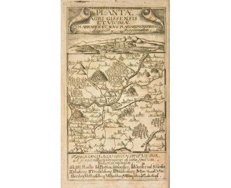
Dillenius (Johann Jakob). Catalogus Plantarum sponte circa Gissam Nascentium. Cum Appendice, qua Plantae post editum Catalogum, circa & extra Gissam observatae recensentur, Johann Maximilian von Sande, Frankfurt, 1719, engraved map frontispiece, 16 engraved plates, a little light toning, contemporary annotations at front, previous owner inscription of John Innys, 1769, Redland Court, Gloucestershire, armorial bookplate of George Weare Braikenridge, Gloucestershire County Library ink stamp to front pastedown, contemporary calf gilt, manuscript author name to spine label, joints and edges rubbed, 8vo Nissen BBI 490; Stafleu & Cowan TL2 1470. Second edition (first published in Frankfurt in 1718) and the first with the appendix, of Dillenius's flora on the area around Giessen in Germany. Bibliographically confusing with Nissen calling for 18 plates, Stafleu & Cowan calling for 16. Presentation copy, inscribed at foot of title: "Gift of the author to Littleton Brown, M.A., F.R.S.". Brown is mentioned by Dillenius in his Historia Muscorum, and assisted him by gathering specimens in Wales, Herefordshire and Shropshire. Interesting provenance with John Innys (died 1778), a London bookseller, who formed a publishing partnership with his brother William before later moving to Redland Court in Bristol. George Weare Braikenridge (1775-1856) was an English antiquarian, who purchased Broomwell House in Brislington, Bristol in 1823 where he amassed the important Braikenridge Collection of Bristol related history and topography. The collection is mostly now held at the Bristol City Museum and Art Gallery, Bristol Central Library and Bristol Archives. (1)
[Hayes, Samuel]. A Practical Treatise on Planting; and Management of Woods and Coppices, 3rd edition, 1822, engraved title, five engraved plates, engraved vignettes, occasional minor spotting, modern half calf, spine a little faded, 8vo, together with Remarks on Forest Scenery, and other Woodland Views, (relative chiefly to Picturesque Beauty) Illustrated by the scenes of New-Forest in Hampshire, by William Gilpin, 2 volumes, 1st edition, 1791, half titles, folding map, 31 plates, some offsetting and marginal damp stains, contemporary sprinkled calf gilt, spine darkened with chips to labels, 8vo, plus The Woodlands: Or, a Treatise on the preparing of ground for planting; on the planting; on the cultivating; on the pruning; and on the cutting down of Forest Trees and Underwoods..., by William Cobbett, 1st edition, 1825, illustration, advertisement leaf at end, a little light spotting, front hinge broken, previous owner signature, original cloth-backed boards, spine faded with small tears and chips, 8vo (4)
Scully (Reginald W.). Flora of County Kerry including the Flowering Plants, Ferns, Characeae, &c., 1st edition, Dublin, 1916, black & white plates and folding colour map, top edge gilt, remainder untrimmed, original cloth gilt, 8vo, together with More (Alexander Goodman), Contributions towards a Cybele Hibernica, being outlines of the geographical distribution of plants in Ireland, 2nd edition, Dublin, 1898, folding colour map frontispiece, top edge gilt, remainder untrimmed, original cloth gilt, 8vo, with Stewart (Samuel Alexander), A Flora of the North-East of Ireland..., 1888, top edge gilt, original cloth gilt, 8vo, plus other related flora and related, including British Mosses by F.E. Tripp, 2 volumes, 1874, The Royal Natural History by Richard Lydekker, 6 volumes, 1894 and The Cambridge British Flora by C.E. Moss, volumes 2 & 3 only, 1914-1920 (75)
Marshall (William). The Rural Economy of Gloucestershire; Including its Dairy: Together with the Dairy Management of North Wiltshire: and the Management of Orchards and Liquor in Herefordshire, 2 volumes, 1st edition, Gloucester, 1789, half title to volume I, folding engraved map, a few light spots, contemporary calf, spines and edges a little rubbed, 8vo, together with The Rural Economy of Yorkshire, 2 volumes, 1st edition, 1788, half title to volume I, two folding engraved maps, some light spotting, library stamps at head of titles, modern library cloth, 8vo, plus The Rural Economy of the Midland Counties, 2 volumes, 1st edition, 1790, half title to volume I, folding engraved map, some offsetting and spotting, contemporary calf, spine and edges rubbed, 8vo (6)
Relhan (Richard). Flora Cantabrigiensis, 1st edition, Cambridge, 1785, seven engraved plates (one folding and one partly hand-coloured), bound with two supplements at end 1786 & 1788, some light spotting, endpapers renewed, contemporary tree calf, rebacked, a little rubbed and stained, 8vo, together with Warner (Richard), Plantae Woodfordienses. A catalogue of the more perfect plants growing spontaneously about Woodford in the County of Essex, printed for the author, 1st edition, 1771, title with engraved circular monogram, bound with the supplement 'Additions to Warner's Plantae Woodfordienses 1784' at end, some light soiling and toning, small book label, near contemporary calf-backed boards, spine faded, 8vo (Henrey 1477 & 1478), plus Pitt (William), General View of the Agriculture of the County of Stafford: With observations on the means of its improvement, 1796, folding hand-coloured engraved map, 14 engraved plans and plates, several folding, light offsetting, bookplate, contemporary half calf, joints splitting, spine rubbed, 8vo, with three others including W.J. Hooker's Flora Scotica, 1821 and W.A. Leighton's A Flora of Shropshire, 1841 (6)
Jessen (B.H.). W.N. McMillan's Expeditions and Big Game Hunting in Sudan, Abyssinia & British East Africa, 1st edition, 1906, portrait frontispiece, large folding map contained in rear pocket, front endpaper a little toned, ex-libris Bournemouth Natural Science Society bookplate and marks to front pastedown, original red cloth, spine and extremities faded, shelf number sticker at fot of spine, small 4to (1)

Kluger (Zoltan, photographer, & others). Aspects of Jewish Development in Palestine. A Photographic Record, submitted to the Anglo-American Committee of Inquiry by the Jewish Agency of Palestine. Jerusalem: March, 1946, 21 leaves with mounted letterpress title and 63 corner-mounted black and white photographs with printed caption slips in English, photograph sizes ranging mostly from 11.5 x 17.5cm to 23.5 x 17cm, some with wetstamp credit to versos of Z. Kluger of the Orient Press Photo Co., Tel Aviv, folding colour map in pocket to rear pastedown (Palestine To-Day. An up-to-date map of the Holy Land, Prepared by D. Benvenisti & B. Lurye, Special Reprint for the Youth Department of the Zionist Organisation and the Immigration Department of the Jewish Agency, Published by Kiryat Sepher Ltd, Jerusalem, 1946), signed presentation inscription in Hebrew in black ink to front free endpaper verso, translating as 'To Sir Simon Marks, in memory of his visit to the land [i.e. Israel]. With love and appreciation, [signed] Ritzka lo Peh. Nisan 4 [i.e. 4th May] 1946', original vellum boards with leather spine and leather spine ties, split along joints at foot of spine, oblong folio (34 x 37cm) An extremely rare photographic record of Jewish development projects in Palestine. This album was produced as a piece of Zionist propaganda for the Anglo-American Committee of Inquiry. This was a committee of six British and six American representatives appointed in 1945 'to examine political, economic, and social conditions in Palestine as they bear upon the problem of Jewish immigration and settlement therein and the well-being of the peoples now living therein'. The committee travelled to, and heard testimony in, Poland, the Warsaw Ghetto, Cairo, Damascus, Beirut, Baghdad, Riyadh and Amman. This album was presented to members of the committee by the Jewish Agency for Palestine, and includes images of clearing of swamps, building of new villages and towns such as Tel Aviv and progress in settling the Negev desert. There are some 28 aerial photographs, including shots of Tel-Aviv and Jerusalem, which are probably the work of Zoltan Kluger (1896-1977). Born in Hungary, Kluger spent 1933-1958 as chief photographer at the Orient Press Photo Co agency in Tel Aviv, and was a pioneer of non-military aerial photography in Palestine. Believed to be one of only of about 12 copies, this is an exceptional association copy. The London office for the Jewish Agency for Palestine was set up by Dr Chaim Weizmann, with the help of the Marks & Spencer partners, Sir Simon Marks and Israel Sieff. Sir Simon Marks (1888-1964) was president of the Joint Palestine Appeal and honorary vice-president of the Zionist Federation, and following the establishment of Israel in 1948 he worked tirelessly to help the fledgling state overcome its many problems. (1)
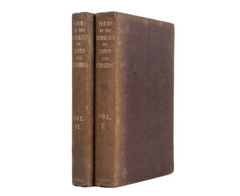
Lloyd (Sir William). Narrative of a Journey from Caunpoor to the Boorendo Pass in the Himalaya Mountains, via Gwalior, Agra, Delhi, and Sirhind. And Captain Alexander Gerard's Account of an Attempt to Penetrate by Bekhur to Garoo and the Lake Manasarowara... edited by George Lloyd, 2 volumes, 1st edition, J. Madden & Co., 1840, 3 engraved maps (2 folding), short splits to 1 fold of each folding map, volume 2 folding map with clean tear along part of stub, yellow surface-paper endpapers with contemporary ownership inscriptions 'Louisa Durnford, 1840', volume 1 front inner hinge superficially cracked but firm, original maroon cloth, spines sunned, pale mottling and a few marks to covers, tips bumped, 8vo Yakushi L238. Lloyd (1782-1857) was 'one of the first Europeans to reach the peak of any Himalayan snow-capped mountain' (Dictionary of Welsh Biography). (2)
Malte-Brun (Conrad). Atlas Complet du Precis de la Geographie Universelle, Paris, 1837, title page and seventy-two (complete) engraved maps and charts, including a reduced Peutinger table, geological maps and diagrams, all (with the exception of the Peutinger table) with contemporary outline colouring, index at rear, marbled endpapers, contemporary half morocco gilt, folio, together with Desnos (Louis Conrad), Atlas de France. divis‚e en ses gouvernemens militaires et en ses g‚n‚ralit‚s, subdivis‚e en toutes ses provinces et petits pays &c. Assujetti aux Nouvelles Observations de M.M. de l'Acad‚mie Royale des Sciences..., Paris, 1769, double page decorative title, general folding map of France, two uncoloured plans of Paris and fifteen double page engraved maps with contemporary outline colouring (complete), some dust soiling and slight staining largely confined to margins, near contemporary manuscript numbers to verso and recto of each map, near contemporary manuscript ownership signature to verso of title, contemporary half morocco gilt, worn and frayed with spine partially lacking, folio The first volume described is from the library of Marie Caroline, Duchess de Berry (1798 - 1870). (2)
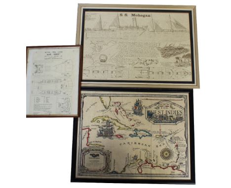
A 1930s 17th century style NCL map of the West Indies, marked 'MS Starward', a Royal Mail Lines deck plan from RMS Ebro, and plan and elevation of SS Mohegan, 38 x 56cm and Three mid-to-late 20th century photographic ocean liner prints to include a landscape picture of five steam ships heading into harbour, including the SA Vaal, 88 x 41.5cm, a Union Castle Saf Marine photographic print of the SA Vaal and a Cunard print of the Queen Elizabeth II, all framed and glazed (6).


GERMAN PLANS FOR THE INVASION OF ENGLAND IN 1940, OPERATION 'SEALION' edited by W.E. Parry, Director of Naval Intelligence, 48 leaves and one map, typescript, original cloth-backed printed boards, February 1947, one of 80 copies A fascinating account compiled by Vice Admiral Kurt Assman taken from German naval archives of the events that ultimately proved to be the cancellation of the invasion of England, code named Sealion . The account varies from exaggerated hopes to pessimistic forecasts and the operation probably failed owing to Goering's lukewarm support and doubt that an invasion would take place or succeed. A summary of the Naval Staff's appreciation, dated 10th September, noted There is no sign of the defeat of the enemy's airforce over Southern England. Sealion was postponed until January 1941, again in May 1941 and then shelved indefinately. Kurt Assman (1883-1962) in WWI commanded the 'Torpedoboat Flotilla Flanders'. In WWII he was head of naval archives until his retirement in June 1943.

A hand tinted map of Westmorland, Lancashire, Cheshire, North Wales and the Isle of Man by Gerardum Mercatorem circa 160036x41cm, verso printed description, framed and glazed, loose black and white map of De La Pologne by Mr Philippe circa 1787, 27x37cm and a coloured plate of Polish costume A hand tinted map of Westmorland, Lancashire, Cheshire, North Wales and the Isle of Man by Gerardum Mercatorem circa 160036x41cm, verso printed description, framed and glazed, loose black and white map of De La Pologne by Mr Philippe circa 1787, 27x37cm and a coloured plate of Polish costume

A hand tinted map of the County Palatine of Lancaster by Robert Morden, mid 18th CenturyThe hand tinted map showing the various hundreds of Lancashire, 41x35cm, further coloured map of Lancashire 19th Century, 39x33cm, both framed and glazed (2) A hand tinted map of the County Palatine of Lancaster by Robert Morden, mid 18th CenturyThe hand tinted map showing the various hundreds of Lancashire, 41x35cm, further coloured map of Lancashire 19th Century, 39x33cm, both framed and glazed (2)


A hand tinted map of the County Palatine of Chester by John Speede, late 17th CenturyHand tinted map showing the City of Chester and various Earls of Chester's coats of arms, 43x52cm, verso with printed description, framed and glazed A hand tinted map of the County Palatine of Chester by John Speede, late 17th CenturyHand tinted map showing the City of Chester and various Earls of Chester's coats of arms, 43x52cm, verso with printed description, framed and glazed Looks old


A group of handwritten records for Air Raid Damage and Bombing of Bournemouth and surrounding areas, including a 1940 book with recorded where bombs where dropped and British and German planes had crashed along with a map, another two noting Air Raid alerts from June 20th 1940 - July 14th 1944, and other items (parcel)please see a few images of the lot, there are many more pages, would suggest viewing if possible

A large collection of books and newspapers, including A Short History 7th Armoured Division, WWII period newspapers, a man's Handwritten 'CV', 19th Century documents, the 8th Army, a framed and glazed map of Somerset, having various Fire Service, Civil Defence and Military emblems around the edge and more (parcel)

WW1 British Regimentally Marked Cuff Rank Uniform Grouping Attributed to Lieutenant Archibald Baxter Sharp Royal Warwickshire Regiment, good untouched example of the four pocket officers service dress tunic with cuff rank. Complete with bronze officers regimental collar badges with territorial “T’s” underneath. To each arm is felt formation insignia of the 53rd (Young Soldier) Battalion of the Royal Warwickshire regiment. Above the breast pocket is medal ribbon bar for WW1 service. Leather edging trim to the tunic cuffs. Accompanied by a pair of officers khaki breeches, 1916 dated officers Sam Browne leather belt fitted with cross strap and ammunition pouch, 1917 dated leather case (only) for an officers compass, officers canvas wash role, various riding spurs, Musketry Regulations book 1909 with his name inked inside, officers field message book, map of the Italian front and 2x re-print photographs showing Sharp wearing this uniform when rank of 2nd Lieutenant. The tunic shows honest service wear and does have some light moth holes and areas of stitching faults. Lieutenant Archibald Baxter Sharp enlisted into the ranks with the Bedfordshire Yeomanry Reserves and was commissioned into the 1/8th Battalion Royal Warwickshire Regiment in Nov 1917. He was attached to the 1/7th Battalion and served with them in Italy, where he would have participated in the fighting on the Asiago Plateau as well as the Battle of the Vittoria Veneto. He was invalided home with Rheumatism in December 1918. He later served with the 53rd (Young Soldier) Battalion, Royal Warwickshire Regiment and spent some time in Cologne, Germany with The Army of Occupation. He was demobbed in 1920.

WW1 Period Cavalry Officers & Royal Flying Corps Observers Map Board, fine example of the wooden map board with compass set into the top section, brown leather strap to the reverse. Retailer marked “Hugh Rees Ltd London & Camberley” and maker marked “Aston & Mander Ltd London”. Housed in its original canvas carry case with long brown leather shoulder strap. Un-dated but remaining in very good condition.
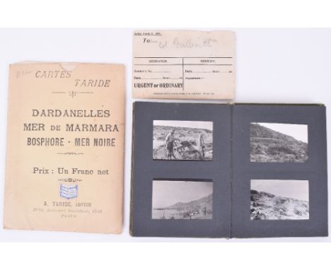
WW1 British Photograph Album of Gallipoli Interest and Battlefield Message Sent to the Commanding Officer of the 7th Highland Light Infantry, Telling Him “You Are Firing Into Us Please Stop As We Are In A Bad Enough Trench”, the note is written in pencil and housed in an original despatch envelop addressed to Col Galbraith, the note is written by a Major but his name is not clear, the note states in full, “you are firing into us please stop – as we are in a bad enough trench + need WATER – TOOLS – ammunition- we are in the 2 Turkish trench TO OC 7th HLI” he has crossed out 157th Bde. The photograph album in the lot consists of snapshot photographs taken on the Gallipoli Peninsular, good images of Trenches, Turkish Prisoners, captured weapons, Indian soldiers, ANZAC cove, etc. Some later images appear to be taken on the Western Front and then some back in the UK after the war. Also accompanied by a French coloured map of the Dardanelles in card folder. An interesting grouping relating to one of the most famous actions of WW1.
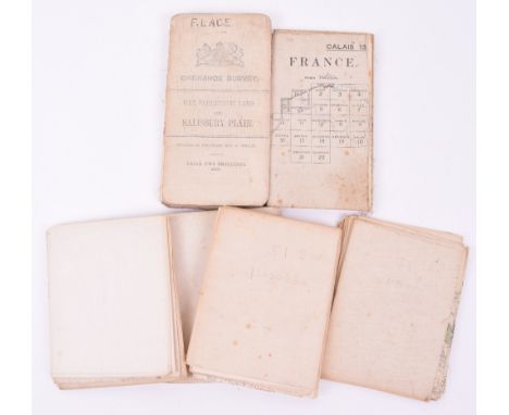
6x WW1 Period Trench Maps and Other Maps, all being linen backed examples, including 1915 War Office example of Calais France, 14th October 1918 Trench Map France 1:20,000 scale Edition 3a, 1918 Ordnance Survey of Belgium and Part of France 1:40,000 scale Edition 2, Trench Map 1918 France (Foret de Mormal) 1/20,000 scale, plus others. Various conditions. (6 items)


-
109198 item(s)/page