We found 109198 price guide item(s) matching your search
There are 109198 lots that match your search criteria. Subscribe now to get instant access to the full price guide service.
Click here to subscribe- List
- Grid
-
109198 item(s)/page


Lot 233
TWO ANTI-SLAVE TRADE PATROL LOGBOOKS FROM H.M.S. NORTH STAR 1834-6 Kept by John Towsend (midshipman), the first 16 July 1834-27 October 1836; the second 8 December 1835-27 October 1836, the first log discusses the voyage round Cape Horn and back again and in particular, mentions stays at Rio, Montevideo and Buenos Aires, 25th 1834; James Scott died from excessive drinking and was buried at sea; May 28th the ship anchored off Pernambuco; on 3 July received stores for the Falkland Islands where they docked on 24 July receiving fresh beef, lots of geese, rabbits and members of the crew, the only inhabitants of the islands; 4 August 1835 the ship again rounded Cape Horn in appalling weather causing the death of the ship's watchman from hypothermia; 16 March 1836 was given a cask of whiskey by an American brig; the North Star arrived back in England on 27 October 1836, this and the following were written by John Francis Townsend, midshipman, the captain being Octavius Venables Cyril Harcourt, modern wrappers, folio -- 12¾ x 8in. (32.5 x 20.5cm.); together with another logbook mostly concerned with ordinary tasks, carpenters (numerous repairs including sails), washing clothes and the ship, exercising marines, espying Australian and French ships, reading articles of war, catching turtles, etc., 61ff. (including one blank), contemporary half roan, red morocco label on front cover, folio -- 12 x 7½in. (30.5 x 18.5cm.), 8 December 1835-27 October 1836; and a transcript of the log; together with a large folder additional support material pertaining to Townsend between 1834-59 and including material when serving as First Lieut. of H.M.S. Pantaloon, an 8-gun brig capturing slavers on the African coast, including letters, manuscripts and an early (17th Century?) map of Ireland.(3, a lot)The North Star commissioned 1825 was stationed in the West Africa Squadron suppressing the slave trade - taking several Spanish and Brazillian slavers and after serving in the first Anglo-Chinese War (1841-42) was fitted for Arctic service between 1852-1854 searching for Sir John Franklin’s ill-fated North-West passage expedition. She was scrapped at Chatham Dockyard in 1860.

Lot 463
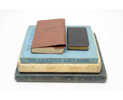
His Majesty's Stationery Office, Army Field Service Pocket Book 1914, with 1916 amendments, 8vo, soft cloth covs. with map pocket, illus. with diagrams, plates, tables and maps, Harrison & Sons, London; Cattaneo (Raffaele) Architecture In Italy, 4to, buckram, illus., 1896; Winner's Gems of Music, lge. 4to, printed cloth, illus. with sheet music and plates; The Queen's Gift Book, 4to, cloth, illus., c.1918; and The New Testament, 48mo, soft covs., published by Collins' Press, n.d. (5)


Lot 654
WILLIAM HENRY STOCKMAN (BRITISH 1935-2021) 'EDWARD BRIDGES TORBAY LIFEBOAT', the Arun class lifeboat clearing Torbay breakwater, signed lower left, oil on canvas, approximate size 49cm x 79cm (dirty marks to the canvas), Anthony Barratt pastel drawing of an Alsatian dog, Theodore Xaras locomotive print, two David Shepherd locomotive prints, four Joanna Lowe rose prints produced for the National Rose Society, Royal Geographical Society map of Sir Francis Drake's voyage, etched in silver over copper and inlaid with 24k gold together with other prints etc

Lot 379
° ° (England) An Impartial History of England ... to the Middle of the Year 1799 ... including, An History of the American War and Revolution... num. engraved plates and folded map; newly rebound blind-decorated calf, panelled spine with red labels, folio. Blackburn: printed by Hemingway and Nuttall, 1799


Lot 235
Collection of watercolour paintings by Audrey Langford, Sussex artist, including Bosham, several of Arundel, The Pier at Bognor, Boxgrove Priory, map of Chichester and The Harbour, West Wittering, Medmerry Milly, Selsey, and one other of Porlock Wier by Mike Tarr. *Donated in aid of the Winchcombe Museum Charity 'Raise The Roof' Appeal


Lot 96
Robert Morden, early maps of Lincolnshire engraved county map, hand-coloured in outline, approx 42 x 37 cms; Oxfordshire county map, hand-coloured in outline, sold by Abel Swale Aunsham & John Churchil, approx 36.5 x 42.5 cms and an engraved county map of Gloucestershire approx 43 x 37 cms (some loss and staining to lower right margin of the last map), all three framed and glazed.


Lot 112
Original vintage advertising poster published by the Kenwood Coproration for radio enthusiasts displaying world map with time zones, political boundaries, different radio frequencies and codes. Kenwood Corporation (originally known as Kasuga Radio Co. Ltd. and later Trio Corporation) was a Japanese company that designed, developed and marketed a range of car audio, hi-fi home and personal audio, professional two-way radio communications equipment, and amateur radio ("ham") equipment. Since October 2011, Kenwood survives as the brand of JVCKenwood Corporation. Amateur radio, also known as ham radio, is the use of radio frequency spectrum for purposes of non-commercial exchange of messages, wireless experimentation, self-training, private recreation, radiosport, contesting, and emergency communication. Horizontal. Very good condition, minor creasing on edges, minor staining. Country of issue: Unknown, designer: Unknown, size (cm): 63x87, year of printing: 1970s.

Lot 219
Original vintage travel poster - The Gleneagles Map of The Heart of Scotland showing 5000 Square Miles of the Highlands & Lowlands around Gleneagles Hotel. This fold out illustrated map of Scotland and London Midland & Scottish Railway route marked on the map in red. The cover features a great design of thistle heart framing the title, Gleneagles logo with an eagle and tartan, caption reads - Gleneagles Hotel and Gleneagles Golf Courses are unsurpassed, - set over blue background. Constructed and printed by W. & A. K. Johnson Ltd, Edinburgh. McCorquodale & Co., Ltd., Glasgow. Good condition, folds, creasing, browning, minor staining, hardback cover, small paper loss on cover image, paper skimming on cover image. Country of issue: UK, designer: Unknown, size (cm): 83x113, year of printing: 1930.
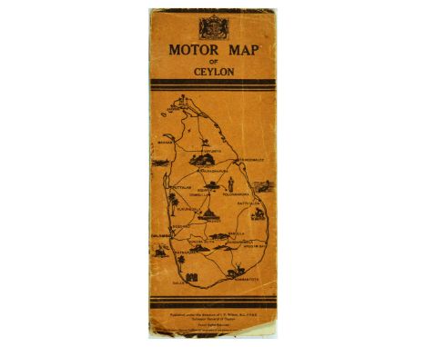
Lot 224
Original vintage double-sided travel map poster Motor Map of Ceylon, Published under the direction of I.F. Wilson, M.C., F.R.G.S. Surveyor General of Ceylon, the map presents main trunk roads, motorable roads, motor ferries, cart tracks, railways, petrol depots, rest houses, hotels, police stations, hospitals, resident dispensaries, telegraph and/or telephone offices, telephone boxes, province boundaries, light houses, and aerodromes. Horizontal. 31x12cm when folded. Fair condition, folds, tears, creasing, staining, paper losses on cover, double sided. Country of issue: UK, designer: Unknown, size (cm): 61x80, year of printing: 1940s.

Lot 252
Original vintage travel poster Britain, featuring a pictorial map with fun colourful numbered illustrations and a list marking places of interest like castles, zoos, museums. forests, wildlife, portraying national costumes and traditional buildings. Published by James Galt and Company Limited. Good condition, creasing, pinholes, paper losses, tears, staining. Country of issue: UK, designer: Stephenson / Smith, size (cm): 101x74, year of printing: 1960s.
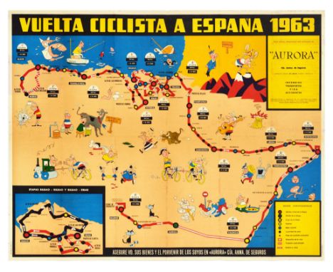
Lot 278
Original vintage illustrated map poster for the Vuelta Ciclista A Espana 1963 showing the cycling route of the 1963 Tour of Spain marked as a red line with information on the distances and colourful cartoon style images along each stage of the race including a man stranded at sea, a fisherman with a shark, a man playing music on a guitar and singing, cyclists climbing the mountains, being pulled by concrete roller, bull chasing a man, front and back covers in purple on the reverse. Good condition, folds as issued, small tears, foxing, staining, folds down to leaflet size. Country of issue: Spain, designer: Unknown, size (cm): 57x70, year of printing: 1963.
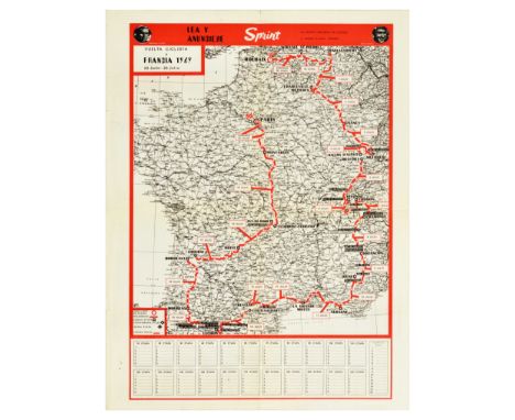
Lot 280
Original vintage sport poster from Sprint - a Spanish cycling magazine for Tour de France 1969 29 June - 20 July, featuring a map of France with the route marked in red with the start in Roubaix and finish in Paris, marking 22 stages covering a distance of 4117km, the reverse of the poster features ?Quien es Quien? - Who is Who in the Spanish Cycling Federation with photographs, and short descriptions of the federation members. The 1969 Tour de France bicycle race was won by a Belgian cyclist Eddy Merckx, followed by Roger Pingeon and Raymond Poulidor from France. Good condition, folds, tears, creasing, staining, double sided. Country of issue: Spain, designer: Unknown, size (cm): 63x48, year of printing: 1969.

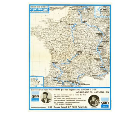
Lot 281
Original vintage sport poster from Cyclisme - a Spanish cycling magazine for Tour de France 1969 29 June - 20 July, featuring a map of France with the route marked in red with the start in Roubaix and finish in Paris, marking 22 stages covering a distance of 4117km. The 1969 Tour de France bicycle race was won by a Belgian cyclist Eddy Merckx, followed by Roger Pingeon and Raymond Poulidor from France. Good condition, folds as issued, staining, foxing. Country of issue: Spain, designer: Unknown, size (cm): 61x46, year of printing: 1969.

Lot 288
Original vintage sport poster from Cyclisme - a Spanish cycling magazine for Tour de France 1970, 27 June - 19 July, featuring a map of France with the route marked in red with the start in Limoges and finish in Paris, marking 23 stages covering a distance of 4254km. The 1970 Tour de France bicycle race was won by a Belgian cyclist Eddy Merckx, followed by Joop Zoetemelk from Netherlands, and Gosta Pettersson from Sweden in third. Very good condition, folds as issued, minor staining, tears. Country of issue: Spain, designer: Unknown, size (cm): 55x33, year of printing: 1970.

Lot 289
Original vintage sport poster from Cyclisme - a Spanish cycling magazine for Tour de France 1971, held from 26 June - 18 July, featuring a map of France with the route marked in red with the start in Mulhouse and finishing in Paris, marking 22 stages covering a distance of 3608km. The 1971 Tour de France bicycle race was won by a Belgian cyclist Eddy Merckx, followed by Joop Zoetemelk - cyclist from Netherlands, and Belgian Lucien Van Impe in third. Very good condition, folded as issued, trimmed bottom edge. Country of issue: Spain, designer: Unknown, size (cm): 54x43, year of printing: 1971.
Lot 299
Original vintage sport poster from Cyclisme - a Spanish cycling magazine for Tour de France 1973, 30 June - 22 July, featuring a map of France with the route marked in blue with the start in Schveningen Netherlands, going through Belgium, and finishing in Paris, marking 20 stages covering a distance of 4090km, photographs of Raymond Pulidor and Cyrille Guimard below the map. The 1973 Tour de France bicycle race was won by a Spanish cyclist Luis Ocana, Bernard Thevenet from France took second place, and Spanish cyclist Jose Manuel Fuente ranked in third. Excellent condition, folds as issued. Country of issue: Spain, designer: Unknown, size (cm): 54x43, year of printing: 1973.
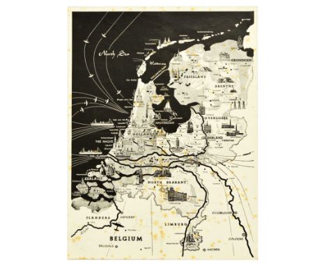
Lot 32
Original vintage advertising poster for Radio Nederland featuring a map of the Netherlands marking Rotterdam, The Hague, Amsterdam, with smaller illustrations of buildings, cattle, and boats, the reverse of the poster provides more information - Radio Nederland P.O. Box 137 Hilversum, with transmission times for Spain, South America, Argentina, Uruguay, Brazil, Bolivia, Chile, Paraguay, Antilles, Colombia, Ecuador, Peru, Venezuela, with other broadcasts in Arabic for Near East and Egypt, South Africa, Hindustan in English for South East Asia, Dutch for Indonesia and the Far East, Europe and Africa, Suriname and the Netherlands Antilles, and for Indonesia, Australia, New Zealand, the Pacific Area, Great Britain, Europe, United States, and Canada. Radio Nederland was a public radio and television network and an international public broadcaster, producing and transmitting programmes from 1947 to 2012. Fair condition, foxing, staining, folds, double sided. Country of issue: Netherlands, designer: Unknown, size (cm): 36x27, year of printing: 1950s.
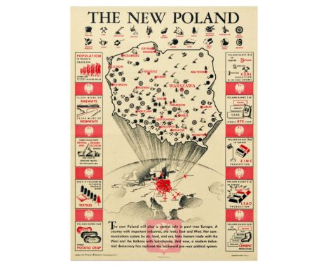
Lot 331
Original vintage propaganda poster prited in the USA: The New Poland. Design featuring a map of Poland indicating various industry locations throughout the country, with data on population, railway and highway length, Gdynia, Gdansk and Szczecin port traffic, textile, potato crop, coal production, rye crop, zinc, lead, and cement production; the caption below reads - The new Poland will play a central role in post-war Europe. A country with important industries, she looks East and West. Her communications system by air, land, and sea, links Eastern trade with the West and the Balkans with Scandinavia. And now, a modern industrial democracy has replaced he backwards pre-war political system. Source: The Polish Embassy in Washington D.C. Designed by Pick-S, New York. Very good condition, folds, creasing. Country of issue: USA, designer: Pick-S, size (cm): 76x56, year of printing: 1940s.
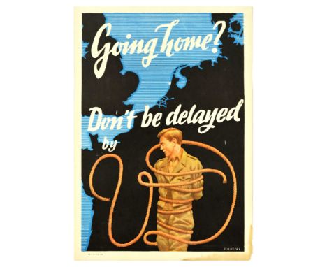
Lot 337
Original vintage propaganda poster aimed at allied soldiers stationed in Europe after the World War Two - Going home? Don't be delayed by V.D. - a military poster from World War II raising awareness about the venereal disease and reproductive health. Design featuring an illustration by a German artist Franz Oswald Schiffers (1902-1976) who worked previously for the Nazi Propaganda Ministry, depicting a soldier in uniform tied up with a rope that forms letters 'VD' with a black and blue map of Europe in the background. Fair condition, tears, drawing, staining, paper losses in margins. Country of issue: Australia, designer: Franz Oswald Schiffers (1902-1976), size (cm): 58x41, year of printing: 1946.
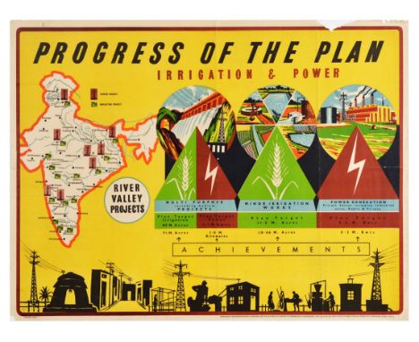
Lot 344
Original vintage propaganda poster Progress of the Plan Irrigation & Power featuring a map of India marking power projects and irrigation projects, with illustration insets on river valley projects depicting dam, field, factory, power lines all set over yellow background. Produced by the Directorate of Advertising and Visual Publicity, Ministry of Information & Broadcasting, Govt. of India and printed by M/S Bombay Fine Art Offset and Lithoworks, Bombay 1955-1956. Horizontal. Fair condition, folds, creasing, foxing, staining, large tears on edges, paper losses on top edge. Country of issue: India, designer: Unknown, size (cm): 74x98, year of printing: 1956.
Lot 368
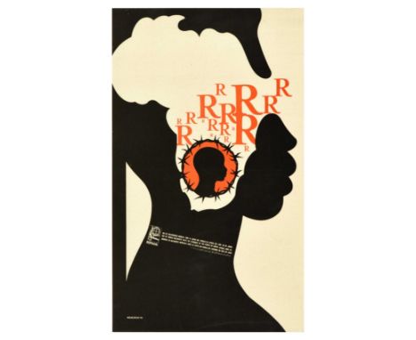
Original vintage propaganda poster Day of World Solidarity with the struggle of the people of South Africa June 26, featuring a silhouette of a person in black with a white map set over the face, orange letters 'R' and a smaller silhouette of a person on orange background with a barbed wire ring around it. OSPAAAL - Organization of Solidarity of the People of Asia, Africa & Latin America is a Cuban political movement that was founded in Havana in 1966. Very good condition, fold, creasing. Country of issue: Cuba, designer: Rene Felix Mederos Pazos, size (cm): 53x31.5, year of printing: 1970.
Lot 373
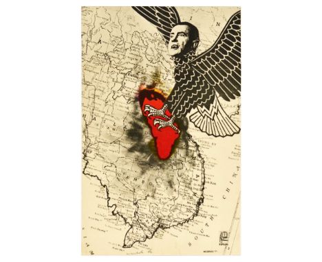
Original vintage anti Vietnam War propaganda poster issued by OSPAAAL, featuring an illustration of the president of the United States Richard Nixon with vampire or beast fangs portrayed as a bird of prey ripping red burning Indochina out of the map with it's talons, with a map of South East Asia as background. OSPAAAL - Organization of Solidarity of the People of Asia, Africa & Latin America is a Cuban political movement that was founded in Havana in 1966. Good condition, folds, creasing, small tears. Country of issue: Cuba, designer: Rene Felix Mederos Pazos, size (cm): 53x33, year of printing: 1971.

Lot 55
Original vintage advertising poster for Free World Peace and Brotherhood Fair 1955-1956 that took place in Cuidad Trujillo (Santo Domingo) - Dominican Republic, featuring an illustration of a man holding a white flag with a slogan - United for Peace and Progress, and other country flags in the other hand, with blue water surrounding the shape of the map of Dominican Republic. Printed by Ortega, Valencia. Good condition, folds, tears, small paper losses, creasing. Country of issue: Spain, designer: Unknown, size (cm): 100x62, year of printing: 1956.


Lot 1114
John Owen & Emmanual Bowen - a map of Cambridgeshire showing the road from London to Kings Lynn in Norfolk, later hand-coloured engraving, 20 x 12cm (unframed but mounted); Abel, Swan & Churchill - engraved map of Cambridgeshire (unframed); an 18th century engraved strip map showing the road from Huntingdon to Ipswich, unframed and uncoloured; and a single volume Handbook fo Stations, published by the British Transport Commission 1956 (4)

Lot 154
Mixed Lot including Four Boxes Files with spines in the form of Leather Bound ' Garden Notes ' Books, Lacquered Effect Paper Tray, Metal Stag Coat Hooks, Horn Handled Magnifying Glass, Gaming Counters, Leather Cased Tape Measure, Map Compass, Pair of Dog Head Resin Bookends, Collection of Wooden and Lacquered Birds, Three Sets of Painted Stacking Dolls, Three Ceramic Plates, Pair of Rain Makers, etc
-
109198 item(s)/page