We found 109198 price guide item(s) matching your search
There are 109198 lots that match your search criteria. Subscribe now to get instant access to the full price guide service.
Click here to subscribe- List
- Grid
-
109198 item(s)/page


Lot 90
Sandys, George, 1578-1644. - Relation of a journey begun an: Dom: 1610 ... description of the Turkish Empire, 4th edition, calf, folio, pictorial title page, engraved by Francisco Delaram, with further illustrations in text, with vignettes and maps, including a folding double page map, bookplate of Geroge Dunn, Woolley Hall, Maidenhead, printed by [Thomas Cotes] for Andrew Cooke, London, 1637


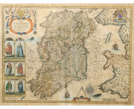
Lot 697
SPEED (JOHN), THE KINGDOME OF IRLAND DEVIDED INTO SEVERALL PROVINCES AND THEN AGAINE DEVIDED INTO COUNTIES NEWLY DESCRIBED, published Thomas Bassett & Richard Chiswell, hand coloured engraved map, six engraved costumed figures, ornate cartouche, mileage scale and compass rose, English text on verso. 42.5cm by 55cm

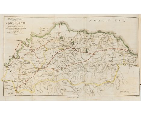
![Archer [J], coloured engraving, map of 'Westmoreland' from Dugdales and a 19th century map of Cumberland](https://cdn.globalauctionplatform.com/64a70903-b678-4794-ab5c-ab96009d50f4/2b3cfa87-3575-4e46-b2c2-ab9c0099777c/468x382.jpg)


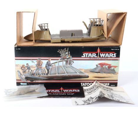
Lot 182
Scarce Vintage Boxed Kenner Star Wars The Power of The Force Tatooine Skiff Vehicle, No 71540, in mint original condition, complete with 2 x rudders,2 x side rails, missing decal sheet, decals have not been applied, instruction leaflet, planetary map, with inner card packing, outer box is good, one end flap sellotaped closed, with some edge wear/creases, still a very nice example!


Lot 1107
7x items of railwayana. A steel and cast iron cylindrical railway ticket punch machine painted green with plaque to top stamped A994. A small BR enamelled Distant semaphore signal (length 410mm). A British Railways enamelled armband, numbered 284. A Southern Railway wheel tapper's hammer. A section of Thanet Tramways rail. A cast iron plate numbered 325. Plus a framed map of the LSWR system. Generally GC for age. £60-80


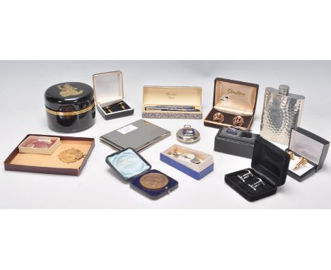
Lot 241
A collection of vintage gentleman's items to include a boxed blue celluloid Burnham London fountain pen pen set, a pair of rolled gold cufflinks, a cigarette case, a hammered decoration hip flask, a combined map measure and compass, a Bristol Education committee medallion and a a Victorian Bristol commemorative medal etc.


Lot 116
Antique Maps - including two Middle Eastern maps, Sidney Hall 'Palestine' published by Longman Rees Orme Brown & Green approx 49 x 57 cms framed and glazed; an antique uncoloured map of the ancient Middle East entitled 'Mappa Dispersus Filiorum Noemi' approx 25 x 36 cms as seen in the Atlas Encyclopedique 1787 and a third small map plate 223 entitled De L'Afrique showing Nubia, Abyssinia, Egypt and Ethiopia, hand coloured approx 11 x 17 cms, framed and glazed. (3)

Lot 115
Antique Maps - including Britannia plate 37 strip road map, from London to Carlisle, via Darlaston, Newcastle, Brewerton, Holmes Chapel, Lostock Graham, Great Budworth, Whitley, Streeton, Warrington, Newton-le-Willows, Wigan, Standish, Charnock Richard, Leyland, Preston with decorative centered cartouche with figures and cattle, uncoloured, approx 44 x 35 cms, framed and glazed, Thomas Gardner plate 40 strip road map, Road from London to Darby via Stony-Stratford, Grafton, Northampton, Brickworth, Haverborough, Great Glenn, Leicester, Mountforell, Loughborough, Kegworth, Darby with some colouring approx 28.5 x 18.5 cms. (2)

Lot 109
John Speede Map of Hartfordshire - uncoloured, Hartford shire described the situations at Hartford and the most ancient town of St Albans with such memorable actions as have happened, with key and corner vignettes, approx 54 x 41 h cms, framed and glazed together with another hand coloured map of Hartfordshire published 1798 by J. Stockdale, approx 51 x 41 cms, framed and glazed. (2)


Lot 368
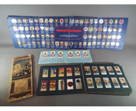
1966 Football World Cup Ladies Headscarves: Two different in excellent condition. One has 1966 World Cup to middle with players in different kits and the 16 teams named. The other has the flags of the 16 teams with World Cup Willie, Venues on a map and the emblem of the 66 World Cup in a Union Jack. (2)


Lot 110
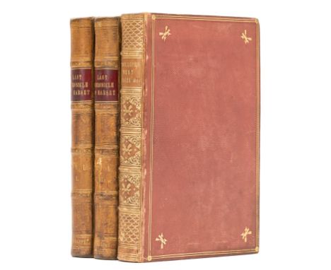
Trollope (Anthony) The Last Chronicle of Barset, 2 vol., first edition in book form, wood-engraved plates and illustrations by George H.Thomas, light foxing, bookplate of Rev. Prebendary Hedgeland, contemporary half calf, 1867; The West Indies and the Spanish Main, first edition, hand-coloured map frontispiece, light spotting at beginning and end, contemporary diced calf, gilt, spine gilt, g.e., spine slightly faded, 1859, a little rubbed, [Wolff 6784 & 6800], 8vo (3)
![Royal Navy.- Malcolm (George John, Rear-Admiral, 1830-84) Log of the Proceedings of H... M... S... Curacoa... [&] A Log o](https://cdn.globalauctionplatform.com/617e85a2-abc5-41d1-97ac-ab6e00a6bdf6/6905b4f0-bb38-4ad6-8114-ab6f00a1b579/468x382.jpg)
Lot 64
Royal Navy.- Malcolm (George John, Rear-Admiral, 1830-84) Log of the Proceedings of H... M... S... Curacoa... [&] A Log of the proceedings of H... M... S... Fisgard, autograph manuscript, titles and c. 240pp. (25pp. loosely inserted at end), numerous pen and ink sketches (including a watercolour of "Admiralty Rudder") and maps (including a map of Rio de Janeiro), 1f. torn out at end, some staining, slightly browned, original half calf, rubbed, folio, 1846-49.⁂ Places visited include: South America (Sugar Loaf Mountain, Rio de Janeiro entrance), west coast of Africa, "Track of Sir Charles Napier's Experimental Squadron August 1842" off the coast of Ireland.Malcolm was the eldest son of Sir Charles Malcolm (1782-1851), naval officer. He followed in his father's footsteps, serving in the Royal Navy for his entire career and becoming Rear Admiral in 1882. His long naval career took him to North and South America, the West Indies, the Baltic, the English Channel, Egypt, and the East Coast of Africa. After he retired from active service in 1873, he entered the Turkish services as Pasha and was employed at Constantinople as Director General of the Abolition of the Slave Trade and Judge of the Slave Courts.
Lot 77
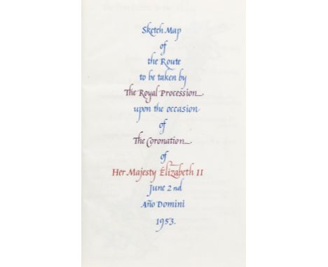
Coronation of Elizabeth II.- Gardner (Anthony, bookbinder, calligrapher and engraver, 1887-1973) Sketch Map of the Route to be taken by The Royal Procession upon the occasion of The Coronation of Her Majesty Elizabeth II..., calligraphic manuscript with 7 full-page watercolours of the processional route, title and 8pp., calligraphy in blue and red ink, binding no. 384 lettered on lower endpaper, bound in full grey crushed morocco, oval brown morocco inlays with gilt monogram "ER II" stamped on upper cover, gilt Tudor roses and single line gilt borders in corners, gilt fleur-de-lys stamped on spines, g.e., 8vo, calligraphic spiral apologia by Gardner at end, "sketched and bound by for Her Majesty's Minister of Works for the gracious use of her Majesty during her Coronation procession, by Anthony Gardner...", 1953. ⁂ Anthony Gardner was Chief Structural Engineer in the Ministry of Works until his retirement in 1953. Following his retirement, Gardener established his own bookbinding and restoration firm.
![Bible, English. [The Holie Bible, Bishop's version], 2 vol., black letter, double column, woodcut illustrations, maps and ini](https://cdn.globalauctionplatform.com/617e85a2-abc5-41d1-97ac-ab6e00a6bdf6/336da8d0-ab9f-4775-90d6-ab6f00a19e9f/468x382.jpg)
Lot 78
Bible, English. [The Holie Bible, Bishop's version], 2 vol., black letter, double column, woodcut illustrations, maps and initials, divisional titles to parts 2 and 3 with the engraved portraits of the Earl of Leicester and Lord Burghley, lacking engrave map of Canaan and c.37 of 732ff. (all before *3, including general title, 15 leaves of preliminaries; P7, Q-R8, S4 lacking from New Testament), several ff. repaired with loss (many somewhat crudely), occasional browning or soiling, 19th century calf-backed boards, rather worn, [Herbert 132], folio, [By Richarde Jugge], [1572]; sold not subject to return. ⁂ The second folio edition of the Bishops' Bible, almost always found incomplete, this copy better than most. " A remarkable feature of this edition is its two-version Psalter, which exhibits, printed side by side, (1) The translation used in common prayer (taken originally from the Great Bible, and still retained in the Prayer Book) in black-letter, and (2) The translation after the Hebrewes (i.e. the Bishops' version) in roman type." - Herbert. A grand 16th-century black letter printing on strong paper, one of the most beautiful printings of the English bible.


Lot 670
An impressive large 19th Century Victorian antique pitch pine ships map / chart table having a long flared table top with gallery backed edge. The table being raised on six block and turned legs with cylindrical stretchers and steel feet. The Steel feet with fixing holes for securing the table. Markings for VR to the underside in many places. Measures; 62cm x 299cm x 64cm.

Lot 189
NO RESERVE Worcestershire.- Green (Valentine) A Survey of the City of Worcester, first edition, folding engraved plan and 15 plates, some folding, list of subscribers, occasional foxing, contemporary calf, rebacked, rubbed, Worcester, by J. Butler for S. Gamidge, 1764 § Bentley's History, Guide...Worcestershire, 3 vol. (only) in 1, folding map, engraved advertisements, contemporary calf, rebacked, Birmingham, c.1840 § Smith (William Hawkes) Dudley Castle. An Historical and Descriptive Account, 9 engraved plates, original boards with glazed printed label, rebacked in cloth, rubbed, London & Birmingham, 1836; and 10 others, Worcestershire, v.s. (13)
Lot 190
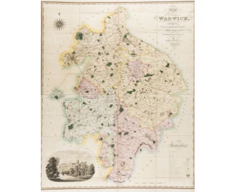
Warwickshire.- Greenwood (C. & J.) Map of the County of Warwick from actual Survey made in the years 1820 & 1821, large calligraphic title, table of explanation, compass rose and vignette of Warwick castle in the lower left, engraving with original hand-colouring, 1320 x 1050 mm. (52 x 41 1/4 in), dissected and mounted on linen, light offsetting, minor browning and surface dirt, edged with blue linen and folding with marbled ends, contemporary tree calf book-style case, tooled in blind, worn label to spine, rubbed and slightly worn, 1822.

Lot 199
NO RESERVE Italy.- Hamilton (Sir William) Observations on Mount Vesuvius, Mount Etna, and other Volcanos: In a series of letters, addressed to the Royal Society, 5 engraved plates and folding engraved map, map torn without loss, title stained at head, occasional spotting, contemporary calf, rebacked, corners worn, rubbed, Printed for T. Cadell, 1774; and Troil on Iceland, 1780, 8vo (2)
Lot 236
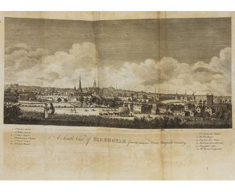
NO RESERVE Birmingham.- Hutton (William) An History of Birmingham, second edition, 20 engraved plates and maps, some folding, contemporary tree calf, rebacked, Birmingham, by and for Pearson and Rollason, 1783 § Riots at Birmingham (The), reprint of original 1792 edition, 8 tinted lithograph plates, one text leaf torn, library morocco-backed cloth, Birmingham, 1863 § Morfitt (J.) An Abstract of all the Acts of Parliament that relate to the Town of Birmingham, and Hamlet of Deritend, contemporary sheep, worn, Birmingham, Printed by E. Jones, 1791 § Curtis (Rev. Charles) A Sequel to the Printed Paper lately circulated in Warwickshire, 1792; bound with [Parr (Samuel)] A Letter from Irenopolis...to the Dissenters of Birmingham, half-title, Birmingham, 1792; and [Cumberland (Richard)] Curtius rescued from the Gulph..., half-title, 1792, together 3 works in 1, contemporary calf-backed boards with vellum corners, joints split, rubbed § Jobbins (J.R.) Birmingham and its Environs, engraved map, folding in sections and mounted on linen, partial hand-colouring, folding into original cloth covers, but one cover detached, 557 x 695mm., 1838; and 26 others, Birmingham, v.s. (31)
Lot 237
Britain.- Hutton (William) A Trip to Coatham, a Watering Place in the North Extremity of Yorkshire, first edition, engraved portrait frontispiece, folding map with outline hand-colouring, 3 plates, slight offsetting, library half morocco, 1810; The History of Derby, first edition, folding engraved frontispiece, folding plan and 17 plates, library half morocco, 1791 § Aikin (Arthur) Journal of a Tour through North Wales and part of Shropshire with Observations in Mineralogy..., engraved portrait from another work bound in as frontispiece, ink ownership inscription of Daniel Jones, Donington 1869 and with his ink annotations, especially relating to geology towards end, contemporary half calf, worn, rebacked, 1797 § Moritz (Karl P.) Travels, Chiefly on Foot, through several parts of England, first edition, translated by 'A Lady' [probably a daughter of Charles Godfrey Woide], contemporary calf, worn, 1795 § Bingley (Rev. William) A Tour round North Wales, 2 vol., 4 aquatint plates, engraved plates of musical notation, contemporary half calf, joints cracked, rubbed, 1800; and 47 others, British topography, v.s. (53)

Lot 283
Geology.- Mines.- Derbyshire.- Mawe (John) The Mineralogy of Derbyshire: With a Description of the Most Interesting Mines in the North of England, in Scotland, and in Wales, engraved frontispiece, map and 2 plates, offsetting, some creasing, occasional spotting, lightly browned, armorial bookplate of G. C. Greenwell, 19th century half calf over cloth, Greenwell's monogram to upper cover, upper joint split, head of spine and corners worn, rubbed, [Hoover 569], Printed and sold by William Phillips, 1802; and 2 others, Mineral Laws of Derbyshire, 1734 and Mander's Derbyshire Miners' Glossary, Bakewell, 1821, in original printed boards, 8vo (3)
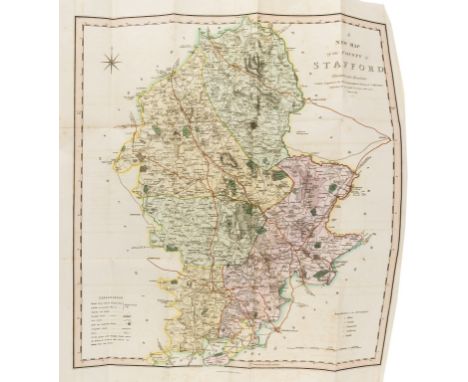
Lot 327
NO RESERVE Staffordshire.- Pitt (William) A Topographical History of Staffordshire, first edition, large folding hand-coloured map, list of subscribers, later half morocco, spine and joints worn, Newcastle-under-Lyme, 1817 § South Staffordshire Industrial & Fine Arts Exhibition, Molineux House, Wolverhampton, second edition, 4 parts in 1, 2 mounted photographic plates, original roan-backed printed boards, rubbed, Wolverhampton, 1869 § Pearce (Thomas) The History and Directory of Walsall, folding engraved frontispiece, one leaf torn, uncut in original printed boards, rubbed and soiled, rebacked, Birmingham, 1813; and 16 others, Staffordshire, 4to and 8vo (19)
Lot 333
Staffordshire.- Plot (Robert) The Natural History of Stafford-shire, first edition, title with engraved vignette, folding map laid down, 37 plates, most double-page and/or folding, one with short tear, a couple repaired, without the rare "Armes omitted" plate as often, 2ff. list of subscribers at end slightly cropped at lower edge with some loss of text, occasional soiling, later library half calf, [Wing P2588], Oxford, Printed at the Theater, 1686.⁂ Subscribers include Robert Boyle, Narcissus Lutt[e]rell and Elias Ashmole.
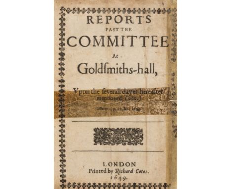
Lot 353
NO RESERVE Reports past the Committee at Goldsmiths-hall, first edition, first 3ff. crudely repaired with tape, additional leaves paginated 13-30 at end, not called for by ESTC, modern half calf, [Wing E2232A; ESTC R206360 locates 7 copies in UK and none in N. America], by Richard Cotes, 1649 § Alldridge (J.) The Goldsmith's Repository, half-title repaired at outer margin to verso, folding table, library calf-backed cloth, 1789 § His Majesties Gracious Patent to the Goldsmiths, For Payment and Satisfaction of their Debt, later half calf, joints cracked, rubbed, [Wing C3039], by John Bill, Christopher Barker, Thomas Newcomb and Henry Hills, 1677 § Ward (James) A History of Gold, frontispiece, folding hand-coloured geological map of Victoria and New South Wales slightly frayed at fore-edge, later half morocco, London & Dublin, n.d.; and 71 others on Gold and Silver testing, weights and measures, hall-marking etc., v.s. (75)

Lot 455
Warwickshire.- Yates & Son (William) A Map of Warwickshire drawn from an actual survey taken in the years 1787-1788-1789, county map centred on Warwick with vignette of Warwick Castle and St Mary's Tower in the lower left, engraving, 1370 x 1065 mm. (54 x 42 in), dissected and mounted on linen, some scattered spotting and surface dirt, pencil inscriptions, folding into modern slipcase, 4to, John Sharp, 1793⁂ Scarce large-scale survey. John Sharp, the publisher of the map, was a bookseller in the High Street, Warwick.

Lot 56
NO RESERVE Warwickshire.- Bisset (J.) A Descriptive Guide of Leamington Priors, first edition, 9 engraved plates, one folding, one repaired, some foxing and browning, contemporary half calf, spine faded, extremities worn, Coventry, for the Author, 1814; another copy, second edition, engraved map and 10 plates, mostly trade advertisements, library half morocco, Coventry, 1816 § Jaffray (James) Graphic Illustrations of Warwickshire, engraved frontispiece and 30 plates (of 31), vignettes, some browning, library morocco-backed cloth, Birmingham, 1862 § Smith (William) A New & Compendious History of the County of Warwick, engraved map, vignette-title and 60 plates, foxed and browned, contemporary half calf, rebacked preserving original spine, Birmingham, 1830; and 26 others, Warwickshire, v.s. (30)

Lot 58
NO RESERVE Russia.- Bobrinskii (Count Alexei) Kurgani i Sluchainiya Arkheologicheskiya Nakhodki bliz Mestechka Smeli [Burial mounds and fortuitous archaeological discoveries near Smiela], 2 vol., text in Russian, 4 folding maps and 55 plates, mostly lithographed, 10 chromolithographed and heightened with gold and/or silver, 2 folding, contemporary library half roan, original printed wrappers bound in, rubbed and scuffed, St. Petersburg, V.S. Balashev, 1887-94 § Tooke (William) View of the Russian Empire, 3 vol., second edition, folding engraved map, spotting, later half roan, 1800; and 3 others on Russian art, some with chromolithographs, 4to & 8vo (8) ⁂ Bobrinskii was head of the Imperial Archaeological Commission from 1886 to 1917 and his collection is now part of the Hermitage.
Lot 63
NO RESERVE Cornwall.- Borlase (William) The Natural History of Cornwall, first edition, folding engraved map with short tear at fold, 28 engraved plates, errata leaf at end, list of subscribers, some foxing and browning, especially to last few leaves, contemporary mottled calf, gilt, rebacked, extremities worn, folio, Oxford, for the Author, 1758.⁂ A comprehensive account covering the climate, geography, flora, fauna, minerals and mining for tin, iron, copper, silver, lead and gold.
Lot 90
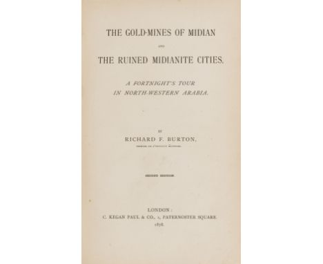
Gold-mining.- Burton (Richard F.) The Gold-Mines of Midian and the Ruined Midianite Cities, second edition, half-title, folding map, advertisements at end, original cloth, soiled, spine ends worn, 1878 § Earp (G. Butler) The Gold Colonies of Australia, and Gold Seeker's Manual, folding map, contemporary half morocco, spine faded, 1852 § Mackenzie (Rev. David) The Gold Digger, folding map with outline hand-colouring, later half morocco, [c.1853] § Goldmann (Charles Sydney) South African Mines, 3 vol., vol.3 with 99 colour plans, many folding, one with tear, some slight dust-soiling, original cloth, spines faded, covers sunned, London & Johannesburg, 1895-96; and 4 others gold-mining, 4to and 8vo (10)


Lot 669
BATES HENRY WALTER: (1825-1892) English Explorer & Naturalist who gave the first scientific account of mimicry in animals. Bates is also famous for his expedition to the rainforests of the Amazon with Alfred Russel Wallace. A.L.S., H W Bates, three pages, 8vo, Savile Row, Burlington Gardens, London, 10th January 1878, to Carruthers, on the printed stationery of the Royal Geographical Society. Bates announces 'I have not the power to purchase the Mungo Park sketches right off' and explains 'They must be submitted to our Regular Map & Library Committee, which will not meet before the 23rd', further adding 'I cannot gather from your letter whether we may retain them or not till that day' and also remarking 'There is only slight hope that the Committee will have them'. A few spots of foxing and some light traces of former mounting to the verso, otherwise VG £100-150 Mungo Park (1771-1806) Scottish Explorer of West Africa.
Lot 745
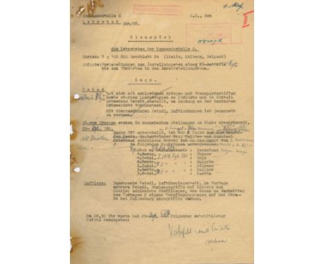
V-2 ROCKET: A small archive or original typed documents (some carbon copies, others mimeographed) relating to Nazi Germany's development of the V-2 rocket, the world's first long-range guided ballistic missile, thirty pages, mainly 4to, n.p. (Headquarters S), October 1944 - January 1945, some stamped as Top Secret, in German. 'Accompanied by a complete English translation' . The documents include Test Reports containing various technical data relating to trials of vertical launches to 65 km in clear skies ('for observation and filming of possible in-flight break-up during ascent phase), trials of accelerometers, pyrotechnic ignition, generator batteries and fibreglass protection, further detailing results and observations including the application of new non-flammable yellow paint to aid visual tracking, satisfactory control and radio systems etc., concluding that the 'device cleared for firing' and in another test stating that the rocket had insufficient thrust and after 155 seconds of flight it was 'seen to fall into a transverse altitude' and at 210 seconds (approximately 52 km altitude) the rocket oscillated severely, turning 'into a narrow corkscrew-like twisting motion' and that, at about the same time, 'the yellow paint began to turn a sludgy brown' and at 271 seconds the rocket was 'no longer behaving abnormally' and 'exploded in bright flames'; a summary of a Rocket School's training stating, in part, 'There being no experience in deployment of the A4 [the technical name of the V-2, i.e. Aggregat 4] and the technology being highly advanced, the training was at first purely technical in conception. At HAP 11 [Heimat Artillery Park 11, Karlshagen, Pomerania] it was done in such a way that the engineers working there also acted as teachers on a first course that trained specialists for the first launch batteries' further stating that the original plan could not be implemented because a concentration of specialist rocket force manpower at HAP 11 was undesirable on account of the possibility of aerial attack and therefore the Headquarters were moved to Koszalin, providing a table of organisation to include administrative staff, specialists including a counterespionage officer, guard platoon troops, armourers, orderlies, cooks and instructors etc., and concluding 'the staffing envisaged is necessary for the provision of the courses…..special importance is accorded to training the rising generation as officers, NCOs and men for the rocket forces. Any reduction in the establishment here proposed would endanger the success of the planned training'; a Map Exercise prepared by Education Staff in preparation for the deployment of a long-range rocket and detailing the enemy's situation as having 'assembled strong land forces in Southern Sweden with numerous warships and transports off the south coast, in preparation for landing on German Baltic coast' and the enemy's air situation as growing in superiority with heavy bomb attacks on Kolberg and Koszalin and 'many low-flying planes which….have attacked two of our supply trucks'; and a Field Report statement by Specialist Officer Metzler, dated 20th January 1945 and stating, in part, 'The undersigned was posted on attachment to Techn. Combat Unit, Commissioner for Special Assignment (Army) at the start of the deployment of the V-2 weapon in early September 1944….where he provided engineering services until the termination of the attachment in mid-January 1945…..The undersigned joined the battery at Haarzuilens…..the firing position was located in a suburb of Den Haag, where the battery executed the double launch that fired the first two rockets on London. The battery was withdrawn from Holland in mid-September on account of the English airborne landing at Arnhem, moving to a firing position…..of Westphalia to bombard targets Liege and Antwerp…..Firing suffered at first from the well-known teething problems. Supply left much to be desired……as a result, firing operations were at first very slow…..Night operations were particularly inefficient…..With systematic training, manning changes and exercises, firing operations have now been brought to a very high level of competence…..The normal time to prepare a device for firing, from the start to launch, is on average around 90 minutes……Firing was in general hardly affected by enemy action, though some delays to work and firing on account of the presence of enemy aircraft had to be accepted. During deployment in Holland, the firing position only once suffered a daylight attack by low flying planes using on-board armament….Changes of position were thus frequently ordered while deployed in Holland. In Westphalia, whose landscape is dotted with many wooded copses, no change of position proved necessary. The battery fired for two months from the same position without ever being discovered by the frequent spotter planes', continuing to detail various problems and difficulties in the launches of V-2 rockets including the failure of the Volkswagen motor in starting, inadequate power supply, loose fitting valves and pumps, leaks, incorrect or incomplete wiring systems, faulty circuits, combustion chamber explosions etc., and also commenting on training 'Observation of a well-functioning firing platoon reveals that the steps of the launch operation follow each other like clockwork…..the whole platoon being fused together into a single working unit in which each individual does what is necessary for the rapid execution of the operation, either on his own initiative or at most in response to a codeword…..' Some of the documents bear pencil and ink annotations and corrections. Some extensive age wear, including tears, areas of paper loss, staining and some evidence of singing caused by previous fire damage. Only FR, Qty. £3000-4000
![[FOY - HERNANI]: An excellent military map of Hernani, issued by French Napoleon´s army, one page, oblong large 16 x 12 folio](https://cdn.globalauctionplatform.com/3d1efb42-d105-4f52-beb8-ab6c01265f3c/f8f0defd-b690-43f7-bb64-ab6d00b9b2dc/468x382.jpg)
Lot 1023
[FOY - HERNANI]: An excellent military map of Hernani, issued by French Napoleon´s army, one page, oblong large 16 x 12 folio, Hernani, 26th June 1813, with annotations in French. The map is issued, fulfilling orders given by General Foy, on his retreat from Spain, Maximilien Sebastien Foy (1775-1825) French military leader. The very attractive map, ink drawn, shows the city, rivers around, bridges, a scale at the base, etc.. To the left border, a lengthy eight lines annotation in bold black ink, signed by `Bure´, reporting on the best military locations where to post the regiments and better protect their army during the retreat, stating in part `The position before the Astigaraza bridge is surrounded by too much coppice and do not grant enough obstacles as the one before Hernani, where the army will be able to lean on both sides of the river…´ Small overall minor age wear and staining, with edges slightly trimmed, otherwise G £120-180 On 20th June 1813 Foy issued orders to evacuate Bilbao. On 21th June, French forces set off at dawn from Vitoria, escorting a large convoy towards the French frontier, while Wellington's army inflicted a decisive defeat on Joseph's Bonaparte troops at the Battle of Vitoria. On 26th June took place the Battle of Tolosa, and the British-Portuguese-Spanish forces began the siege of Pamplona. Thomas Graham forces cut of Foy´s retreat. The next day, Foy, threatened with envelopment decided to retreat to Hernani with his corps numbered 16,000 infantry, 400 cavalry and 10 field pieces. Foy had ordered the day before to issue the present map, planning his retreat. Hernani is a town located in the province of Gipuzkoa, Spain, at a distance of nine km from San Sebastian. The title character of Victor Hugo´s play Hernani is named after the town.
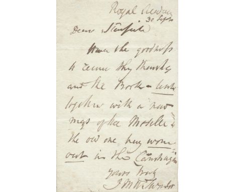
Lot 390
TURNER J. M. W.: (1775-1851) English Painter. A.L.S., J M W Turner, one page, 8vo, Royal Academy, (London), 30th September n.y., to Stanfield. Turner writes, in part, 'Have the goodness to receive thy thanks and the Book - lent together with a new map of the Moselle. The old one very worn out…..' VG £600-800 Turner's correspondent is likely to have been Clarkson Frederick Stanfield (1793-1867) English Marine Painter who, in 1838, published a collection of lithographic views on the Moselle, Rhine and Meuse rivers.


Lot 366
Schneider Trophy Contest 1929 The Royal Aero Club Souvenir Programme - 52 page programme full of photographs, including two full colour plates. Also map of the course and extensive details of the intended races. Multicoloured attractive Art Deco front cover. Size 7¼"x 9¾". Good Condition. All autographs are genuine hand signed and come with a Certificate of Authenticity. We combine postage on multiple winning lots and can ship worldwide. UK postage from £4.99, EU from £6.99, Rest of World from £8.99.

Lot 367
Schneider Trophy Contest 1931 The Royal Aero Club Souvenir Programme - 52 page programme full of photographs, including two full colour plates. Also map of the course and extensive details of the intended races. Multicoloured attractive Art Deco front cover. Size 7¼"x 9¾". Good Condition. All autographs are genuine hand signed and come with a Certificate of Authenticity. We combine postage on multiple winning lots and can ship worldwide. UK postage from £4.99, EU from £6.99, Rest of World from £8.99.
-
109198 item(s)/page