We found 109182 price guide item(s) matching your search
There are 109182 lots that match your search criteria. Subscribe now to get instant access to the full price guide service.
Click here to subscribe- List
- Grid
-
109182 item(s)/page


Lot 12
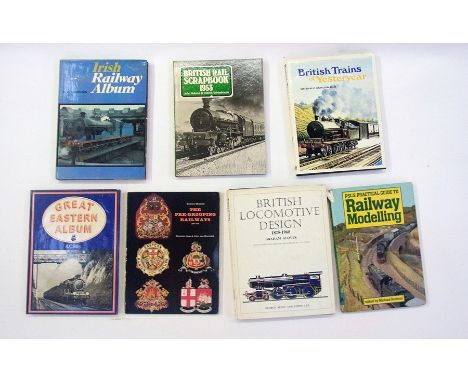
A large quantity of books relating to railways including:- The Irish Railway Album, Lancashire and Yorkshire Album, Great Central Memories, The British Steam Railway Locomotive, Britain's Railway Magazines, Forgotten Railways, British Railway Map and Gazetteer and Historic Locomotive drawings in 4mm scale drawn by F. J. Roch (1 box)


Lot 13
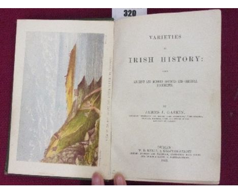
1759 AD. A printed map of Ireland designed by R.W. Seale with the legend A Map of the Kingdom of Ireland from ye latest & best Observations. For Mr. Tindal's Continuation of Mr. Rapin's History; mounted in an unglazed frame. 580 grams, 55 x 45cm (21 1/2 x 17 1/2"). Ex Walter Steinberg collection; acquired London art market, 1960s-1970s. The Reverend Nicolas Tindal (1687-27 June 1774) was the translator and continuer of the History of England by Paul de Rapin, covering the period from the reigns of James II to George II. The Continuation was published in 1759 AD in three volumes and Tindal was rewarded with a gold medal by Frederick, Prince of Wales, to whom he had decicated the second volume of the work. Walter Steinberg has been a well-known figure at fairs, sales and events for many years. Born in 1922 in Philadelphia, Walter has had a life-long passion for collecting. A long-time resident in London, he has now retired to New York and decided that the time has come to pass on the antiquities and coins he has collected over his lifetime. Walter acquired coins and artefacts that interested him, so his collection, although containing many lovely examples, also contains many affordable specimens. Much of the material has been unavailable to the market for 30 to 50 years. Walter hopes that the items he collected will now find new homes with the next generation of collectors. [No Reserve] Fine condition, small tear to one crease.


Lot 295
Three 18c road maps, framed and glazed, comprising Senex Road Maps 1719-1775, a double sided from the 1762 atlas, the road from Chester to Cardiff in Glamorganshire containing a table of distances from Chester, a copy double sided from Bowen & Owen Atlas 1720-1764 Chester to Cardiff including a map of Brecknockshire and from the third issue of Carrington Bowles Post-Chaise Companion 1782 Chester to Cardiff and Shewsbury to Chester.


Lot 2801
Burton, Captain Sir R.F. Abeokuta and the Cameroon Mountains. An Exploration, 2 volumes, first edition, 4 plates only, without half-titles, portrait and folding map, pp.284-290 in volume one with margins chipped, some spotting and browning, original cloth, spines slightly chipped at ends, 8vo, London: Tinsley Brothers, 1863 [Penzer, p.70]
Lot 2940
Hunting Map. A large folding lithographed map of central Sussex, with an index key of the meets for the Crawley and Horsham Hunt and Lord Leconfield's Hunt, 18 sections backed on linen, 6 inches to the mile, the River Arun with later colouring, in cloth folio, but extending to 1380 x 1830mm, [c. 1880]
Lot 2942
London Passenger Transport Map. A large folding map depicting the metropolitan rail network, c.1933, one inch to the mile, the railways hand-coloured, in 48 sections, backed onto linen, but extending to 169 x 216 cm, in cloth portfolio, Ordnance Survey, 1933 This map would appear to mark the birth of the London Passenger Transport Board in 1933.

Lot 2948
Stanford, Edward. A Map of England and Wales, divided into Counties, Parliamentary Divisions and Dioceses shewing the Principal Roads, Railways, Rivers and Canals and the Seats of the Nobility and Gentry with the Distance of each Town from the General Post Office, London... drawn by R. Creighton, engraved by J. Dower, hand-coloured lithographed map in 120 sections over 4 sheets, folded and backed on linen, five miles to one inch, in original leather case, w.a.f., London: Ordnance Survey, 1866
Lot 2541
Coker, John. A Survey of Dorsetshire. Containing the Antiquities and Natural History of that County, first edition, folding engraved map, 6 engraved plates of crests, somewhat waterstained, contemporary calf, neatly rebacked, bookplate of William Belchier, folio, London: J. Wilcox, 1732 [Upcott, p.173]
Lot 2547
Lander, William. Lander's Electoral District Map of the City and County of Bristol, hand-coloured engraved map in 18 sections, folded and backed onto linen in cloth case, 500 x 610mm extended, Bristol, c.1840; and a small quantity of Somerset ephemera, including newspapers, a cheque book from Mess. Stuckley and Company, Langport, and a pamphlet concerning friendly societies, printed in Wells (a small quantity)
-
109182 item(s)/page