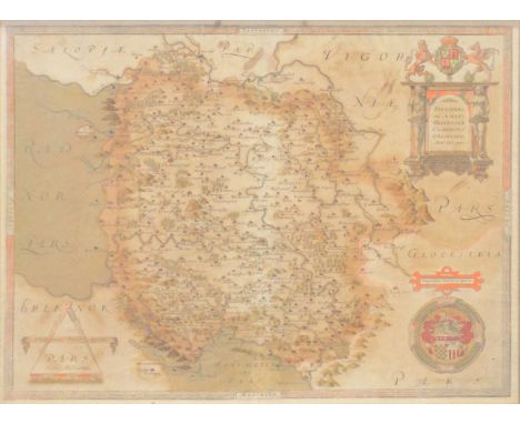

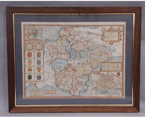
Christopher Saxton, Herefordshire, hand-coloured county map somewhat discoloured, and creased, visible 38.5x51.5cm.Condition report:Historic repair down the centre, with evident tears existing at the bottom margin, affecting the MERIDIES and surrounding area. Tape backing to stabilise the tears evident verso. A historic crease line running diagonally from the lower margin below the encircled HEREFORDIA, running up through the county to the top margin almost running through Ludlow. Other creases elsewhere but none as lengthy. The plate mark is not obvious, so it may have been trimmed very close and hidden behind the existing frame. Bunch of grapes watermark is present. Gallery label for PJ Radford, Denmead, nr Portsmouth, Hants, and pencil written notes presumably from that trade.
We found 109182 price guide item(s) matching your search
There are 109182 lots that match your search criteria. Subscribe now to get instant access to the full price guide service.
Click here to subscribe- List
- Grid
-
109182 item(s)/page


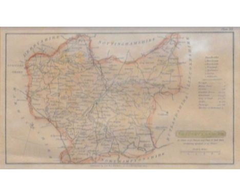
John Prior, Map of Leicestershire from an actual survey ... finished in the year 1777, large format, on four sheets, published 1779, each sheet approximately 56.5x61cm.Condition report:Believed cut from originally being a single sheet and relined. The top two quarters are about 1cm shorter in height than the bottom two. The margins where the quarters meet appear cut and there is a slight loss to the map detailing where they have been trimmed. All four sheets have subsequently been folded vertically. Unframed, unmounted. Heavy discolouring to the top half of the top two quarters and historic creases.


Emanuel Bowen, An Accurate Map of the Counties of Leicester and Rutland, divided into their respective hundreds, a hand-coloured county map, folded, 54x71cm; John Harrison, A Map of Leicester & Rutland, engraved from an acutual survey with improvements, hand-coloured county map; Thomas Bowen, Leiceter and Rutland; together with Bowle's New Medium Map of Leicester and Rutland, all unframed.Qty: 4
Robert Morden, Leicester Shire, hand-coloured county map, 37x41cm; John Ogilby, The Road from London to Darby, ribbon map; John Cary, Leicestershire; G & W B Whittaker, Leicestershire; Plan of Leicester; an engraved print, "Leicestershire" together with two framed extracts from Nichols, Leicestershire.Qty: 8


Ray Wilson bronze European Nations Cup Third Place Winner's medal, 1968 the obverse cast with a map of Europe and a football, the reverse inscribed UEFA, Championnat d'Europe, 1968, III e Rang, with ribbon, in original fitted case The above medal was awarded to Ray Wilson, in the match played on 8th June 1968 in Rome, England defeated the USSR 2-0 to win the 3rd and 4th place play-off. Bobby Charlton opened the scoring in the 39th minute and Geoff Hurst doubled England's tally in the 63rd minute


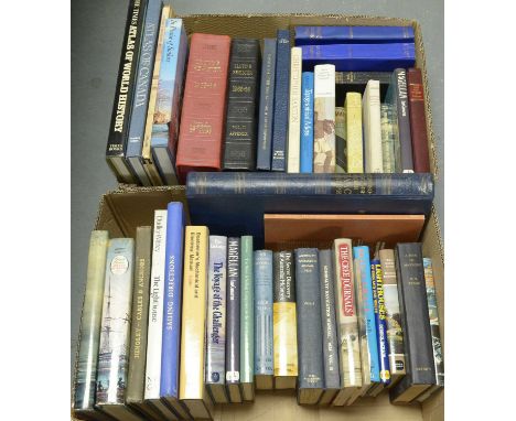
A selection of hardback and other books, primarily relating to sailing and cartography, titles including: Magellan, by Ian Cameron; Maps, by Alexander D’Acapeyeff and E. C. R. Hadfield; A Book of Discovery, by M. B. Synge; The Voyage of the Challenger, by Eric Linklater; Maps and Map Makers, by R. V. Tooley; The Early Maps of Scotland, by D. G. Moir and The Royal Scottish Geographical Society; and others, contained across two boxes.
Georgian manuscript map card game. A unique set of handmade educational cards, c. 1800, produced entirely in ink & watercolour (not etched or engraved), a teaching aid or parlour game comprising a total of 94 cards arranged in the following order: 40 cards depicting maps of the English counties in a variety of vibrant colours, each county with an accompanying manuscript information card; two cards depicting the counties of North Wales & South Wales with 12 corresponding information cards. The cards measure 112mm by 76mm. Very well-preserved, clean and bright. Housed in a later buckram clamshell box lined with marbled paper and evidently created specifically to fit the set of cards perfectly

Africa. Arrowsmith, Aaron. A large and historically important map of Africa, 1 November 1802, copper-engraving, dissected into 24 sections, linen-backed, approx. 125cm by 145cm, dedicated 'To The Committee and Members of the British Association for Discovering the Interior parts of Africa', featuring an allegorical cartouche at lower-left. The map has toning, staining & marks, a few very small areas of loss but avoiding the engraved detail, the warm colour is not unattractive This map has been described as "one of the greatest maps ever published. Arrowsmith simply stripped away centuries of accumulated myth, misconception and unsustainable guesswork, and took the mapping of Africa back to the bare bones of substantiated fact, leaving the interior as a blank canvas, a challenge to a new generation of explorers. As a picture, many of his predecessors of a century earlier would not have thought of publishing it, as a statement of intent it raised the standard for geographical accuracy above that practised by the vast majority of his contemporaries" [Mapforum #5, Stanford Libraries]


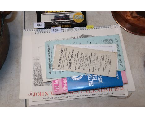
Three John Western Suffolk calendars 1975, 1976 and 1981. Ernest R Cooper, 'Mardles from Suffolk, A Taste of East Anglian Humour', a 'Third Annual Vintage Auction Catalogue Suffolk Show 1971', 'Map Routes of Eastern Counties Omnibus', 'Wickham Market 'Particulars and Conditions of Sale' relating to Small Residence known as 88 High Street 1948, a Wickham Market District and Street Map and Wickham Market Cattle Market Advert for Sale Monday 4th August 1969


SIX VINTAGE MAPS comprising a possibly late 17th century- early 18th century map inscribed Provinces- Unies Des Pays-Bas auec leurs Aquisitions dans lea Flandre le Brabant Le Limbourg et le Lyege et les Places quelles possedoient surle Rhein, dans le Duche De Cleves, et dans L'Archevesche et Eslectorat De Cologne, Par le St Sanson, Geographe Ordinaire du Roy, a Map Of The Seven United Provinces With the Land Of Drent And The Generality Lands by W. Faden, Geographer To The King, 1794, an undated map of a part of N.E. Italy, an Admiralty map of the Gulf of Mexico, 1890, an undated, hand-coloured map of the Americas and a map of the South Coast of Italy published by the Admiralty, originally in 1882 but this revision is from 1936
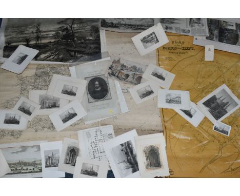
MAPS & PRINTS A selection comprising an 1828 hand coloured Map of the Parish of Whittington, an 1865 wall- hanging Plan of the Town of Burton upon Trent, an early 20th century wall-hanging Official Railway Map of England and Wales, prepared and published at the Railway Clearing House London for the Board of Trade (Controller of Coal Mines) a collection of early 18th century prints and book pages of Lichfield, a print of The Prince of Wales at Allsopp's Brewery, Burton-on-Trent, several Portrait etchings of William Shakespeare and a B.W. Leader etching (1 box)

6x Early motoring maps, some cloth. 3 x Michelin maps of the British isles circa 1916 -1920s, Manchester-York No11, Bristol – Carmarthen No 17, and Aberystwyth-Hereford No 15. 1x OS 1947 of Chester. 1x Bacons Country Map & Guide of Yorkshire Circa early 1900s. 1x AA Route guide and Tour planner from the 40’s/50s.

Four Michelin signs,each printed tin, comprising 1966 Map of England and Wales, 86 x 63cm; Michelin Tyres, (faded) 30.5 x 30.5cm, and two similarly designed signs for Tyres & Accessories and Service Bay each 27 x 57cm, the edges turned over for strength; together with a seated Mr Bibendum figure, on hinged metal mount, 46cm high. (5)Lot to be sold without reserve.For further information on this lot please visit Bonhams.com
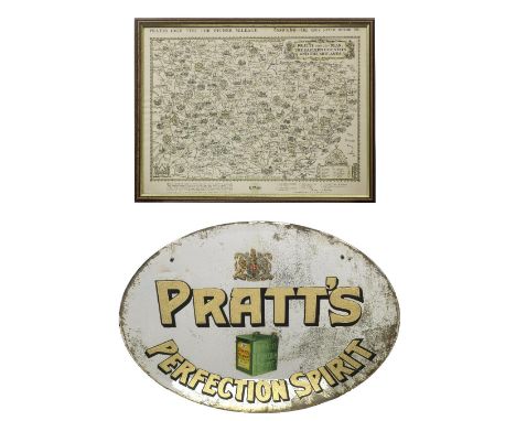
A 'Pratt's Perfection Spirit' mirror and a framed Pratt's map,the oval mirror with bevelled edge, with gilt-lettering, featuring image of a Pratt's petrol can and Royal Warrant emblem, some loss to silvering and with black paper backing, 46 x 58cm, lacking hanging chain; offered together with a Pratts High Test/Essolube pictorial map of the Eastern Counties and the Midlands, 50 x 38cm, framed and glazed. (2)Footnotes:This mirror and map (as well as lots 118 and 429) were displayed at the Great Yarmouth Motor Garage, 46 Northgate Street, Garfield House, Norfolk. The 1886 building was originally a builders' and stable yard and became repurposed as a garage by G.E. Sadler in the early 1900s, being one of the first garages in town to sell petrol, selling Pratts Motor Spirit from cans until Shell pumps were later installed. The garage was subsequently taken over by a Mr George Cooper in 1921 until 1969, then taken over by his son and eventually ceased trading upon his retirement in 1989.See lots 118 and 429 in this auction.Lot to be sold without reserve.This lot is subject to the following lot symbols: ◊◊◊◊ £60 + VAT uplift and storage at £12 + VAT per lot per dayFor further information on this lot please visit Bonhams.com

MEISSEN "Landkartenhändler" 20.Jh. Entwurf von P. Reinicke um 1744, polychrom staffierte Figur aus der Gruppe "Pariser Ausrufer", Schwertermarke, H: ca. 17 cm. Unbesch.| MEISSEN "Map Dealer" 20th century.Design by P. Reinicke circa 1744, polychrome painted figure from the group "Pariser Ausrufer", sword mark, h: approx. 17 cm. Uninspected.


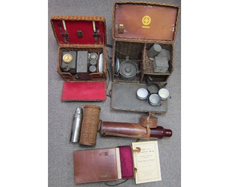
Two small wicker picnic sets,comprising a two person set with kettle and burner in basket with red lining; another by Drew & Sons, London, (incomplete); two vacuum flasks one in wicker case, another in leather case; together with a leather-cased map set for England and Wales, (condition and completeness unknown). (Qty)Lot to be sold without reserve.This lot is subject to the following lot symbols: † ◊† VAT at the prevailing rate on Hammer Price and Buyer's Premium.◊ £30 + VAT uplift and storage at £6 + VAT per lot per day.For further information on this lot please visit Bonhams.com

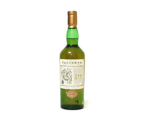
Miniature Whiskies: including Glenfarclas 105, Glenfarclas 10 Year Old, Laphroaig 10 Year Old, Bowmore 12 Year Old, Ardbeg 17 Year Old, Clynelish 14 Year Old Flaura and Fauna, BenNevis 1984, Lagavulin 16 Year Old (White Horse bottling), Talisker 10 Year Old (map bottling), James MacArthur set (Linkwood, Blair Athol, Glen Keith, Dufftown, Teaninich, Strathmill), and many others together with a small group of advertising tumblers and shot glasses, and four volumes on whisky (qty - 100+ miniatures)
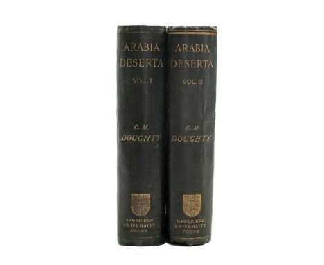
DOUGHTY (C.M), Arabia Deserta. 2 vols, FIRST EDITION, folding plates, illustrations, folding colour map in pocket at end of vol.1, original dark green clothbound, decorative gilt cover, gilt lettering to spine, 8vo. Cambridge, Cambridge University Press, 1888Comments: minor foxing to end papers, wear to extremities and edge of spines on both vols, vol 1 map, with wear on creases,
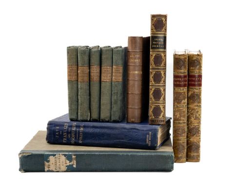
POLAR EXPLORATION: ASSORTED BOOKS comprising P.L.Simmonds, 'Sir John Franklin and the Arctic Regions: A Narrative Showing a Progress of British Enterprise for the Discovery of the Northwest Passage During the Nineteenth Century', second edition, London, George Routledge, 1851, frontis plate, two foldout maps, rebound, calf half bound, 16mo, together with Capt. John Franklin R.N., F.R.S., M.W.S., 'Narrative of a Journey to the Shores of the Polar Sea, in the years 1819-20-21-22', vols 1 and 2 (of 2), second edition, London, John Murray, 1824, calf half bound, ownership inscription to front end papers, 8vo, vol. 1 with ownership inscription to endpage; 'The Private Journal of Captain G.F. Lyon of H.M.S. Hecla, During The Recent Voyage of Discovery Under Captain Parry', London John Murray, 1824, frontis plate, fold out map, five plates, bookplate for 'John Drummond', full calf, gilt lettering to spine, 8vo, Captain McClintock, R.N., LL.D, 'The Voyage of the 'Fox in the Arctic Seas: A Narrative of the Discovery of the Fate of Sir John Franklin and his Companions', first edition, London, John Murray, 1859, frontis plate, two fold out maps, four plates, illustrations, clothbound, gilt ship to cover, gilt lettering to spine, 8vo; 'Appendix to Captain Parry's Journal', London, John Murray, 1825, quarter clothbound, 4to; Capt. W.E. Parry, R.N F.R.S., 'Journals of the First, Second, and Third Voyages for the Discovery of A Northwest Passage', vols 1-5, (of 5), London, John Murray, 1828, clothbound, 12mo (11)Provenance: private collection GlamorganComments: 'The Private Journal of Captain G.F. Lyon' spine minorly bumped, foxing to end papers, occasional foxing throughout, 'The Voyage of the 'Fox in the Arctic Seas' spine worn and beginning to fray, edges minorly bumped, cover minorly stained, 'Appendix to Captain Parry's Journal' spine worn, cover stained
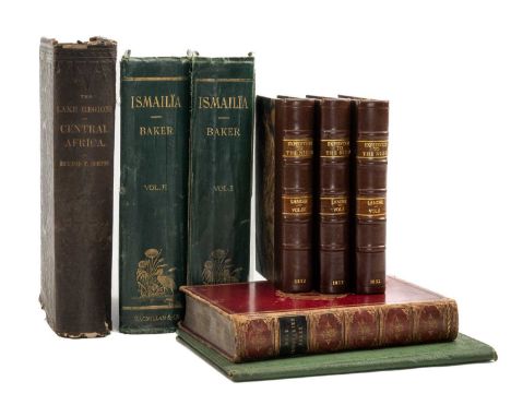
AFRICAN EXPLORATION: ASSORTED BOOKS, comprising Richard F. Burton, 'The Lake Regions of Central Africa: A Picture of Exploration', first American edition, New York, Harper & Brothers, 1860, frontispiece, 11 plates, illustrations, newspaper cutting related to Richard Burton inserted, leatherbound, gilt lettering to spine, 4to; Sir Samuel W. Baker, M.A, F.R.G.S, 'The Nile Tributaries of Abyssinia', London, Macmillan and Co., 1874, full calf, gilt lettering to spine, gilt Craigmount House School crest to font cover, marbled end papers, fold out map, all edges marbled, 8vo; Richard and John Lander, 'Journal of An Expedition to Explore the Course and Termination of The Niger with a Narrative of a Voyage Down That River to ots Termination, in Three Volumes', vols 1-3 (of 3), London, John Murray, 1832, frontis plate, all vols rebound, half Morocco, gilt lettering to spine, all edges marbled, 8vo; Captain Charles Chapman, 'The Suez Canal', second edition, London, George Berridge & Co. 1870, large fold out map, embossed gilt pictorial cover, 8vo, Sir Samuel W. Baker, Pacha, M.A., F.R.S., F.R.G.S., 'Ismailia: A Narrative of the Expedition to Central Africa For the Suppression of the Slave Trade', 2 vols (of 2), London, Macmillan and Co., 1874, clothbound, decorative gilt cover, gilt lettering to spine, 8vo (8)Provenance: private collection GlamorganComments: spine and corners bumped, minor tear to bottom of spine, spine and edges of 'The Nile Tributaries of Abyssinia' worn, cover worn with minor scratches, foxing to first and last few pages, occasional foxing throughout, 'The Suez Canal' back cover stained
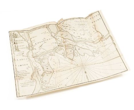
ENFIELD (WILLIAM) An Essay towards the History of Liverpool. FIRST EDITION, with large folding map, large folding diagram with tear and missing section lower left, folding chart of the Harbour with repairs, 7/9 plates, list of Subscribers, 116pp., small folio, nicely rebound in claret cloth and half leather with applied tile label to spine, Atherton of Walton Lancashire bookplate, Warrington, 1773Provenance: private collection West Wales

-
109182 item(s)/page