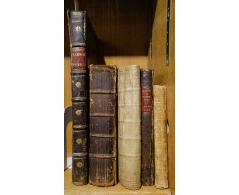
Manton (Thomas). A Practical Commentary, or an Exposition with notes on the Epistle of James. Delivered in sundry weekly lectures at Stoke-Newington in Middlesex, neer London, London: printed by J. Macock for Luke Fawne, 1651, title within typographic border and with early signature J. Hotchkis, some marginal browning, light dust-soiling and few marks, contemporary calf, old repairs to joints, upper board detached, rubbed and worn, 4to, together with: Jane (William), A Sermon preached on the day of the Publick Fast, April the 11th 1679 at St. Margarets Westminster; before the honourable House of Commons, London: printed by M.C. for Henry Brome & Richard Chiswel, 1679, imprimatur leaf present, bound with, Scott (John), A Sermon preached at the Assizes at Chelmsford, in the County of Essex, August 31, 1685, before the honourable Sir Thomas Street, Kt. one of the Judges of his Majesty's Court of Common Please, London: printed by M. Flesher for Rob. Horn & Walter Kettilby, 1686, and bound with five other similar pamphlets, each pamphlet badly damp-frayed & stained at fore-edge, contained within contemporary calf boards (volume raided with other pamphlets previously removed), old reback, 4to, Guarini (Battista), Il Pastor Fido, The faithfull Shepherd. A Pastorall written in Italian ... and now newly translated out of the original, London: printed by R. Raworth, 1647, one engraved plate only (lacking frontispiece), free endpapers torn away, contemporary mottled sheep, later maroon morocco title label to spine, upper joint cracked at head, extremities rubbed, 4to, and two others, Ambulator; or, the Stranger's companion in a tour round London..., 3rd edition, London: J. Bew, 1787, folding engraved map frontispiece, contemporary sheep, joints cracked, extremities rubbed, 12mo, and Barrow (Isaac), Opuscula; viz. Determinationes, conc. ad Clerum, Orationes, Poemata, & &c., volume 4 only (of 4), London: Brabazon Aylmer, 1687, engraved portrait frontispiece, title in red & black, contemporary calf, red morocco title label to spine, joints split, folioQty: (5)
![World. Moxon (Joseph), A Map of all the World and how after the Flood it was Divided among the Sons of Noah [1671 or later],](https://cdn.globalauctionplatform.com/bbef4553-41d6-4997-bfcd-adc700fe24a2/f3feaf22-1114-4966-8df2-adc900f69382/468x382.jpg)

![World. Ruscelli (Girolamo), Orbis Descriptio, Venice [1561], hand-coloured engraved map, very slight spotting, some finger so](https://cdn.globalauctionplatform.com/bbef4553-41d6-4997-bfcd-adc700fe24a2/473049c4-7de1-4725-9b34-adc900f69491/468x382.jpg)
![Bible [English]. [The Holy Bible, containing the Old Testament, and the New: newly translated out of the originall tongues...](https://cdn.globalauctionplatform.com/bbef4553-41d6-4997-bfcd-adc700fe24a2/ea7c7e99-f2e2-46db-beb1-adc900f6d435/468x382.jpg)

![[Dodsley, Robert]. London and its environs described ... in the City and in the country twenty miles round it, 6 volumes, Lon](https://cdn.globalauctionplatform.com/bbef4553-41d6-4997-bfcd-adc700fe24a2/3d7dbb73-7eaa-414b-a483-add401183613/468x382.jpg)


![Blaeu (Johannes). Comitatus Northantonensis vernacule Northamtonshire [and] Westmoria comitatus Anglice Westmorland, Amsterda](https://cdn.globalauctionplatform.com/bbef4553-41d6-4997-bfcd-adc700fe24a2/e2332c29-6919-4978-a299-adc900f65546/468x382.jpg)


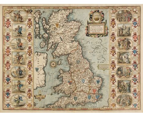
![British Isles. Speed (John), The Kingdome of Great Britaine and Ireland, 1st edition, John Sudbury & George Humble [1611]](https://cdn.globalauctionplatform.com/bbef4553-41d6-4997-bfcd-adc700fe24a2/3495da83-a3ce-4d4d-8a3d-adc900f65bcf/468x382.jpg)
![Buckinghamshire & Bedfordshire. Blaeu (Johannes), Bedfordiensis Comitatus Anglis Bedford Shire [and] Buckinghamiensis Com](https://cdn.globalauctionplatform.com/bbef4553-41d6-4997-bfcd-adc700fe24a2/0e0ffcd4-977f-482a-be80-adc900f65c8f/468x382.jpg)
![Buckinghamshire. Speed (John), Buckingham both Shyre and Shire Towne describ. George Humble, 1st edition, [1611], hand-colour](https://cdn.globalauctionplatform.com/bbef4553-41d6-4997-bfcd-adc700fe24a2/12bf527f-ea77-4f86-9d81-adc900f65d56/468x382.jpg)


![[MANUSCRIPT - CIPHERING]. EVANS, Cadwallader. Ciphering Book of a Colonial Schoolboy. [Philadelphia], 6 April-26 July 1763. &](https://cdn.globalauctionplatform.com/972f54cb-c6fc-4bf1-9d72-adc10131c7e7/5998b82a-47f8-40a9-9e2b-adc201259bda/468x382.jpg)
![HERRERA Y TORDESILLAS, Antonio de. Descripcion de las Yndias del Norte 2. [Madrid, 1622]. Copper engraved map of Americ](https://cdn.globalauctionplatform.com/972f54cb-c6fc-4bf1-9d72-adc10131c7e7/fc8a88cf-ac46-4ee8-9de7-adc20142ecca/468x382.jpg)
![[TEXAS]. Map of Bexar County, Texas. San Antonio and Austin: Samuel Maverick & John H. Traynham, 1889. Engraved map](https://cdn.globalauctionplatform.com/972f54cb-c6fc-4bf1-9d72-adc10131c7e7/533ae40b-5aba-4c19-889b-adc20146a158/468x382.jpg)

![[TRAVEL & EXPLORATION] -- [AFRICA] -- Proceedings of the Association for Promoting the Discover of the Interior Parts of](https://cdn.globalauctionplatform.com/972f54cb-c6fc-4bf1-9d72-adc10131c7e7/5106d6aa-b689-4427-8aa1-adc20163cb31/468x382.jpg)