We found 109198 price guide item(s) matching your search

Refine your search

Year

Filter by Price Range
  • List
  • Grid
  • 109198 item(s)
    /page

Lot 1021

A Morden Map of Warwickshire

Lot 1180

A hand coloured John Speed map of Caernarvon, framed

Lot 1181

A hand coloured John Speed map of Anglesey, framed

Lot 1210

A small antique framed map of 'Cathanes and Orknay', Peter Van Den Keere speed map

Lot 57

A framed Ordnance Survey map showing part of Kent dated 1907

Lot 105

A hand-coloured map of Sussex and another of the Cranbrook area together with a hand coloured map of Essex and Sussex

Lot 106

Dorothy Tustain, hand-painted map of East Sussex and Kent dated 1955

Lot 733

An 18th century sampler - Wrights map of Cornwall - worked in colours by Ann Collins in the 12 year of her age at Warrens School, Truro - bearing armorial and motto - one and all - 36 cm x x 49.5 cm

Lot 848

A Road map - Exeter to Truro - with table verso plates 179 & 180

Lot 1408A

A late 19th century ruby and gilt decanter and stopper, 31cm high, a blue and white pot pourri, a reproduction map, a plaster bust of Beethoven, Georgian style mirror and a book - English Period Furniture

Lot 86

Lock (Wm. Geo.), Guide to Iceland; A Useful Handbook for Travellers and Sportsmen, nd., folding map, original cloth; with a small collection of other guide books

Lot 17

Three boxes of sundry items to include various ephemera, postcards, etc, mono type font sample cards, assorted china and glassware, wicker basket, map carrier, etc

Lot 414

AFTER THOMAS KITCHIN "A New Map of England and Wales...", coloured engraving, AFTER E JONES "Turkey in Europe", coloured engraving, published C Smith 1808 and two engraved maps of The Western Hemisphere and Eastern Hemisphere from Stieler's Hand Atlas

Lot 415

AFTER F DE WITT AND P MORTIER "Wales and Gloucestershire", coloured engraving, together with PIGOTT & CO's "Map of England and Wales.....", published 1825 and "The Metropolitan Boroughs as defined by the Reform Bill", black and white engraving

Lot 447

AFTER ANNIE TEMPEST "Enjoying one's husband's hobbies", limited edition colour print No'd 208/850, another "What do you make of that new chap at the Old Rectory, Dicky? ...", limited edition colour print No'd 100/1000 signed in pencil, BINGHAM MCGUINNESS "River landscape with figures in boat in foreground and church spire rising in background", watercolour heightened with white, signed and dated 1880 bottom left, AFTER P DUVAL "Costes de Guinée", coloured map, ENGLISH SCHOOL "Study of daffodils in a jug", oil on board, unsigned, and K. WATKINS "Stately Home with figures and golf trolleys in foreground", watercolour heightened with white, signed and dated 1980 bottom left
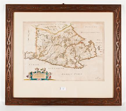
Lot 183

Bacon's 'New Map of the Isle of Wight' with town plans for Ryde, Ventnor & Newport - folding map on silk - 45x65cm, with folder

Lot 200

John Speed - Wight Island - 40x51.5cm coloured map of the Isle of Wight with town plans for Newport and Southampton, sold by John Sudbury & G Humbell

Lot 213

A late 18th century embroidered map - 'An Accurate Map of England & Wales, Scotland, France & Ireland 1779', showing counties and shires - 65x53cm

Lot 231

An early 20th century motor tourist's leather case containing thirty-seven Edward Stanford maps, Index, original measuring wheel, maps laid on linen, case 20x40x10cm, together with a Bacon's cycling & motoring road map

Lot 311

Engravings - Nottinghamshire, strip map etc (9)

Lot 314

Hunting map of the Quorn and surrounding counties

Lot 318

Coloured strip map - The Extended Road from Oakham to Richmond in Yorkshire, John Ogilby

Lot 321

A map of Melton Mowbray, T G Grey 10/100

Lot 214

Falkland Island Dependencies. A mint collection on loose album pages, includes map varieties. Also a neatly written up , small collection of Air Mail covers between the Falkland Islands and Argentina 1971 to 1972

Lot 215

Falkland Island Dependencies. 1948 Thin map issue. Mint plate blocks of four with additional two plate blocks of the 2 1/2d

Lot 580A

A small Georgian mahogany map chest with 5 graduating long drawers and 2 short drawers, with brass ring handles and bracket feet, width 41

Lot 1

"CHRISTOPHER SAXTON (c.1540 - c.1610) Engraved Map of Devonshire hand-coloured (faded), with considerable time staining , scuffing and rubbing of paper surface in many areas, and other surface defects on paper laid down on backing card, unframed,16 x 18in (40.6 x 45.7cm), sold a/f; John Speede ‘The Kingdom of Persia with cheef Cities and Habites’, sold by Richard Chiswell; and Thomas Basket, engraved map, unframed with paper loss, particularly top left corner; and a folio containing four unframed county maps by Robert Morden - Leicestershire, Bedfordshire, Barkshire (sic), and Lincolnshire, the latter two coloured; six (6)"

Lot 23

"SAMUEL BUCK (1696-1779) AND NATHANIEL BUCK (fl. 1724-1759) The North East Prospect of Richmond in the County of York, engraved Map originally published 1749, 12 1/2 x 31in (31.7 x 78.7cm), a further map titled The south West Prospect at Birmingham in the County of Warwick; a miscellaneous selection of broadsheets including one for ‘The Trial and Execution of William Kennedy’; an oval silkwork picture depicting ‘Pope’s House’; a profile wax portrait of a Gentleman; and an 18th Century miniature of Robert White, Rector of Burgh, nr Yarmouth (qty)"

Lot 289

JOHN SPEEDE, a 17th century hand coloured Map of "The North and East Riding of Yorkshire" in a double sided frame with script to the reverse, 15" (38cms) x 20" (51cms).

Lot 112

An old print map of Berkshire, printed by Carrington and Bowles, St. Pauls Church Yard, London, 58cm x 70cm

Lot 826

Cary`s Traveller`s Companion, Or A Delineation of the Turnpike Roads Of England and Wales, shewing the immediate Route to every Market and Borough Town throughout the Kingdom, laid down from the best authorities on a New Set of County Maps, London 1810, printed for John Cary, Engraver and Map Seller, Strand, leather bound, 18.5cm high

Lot 992

Collins Railway Map of England & Wales, and Part of Scotland, Shewing the Inland Navigation By Means of Rivers And Canals together with the Rail and principal Turnpike Roads From The Most Recent Surveys, London: Published By H.G. Collins, Paternoster Row, folding and mounted on cloth, 67cm wide x 96cm high

Lot 994

Reynolds Map of London and Visitors Guide, divided into quarter mile sections, folding and on cloth, 73.5cm wide x 50cm high

Lot 995

Ric Blome, a coloured Map of the County of Suffolk 1673, Thomas Timperley of Hintlesham Hall Esq., this map is humbly dedicated by Ric Blome, the map 35cm wide x 29.5cm high

Lot 996

Robert Morden, coloured map of Nottingham Shire, and part of Darby Shire, 43cm wide x 36cm high, together with, Robert Morden, coloured map of Lincoln Shire, 43cm wide x 38.5cm high, and John Speede, The Countie of Nottingham, 52cm wide x 39.5cm high, (3)

Lot 997

Stanford`s Map of Scotland, folding and in two parts, London: Published by Edward Stanford, 55 Charing Cross, S.W. August 1st 1882, on cloth, 105cm wide x 121.5cm high, with case

Lot 329

MATTHAUS MERION OF FRANKFURT TURCICUM IMPERIUM, MAP OF THE OTTOMAN EMPIRE DATED 1635 two joined engraved folio pages with hand colouring 28cm x 36cm overall Label Verso: Koheji`s Arabesque Gallery. Manama, Bahrain map has elaborate painted legend of The Sultan and two attendant warriors

Lot 373

TIMOTHY PONT: 17TH CENTURY MAP OF CAITHNESS titled `Caithnesia`, hand coloured, in a knotwork mahogany frame, 54cm high, 64cm wide Some mild discolouration.

Lot 170

LONDON. Round About Piccadilly Pall Mall (London: 1870). Fine edition- inscribed to Mrs George, with the author`s compliments. 8vo. WALFORD, EDWARD. Old And New London. A Narrative of Its History, It`s People, and It`s Places. 6 vols. 4to. WALFORD, EDWARD. Greater London (c.1880) lacks map. 2 vols. 4to. Selling with MACQUEEN-POPE, W. Goodbye Piccadilly (1960: London) 8vo and HOLMES, E. London`s Country Side (ND: London). 8vo. (11)

Lot 196

Bonetti, Italian School, 20th Century landscape study with horse and carriage in the hills above Naples with Vesuvius to the background (28 x 21cm) and Bettini, Italian School, late 19th Century, landscape of house by water`s edge with sailboats, one bearing Venetian Cross, watercolour, signed lower right (18.5 x 44.5cm) and a map of Central Italy, 19th Century (19 x 26cm). (3)

Lot 276

A pair of framed etchings of a church, indistinctly signed and dated `53, a coloured map of Norfolk, framed, and an oil on board of a flower, signed and framed. (4)

Lot 277

A framed map of Europe, printed in the reign of Carolina, Queen of Great Britain, France and Ireland, printed for I. Bowles, map seller, Black Thorne House, Cornhill (62 x 98cm).

Lot 8

LEYCESTER, SIR PETER. Historical Antiquities, in two Books. The First Treating in General of Great Brettain and Ireland. The second containing particular remarks concerning Cheshire. --------. MDCLXXIII [1673]. Map. Folio. Cont. Cf. Re-backed. ESTC R 2116

Lot 11

LEIGH, CHARLES. The Natural History of Lancashire, Cheshire, and The Peak, in Derbyshire -------. Oxford. MDCC [1700]. Folio. Map and plates. Cont. Cf. Rubbed. Re-backed

Lot 13

HENSHALL, J.H. The History of The County Palatine of Chester. Chester. 1817. 4to. Map and plates. Cont. Hf. Cf. Worn WITH 4 others re; Cheshire (5)

Lot 15

LYSONS, DANIEL AND LYSONS, DANIEL. Magna Brittania ------. Vol II Part II containing the County Palatine of Chester. 1810. 4to. Map and plates recent 1/2 cf. WITH another

Lot 19

DEAN AND CO., 1804. Map loosely tipped in (1)

Lot 36

PIGOT. 1838. Map. T.P. and first leaf laid down (1)

Lot 37

PIGOT AND DEAN`S NEW DIRECTORY OF MANCHESTER AND SALFORD. 1821-2. Lacks map 1/2 skiver (1)

Lot 41

SLATER ------- DIRECTORY OF MANCHESTER AND SALFORD. Lacks map. Sm. 4to

Lot 42

KELLY. P.O. DIRECTORY OF CHESHIRE. 1857. Lacks map. Sm. 4to.

Lot 43

KELLY. CHESHIRE. 1902. Map WITH KELLY. CHESHIRE. 1914. Map (2)

Lot 44

KELLY. CHESHIRE. 1934. Map. Backstrip loose. WITH KELLY. CHESHIRE. 1939. Map (2)

Lot 45

BAGSHAW, SAMUEL. HISTORY, GAZETTEER AND DIRECTORY OF DERBYSHIRE -----. Sheffield; 1846. Lacks map. WITH SLATER CHESHIRE, DERBYSHIRE [1876] (2)

Lot 46

WHITE. HISTORY, GAZETTEER AND DIRECTORY OF CHESHIRE. Sheffield: 1860. Lacks map WITH SLATER`S CHESHIRE. 1869 (2)

Lot 48

PIGOT AND DEAN. MANCHESTER AND SALFORD. 1825-5. Map (1)

Loading...Loading...
  • 109198 item(s)
    /page

Recently Viewed Lots