We found 108737 price guide item(s) matching your search

Refine your search

Year

Filter by Price Range
  • List
  • Grid
  • 108737 item(s)
    /page

Lot 198

ANTIQUARIAN MAPS - Robert Morden, hand coloured engraved map circa 1720 - the smaller islands in the British Ocean, 39.5 x 46.5cms and John Senex, two hand coloured engraved maps circa 1719 - 'The roads from Shrewsbury to Holywell' and 'The road from Chester to Cardiff', 16 x 21.5cms

Lot 353

VINTAGE WINSOR & NEWTON WATERCOLOUR PAINT SET - in black japanned tin, one other similar, 20 vintage canvas backed folding maps, Welsh Counties, antique hand coloured engraved map 'The Road from Kendall to Cockermouth', 19.5 x 12cms, ETC

Lot 18

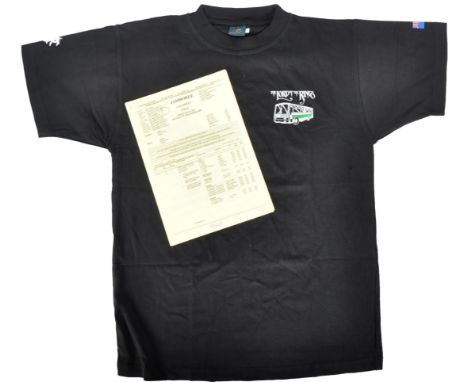
The Collection Of Bernard Hill - The Lord Of The Rings (2001-2003) - a collection of memorabilia from production, to include; one of Hill's call sheets dated 4th December 2000 carrying the secret title ' Jamboree '. The call sheet being a two-page document detailing various information for the production on that day. Along with a separate A4 page with map and directions to Edoras - signed by Hill in black ink. The documents accompanied by an original crew-only LOTR transport service t-shirt (black, size S, by Cotton Force).  

Lot 116

J A Knipe Geological and Mineralogical Map of England and Wales, with parts of Scotland, Ireland, 1871.Cornwall Library 1883Hand coloured, folding into book.

Lot 124

LARGE MAP OF CAMBRIDGE CIRCA 1575, by Braun and Hogenberg64cm x 54cm     

Lot 216

A large coloured print depicting an interior scene; a coloured print of sailing ship "Flying Cloud"; another marine print after Turner; a framed map; a framed post-card and various other pictures and prints

Lot 282

A coloured map of Berkshire

Lot 76

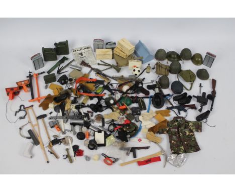
Palitoy - Hasbro - Dragon - Other - A collection of Action Man and other action figure, accessories, and spare parts from various manufactures. Lot includes Action Man crutch and stethoscope; Palitoy MP52A gun; tool box; GI Joe camouflage jacket; pick axe; map canister; detonator; various hats and similar. Items range in condition from Fair - Very Good and are all unchecked for completeness. (This does not constitute a guarantee)
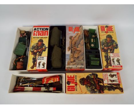
Lot 88

GI Joe - Action Man - Palitoy - Hasbro - Others - Four GI Joe / Action Man modern boxes each containing a quantity of loose mainly Action Man and GI Joe weapons and accessories. Equipment included in the boxes includes Action Man Engineers Surveyor theodolite with tripod; 81mm Mortar; M16; Browning machine gun; radios, map canister; flag; jungle knife and similar. Boxes have some storage related wear appearing Good overall and DO NOT CONTAIN FIGURES. Items within boxes show play and age ear, generally ranging Fair Plus - Very Good and are unchecked for completeness. Kit bags are filled with packaging only and do not contain accessories (4) (This does not constitute a guarantee)Condition Report - The MP radio featured in this lot does NOT posses any makers marks. It is blank to the rear - please refer to photograph showing comparison with normal field radio.
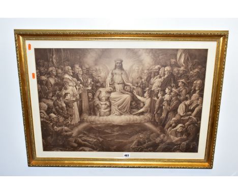
Lot 35

Large vintage London midland region system map

Lot 481

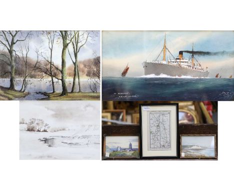
PICTURES AND PRINTS ETC, COMPRISING TWO FRAMED JAPANESE HAND PAINTED TILE PICTURES, two Emilie Vouga prints depicting Stags, a Thomas William Camm religious print 'Christ the Consolator', laminated Bartholomew's map of the British Isles 1-1000000 scale, two Toyota F1 poster prints, and reproduction cinema posters 'Casablanca' and 'Wizard of Oz'

Lot 547

A 20TH CENTURY FLORAL STILL LIFE FLOWER STUDY, MONOGRAMED JA BOTTOM LEFT, Unicorn Gallery label and artist biography for Elia Jozsa verso, oil on board, approximate size 40cm x 29cm excluding frame, chips to corner edges of the frame, together with a print 'Girl with a pearl earring' after Vermeer, approximate size 82cm x 72cm including frame, Turner print 'Bridge of Sighs', reproduction map of Staffordshire, a modern needlework panel depicting fruit, a wood framed mirror and a copper umbrella stand branded X-ist to the base

Lot 1454

° ° Cary’s New Map of England and Wales with part of Scotland, a leather bound volume, published 1794,

Lot 172

Five 1930'/40's posters and Maryport Harbour and Docks map. Posters including"Notice this bridge is closed to all traffic", "Maryport Harbour only one vechicle may cross this bridge at one time"

Lot 1304

A box of assorted ordnance survey maps. Titles include Carlisle & Solway Firth, Appleby, Wenslydale, Barnard Castle and Richmond, Northern Scotland, Munro Map and many others.

Lot 431

Map of Cape District, Cape of Good Hope, 53cm x 34cm, framed & glazed

Lot 764

A nautical chart, River Thames Entrance North Foreland to the Nore, corrections to 1904, one other map, South East Coast The Downs, similar age and a collection of 1860's newspapers, The Evening Star, Standard and Mercury

Lot 352

A small map and various engravings.

Lot 2038

A small quantity of books to include three copies of Familiar Wild flowers by F.E. Hulme, Complete Works of William Shakespeare, The Britannia or an Illustration of The Kingdom of England, The Water-Babies, a Map of The Country of Devon 1765 by Benjamin Donn.

Lot 1083

A quantity of old sheet music including, International Song Book, Favourite Carols, Bach, etc, together with a framed old Monmouthshire map.

Lot 1122

A framed and glazed Map of Staffordshire by Rob(ert) Morden (a/f), 11 1/2" x 14".

Lot 184

' Wonderful Britain ' early-to-mid 20th century sectional road map, 32 cards, contained within a canvas folder, 28.5cm long together with The Motor Map of England, Wales & Southern Scotland, 6 sections

Lot 283

Antique Hand Coloured Map of Bremen and Hamburg, 35.5cm x 27cm together with Reproduction Saxton's Map of Dorsetshire, Reproduction Joannes Blaeu Map of Essex and Reproduction Antique Map of Monmouthshire

Lot 318

Large Collection of Unframed Oils, Watercolours, Pencil Drawings, Prints, Map, etc

Lot 353

Robert Morden (British c.1650-1703): 'The East Riding of Yorkshire', engraved map with hand colouring 36cm x 42cm, a Judges' tinted photo. of Robin Hoods Bay, and a monochrome photo. of Hutton-Le-Hole (3)

Lot 1431

The Cyclist Pocket Touring Maps of Britain, Philip's tape indicator map of London, stamps:- One Tray.

Lot 1534

A Pair of Embossed Pictures of Dead Game and Birds, on simulated wood grounds, circa 1900, in pweriod frames, 45.5 x 38cm overall; a map of Cumberland, hand coloured, circa XIX Century, Yorkshire East and West Riding, and Lancashire maps. (5)

Lot 632

Framed Bleu's Atlas of Scotland surveyed by Timothy Pont and Robert Gordon. This map is from 1663 with french text depicting Fife. [62x73cm]Along with a engraving of Dunbar Close [35x28cm]

Lot 703

A Lot of three Scottish Clan Stewart books: The Historical Geography of the Clans of Scotland by T.B. Johnstone, and Colonel James A. Robertson, Second edition. 1873- [fitted with map]. The Stewarts of Appin by John H. J. Stewart and Lieut,-Col. Duncan Stewart, Late 92d Highlanders, 1880- comes with various letters from the Stewarts society. The Story of the Stewarts- Printed for the Stewart Society 1901.

Lot 1051

British School (20th Century)''SS Nerehana, English Channel'' Indisticlty initialled, inscribed and dated 1915, watercolour and gouache, together with four landscape watercolours by P*Woolridge, Peter Shutt, two by W Miller Knight and an 18th century Yorkshire road map (6)

Lot 1066

A map of North Riding of York, C & J Greenwood, 1834, and another, both framed

Lot 1078

Robert Morden (c.1650-1703) "The County of Monmouth", together with a further map of Monmouth by Morden and a reproduction map of Monmouthshire by Richard Blome (3)

Lot 1199

A George II Walnut Fretwork Mirror, 61cm by 35cm, together with a 19th century picture clock depicting Elizabeth Tower, a framed fabric map of Europe and a wicker and bamboo cradle (4)

Lot 245

Assorted Mainly Early 20th Century Costume Accessories, comprising pair of cream silk sleeves, another pair in cotton with embroiderySavecotton collar and shoulder capesthree embroidered silk sashes woven with floral designs in purple, red and pale blueWWII items including a pair of gents cream evening gloves, Towles Ltd single stocking dated 1952, silk map of North Africa, Souvenir of France silk handkerchiefmodesty panels, mittens, stockings etc(one box)

Lot 393

Three framed maps, hand-coloured map - 'Britannia Romana', 36cm x 42.5cm, Somersetshire and Cornwall, all framed and glazed

Lot 81

An Architect's cased street plan model, with streets, houses, office buildings, ecclesiastical buildings, etc, 76 x 75 x 15cm and a map of Toxteth and Blundellsands (2).Qty: 2Please note that this lot is not suitable for our in-house postage service.We would recommend booking a collection slot for this lot or contacting Mailboxes Etc for postage of this lot, their details can be found on www.adampartridge.co.uk/services/postage-shipping/

Lot 319

A silk-style military WWII escape and evasion map of North Africa containing Morocco, Algeria, Tunisia, Italian Libya and Spanish Rio De Oro and a WWII commemorative velvet embroidery with images of pharaoh, Pyramids and palm trees in the desert, embroidered 'Egypt 1943' (2).Qty: 2

Lot 324

A quantity of interwar maps, diaries and other ephemera relating to military issue, to include a Flight Diary for Singapore K383 dated October 1936, also a War Office map, newspaper cuttings, photocopies, miscellaneous press-style photographs including military related examples, to include 'The RAF Mountaineering Association Himalayan Expedition to Climb Masherbrum (K1)', depicting the team and their incredible paper tent, dated 1981, together with a folder containing the Royal Air Force Museum Hendon Visual Tour Transcript and a quantity of coloured photographs of exhibits, etc.
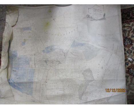
Lot 1539

An antique map of Cheltenham & Cirencester by Walker after Creighton, 25 x 19cm

Lot 1651

A 17th Century colour map of Hampshire by Thomas Bassett

Lot 1065

DOUGLAS, R. China 1st.ed. 1882, London, 8vo orig. gt. dec. cl. fldng. map plus 5 other travel books (6)

Lot 134

A collection of framed prints, photographs, needlework picture, map and similar, varying image sizes.

Lot 347

Mixed pictures to include five engravings by E. Sharland, 19th century map of England and othersLocation:

Lot 105

A metal tube containing various late 18th/19th century legal documents relating to property in the and around the town of Setterington in the county of York, along with an 18th century map of the township of Setterington by S Dickinson and R Stickney Surveyors, circa 1797

Lot 161

Saxton - Kipp, hand coloured engraved map - Dunelmensis, map of Durham, glazed frame

Lot 196

Robert Morden - 18th century map of Essex in glazed frame, together with a Morden map of Suffolk and two facsimile maps. (4)Essex map in good condition, in a later frame. The Suffolk map is unframed and is creased with a small tear. The other maps are later copies.

Lot 429

Pencil study of a court room at the Old Bailey, 19th century engraving of a cartoon, map and other pictures and engravings.

Lot 290

West German M62 Steel Helmet complete with liner size 53-55 and webbing chinstrap: small map case maker marked "Edward Standford Ltd, London: WW2 British Booklet "Ranks and Badges" published 1940: Booklet "Ships in Bottles". (4)

Lot 457

Cartography - Richard Palmer, Relievo Map of Palestine or the Holy Land, Illustrating the Sacred Scriptures and the Researches of Modern Travelers, published by Dobbs, Baily & Co., London, [1845], 55.5cm x 45cm, maple frame

Lot 484

Cartography - a 19th century lacquered brass tripod map reading lens, 4.5cm diam

Lot 710

Robert Morden (c. 1650 - 1703), by, two-page map, Darbyshire (sic, Derbyshire), [Published and] Sold by Abel Swale, Awnfham (sic) and John Churchill, London, [n.d., early-mid 18th century], hand-coloured copperplate engraving, 34cm x 40cm

Lot 2434

A MODERN COFFEE TABLE, 30X23" WITH BRASS FRAME ENCLOSING 1961 SAXTON'S MAP OF LANCASHIRE

Lot 203

A SELECTION OF BOOKS AND MANUALS RELATING TO THE ROLL OF THE HOME GUARD DURING WW2, the books include the story of A Sector home guard on Warwickshire, a war time map showing the positions of the Home Guard Headquarters, pill boxes, road blocks etc in Stafford, Rugeley and Cannock,2 home guard shoulder titles, leaflets relating to 39th Cheshire home guard plus other manuals relating to the RAMC, home guard rules and regulations etc.

Lot 224

A GROUP OF WORLD WAR ONE MEDALS TOGETHER WITH POSTCARDS & MAP, together with a Boer War Medal, as follows, British War & Victory Medal, named to 58377 Pte F.B. Cumberlidge, Royal Warwick Regiment, together with a Queens South Africa Medal bars, Cape Colony, Orange Free State, Transvaal named to Gunner J Victor O Battery RHA & a number of postcard photos of WW1 sites etc collected by Cumberlidge, a Northern France War office map dated 1914, South Staffs Regiment Cap badge, & a 1939 dated Gas mask. plus a Bronze Royal lifesaving award medallion dated 1944 B Cumberlidge

Lot 200

AN ALBUM OF WWII COMMEMORATIVE COIN AND STAMP COVERS, to include a limited £2 D-Day Anniversary coin cover in its folder, liberation of Jersey £2, Dunkirk evacuation £5, a collection of Battle of Britain first day covers and £5, 50p, one crown coins, return of the Vulcan coin cover, a limited RAF centenery limited to 1000 coin cover, a loose £5 80th annaiversy in plastic casing and royal airforce 50p, etc, all look to be in great condition, together with a souvenir paper copy of Berghofbunker map and other military related ephemera

Lot 165

John Blaeu original sparsely coloured map of Pembrokeshire and Carmarthenshire. 44x53cm approx. Framed and glazed. (B.P. 21% + VAT)Border and some margin with plate mark visible but not removed from frame.  Later coloured.  Appears good overall condition.  Modern, unsuitable frame. 

Lot 163

Reproduction John Speede map of Pembrokeshire. Unframed. (B.P. 21% + VAT)

Lot 161

John Blaeu original sparsely coloured map of Pembrokeshire and Carmarthenshire. 41x53cm approx. Framed and glazed.(B.P. 21% + VAT)Some margin shows outside mount but plate mark not visible all the way round.  Some discolouring, later coloured.  Back enclosed. Modern, unsuitable frame.

Lot 162

Joan Jansson, original sparsely coloured map of South Wales. 41x53cm approx. Framed and glazed. (B.P. 21% + VAT)

Loading...Loading...
  • 108737 item(s)
    /page

Recently Viewed Lots