We found 109182 price guide item(s) matching your search
There are 109182 lots that match your search criteria. Subscribe now to get instant access to the full price guide service.
Click here to subscribe- List
- Grid
-
109182 item(s)/page


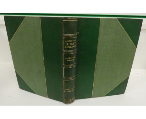


Lot 49
SHAW J. (Pubs). The Tourist's Guide to the Lakes. Fldg. eng. map. 24mo. Green calf. Penrith, 1826; also Journal of a Tour ... in Various Parts of Cumberland & Westmorland ... & A Visit to Edinburgh ... By A Lady, orig. cloth, 32mo, York, 1840 & J. Walker, The History of Penrith, rebound half red morocco, Penrith, 1858. (3).


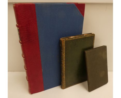
Lot 55
HUDSON J. (Pubs). A Complete Guide to the Lakes ... with Mr. Wordsworth's Description of the Scenery. Eng. frontis & plates. Orig. green cloth, splitting internally at hinge. Kendal, 1846; also Jonathan Otley, A Descriptive Guide to the English Lakes, hand col. fldg. eng. map, plates & illus., orig. cloth, Keswick, 1843 & 5 others, Lake District guides & similar. (7).

Lot 58
MANNEX P. J. History, Topography & Directory of Westmorland & Lonsdale North of the Sands. No map. Half calf, much mkg. to early leaves. 1849; also Jollie's Cumberland Guide & Directory, fldg. & other eng. plans & plates (tape reps.), at least one plate lacking, rubbed half calf, internal browning, Carlisle, 1811 & Edward Bellasis, Westmorland Church Notes, 2 vols. in one, frontis, half calf, Kendal, 1888 & 1889. (3).


Lot 148
MACKENZIE E. Historical, Topographical & Descriptive View of the County of Northumberland. 2 vols. Fldg. eng. map & eng. plates. Quarto. Half maroon morocco. Bookplate of Ravensworth Castle. Newcastle, 1825; also Mackenzie's Descriptive & Historical Account of Newcastle-Upon-Tyne, 2 vols. in one, eng. plates, quarto, old reverse calf, Newcastle, 1827. (3).

Lot 172
BAINES EDWARD. The History of the County Palatine & Duchy of Lancaster, ed. by John Harland. 2 vols. Fldg. map & text illus. Quarto. Orig. green cloth gilt, tending to split at hinges. 1868 & 1870; also Matthew Gregson, Portfolio of Fragments Relative to ... Duchy of Lancaster, ed. by John Harland, illus., folio, worn cond., 1869 & J. P. Earwaker, History of the Ancient Parish of Sanbach, ltd. ed. 250, illus., quarto, orig. green cloth, 1890 & 1 other vol. (5).


Lot 178
HUTCHINSON W. An Excursion to the Lakes in Westmoreland & Cumberland with a Tour Through Part of the Northern Counties. Fldg. & other eng. plates. Rebound half calf. 1776; also Joseph Mawman, An Excursion to the Highlands of Scotland & the English Lakes, fldg. eng. map, 3 eng. plates after Turner, rebound half calf, 1805. (2).


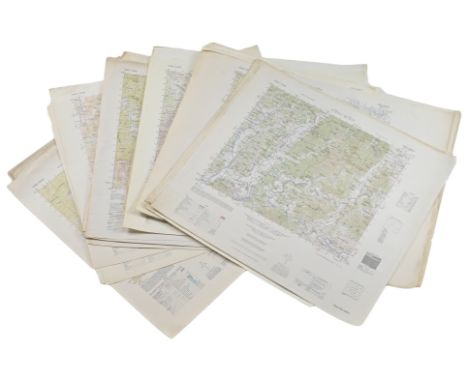
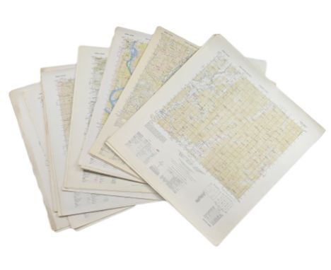
Lot 224
US DEPARTMENT OF DEFENSE. KOREAN WAR MAPS (1950-1953) YONCH'ON, CH'ORWON AND OTHERS. Washington DC: US Army Map Service. Seven maps from the country, of Yonch'on (7), Ch'orwon (7), Tuksom (9), Uijongbu (8), Sanyang-Ni (3), Hwach'on (4) and Tunjon-Ni (8). Yonch'on and Ch'orwon were on the front line and saw heavy fighting in 1952. Each map measures up to 56cm x 62cm, with map image of 37cm x 43.5cm. All are paper, and unfolded. (46) Condition is overall very good, with a few maps showing minor discolouration or creasing. Good/very good.
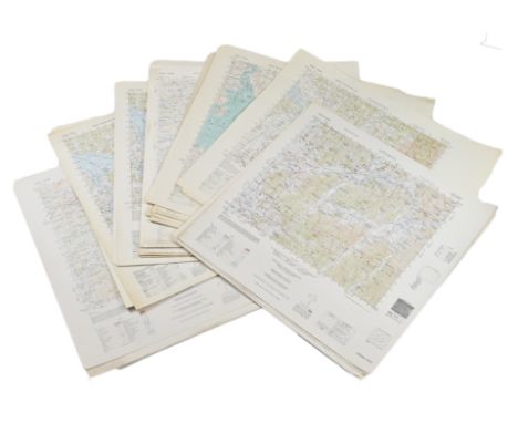
Lot 225
US DEPARTMENT OF DEFENSE. KOREAN WAR MAPS (1950-1953) INCLUDING SANGYONG, MAJON-NI, AND YANGHOP-TONG. Washington DC: US Army Map Service. Seven maps from the country, of Sangyong (17), Majon-Ni (8), Yanghop-Tong (8), Sibyon-Ni (7), Kap'Yong (10), Poch'On (9), and Chip'o-Ri (7). Each map measures up to 56cm x 62cm, with a map image of 37cm x 43.5cm. All are paper, and unfolded. (66) Condition is overall very good, with some showing minor discolouration and/or creasing. Good/very good.
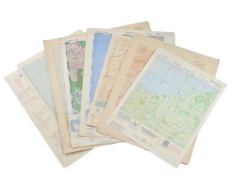
Lot 226
US DEPARTMENT OF DEFENSE ARMY MAP SERVICE. KOREAN WAR MAPS (1950-1953) INCLUDING KAESONG, TONGJIN AND KOYANG. Washington D. C.: Army Map Service. Seven maps from the country, of Kaesong (8), Tongjin (8), Koyang (8), Munsan (7), Kump'o (8), Kyongsong (7), and Kumhwa (7). Each map measures up to 56cm x 62cm, with a map image of 37cm x 43.5cm. All are paper and unfolded. (53) Condition is overall very good, with a few maps showing minor discolouration and/or creasing. Good/very good.

Lot 227
US DEPARTMENT OF DEFENSE. WORLD WAR 2, SUMATRA, INDONESIA AND DUTCH EAST INDIES MAPS (1943-1946). US Army Map Service. Eight maps, from Dutch East Indies: Dutch Timor, Isle of Roti; Portuguese Timor; Dutch Timor, different location; Tobaki; Atamboea; Noil Besiam, Noeaf Moetis and Res. Timor en Onderh. All linen backed. Each map measures around 54cm x 48cm with the map measuing 36.5cm x 42cm. All flat and unfolded. (8) Condition overall very good, with one or two showing minor discolouration or creasing. A discreet university stamp to edges. Good/very good.
Lot 228
US DEPARTMENT OF DEFENSE. WORLD WAR 2, SUMATRA, INDONESIA AND DUTCH EAST INDIES MAPS (1944-1946). US Army Map Service. Eight maps from Dutch Sumatra and Timor: Gle Jeueng (paper) and Lho'Nga (paper) each 61.5cm x 48.5cm; Soe; Res. Timor en Onder,; Noenkolo; Solioe; Portuguese Timor, and Dutch Timor, sheet 90/XLVI. Linen-backed and measure around 36.5cm x 42cm, bar the two paper copies, and are flat and unfolded. (8) Condition overall very good, with one or two showing minor discolouration or creasing. A discreet university stamp to edges. Good/very good.

Lot 353
Two Japanese woodblock prints by Utagawa Hiroshige (1797-1858)Hakone, from the 53 Stations series; and The Kinkakuji (Golden Pavillion), from the series of Famous Palaces of Kyoto17 x 23cmtogether with an engraved map of China, 1800, by J. Wilkes; and other items including 2 signed Cecil Aldin prints

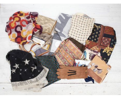
Lot 1461
A collection of women’s gloves in a variety of styles, including elbow length black velvet, mid-forearm length matte black and two leather gloves in dark and light brown. A collection of scarves in a variety of styles and patterns. Lot includes two 100% silk scarves by John Galliano, with the brand name bordering the fabric of the scarf. One is in turquoise blue and the other in dark grey. Also includes an 100% silk John Galliano scarf in black with a newsprint pattern bordering the edge. The John Galliano logo and a smattering of large cream stars covers the main body of the scarf. A Moschino 100% silk scarf in dove grey. The Pop Eye character ‘Olive Oyl’ is printed on it, as is the Moschino logo in spray painted font. A cream-coloured chiffon scarf bordered in red with a pattern of a map decorating the body. An 100% silk AssiDomän scarf in navy blue with a geometric pattern in yellow, red, and green. A chiffon Coach scarf in a colour way of aubergine, yellow, claret, white, and tomato red in a geometric circle pattern. A square coral coloured scarf patterned with poodles and street lamps. A square cream scarf bordered with a navy strip. It is patterned with a vintage style beach scene of deckchairs and beach parasols in a colour way of red, turquoise, navy and cream. A large black square scarf patterned in an opulent fleur de li design in gold, turquoise and red. A square scarf in a colour way of baby pink, aubergine, turquoise and cream. It has the logo Plaza Toros in the centre. The scarf is patterned in a collage pop art style with Ben-day dots, Spanish figures, and floral designs. A square paisley patterned scarf in cream and coral. A wide scarf in a colour way of coral, tangerine, brown and mustard and decorated in rows of abstract tribal designs. The fabric has a soft, corrugated texture and the edges are fringed. A large scarf with a Picasso style painting of a woman printed on it in taupe, coffee and white. A scarf in dove and slate grey and patterned with a whimsical stirrup design in brown gold and grey. Also includes a collection of fabric remnants, all of which are patterned cottons. A Christian Dior pair of black tights in Medium.


![Visscher I, Nicolaes (1618 Amsterdam - 1679 ebenda)"Ducatus Bremae et Ferdae [...]". Grenz- und teilflächenkolorierte Kupferk](https://cdn.globalauctionplatform.com/9bb589d8-5b03-485c-8383-aec100ea7477/41d1305c-31fe-404d-b7f6-aec101120b07/468x382.jpg)
Lot 703
Visscher I, Nicolaes (1618 Amsterdam - 1679 ebenda)"Ducatus Bremae et Ferdae [...]". Grenz- und teilflächenkolorierte Kupferkarte des Herzogtums Bremen und Verden zwischen Elbe und Weser. Um 1660. Unten rechts mit figürlicher Titelkartusche, unten links Meilenzeiger. Hinter Glas gerahmt. Deutlich gebräunt und fleckig, farblich verblasst bzw verfärbt. Map of the Duchy of Bremen and Verden in Northern Germany. Coloured copperplate engraving, around 1660. Figurative title cartridge bottom right, mileage bottom left. Framed behind glass. Very strongly tanned by the sunlight, colours faded and with stains.

Lot 787
Karte von St. Petersburg. Mitte 19. Jh.Stahlstich, 1854, re. o. gestoch. Titel, unten Legende 1-12, rechts, links und unten gestoch. Ansichten einzelner Bauten. Zahlr. Erhaltungsmängel (Faltspuren, Einrisse im li. Blattrand, Falze teilw. durchgebrochen. Braunfleckig.). Hinter Glas mit Pp. gerahmt. BA 35,5 x 48,5 cm, Ra. 52,5 x 63 cm Map of Saint Petersburg, 1854, steel etching, lacks of condition. Framed with glass and passepartout. Cutout 35,5 x 48,5 cm, frame 52,5 x 63 cm

Lot 698
Karte Balkanländer, 2. H. 17. Jh.Kupferstichkarte, grenzkoloriert, am rechten Rand Kartusche mit Kriegstrophäen, gestoch. Titel "Illyricum orientis (...), v. Cordier n. N. Sanson, bei Petrus Mariette. Mittelfalte hinterlegt, hinter Glas mit Pp. gerahmt. 70,5 x 79 cm Ra. Zacharakis, Nr. 2103. Zeigt Rumänien mit Siebenbürgen, Moldavien, Bessarabien und Bulgarien sowie das nördl. Griechenland. Map of Balkan countries (Romania, Bulgaria and North Greek), copper etching, coloured, by Cordier after N. Sanson. Editor: Petrus Mariette. 2nd half of 17th ct. Framed with glass. 70,5 x 79 cm

Lot 702
Karte des Herzogtums Braunschweig, 1. H. 18. Jh.Kupferstichkarte, grenz-und flächenkoloriert (partiell), rechte ob. Ecke Titelkartusche mit gestoch. Titel "Ducatus Luneburgici et Comitatus Dannebergensis (...)", bei Johann Baptist Homann, Nürnberg. 49,5 x 58,5 cm (Pl), hinter Glas mit Pp. gerahmt. Ra. 75,5 x 83,5 cm Gebiet Hamburg, Elblauf bis Schnackenburg, Braunschweig, Hannover, Nienburg. Map of duchy of Braunschweig, copper etching, coloured, published by Johann Baptist Homann in Nürnberg, 1st half of 18th ct. Framed with glass and passepartout. Frame 75,5 x 83,5 cm


Lot 408
An autograph scrapbook of signatures collected by Brian Frith MBE of Gloucester, who began the book in 1921. Signatures include Winston Churchill, Rudyard Kipling, John Logie Baird, David Lloyd George, Stanley Baldwin, GK Chesterton, Frank Brangwyn, Ramsay Macdonald, General Sir Ian Hamilton, Admiral Jellicoe, Field Marshal Allenby, Sir Henry J Wood, Lord Lonsdale, Earl Balfour, John Buchan and many more, most with annotations added by Brian Frith. Together with three 'polite refusal' letters comprising Bernard Shaw, Marie Curie and the Prince of Wales, and Frith's own exercise book of notes on his collection, entitled 'My Autographs' and giving details of his collecting, including how he visited prominent people using a copy of Who's Who and a map.
Lot 447
The Koran commonly called The Alcoran of Mohammed Translated into English immediately from the Original Arabic with Explanatory Notes taken from the most Approved Commentators by George Sale printed for T. Hawes, W. Clarke and R. Collins 1764 in 2 volumes with a folding engraved map, three plans and folding View of the Temple of Mecca, titles printed in red & black and bound in full calf with raised bands and gilt panels (2)
![[Antiquarian] Secret Memoirs of the Court of Louis XIV and of The Regency Extracted from German Correspondence of the Duchess](https://cdn.globalauctionplatform.com/83d1a739-8946-4acf-ab0e-aec300d84812/edcffb93-3094-4f42-aabd-aeca0100252f/468x382.jpg)
Lot 469
[Antiquarian] Secret Memoirs of the Court of Louis XIV and of The Regency Extracted from German Correspondence of the Duchess of Orleans 1824 in half leather with gilt spine. Volume on Battle of Waterloo (lacking title) (c.1850s) illustrated with panoramic views, map and etchings (incomplete) bound in half leather. Memorable Battles in English History 1863 full gilt leather. W.S. Gilbert Iolanthe & Other Operas illustrated with colour plates by W. Russell Flint, published G. Bell 1910 first edition in gilt cloth. Rubaiyat of Omar Khayyam illustrated by Willy Pogany, published Harrap, with tipped-in colour plates and other illustrations in decorated boards. Pompeiana: The Topography Edifices and Ornaments of Pompeii by Sir William Gell 1835 volume 1 only (of 2) illustrated in half leather with gilt decorated spine. Dante Alighieri The Divine Comedy translated by Longfellow 1867, in full leather with raised bands and gilt panels. Adventures of Don Quixote illustrated by John Gilbert 1858, in gilt decorated cloth (8)
![[Maps] OS Maps of France (sheets 6, 9, & 10) 1914. Calais (sheet 13) 1917. Koblenz (Germany sheet 63) c1916. Netherlands,](https://cdn.globalauctionplatform.com/83d1a739-8946-4acf-ab0e-aec300d84812/921f2432-097d-4bed-99d2-aeca0118f77d/468x382.jpg)
Lot 470
[Maps] OS Maps of France (sheets 6, 9, & 10) 1914. Calais (sheet 13) 1917. Koblenz (Germany sheet 63) c1916. Netherlands, Germany, Belgium (war office sheet 2) 1916. London & South East coast. Kelly’s Directory of Torquay & Paignton 1937. Kelly’s Directory of Ealing, Acton, Hanwell etc 1911. Whitaker’s Almanack for 1909, 1914, 1923, 1935. Guide to Bournemouth & New Forest with Maps & Plans, Ward Lock & Co. Bartholomews Touring Map of North Devon. Dartmoor & Exeter Map. Bacon’s Motoring & Cycling Road Map of South West England. Express Guide to Paris 1913 and several others

Lot 470C
Sir John Franklin and The Arctic Regions: showing The Progress of British Enterprise for the Discovery of the North-West Passage During the Nineteenth Century with more detailed notices of the recent Expeditions in search of the missing vessels under Capt. Sir John Franklin by P.L. Simmonds, published George Routledge 1851 first edition with frontispiece engraving, folding map and chart, in original bright cloth with gilt decorated spine. Fridtjof Nansen's "Farthest North" Being the Record of a Voyage of Exploration on the Ship Fram 1893-96 and of a fifteen months' sleigh journey by Dr. Nansen and Lieut. Johansen..about 120 full page and numerous text illustrations and coloured plates from Nansen's sketches, portrait and maps, published George Newnes 1898 in 2 volumes in contemporary half leather (rubbed & faded) (3)

Lot 470D
The Alps in 1864 A Private Journal by A.W. Moore, published Blackwell 1939 in 2 volumes illustrated original cloth in dust-wrappers. The Story of Topsy Little Lonely of Central Asia By Mildred Cable & Francesca French 1937 in dust-wrapper. The Mountain People and The Lonely African by Colin Turnbull. Bigfoot by Napier 1974. Tigers of Trengganu by Locke 1954. Man-Eaters of Kumaon by Corbett. World of The Tiger by Perry all in dust-wrappers and 3 others with a folding cloth-bound map of Switzerland published Edward Stanford (c.1880s) (13)
![[Rackham] J.M. Barrie Peter Pan in Kensington Garden with Drawings by Arthur Rackham, published Hodder & Stroughton 1907](https://cdn.globalauctionplatform.com/83d1a739-8946-4acf-ab0e-aec300d84812/b133d2ab-a31e-47a9-9a8e-aeca00fe7aed/468x382.jpg)
Lot 522
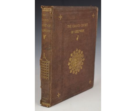
Proceedings principally in The County of Kent in connection with the Parliaments Called in 1640 edited by The Rev. Larking 1862 with portrait in gilt lettered cloth. The Hythe, Sandgate and Folkestone Guide with a Brief History of the Cinque-Ports printed by W. Tiffen 1818 second edition with 5 folding plates & engraved title in paper boards with illustrated label (binding worn and split). A Short Historical Sketch of The Town of Dover, and the Neighbourhood; containing a concise History of the Town and Castle 1828 sixth edition illustrated with 2 plates in boards (lacking spine cover). History, Gazetteer and Directory of the County of Kent containing a General Survey of the County etc by Samuel Bagshaw (c.1847) volume 1 only and lacking map. The History of Dover Castle by The Revd. Wm. Darell Illustrated with 10 Views and a Plan of the Castle (lacking the full-page views) printed for Hooper & Wigstead 1797 in boards (worn and detached). The Loss of The Ship "Northfleet" with Photographs of The Vessel, Romney Church, Captain and Mrs. Knowles etc, A complete account of all connected with the Sad Disaster 1873 in gilt lettered cloth (worn). An Account of The Grand Court of Shepway Holden on the Bredenstone Hill at Dover for the Installation of The Right Honourable Henry John Temple, Viscount Palmerston by Edward Knocker 1862 with several plates in gilt cloth. Dover Charters and Other Documents in the Possession of the Corporation of Dover by Rev. Statham 1902. Eminent Men of Kent by Jas. Simson 1893. A Saunter Through Kent with a Pen & Pencil by Charles Igglesden Illustrated Willis (volume 5 of the series) and Kentish Express for September 19 1874

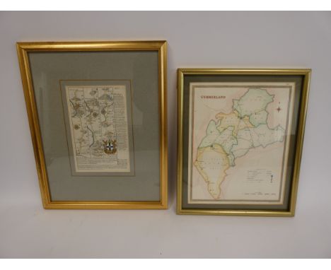
Lot 525
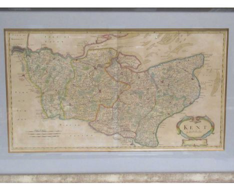
A Topographie or Survey of the County of Kent with some Chronological Historicall, and other matters touching the same: And the several Parishes and Places therein by Richard Kilburne of Hawkherst, printed by Thomas Mabb 1659 first edition with engraved portrait bound in full leather with raised bands and gilt lettered label (dated name top title page with covers worn and loose board). A Treatise of Gavelkind both Name and Thing shewing The True Etymologie and Derivation of the One, the Nature, Antiquary and Original of the Other with Observations of Kentish-men etc etc by William Somner with A Life of the Author printed for F. Gyles, J. Woodman, D. Lyon and C. Davis 1726 2nd Corrected Edition with engraved frontispiece in leather boards (worn & front board detached). An Epitome of County History, wherein the Most Remarkable Object, Persons and Events are briefly treated of etc Vol.1 KENT by C. Greenwood illustrated with a map [present] published 1838 bound in paper backed boards (worn) (3)
![[Pottinger] Travels In Beloochistan and Sinde; Accompanied by A Geographical and Historical Account of Those Countries with A](https://cdn.globalauctionplatform.com/83d1a739-8946-4acf-ab0e-aec300d84812/bb8e92fd-9652-45f5-98bf-aeca00fdb6f3/468x382.jpg)
Lot 528
[Pottinger] Travels In Beloochistan and Sinde; Accompanied by A Geographical and Historical Account of Those Countries with A Map [Lacking] by Lieutenant Henry Pottinger printed for Longman, Hurst, Rees, Orme & Brown 1816 first edition with hand-coloured frontispiece bound in half leather (worn and lacking map)


-
109182 item(s)/page