We found 109198 price guide item(s) matching your search
There are 109198 lots that match your search criteria. Subscribe now to get instant access to the full price guide service.
Click here to subscribe- List
- Grid
-
109198 item(s)/page


Lot 604
ROSE, W.S, attrib. Letters from the North of Italy addressed to Henry Hallam Esq. 2 vols. John Murray London 1819. 1/2 calf and marbled boards. 8vo. (215 x 140mm) plus DONALDSON, John William, Varronianus. A Critical and Historical Introduction to the Ethnography of Ancient Italy. 3rd Ed. Parker, London and Cambridge 1860. map, marbled end papers and edges. full calf with tooled coat for The Northern Church of England School. 8vo. (224 x 147mm) (2)


Lot 585
PLOT, Robert, The Natural History of Oxfordshire being an Essay toward the Natural History of England printed in Oxford 1677 with later coloured engraved title page. 358pp. Errata page and Index. 16 plates. Robert Montgomery b/p. full calf rebacked. red title and banded spine. small Fo. (350 x 208mm) plus Plots Map of Oxfordshire with cartouche and coloured armorials of notable families, 50 x 48cm, framed (2)

Lot 569
ROSCOE, Thomas, Wanderings in South Wales, Longman; Sim Kin; Bogue; Orr, London 1844. 8vo. with folding map. full tooled calf plus LIVINGSTONE, David, Missionary Travels and Researches in South Africa, Murray London 1857. 8vo. 1/2 calf marbled boards plus 25 further antiquarian leather bindings (27)


Lot 474
LINGARD, Rev. John, The Antiquities of the Anglo-Saxon Church. 2 vols. Newcastle 1806, with folding map. 8vo. (215 x 140mm), full 'burr' calf with red title plus a single volume. 2nd Ed. of the same title, 1810, with folding map, later bound in blue cloth. 8vo. plus a further 2 vol ed. 1806 with marbled boards plus CRULL, J, The Antiquities of St Peters Westminster, with fold out diagram and further plates, London 1709. in modern rebind (196 x 125mm) plus one associated title, Eric Gerald Stanley and other b/ps (7)


Lot 72
THOMAS KITCHIN Buckinghamshire, hand coloured engraved map 21.5 x 17cm, another similar of Oxfordshire, an Emmanuel Bowen map of Lincolnshire, an 18th century map of the Carthaginian Empire in Africa, by D'Anville 1738, and a hand coloured survey of the road from Oxford to Chichester and to Coventry and Derby (5)

Lot 584
PARISOT, V, Dictionnaire Geographique Universel, Pourrat Freres, Paris 1834. with fold out maps, charts etc., full calf red title, edges stained and bumped. 4to. (220 x 137mm) plus VOSGIEN, Nouveau Dictionnaire Geographique, last edition. Saintin Paris 1817, with fold out map and charts, full leather, much bumped and scuffed (2)

Lot 422
TURNER, Sharon (1768-1847) The History of The Anglo-Saxons, London 1799. 3 vols with fold out map. 1/2 calf marbled boards. 8vo. rubbed and worn. plus The History of the Manners...of the Anglo-Saxons, Longman, Hurst, Rees and Orme. London 1805. full calf. 8vo. plus KEMBLE, John M, The Saxons in England. 2 vols. Longman, London 1849. green cloth. 8vo. Eric Gerald Stanley b/ps (6)

Lot 609
AGRICULTURAL INTEREST:- TUKE, John, 'General View of the Agriculture of the North Riding of Yorkshire', McMillan, London 1800 with map. full calf. boards loose. 8vo. ex lib plus PITT, William, A General View of the Agriculture of Leicester, Richard Phillips, London 1809 with maps. 8vo. (235 x 160mm) rebound ex lib plus a 'General View of the Agriculture of the County of Suffolk', London 1797, full calf. splits etc. 8vo. plus County Reports for Somerset 1798, Lancaster 1795, Gloucester 1807 plus HARLEY, William, The Harleian Dairy System, London 1829 with portrait. 8vo. binding loose plus 3 associated titles, all ex lib with stamps etc (10)


Lot 424
TEN KATE, Lambert, 'Aenleiding Tot de Kennisse van het verhevene Deel der Nederduitsche Sprake'. 2 vols. Rudolph en Gerard Wetstein. Amsterdam 1723; engraved frontispiece. red and black title page and folding map. 1/2 calf with banded spine. 8vo. (250 x 210mm) plus TEN KATE, Lambert, 'Gemeenschap Tussen de Gottische Spraeke en de Nederduytsche'. Jan Rieuwertsz, Amsterdam 1710. uncut pamphlet form (215 x 175mm) (3)
Lot 771
AMUEL AUGUSTUS MITCHELL Persia, Turkey, Afghanistan and Belochistan, engraving, pub. Philadelphia c.1860, hand-coloured, 28 x 35cm; and four further similar to include American and European subjects; all mounted but unframed; and Thomas Brown - 'A New and Accurate Map of Turkey in Europe', pub. Edinburgh c.1801, hand-coloured, 29.5 x 34cm; and five further similar, all mounted but unframed (11)


Lot 493
SHERINGHAM, Robert, 'De Anglorum Gentis Origine Disceptatio', John Hayes and Edward Story, Cambridge 1670. full calf re-backed. (185 x 122mm) plus PINKERTON, John, 'A Dissertation on the Origin and Progress of the Scythians or Goths', Nicol London 1787 with folding map, full calf (212 x 140mm) plus two Antiquarian small format titles, Eric Gerald Stanley b/ps (4)


Lot 522
TURNER, Sharon, English Historian (1768-1847) The History of The Anglo Saxons. 2nd Ed. Longman et al, London 1807 with map (torn). 2 vols. 4to. much battered plus BONAPARTE, Lucien, Charlemagne an Epic Poem. 2 vols. 4to. Longman et al. London 1815. full calf, plus a reprint of Aesop's Fables (1609) 4to. boards loose plus Catalogus Librorum Manuscriptorum Bibliothecae Cottoniannae. Thomas Smith. Oxford 1696. with engraved portrait by R White, worm and damp damage. full contemporary calf. small Fo. plus two associated title (8)


Lot 501
THORKELIN, Grimr Johnson, Fragments of English and Irish History in two parts translated from the Original Icelandic with map. Nichols, London 1788, modern binding. 4to. plus O'HALLORAN, A General History of Ireland, 2 vols. London 1778. 4to. rebound plus 7 further Antiquarian titles - Anglo-Saxon studies etc (10)
Lot 791
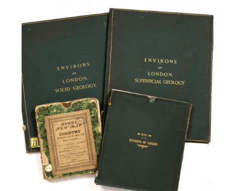
ORDNANCE SURVEY OFFICE, Colonel, Sir H James, Superintendent 1861, Environs of London Superficial Geology and Solid Geology, two 8 panel on linen coloured maps, 116 x 71cm folding into green cloth boards with gilt lettering and marbled end paper plus a large folding map 'Bacon's Library Map of the Environs of London' c.1850-1870. 28 coloured panels on linen with key and marbled end papers, 150 x 100cm approx. in green cloth slip case, ex Wimbledon Library stamps throughout, plus MOGG ‘New Map of Country 45 miles round London’ (4 in lot)
Lot 655
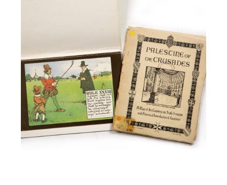
Palestine and the Crusades, A Historical Introduction and Gazetteer to Accompany a large fold out map under the direction of F.J. Salmon, Land and Surveys Palestine. Scale 1:350,000, 77 x 54cm approx. ex OCC Library with stamps together with 9 Pcs. The Rules of Golf after Chas Crombie, mod. reproductions (2)

Lot 680
NANSEN, Fridjof, Norwegian explorer (1861-1930), 'Farthest North', Newnes London 1898. 2 vols in one, numerous illus. map at end of Vol 1. torn out. half tooled green leather with red title. foxed and bumped. 8vo. (238 x 166mm) plus WYLLY, Colonel H.C., History of the 1st and 2nd Battalions The Leicestershire Regiment in the Great War, with signed portrait and maps inc. Mesopotamia. green cloth with gold tooled crest. 8vo. (252 x 190mm) (2)


Lot 776
Vinyl Records - Limited edition Boxset Queen, The Complete Works including Queen - QB1 1; Queen II - QB1 2; Sheer Heart Attack - QB1 3; A Night At The Opera - QB1 4; A Day At The Races - QB1 5; News Of The World - QB1 6; Jazz - QB1 7; Live Killers (V1) - QB1 8; Live Killers (V2) - QB1 9; The Game - QB1 10; Flash Gordon - QB1 11; Hot Space - QB1 12; The Works - QB1 13; Complete Version - QB1 14 - Includes Queen The Complete Works Booklet, 1971-1985 Tour Itinerary, World Map (1)
![Miniature Books - Fénelon [François de Salignac de la Mothe], Pious Reflections [...], With a sketch of his Life, London: Hen](https://cdn.globalauctionplatform.com/5745d17c-e0e6-43e2-8d16-ab46005b303f/0dbfd9ae-afab-43dd-a130-ab4c00ff32c6/468x382.jpg)
Lot 862
Miniature Books - Fénelon [François de Salignac de la Mothe], Pious Reflections [...], With a sketch of his Life, London: Henry Washbourn, 1829, pp: x, 104, engraved portrait frontispiece, contemporary printed wrappers as issued, 48mo (9.2cm x 6.1cm); Diamond Classics, Catullus, Tibullus et Propertius, Londonini, Impensis G. Pickering, 1824, pp: [6], 92, [2], engraved frontispiece, contemporary cloth (worn, split), 48mo (8.8cm x 5.4cm); Precious Stones: Diamonds, London: Rivingtons, 1882, contemporary black cloth, gilt in the Aesthetic Movement taste, 48mo (9cm x 6cm); Cartography, Bacon's Cycling Road-Map of England, No. 6, London: G.W. Bacon & Co Ltd., [n.d. c. 1900], red cloth pasted with pictorials, (faults); John Leech's Pictures of Life and Character: from the Collection of "Mr Punch", London: Bradbury, Agnew, & Co., [n.d. c. 1864], pictorial wrappers, 4to; King James Bible, four pages of a mid-17th century imprint, comprising dedication [2] and Translatours (sic) to the Reader [2], loose; a late 19th/early 20th century Italian rounded rectangular desk clip, decorated in polychrome with the Medici arms, on a field of Florentine scrolls, 16.5cm long, c. 1900; Ephemera - a Charles II ink MS on vellum indenture, dated 1670, 24cm wide; 19th century Plain Armorial bookplate, of Stephen Allaway, later inscribed in ink MS, 11.2cm x 7.5cm; a late 19th/early 20th century Italian rounded rectangular desk clip, decorated in polychrome with the Medici arms, on a field of Florentine scrolls, 16.5cm long, c. 1900; etc, [collection, 10]
![Holland. Ortelius (Abraham), Hollandiae Antiquorum Catthorum sedis nova Descriptio, Auctore Iacobo a Daventria, [1588], engra](https://cdn.globalauctionplatform.com/45651768-0840-4e6b-a25a-ab4401107d4e/3c6bab74-9c33-4002-91bf-ab450106e298/468x382.jpg)
Lot 122
Holland. Ortelius (Abraham), Hollandiae Antiquorum Catthorum sedis nova Descriptio, Auctore Iacobo a Daventria, [1588], engraved map orientated to the east, contemporary hand colouring, large strapwork cartouche, compass rose and numerous rhumb lines, slight dust soiling, central fold strengthened on verso, 355 x 490 mm, Spanish text on verso (Qty: 1)NOTESMarcel van den Broecke, Ortelius Atlas Maps, 79. 1st state.
Lot 453
Lang (Andrew) . The Blue Poetry Book, 1891, black & white illustrations, some light spotting throughout, all edges gilt, original gilt decorated blue cloth, boards & spine slightly rubbed, 8vo, together with Brassey (Anne) , In the Trades, the Tropics, & the Roaring Forties, 1st edition, 1885, colour folding map to front, black & white illustrations, some minor marks & toning, original gilt decorated cloth, boards & spine lightly marked & rubbed, 8vo, and Hart (H. Martyn) , The World of the Sea, circa 1878, monochrome plates and black & white illustrations, period inscription to head of the half-title, some light toning & offsetting, original gilt decorated blue cloth, boards & spines lightly rubbed, 8vo, plus other late 19th & early 20th century illustrated literature & reference, all original cloth, many gilt decorated, overall condition is generally good/very good, 8vo/4to (Qty: 3 shelves)
Lot 29
Gibson (John). Atlas Minimus, or a New Set of Pocket Maps of the several Empires, Kingdoms and States of the known World, with Historical Extracts relevant to each. Drawn and engrav'd from the Best Authors. Revis'd, corrected and improv'd by Eman[uel] Bowen, 1st edition, 1st issue, London: J. Newbery at ye Bible & Sun in St. Pauls Ch: Yard, 1758, 56 leaves (of 58: advertisement leaf and final blank discarded), engraved throughout, comprising frontispiece, title-page, preface leaf, index leaf, and 52 maps hand-coloured in outline, small worm-hole to inner margins throughout, spreading slightly in maps 51-2, text and images never affected, contemporary ownership inscription ('Anthony Fisher') to head of title, contemporary gift inscription ('Anthony Fisher, The Gift of Philip Mair') and pen-trials to front free endpaper, contemporary calf, covers detached, worn, 12mo (11.4 x 8.4 cm) (Qty: 1)NOTESESTC T163454; Roscoe J146A (1). This first issue contains an errata at the foot of the index leaf, correcting the caption on the map of Africa. Copies are often encountered uncoloured. Fourteen of the maps are devoted to the Americas.

Lot 99
* Cambridgeshire. Speed (John), Cambridgshire described with the devision of the hundreds, the Townes situation, with the Armes of the Colleges of that famous Universiti and also the Armes of all such Princes and noble men as have heertofore borne the honorable tytles & dignities of the Earldome of Cambridge, 1st edition, John Sudbury and George Humble, [1611], hand coloured engraved map, inset town plan of Cambridge, 24 heraldic shields to margins, long printer's fold affecting image, vertical margins trimmed to neatline and extended, central fold partially strengthenened on verso, mounted, framed and double glazed, English text on verso (Qty: 1)

Lot 45
Raleigh (Sir Walter). The History of the World, in Five Books ... Whereunto is added in this Edition, the LIfe and Tryal of the Author, London: for Robert White [and others], 1677, [46] 54 [i.e. 48] 376 393-660 577-708 737-885 [47] pp., engraved portrait frontispiece, additional allegorical title, letterpress title in red and black, 8 double-page maps, 'Mind of the Frontispiece' leaf discarded, one map (Sicily) browned, 18th-century half calf, rubbed, front board detached (with portrait remaining attached, torn in margin), rear joint cracked, folio (36.4 x 23 cm) (Qty: 1)NOTESESTC R33510; Wing R167.

Lot 107
* Durham. Saxton (Christopher), Dunelmensis Episcopatus qu comitatus est Palatinus vera et accurata descriptio, circa 1579, hand-coloured engraved map, decorative strapwork cartouche, arms of Elizabeth I and Thomas Seckford, 370 x 480 mm, mounted, framed and glazed (Qty: 1)NOTESThe first engraved map of the county of Durham.
Lot 434
Calvert (Albert F.) . Spain, 191, colour map frontispiece, 46 colour plates plus numerous black & white illustrations, original gilt decorated red cloth, spine lightly faded & rubbed, large 4to, plus Petrie (Graham) , Tunis, Kairouan & Carthage, 1908, 48 colour plates, some spotting throughout, original illustrated red cloth, spine lightly faded & rubbed to head & foot, 4to, and Tyndale (Walter [illustrator]) , Wessex, by Clive Holland, 1906, 75 colour illustrations plus map to rear, later inscription to front endpaper, some light spotting, original decorative blue cloth, boards & spine lightly rubbed to head & foot, 4to, plus other early 20th century & modern travel reference, including 33 volumes of A. & C. Black publications, all original cloth, some decorative, some in dust jackets, G/VG, 8vo/4to. (Qty: 6 shelves)
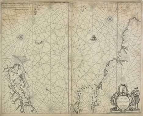
Lot 88
Atlantic Ocean. Jacobsz (Theonis aka Lootsman), Pascaert vande Carybes, Nieu Nederlandt, Brazil, de Flaemsche en sout Eylanden en de landen daer ontrent gelegen, Amsterdam, circa 1650, uncoloured engraved sea chart orientated to the east, two compass rose and numerous rhumb lines, some staining, central fold strengthened and repaired on verso, slight worming and areas of paper thinning and abrasion, repaired on verso, margins and corners frayed with slight loss, repaired on verso, 435 x 540 mm (Qty: 1)NOTESBurden 368. Although not in the best of condition this separately issued chart is scarce and important. It shows the Western Atlantic including the West Indies and contiguous parts of the North Eastern United States and Northern South America. The objective of this precursor map was to present in atlas form the most desirable information from the West Indische Paskaert maps of Willem Blaeu. It was much copied throughout the second half of the 17th century.
![* Cornwall. Saxton (Christopher & Kip William), Cornwall olim pars Danmoniorum, [1637], hand coloured engraved map, large](https://cdn.globalauctionplatform.com/45651768-0840-4e6b-a25a-ab4401107d4e/5525f190-67d1-4146-bbfb-ab450106d361/468x382.jpg)
![* London. Munster (Sebastian), Londin oder Lunden die Haupestatt in Englellande..., Basel, [1628 or later], hand coloured woo](https://cdn.globalauctionplatform.com/45651768-0840-4e6b-a25a-ab4401107d4e/d79147d5-2055-4fae-bc22-ab450106ec9a/468x382.jpg)
Lot 131
* London. Munster (Sebastian), Londin oder Lunden die Haupestatt in Englellande..., Basel, [1628 or later], hand coloured woodblock map with descriptive text in German below and on verso of map, slight staining and toning, 300 x 380 mm, mounted, framed and glazed (Qty: 1)NOTESHowgego 6, state 2. Howgego states that the 1628 edition should have the numbers 84 and 85 above the map which replaced lvii and lix. This example has the numbers 94 and 95 above the map - which is not described in Howgego - and may be from a later edition of the 'Cosmographia'.
Lot 179
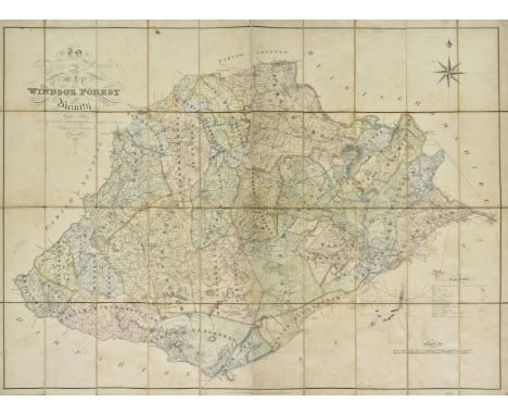
Windsor Forest. Walter (H.), To the Kings most Excellent Majesty This Map of Windsor Forest and its Vicinity from actual survey is humbly dedicated..., published August 1st by the Proprietor at Holyport near Maidenhead and E. Mogg London, 1st. edition, 1823, engraved large scale map with contemporary hand colouring, sectionalised and laid on linen, calligraphic cartouche, compass rose and table of explanation, near contemporary manuscript addition of railway lines and a pencil and watercolour plan of Chobham Common showing army encampments, slight staining and some dust and finger soiling, 920 x 1250 mm (Qty: 1)NOTESA rare separately published map of the environs of Windsor Forest from Staines in the West, Bagshot in the South, Twyford in the West and Maidenhead in the North. Walter is not recorded in Worms and Baynton-Williams. Copac lists only two institutional copies (British Library and Oxford University) and Worldcat only one (British Library).

Lot 119
Geological maps. Teall (J. J. H.), Geological Map of the British Islands. based on the work of the Geological Survey, 2nd edition, 1912, colour lithographic map, sectionalised and laid on linen, occasional pencil annotations, 830 x 620 mm. bound in contemporary cloth boards, faded and worn at extremities, together with Hughes (W.). G eological Map of Central and Western Europe, including the British Isles, France, Germany and the adjacent Countries, circa 1870, engraved map with contemporary hand colouring, sectionalised and laid on linen, slight dust soiling and staining, edged in green silk, 605 x 850 mm, with Geological Survey of England & Wales (publishers). Two untitled maps of the country around Cheltenham, 1871, two hand coloured engraved map, sectionalised and laid on linen, each approximately 650 x 795 mm, marbled endpapers, contained in a contemporary book-box with gilt heraldic crests to upper cover, gilt title to spine and an 'envelope style' lid, with another late 19th century unattributed geological map of England & Wales and another Geological Survey of England & Wales map of the country surrounding the Bristol Channel, bound in contemporary cloth boards, boards worn and faded (Qty: 5)
Lot 462
Yule (Henry) . The Book of Ser Marco Polo, the Venetian,..., 2 volumes, 1871, numerous colour & monochrome illustrations, folding map to rear of volume 1, folding colour plate to volume 2 front pocket, some light toning throughout, ex-library copy with associated marks, uniform original gilt decorated blue cloth, boards & spines slightly rubbed to head & foot, 8vo, together with Huntington (Ellsworth) , The Pulse of Asia, 1st edition, 1907, numerous monochrome illustrations, 'presentation copy' blindstamp to head of title & dedication pages, some light toning, original green cloth, boards & spine slightly rubbed to head & foot, 8vo, and Srinivas (M. N.) , Religion and Society among the Coorgs of South India, 1st edition, 1952, Oxford, 12 black & white illustrations, bookplate to front pastedown, contemporary inscription & ink stamp to front endpaper, some light toning, original blue cloth, 8vo, plus other late 19th & early 20th century India history, reference & related, mostly original cloth, G/VG, 8vo/4to (Qty: 6 shelves & a carton)
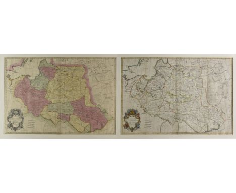
Lot 156
* Poland . Senex (John), Poland Corrected from the Observations Communicated to the Royal Society of London and the Royal Academy at Paris..., [1720 and later], engraved map with contemporary hand colouring, large uncoloured cartouche and mileage scale, slight creasing, occasional marginal repaired closed tears, 650 x 950 mm, mounted with another later edition with contemporary outline colouring and some later enhancement to the cartouche and mileage scale, double aperture mount, framed and glazed (Qty: 1)

Lot 389
Minton (John, illustrator). Time Was Away. A Notebook in Corsica, written by Alan Ross, 1st edition, London: John Lehmann, 1948, map frontispiece, black and white plates and illustrations and 8 colour lithographic plates by Minton, original cloth in pictorial dust jacket from a design by John Minton, a little chipped and split at edges, spine slightly browned, large 8vo (Qty: 1)

Lot 104
Danzig. De Leth (Hendrik), Plan en Profil der Beroemde Stadt Dantzig, derzelver Werders, en Omleggende Landen..., Amsterdam, circa 1740, hand coloured engraved plan of Danzig (Gdansk) and its environs with an engraved panorama of the city set into a floriate border below map, lower margin and central fold repaired and strengthened on verso, repaired marginal closed tear, slight overall toning, 505 x 500 mm (Qty: 1)NOTESA separately published city plan.


Lot 2
Anson (George). A Voyage round the World in the years MDCCXL, I, II, III, IV, 5th edition, London: for the author, by John and Paul Knapton, 1749, 42 engraved maps, charts and plates (spotted and toned), all but 1 folding (complete as list), one large folding chart with a couple of short closed tears, plate 41 close-trimmed at head (plate number cropped), directions to binder at rear, without folding map frontispiece often present, 19th century sprinkled half calf, rubbed, 4to (Qty: 1)
-
109198 item(s)/page