

World. Bullock (L. G.), United Nations Map of the World, John Bartholomew & Son Ltd. Edinburgh, 1944, colour-printed pictorial map, laid on linen, old folds, 670 x 915 mm, card endpapers, with an additional title and description, together with Children's Map of London, John Bartholomew & Son Ltd. Edinburgh, circa 1948, colour-printed pictorial map, laid on linen, old folds, 540 x 725 mm, card endpapers with a pictorial title and descriptionQTY: (2)NOTE:Leslie George Bullock was a civil servant who produced several pictorial maps for children. The map of the United Nations bears a close similarity to MacDonald Gill's map 'Time and Time Map of the Atlantic Charter'. Tim Bryars describes the map as "A wonderful example of postwar optimism" which seems perfectly apposite. The royalties from his map of London were made over almost entirely, to the benefit of Great Ormond Street Hospital for Sick Children.Further information on these maps and on Leslie Bullock can be found on both of the links below.Tim Bryars: https://bryarsandbryars.co.uk/leslie-george-bullock-cartoon-maps-for-children/Roderick Barron: http://barronmaps.com/leslie-george-bullock-1895-1971-designer-of-historical-maps/
We found 109182 price guide item(s) matching your search
There are 109182 lots that match your search criteria. Subscribe now to get instant access to the full price guide service.
Click here to subscribe- List
- Grid
-
109182 item(s)/page
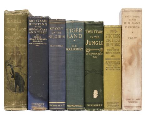
Inglis James). Tent Life in Tigerland, with which is incorporated sport and work on the Nepaul frontier, 1st edition, London: A. Hutchinson & Son, 1888, 22 chromolithograph plates, advertisements at rear, occasional light soiling, contemporary presentation inscription, hinges tender, bookplate of Alan Thornton, original pictorial cloth, spine and edges rubbed, small stain to spine, 8vo, together with Burrard (Major G.) Big Game Hunting in the Himalayas and Tibet, 1st edition, London: Herbert Jenkins, 1925, folding maps, half-tone illustrations, light spotting front and rear, bookplates of Alan Thornton and H.F. Prynne, contemporary presentation inscription, original cloth, spine faded with tear at foot, a few stains to covers, 8vo, plus Fletcher (F.W.F.) Sport on the Nilgiris and in Wynaad, 1st edition, London: Macmillan and Co., 1911, folding map, illustrations, untrimmed in original cloth, spine a little faded with tiny tear at head, 8vo, with 4 others including C.E. Gouldsbury's Tigerland. Reminiscences of Forty Years' Sport and Adventure in Bengal, 2nd edition, 1913, and Robert Baden-Powell's Pig-Sticking or Hog-Hunting, revised and enlarged edition, 1924QTY: (7)

Oxford. New (Edmund Hort), Christchurch, Oxford, Founded by Thomas Wolsey..., 1916, uncoloured photo-etching, laid on card, 460 x 670 mm, together with Loggan (David). Collegium St. Trinitatis, circa 1675, hand-coloured engraving, laid on card, 325 x 410 mm, mounted, with Monk (William). The Latin Chapel Christ Church, The Garden Gate of Trinity College [and] The Quadrangle of the University Press, 1901 - 03, together 3 uncoloured etchings, mount stained, each approximately 300 x 410 mm, mounted, with another 6 prints and engravings of Oxford, including examples by or after Stadler and Knight, plus Morden (Robert). Oxfordshire [1695 or later], hand-coloured engraved map, repaired closed tears, creased, 425 x 365 mm, mounted, and Brewer (H. W.). Birds-Eye View of Oxford, 1894, uncoloured photolithograph, trimmed to image with aperture mount for the key plate and title, several long closed tears affecting the image, one small hole, 290 x 885 mm, mounted, framed and glazedQTY: (13)

Bell (Walter Dalrymple Maitland). The Wanderings of an Elephant Hunter, 1st edition, London: Country Life/George Newnes, New York: Charles Scribner's Sons, 1923, title printed in red and black, half-tone illustrations, a few spots, original cloth, a few light marks, 4to, together with Lyell (Denis D.) The Hunting & Spoor of Central African Game, 1st edition, London: Seeley, Service & Co., 1929, monochrome illustrations, advertisements at end, original cloth, a few stains to covers, slight lean, 4to, plus Chapman (Abel). Savage Sudan. Its Wild Tribes, Big-Game and Bird-Life, 1st edition, London: Gurney and Jackson, 1921, map frontispiece, illustrations, top edge gilt, original cloth gilt, a few small light stains to lower cover, 8vo, plus W.B. Cotton's Sport in the Eastern Sudan from Souakin to the Blue Nile, 1912QTY: (4)NOTE:Czech pp. 23-24; 174-75; 60 & 67 respectively.
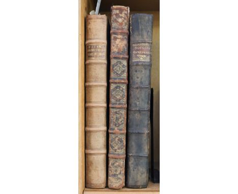
Patin (Charles). Relations historiques et curieuses de voyages, en Allemagne, Angleterre, Hollande, Bohême, Suisse, &c., Lyon: Claude Muguet, 1674, additional engraved title, letterpress with engraved illustration, engraved portrait, armorial headpiece, folding engraved map and five plates (2 folding), without free endpapers, contemporary calf, gilt decorated spine, worn at head of spine, 12mo, together with:[Addison, Joseph], Remarks on Several Parts of Italy in the Years, 1701, 1702, 1703, 1st edition, London: Jacob Tonson, 1705, few engraved illustrations of coins, bookplate of art historian Patricia Milne-Henderson (1935-2018) to upper pastedown, contemporary half calf, rebacked, 8voQTY: (2)

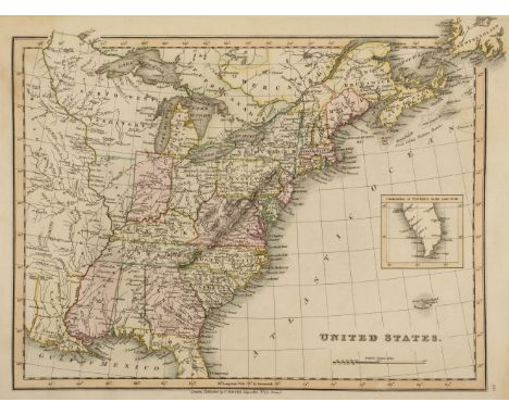
Scott (Jonathan, editor). The Arabian Nights Entertainments, 6 volumes, London: Longman, Hurst, Rees, Orme and Brown, 1811, engraved frontispieces (frontispiece and title detached in volume II), some light toning and offsetting, bookplates of Marcus Brown-Westhead, Lea Castle, later attractive tan calf gilt, two small wormed patches to volume VI lower cover, 8vo, together with 2 others: William Guthrie's A New Geographical, Historical and Commercial Grammar, 10th edition, 1787 (with 18 maps only, lacking World map), and Washington Irving's A History of New-York, from the beginning of the World to the end of the Dutch Dynasty, 1824 QTY: (8)

Polack (Joel Samuel). New Zealand: Being a narrative of travels and adventures during a residence in that country between the years 1831 and 1837, 2 volumes, 1st edition, London: Richard Bentley, 1838, folding engraved map, 6 engraved plates, a little minor spotting, original cloth-backed boards, spines a little faded, 8vo, together with Nicholas (John Liddiard). Narrative of a Voyage to New Zealand, performed in the years 1814 and 1815, in company with the Rev. Samuel Marsden, 2 volumes, 1st edition, London: printed for James Black and Son, 1817, half titles, engraved frontispieces, 3 engraved maps (2 folding), wood-engraved illustration, some offsetting and spotting, library stamps, top edge gilt, contemporary green half morocco, spines repaired, a little rubbed with some fading, 8vo, plus Charles Murray's Travels in North America during the years 1834, 1835 & 1836..., 2 volumes, 2nd edition, 1841QTY: (6)

Ruttledge (Hugh). Everest: The Unfinished Adventure, 1st edition, London: Hodder & Stoughton, 1937, 2 folding maps, illustrations, light spotting to endpapers, bookplate, original cloth, dust jacket, spine toned with small chips and tears at ends, small splits to joints, 8vo, together with Howard-Bury (C.K.) Mount Everest. The Reconnaissance, 1921, 1st edition, London: Edward Arnold, 1922, maps and half-tone illustrations, endpapers a little toned, original cloth, spine a little faded, lower corners bumped, 8vo, plus Norton (E.F.) The Fight for Everest: 1924, 1st edition, London: Edward Arnold, 1925, colour frontispiece, folding map, illustrations, some light spotting, original cloth, edges slightly rubbed, 8vo, with other mountaineering including William Martin Conway's The Alps from End to End, 1904, Edmund Candler's The Unveilling of Lhasa, 1905, Lehmann J. Oppenheimer's The Heart of Lakeland, 1908, J.B.L. Noel's Through Tibet to Everest, 1927, Hugh Ruttledge's Everest 1933, 1934 (2 copies), and H.W. Tilman's The Ascent of Nanda Devi, 1937 QTY: (23)

Mackenzie (Eneas). An Account of the Most Striking and Wonderful Events in the Life of Napoleon Bonaparte. From his sailing from Elba to his landing at St. Helena. With a description of the Battle of Waterloo and of the Singular Island to which the Ex-Emperor has been banished, Newcastle upon Tyne: Mackenzie and Dent, 1816, 2 plates (one folding), map to rear lightly damp-stained, early ownership inscription to upper margin of title, folding plate with a few closed marginal tears, lightly spotted, original brown paper wrappers, rebacked, worn, 8voQTY: (1)NOTE:Scarce, Copac can only trace four copies (Newcastle, NLS, Birmingham, Cambridge).
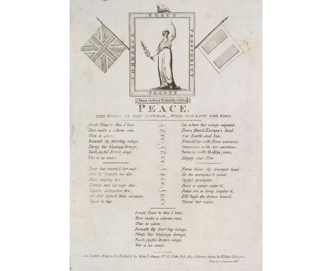
Napoleonic Broadsides. Peace, the words by John Luffman - Tune, God Save the King, engraved and publish'd by John Luffman, October 17, 1801, engraved broadside with allegorical illustration of French Revolutionary symbol Marianne holding an olive branch within a border captioned with 'Peace, Prosperity, Plenty, Commerce', flanked by the Union Flag and Tricolour, five verses, small closed tear to left margin and chip to top margin, small repairs to verso, slight soling, 8vo, 215 x 155 mm, together with two others similar broadsides with words by John Luffman: The British Volunteer, circa 1803, trimmed to plate-mark, small marginal hole & short closed tear, 195 x 140 mm, and The Ministers, [1800], close-trimmed, 1170 x 110 mmQTY: (3)NOTE:John Luffman (1751-1821) was an engraver and cartographer, best known for his A New Pocket Atlas and Geography of England and Wales, 1803, but also produced the same year A Map Intended to Illustrate the Threatened Invasion of England by Bonaparte. The first song 'Peace' was written after the Treaty of Amiens, signed on 1 October 1801, a brief peace treaty as hostilities soon resumed when Britain declared war on France on 18 May 1803.
Bindings. Memoirs of the Life and Adventures of Colonel Maceroni, 2 volumes, London: John Macerone, 1838, portrait frontispiece to volume 1, armorial bookplate and sticker of Edward Lloyd of Rhagatt to front pastedown, lightly spotted to preliminary and rear leaves, contemporary red half calf gilt, backstrips faded, rubbed, 8vo, together with:Napier (W.F.P). History of the War in the Peninsula, and in the South of France, new edition, 6 volumes, London: Thomas and William Boone, 1860, 19th-century gift inscription to front blank of volume 1, numerous plates, lightly spotted, armorial bookplate of Charles Heathcote to front pastedowns, marbled endpapers and pastedowns, all edges marbled, contemporary terracotta calf gilt, backstrips faded, rubbed, 8vo, withWilson (Robert). Private Diary of Travels, Personal, Services, and Public Events, 2 volumes, London: John Murray, 1861, half-titles, folding map to rear pocket of volume 1, advertisements to rear of volume 2, endpapers renewed, modern black half calf gilt, 8vo, with 9 others related QTY: (19)

Botta (Carlo). Italy, during the Consulate and Empire of Napoleon Buonaparte, 2 volumes in 1, Philadelphia: Tower & Hogan, 1829, half-title, spotting, untrimmed to fore and lower edge, endpapers renewed, modern blue half calf gilt, 8vo, together with:Napoleonic Wars. History of the Wars since the French Revolution, 2 volumes, London: Sherwood, Neely, and Jones, 1817, engraved frontispieces, 1 folding map, 2 plates, Grotius Society stamps to titles, spotted and toned, modern green cloth gilt, 8vo, withHughson (D). The Life of Napoleon Bonaparte, 3 volumes, London: J. Wallis, 1815, engraved frontispieces, numerous engraved plates, armorial bookplates of Francis Darwin to front pastedown, York public library stamps to preliminary leaves, spotted, modern brown half calf gilt, 8vo, with 33 others relatedQTY: (39)

De Segur (Philip). History of the Expedition to Russia, undertaken by the Emperor Napoleon, in the year 1812, 2 volumes, London: Treuttel and Wurtz, 1825, folding map, 5 engraved plates, hinges repaired, spotting, contemporary brown sprinkled calf gilt, rebacked, rubbed, 8vo, together with:Labaume (Eugene). A Circumstantial Narrative of the Campaign in Russia, London: Samuel Leigh, 1815, folding map frontispiece, half-title, spotted, fore and lower edges untrimmed, top edge marbled, modern beige half morocco, 8vo, withVon Muffling (Carl). History of the Campaign of the British, Dutch, Hanoverian, and Brunswick Armies, London: T Egerton, 1816, folding map, spotting, contemporary notations to rear blank, modern black half calf gilt, raised bands, 8vo, with 10 others relatedQTY: (14)

Forsyth (William). History of the Captivity of Napoleon at St. Helena, 3 volumes, London: John Murray, 1853, lithographic frontispieces, folding map to rear of volume 1, lightly spotted, contemporary red half morocco gilt, raised bands, rubbed, 8vo, together with:Clarke (Hewson). History of the War, 3 volumes, London: T Kinnersley, 1816, engraved frontispieces, volume 1 with additional engraved title, numerous engraved plates, folding plate of Waterloo torn resulting in loss, spotted and toned, modern brown half calf gilt, 4to, withHewetson (W.B). History of Napoleon Bonaparte, 3 volumes, London: Richard Evans, 1816, engraved frontispieces, numerous engraved plates, hinges tender, contemporary ownership inscriptions to titles and front free endpapers, lightly spotted, contemporary brown half calf gilt, worn, 8vo, with 11 others related QTY: (20)

Jones (Captain Lewis Tobias). An Historical Journal of the British Campaign on the Continent, in the year 1794; with the retreat through Holland, in the year 1795, 1st edition, Birmingham: printed for the author by Swinney & Hawkins, 1797, list of subscribers, folding engraved map hand-coloured in outline, list of subscribers, four engraved plans (including two folding, one with closed tears repaired, without loss), leaf E1 with minor archival repair to outer edge, modern terracotta half morocco gilt, 4toQTY: (1)

Bennet (Edward). Shots and Snapshots in British East Africa, 1st edition, London: Longmans, Green and Co., 1914, 2 folding maps contained in rear pocket, half-tone illustrations, light spotting front and rear, original cloth, spine faded, a little rubbed, 8vo, together with Decle (:Lionel). Three Years in Savage Africa, 2nd edition, London: Methuen, 1898, 5 maps, illustrations, 40 pp. publisher's catalogue at end, some spotting to endpapers, bookplates, original cloth, spine a little faded with small stains, 8vo, plus Millais (John G.) Far Away Up the Nile, 1st edition, London: Longmans, Green and Co., 1924, map and monochrome illustrations, some light spotting, endpapers toned, small presentation inscription, bookplate of Alan Thornton, original cloth, spine faded, large 8vo, with others similar including Notes on Sport and Ornithology, by Rudolf of Austria, translated with the author's permission by C.G. Danford, 1889, Tropics and Snows, by Reginald Burton, 1898, and The Rediscovered Country, by Stewart Edward White, 1915, QTY: (17)
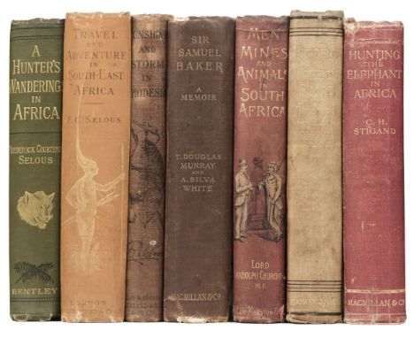
Selous (Frederick Courteney). A Hunter's Wanderings in Africa, being a narrative of nine years spent amongst the game of the far interior of South Africa, 2nd edition, London: Richard Bentley, 1890, folding map, plates and illustrations, bookplate of Alan Thornton and bookseller ticket at front, original cloth gilt, 8vo, together with Travel and Adventure in South-West Africa, 3rd edition, London: Rowland ward and Co., 1893, portrait frontispiece, folding map, illustrations, 4 pp. advertisements at end, bookplates, original cloth gilt, spine a little faded and rubbed at ends, 8vo, plus Sunshine and Storm in Rhodesia, 1st edition, London: Rowland Ward, 1896, maps and illustrations, previous owner signature to title, original cloth, spine browned, some toning to covers, 8vo, with four others: Sir Samuel Baker. A Memoir, by T. Douglas Murray & A. Silva White, 1895, Lord Randolph Churchill's Men, Mines and Animals in South Africa, 2nd edition, 1892, Incidents of Foreign Sport and Travel, by Colonel Pollok, 1894, and Hunting the Elephant in Africa, 1913 QTY: (7)
Montholon (Charles-Tristan). History of the Captivity of Napoleon at St. Helena, 4 volumes in 2, New York: E Ferrett & Co, 1846-47, contemporary gift inscription to front blank of volume 2, leaves toned, modern green half morocco gilt, 8vo, together with:Bain (Nicolson). A Detailed Account of the Battles of Quarte Bras, Ligny and Waterloo, 2nd edition, Edinburgh: Michael Anderson, 1819, large hand-coloured folding map, half-title, near-contemporary inscription to half-title, endpapers renewed, modern brown quarter morocco, 8vo, withFarie (Robert). Campaign in France in the year 1792, London: Chapman and Hall, 1849, cartographic frontispiece, armorial bookplate of Charles Wolseley, lightly spotted and toned, contemporary brown half calf, 8vo, with 22 others relatedQTY: (26)
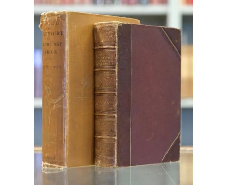
Selous (Frederick Courteney). Travel and Adventure in South-East Africa, 1st edition, London: Rowland Ward & Co., 1893, half-title, monochrome portrait frontispiece and illustrations, armorial bookplate of Baron de Spon to upper pastedown, original cloth, frayed at head & foot of spine, extremities rubbed, scuffed, large 8vo, together with:Selous (Frederick Courteney), A Hunter's Wanderings in Africa, being a narrative of nine years spent amongst the game of the far interior of South Africa, 1st edition, London: Richard Bentley & Son, 1881, half-title, wood engraved frontispiece, plates and illustrations, folding lithograph map, scattered spotting and occasional toning, armorial bookplate of Baron de Spon to upper pastedown, contemporary dark brown half morocco, spine faded, joints and extremities rubbed, 8voQTY: (2)

Napoleon. Notes on the Battle of Jena, London: T Egerton, 1827, 3 folding maps, advertisement leaf to rear, damp-stained, spotting, map to rear of volume torn with adhesive tape repair, endpapers renewed, fore and lower edge untrimmed, modern dark red half calf gilt, 8vo, together withGiraud (P.F.F.J). The Campaign of Paris, in 1814, London: Samuel Leigh, 1815, 2 folding maps (including frontispiece), all edges marbled, contemporary brown diced calf gilt, rebacked with original spine laid on, worn, 8vo, with 9 others relatedQTY: (11)

Shackleton (Ernest). South, The Story of Shackleton's Last Expedition 1914-1917, 1st edition, 1st impression, London: William Heinemann, 1919, half-title, colour frontispiece, black and white plates after photographs, folding map, errata slip tipped-in, contemporary ownership inscription to upper margin of front free endpaper, spotting to preliminary and rear leaves, pages toned, original blue pictorial cloth, slightly rubbed, 8voQTY: (1)NOTE:Attractive copy.
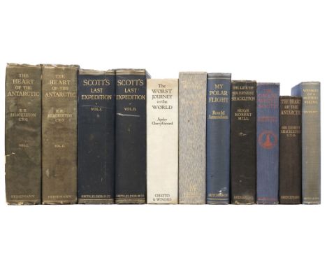
Shackleton (Ernest). The Heart of the Antarctic, 2 volumes, 1st edition, London: William Heinemann, 1909, half-titles, 3 folding maps to rear pocket of volume 1, numerous black and white illustrations, errata slip to volume 1, spotted and toned, original blue pictorial cloth gilt, top edge gilt, backstrips faded, marked and worn, 8vo, together with:Scott (Robert Falcon). Scott's Last Expedition, 2 volumes, 3rd edition, London: Smith, Elder & Co, 1913, half-titles, portrait frontispieces, 9 maps (some folding), numerous black and white plates, spotting, original blue cloth gilt, rubbed and marked, 8vo, withHanssen (Helmer). Voyages of a Modern Viking, 1st edition, London: George Routledge & Sons Ltd, 1936, half-title, portrait frontispiece, 5 black and white illustrations, double-page map, lightly spotted, near-contemporary gift inscription to front free endpaper, original blue cloth gilt, backstrip faded, lightly rubbed, 8vo, with 6 others relatedQTY: (11)
Patin (Charles). Imperatorum Romanorum Numismata ex aere mediae et minimae formae: descripta & enarrata, Paris: Apud Viduam Cramoisy Bibliopolam, 1696, [xxviii], 434 pp., including unnumbered index leaf at end, engraved portrait of the author, additional engraved title, title printed in red and black with large engraved device, 2 double-page engraved maps (Southern Europe and the Middle East), 6 full-page engraved plates, numerous engraved illustrations to text, printed bookplates of the London Numismatic Club and Patricia Milne-Henderson to front pastedown, contemporary panelled ful calf, 20th century antique-style calf reback, retaining original gilt title label, folio, together with Occo (Adolf). Imperatorum Romanorum Numismata a Pompeo Magno ad Heraclium ab Adolfo Occone olim congesta; nunc Augustorum Iconibus, perpetuis Historico-Chronologicis notis, pluribusque additamentis illustrata, & aucta...studio, et cura Francisci Mediobarbi Biragi, Milan: Ex Typographia Ludovici Montaie, 1683, lacking engraved allegorical frontispiece, title printed in red & black with engraved vignette, numerous small engraved illustrations to text, 18th century engraved bookplate of Sir Ashton Lever to front pastedown, contemporary mottled full calf, rebacked and corner repairs, retaining original gilt title label to spine, folio, plus Foy-Vaillant (Joseph). Numismata Aerea Imperatorum, Augustarum, et Cæsarum, in coloniis, municipiis, et urbibus jure latio donatis, ex omni modulo percussa, 2 parts bound in one, [2nd edition], Paris: Daniel Horthemels, 1695, titles printed in red and black with engraved vignette to each, numerous engraved illustrations to text, single folding engraved map by Auguste Lubin, bookplate of Patricia Milne-Henderson to front pastedown, contemporary mottled full calf, gilt spine, heavily rubbed and some wear, with joints cracked, folioQTY: (3)NOTE:Dekesel F-60 (Foy-Vaillant).Provenance: (Occo only) Sir Ashton Lever (1729-1788); (all three titles) Patricia Milne-Henderson (1935-2018), art historian.Ashton Lever of Alkrington (1729-1788) was only 13 when he inherited the estate of his father Sir Darcy Lever in 1742. After graduating from Corpus Christi College, Oxford he devoted himself to forming a collection of live birds, accumulating an remarkable aviary of around four thousand birds. He subsequently amassed one of the largest natural history collections of the later eighteenth century, which was eventually put on public display at his private museum, the Holosphusikon, in Leicester Square, London in 1775. A distinguished collection by any standards, the approximately 27,000 objects included a number of natural specimens not to be found elsewhere in Britain, a substantial amount of ethnographic material from Captain Cook’s second and third voyages, as well as British and foreign antiquities.
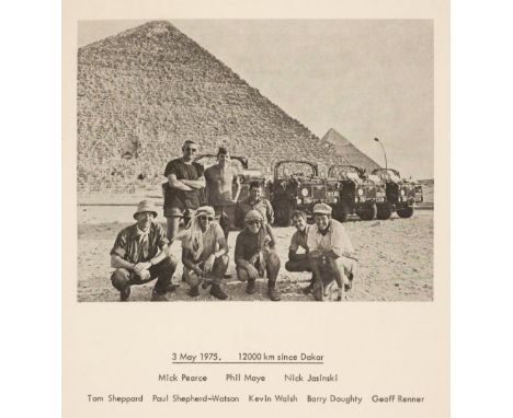
Sheppard (Squadron Leader T.H.). Joint Services West East Sahara Expedition 1975, Report, sole edition, Uxbridge, Middlesex, Royal Air Force, 18 September 1975, [xiv] 10, [175] pages, printed title, frontispiece (a photograph of the expeditionary team and their jeeps taken 3 May 1975), folding map of North Africa, showing the expedition route, 2 folding photographic maps, several diagrams and charts etc., including photographs at rear, original printed wrappers, rubbed and some marks, with minor fraying to extremities, with red plastic spiral binder to spine, 4toQTY: (1)NOTE:Rare. No copy on WorldCat. Library Hub Discover locates one copy only (Royal Society Library).The summary only of this report was published in the Geographical Journal the following year (volume 142, Part 2, July 1976, pp. 201-215). The Joint Services West East Sahara Expedition, comprising eight men and four 1-tonne Land Rovers, completed the first crossing of the Sahara from the Atlantic to the Red Sea through the Mauritanian ‘Empty Quarter’ between 25 Jan and 3 May 1975. The aims of the expedition were first, to make the first complete lateral crossing of the Sahara and the skeletally mapped deserts of the north-west Sudan and to provide a detailed topographic traverse; second, to carry out a gravity measurement under the auspices of the University of Newcastle upon Tyne and the Royal Society’s British National Committee for Geodynamics; third, to make rock, lizard and snail collections for appropriate departments of the British Museum (Natural History); fourth, to try new methods of desert navigation based on sun compass, astro-fixes and dead reckoning with an HP65 programmable pocket calculator; fifth, to provide user assessment of the first production 101in wheel-base, 1-tonne military Land Rover over challenging terrain; and last, since the expedition’s financial survival depended on it, to produce a commercially viable film for television or cinema use. Appendices give details of fuel consumption and planning, and of the scientific programme.
Smith (Charles). Smith's New General Atlas containing distinct maps of all the principal empires, kingdoms & states throughout the world arranged according to the General Treaty signed in Congress at Vienna, with considerable additions, London: C. Smith, Mapseller Extraordinary to His Majesty, 1830, engraved title, printed leaf of contents, single-page engraved table of mountains and rivers, double-hemisphere world map, double-page world map on Mercator's Projection, single-page chart of the voyages and travels of Captains Ross, Parry and Franklin by W.R. Gardner, and 43 hand-coloured maps on 56 sheets (some double-page, and map of India on 4 sheets), some minor marks, mainly to margins, light waterstain to foot of inner margins towards front of volume, folding map of India torn along folds, generally without loss (except for blank outer margin to lower right), inner hinges with later restrengthening, contemporary calf-backed marbled boards, worn, with later plain leather restoration, folioQTY: (1)

Thomson (John). A New General Atlas, consisting of a series of geographical designs on various projections, exhibiting the form and component parts of the Globe; and a collection of maps and charts, delineating the natural and political divisions of the empires, kingdoms, and states in the World. Constructed from the best systematic works, and the most authentic voyages and travels. With a memoir of the progress of geography, a summary of physical geography, and a consulting index to facilitate the finding out of places, Edinburgh: Printed by George Ramsay and Company, for John Thomson and Company, Edinburgh; Baldwin, Cradock, and Joy, London; and John Cumming, Dublin, 1817, printed title with some spotting, dedication to Alexander Keith of Dunottar and Ravelston, folding comparison plate, index and 22 pages of introductory text and 22 pages of a consulting index, 74 engraved double-page and folding maps (complete), all with contemporary outline colouring, some off-setting and slight spotting, each map with a small contemporary paper numeral pasted to the upper right corner, later front and rear blanks, marbled endpapers, hinges strengthened, contemporary half morocco gilt, rebacked but retaining the original spine, boards a little scarred, folio (560 x 435 mm) QTY: (1)NOTE:The largest atlas published in Scotland at the time, Thomson's atlas is distinguished by it's map of Europe in four sheets, the several sheets devoted to the major islands of the West Indies, as well as fine detailed maps of the Arabian peninsula, Japan and Korea, and Australia.

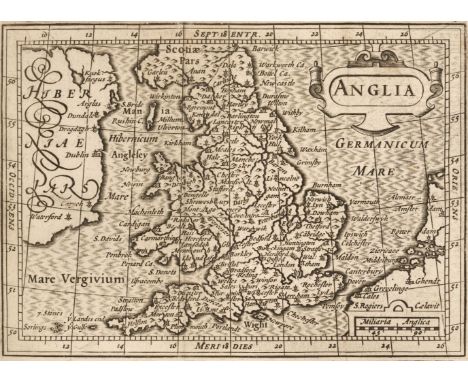
Camden (William). Guili. Camdeni Viri Clarissimi Britannia, sive florentiss Regnorum Angliae, Scotiae, Hiberniae, Insularumq Adiacentium ex Intima antiquitate Descriptio, Amsterdam: Guilielmum Blaeu, 1639, title with woodcut printers device and near-contemporary ownership signature, 19 uncoloured folding maps, the first map of the British Isles frayed along old folds with slight loss, a few maps with some fraying to the margins, some creasing and dust soiling throughout, index bound at rear, pastedowns frayed and split and partially detached from the boards, hinges and joints weak, upper joint partially split, contemporary calf gilt, worn and frayed at extremities, 12moQTY: (1)NOTE:Chubb. 55.

Cary (John). Cary's New and Correct English Atlas: Being a New set of County Maps from Actual Surveys..., Jany. 1st. 1792, title page and dedication dust-soiled and stained, general map of England & Wales, advertisement and contents list, 47 engraved maps (complete as list) with contemporary outline colouring, each map with a tissue guard and a page of descriptive text, slight offsetting, indexes bound at rear, upper hinge and joint weak, contemporary half calf gilt, rubbed and worn, 4toQTY: (1)NOTE:Chubb CCLXI.
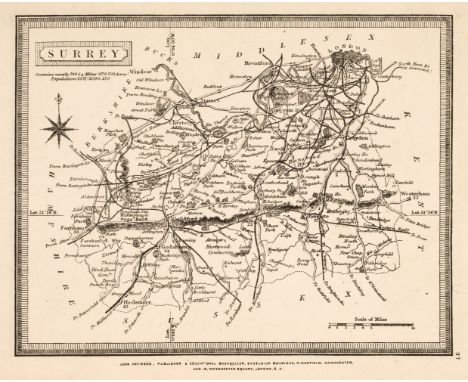
Heywood (John, publisher). The Travelling Atlas, of England & Wales, with all the Railways & Coach Roads, The Cities, Towns, Parks & Gentlemen's Seats..., Manchester [cover-title], c.1881, folding map of England & Wales, and 44 (complete) uncoloured lithographic maps of English counties, North & South Wales, printed back-to-back, variable spotting, publisher's paper wrappers, front cover with decorative calligraphic vignette title, wrappers a little frayed and dust-soiled, some spotting and toning, rear cover marked, slim 8vo, together with: Cruchley (George Frederick, publisher), Cruchley's County Atlas of England & Wales shewing all the railways & stations ..., London, 1875, 46 (of 47, without Suffolk) double-page maps with contemporary hand-colouring, several splitting at fold, Norfolk with crude fold repair to recto, occasional minor stains (mainly at fore-edge), title & index repaired at gutter, later endpapers, contemporary cloth, rebacked, original spine relaid, rubbed with some wear to extremities, 8vo, plus: Letts (Son & Co., publishers), Letts's Popular County Atlas, London: 1884, numerous chromolithographed maps, spotting to fore-edge and at front, first few leaves edge-frayed (few previous repairs) with some marginal staining, front free endpaper replaced, contemporary maroon half morocco gilt, rubbed, few minor marks, front cover with gilt-stamped title and armorial enhanced with colour, folio, and one other similar: Stanford's Parliamentary County Atlas and handbook of England and Wales, 1885QTY: (4)NOTE:Sold as a collection of maps, not subject to return.
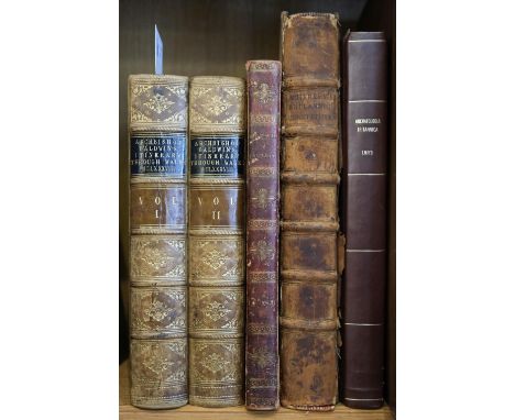
Hoare (Richard Colt). The Itinerary of Archbishop Baldwin through Wales, A.D. MCLXXXVIII, by Giraldus de Barri; translated into English, and illustrated with views, annotations, and a life of Giraldus, by Sir Richard Colt Hoare, 2 volumes, London: William Miller, 1806, half-titles, engraved frontispiece (vol. 1 frontispiece damp stained), numerous plates and folding map, title to first volume with ownership signature of J.B. Lloyd Philipps of Penty Park [Pembrokeshire], contemporary calf, gilt decorated spines with contrasting labels, extremities slightly rubbed, 4to, together with:Acherley (Roger), The Britannic Constitution: or, the fundamental form of government in Britain..., London: printed for A. Bettesworth, J. Osborn, and T. Longman..., 1727, title in red & black, front pastedown with armorial bookplate of the Hon. George Baillie, contemporary calf, joints split, worn, folio,Caradoc of Llancarfan (Saint), The Historie of Cambria, now called Wales: a part of the most Famous Yland of Brytaine, written in the Brytish Language... trans. into English by H. Lloyd... corrected, augmented & continued... by David Powel, London: reprinted for J. Harding, 1811, woodcut illustrations, upper pastedown with armorial bookplate of Richard Snead Cox of Eaton Bishop, contemporary red morocco, gilt decorated spine, gilt crest to upper board and monogram JS to lower board, joints rubbed, 4to,Lhuyd (Edward), Archaeologia Britannica, giving some account additional to what has been hitherto published, of the Languages, Histories and Customs of the original inhabitants of Great Britain: from collections and observations in travels through Wales, Cornwal[sic], Bas-Bretagne, Ireland and Scotland, volume 1: Glossography [all published], Oxford: printed at the Theatre for the author, and sold by Mr. Bateman, London & Jeremiah Pepyat, Dublin, 1707, incomplete with all after Dd2 provided in loosely inserted photocopy facsimile (leaves Ee1-Ii2), title with repaired closed tears, some damp staining and dust-soiling mostly at front of volume, modern quarter calf, folioQTY: (5)
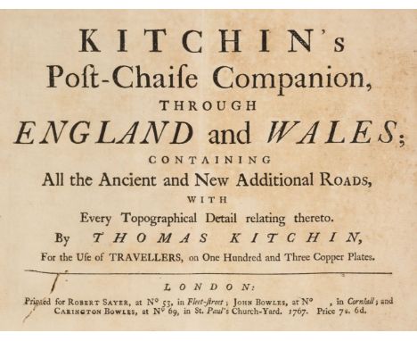
Kitchin (Thomas). Kitchin's Post-Chaise Companion through England and Wales; Containing all the Ancient and New Additional Roads...., John Bowles, Carington Bowles and Robert Sayer, 1767, title page stained, index of cities and towns, table of crossroads and an uncoloured engraved general map of England & Wales, 103 (complete) uncoloured engraved strip road maps on 51 sheets, printed, back to back, slight staining throughout, slight worming to the first five leaves, later endpapers, but retaining one old endpaper and one limp morocco wrapper, modern cloth gilt, oblong 8voQTY: (1)NOTE:Chubb. CXLI. A re-issue of John Senex's 'Actual Survey of all the Principal Roads of England and Wales..,' first published in 1719.
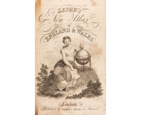
Leigh (Samuel). Leigh's New Pocket Road Book of England and Wales and part of Scotland..., 1825, frontispiece of the price of posting, additional decorative half-title and preface, 55 uncoloured engraved maps, additional half-title and a folding map of England & Wales, index and publisher's advertisement bound at rear, near-contemporary ownership signatures to the front pastedown and front free endpaper, hinges strengthened, contemporary morocco gilt, re-backed but retaining the original spine, 12mo, together with Lewis (William). Lewis's New Traveller's Guide and Panorama of England and Wales..., 1835, frontispiece of a map of England & Wales, title page, preface, contents and list of Mail coaches, 42 (complete as list) uncoloured engraved maps, one folding (Yorkshire) some spotting and staining throughout, hinges strengthened, some juvenile scribbling to the pastedowns and endpapers, contemporary cloth with publisher's printed label to the upper siding, re-backed but retaining the original spine, 8vo, with Aikin (John). England Delineated; or a Geographical Description of every County in England and Wales..., J. Johnson and T. Bensley, 1803, frontispiece of a folding engraved map of England & Wales and 43 engraved county maps, index bound at rear, hinges strengthened, later rear endpaper, contemporary calf, re-backed, bumped and with slight wear to the extremities, 8voQTY: (3)

Buchon (Jean Alexandre). Atlas Geographique, Statistique, Historique et Chronologique des Deux Ameriques et de Iles Adjacentes; Traduit de l'Atlas Execute en Amerique d'Apres LeSage..., Paris. J. Carez, 1825, title page, dedication and contents list, 63 (complete as list) maps, comparison plates and chronological tables including 51 double-page engraved maps with contemporary hand-colouring, a few maps with slight toning, printer's fold to the map of Peru, marbled endpapers, 20th century half calf over contemporary marbled boards, folioQTY: (1)NOTE:A French edition of Carey and Lea's 1822 "A Complete Historical, Chronological, and Geographical American Atlas".
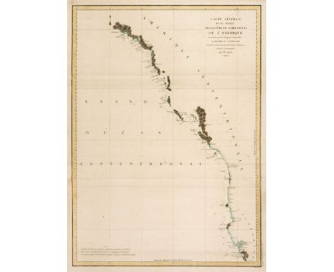
North America. Dagelet (M.), Carte Générale D'une Partie De La Côte Du Nord-Ouest De L'Amérique..., circa 1797, hand-coloured engraved sea chart originally published in 'Atlas de Voyage de la Perousse', old folds, slight spotting, 690 x 500 mmQTY: (1)NOTE:A detailed map of the Northwest Coast of North America, extending from Mount St. Elias in Alaska in the north to Monterey Bay in the south.

Americas. Bertius (Petrus), Carte de l'Amerique Corrigée, et augmentée dessus toutes les aultres cy devant: Faietes Lannee,1646, hand coloured engraved map, strapwork cartouche and 2 inset maps of the polar regions, 380 x 495 mmQTY: (1)NOTE:Philip D.Burden, The Mapping of North America, 209, state 3. A separately published map of America, based upon Jodocus Hondius's earlier map of 1618.

Americas. Homann (J. B.), Totius Americae Septentrionalis et Meridionalis novissima repraesentatio..., published Nuremberg, circa 1720, engraved map with bright contemporary outline colouring, large uncoloured allegorical cartouche, insular California, central fold repaired at base, 495 x 580 mmQTY: (1)
Bacon (G. W., publisher). Bacon's Large Scale Atlas of London and Suburbs (Revised Edition) with an Alphabetical Index, circa 1910, title page and contents list, 21 (only) double-page and folding social, geographic and industrial maps, some maps excised and loose, and a 34 sheet map of greater London, slight spotting and occasional closed tears, hinges weak, publisher's half morocco gilt, worn and frayed, folio, together with Camden (William). Britannia: or a Chorographical Description of Great Britain and Ireland, together with the Adjacent islands..., 2 volumes, 1772, portrait frontispiece, with later colouring in a juvenile hand, titles printed in red & black, 15 (only) uncoloured engraved double-page maps by Robert Morden, numerous engraved plates, contemporary calf, rebacked, worn at extremities, folio, with Philip (George & Son). Philip's Atlas of the Counties of England, 1883, 48 double-page colour lithographic maps, upper hinge cracked, all edges gilt, publisher's half morocco gilt, worn and rubbed, folio, plus Bacon (G. W. publisher). New Large Scale Ordnance Atlas of the British Isles, circa 1890, title page with a near-contemporary ownership signature, 102 (of 104) double-page lithographic maps, slight water staining, all edges gilt, publisher's half morocco gilt, worn, rubbed and water stained, folio, with another copy similar, with one other similar and Dugdale (James). The New British Traveller, or Modern Panorama of England & Wales, 4 volumes, J. Robins & Co. 1819, allegorical frontispiece, additional vignette half-titles, folding engraved map of England and Wales with long closed tears affecting the printed image, 45 uncoloured engraved maps by J. Neele and 43 (only) uncoloured engraved plates, contemporary ownership signature to front endpaper, contemporary marbled calf gilt, several boards detached or near-detached, rubbed and worn, 4to, with Bastien (J. Fr.) Dictionnaire Géographique Portatif...., de Laurent Echard par Vosgien..., 2 volumes, Brussels, 1792, one (only) uncoloured folding engraved map of Europe, contemporary mottled calf with gilt decorated spines, bumped and worn at extremities, 8voQTY: (13)NOTE:Sold as a collection of maps, not subject to return.
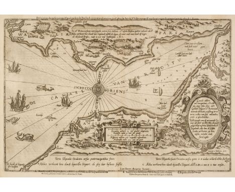
Bristol Channel. Waghenaer (Lucas Janszoon), Canalis Celebris vel Navigationis a Bristovio atque totius situs inter Galliam Belgicam et Britannicam accurata delineatio eiusdemque terrae verus vultus cum suis miliaribus ventis ac ascendentibus...., Cornelius Claesz [1590], uncoloured sea chart, engraved by Johannes van Doetichum for Waghenaer's sea-atlas, the 'Spieghel der Zeevaerdt', title repeated in Dutch and again, above the map in French, decorated with a large compass rose and numerous rhumb lines, sea monsters and sailing galleons, slight staining to the margins but not affecting the printed image, French text on verso, 360 x 520 mm, 590QTY: (1)NOTE:The first printed sea chart of the Bristol Channel which was first published in 1588. The map starts on the north Cornish coast at Padstow and clearly shows Barnstable, Ilfracombe, Combe Martin, Minehead, Dunster, Watchet and up the channel to Bristol. The south coast of Wales starts at Pembroke in the west and shows, Tenby, Swansea, Cardiff, Newport and Chepstow.

British Isles. A Collection of 46 maps, 17th - 19th century, engraved and lithographic maps including Bowen (Emanuel). A New and Accurate Map of Great Britain & Ireland, together with their Respective Islands..., 1752, hand-coloured engraved map, large maritime cartouche, 345 x 425 mm, together with Briet (Phillipe). Albion seu Britannia Maior, Le Royaume de la Grande Bretaigne, [and] La Vraye Angleterre Dicte Aultrement Loegrie [1648], together three uncoloured engraved maps, each approximately 195 x 145 mm, with Brion de la Tour. L'Angleterre divisée en 5 Grandes Parties..., Paris, 1786, engraved map with contemporary outline colouring, floriate margins, 285 x 315 mm, plus Bowles (Henry). Bowles's New Medium Map of England and Wales, Divided into their Counties..., [1795], engraved map with sparse outline colouring, some dust soiling, slight creasing, 325 x 225 mm, with another 40 maps of the British Isles and England & Wales, including examples by or after Bodenehr, Beer/Hoffman, Bowen (Emanuel & Thomas), Bayly, Bacon, A & C Black, Buffier, Badeslade & Toms, Barlow, Brion de la Tour, Burghers, Puffendorf/Nolin, Blondeau, Bell, Bertholon, Barlow, Hinton, Bickham, Becker, Finley & Fosset, occasional duplicates, various sizes and condition QTY: (46)
![British Isles. Homann (Johann Baptist), Magna Britannia complectens Angliae, Scotiae et Hiberniae Regna...., Nuremberg [1713]](https://cdn.globalauctionplatform.com/e9dc0ac2-559f-4025-a874-ae7e01100a9c/7917f7b3-5ed7-444a-aead-ae7f00f6bdd1/468x382.jpg)
British Isles. Homann (Johann Baptist), Magna Britannia complectens Angliae, Scotiae et Hiberniae Regna...., Nuremberg [1713], engraved map with contemporary outline colouring and some later enhancement to the cartouche, very slight staining, 485 x 570 mm, with another example similar, but with Queen Anne's portrait replaced by that of George IQTY: (2)NOTE:R. W. Shirley. Printed Maps of the British Isles, 1650 - 1750, Homann 2, states 2 & 4.
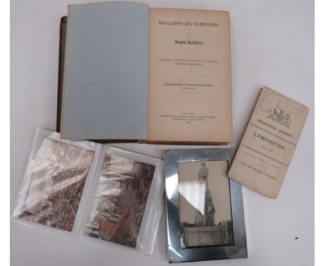
WW1 Period Military Postcards 30 various coloured and black and white postcards including various bombed towns and villages. Together with modern framed postcard of a German memorial ... 1906 dated Ordnance Survey map of Lymington with stamp for Staff Officer For Defence Portsmouth ... """"Regulations & Instructions For The Royal Artillery 1850"""". Leather covered book. Spine damaged and front cover loose. PAYMENT BY BANK TRANSFER ONLY

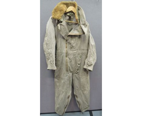
WW2 RAF 1941 Pattern Sidcot Flying Suit khaki green canvas, full suit. Side mounted, open end map pocket to the chest. Side fitted body zip. Upper legs with open top pockets. Lower legs with zip openings and electrical terminals. Cuffs with short zips and electrical terminals. Rear waist with tightening belt. Collar complete with detachable, synthetic fur collar. Internal issue label with size 4 label. Minor wear. PAYMENT BY BANK TRANSFER ONLY


THE ROYAL RIVER FROM SOURCE TO THE SEA; signed and inscribed by Sydney B Russell and dated 01/01/1901; THE NINE AGES OF JUSTERINI'S, in slip case, 1999; STANLEY (A), SINAI AND PALESTINE, with folding map, 2nd impression, HARPER (H); WALKS IN PALESTINE, 1894; an annotated paragraph bible with maps and plates, 1856 and an atlas (6)

SCOTT (CAPTAIN R.), THE VOYAGE OF THE ‘DISCOVERY’; two volumes, with black and white plates and folding map to the back of each, pictorial blue boards, London, Smith Elder & Co. 1905; THE SOUTH POLAR TIMES VOL III only (3).Additional InformationAll with general wear and scuffs throughout the surface, and the pictorial image on the front cover of The Polar Times has three spot marks to the upper section and some surface scratches. Internally some browning and some foxing.


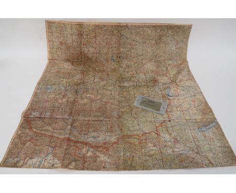
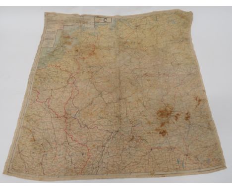
AIREYS RAILWAY MAP OF ENGLAND AND WALES 'MC CORQUEDALE AND CO 1903 TOGETHER WITH MAP OF THE COALFIELDS OF THE NORTH MIDLANDS, THE SOUTH MIDLANDS BY W. & AK JOHNSTON- SECTIONAL MAPS ON LINENThere is a name annotated to the back of the map but no names to the back of the map no obvious splits or tears but some slightly dirty surfaces from use


-
109182 item(s)/page