We found 109198 price guide item(s) matching your search
There are 109198 lots that match your search criteria. Subscribe now to get instant access to the full price guide service.
Click here to subscribe- List
- Grid
-
109198 item(s)/page


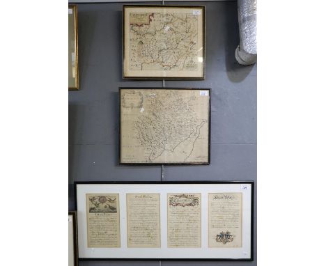
Lot 149
Saxton and Kip, original map of 'Caermardi (sic)', together with Robert Morden original map of the county of Monmouth, and a framed four panel text entitled 'South Wales, to avoid being tedious we shall describe the twelve counties of Wales under two divisions only etc..'. Framed (3) (B.P. 21% + VAT)


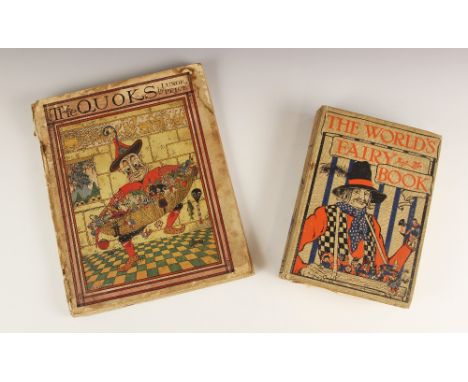
Lot 236
Price (Luxor), THE QUOKS, first edition, car boards, illustrated cover, alphabet checkerboard endpapers, map frontispiece, monochrome and colour plates throughout, W & R Chambers Ltd, London 1925; with THE WORLD'S FAIRY BOOK, first edition, illustrated by Monro S. Orr, cloth boards with embossed illustrated cover, colour frontispiece, colour plates throughout, George G. Harrap & Co Ltd, London 1930 (2) (at fault)


Lot 78
Bernhard Moritz, Bilder aus Palästina, Nord-Arabien und dem Sinai, comprising 106 plates after photographs of the Middle East, including the holy sites at Mecca Berlin, Dietrich Riemer, 1916106 plates after photographs mounted on to 50 card mounts with printed captions and dates in German, mostly two per mount, the images of varying sizes, numbered 1-100 (1-100 and 16a, 59b, 60a, 72a and 95a, one map, numbered 63a), 10 bound leaves (16 pages) of accompanying text in German, loose as issued in publisher's cloth-backed decorative portfolio boards, gilt-lettered Nord-Arabien und Sinai on upper cover, covers with printed decoration in the style of a Mamluk binding, oblong folio, title mount inscribed in ink R. Tschudi[?] portfolio 310 x 410 mm.Footnotes:A rare photographic record of the major sites and geographic features in Saudi Arabia, Jordan, Syria, Egypt and Palestine. The original photographs were taken for the most part by Moritz between 1905 and 1915, but some by Turkish friends in areas where he was prohibited from going. The subjects consist of:Jerusalem.Landscape views near Jericho and in Jordan.Deraa and other locations in Syria.Bedouin camps in east Jordan.Petra and the landscape nearby.Desert views in the Hejaz.Personnel building the Hejaz Railway between Damascus and Mecca and Medina.One printed map of Medina, accompanying views of the town, including the Mosque of the Prophet and the progress of the Mahmal in 1914.Views of Mecca, including the Ka'ba, and a pilgrim camp near Mount Arafat.Street scenes in Jeddah.Aqaba.Desert views in Sinai, oases, wadis and Christian monastic buildings.Moritz (1859-1939) was an Arabist and archaeologist who from 1896 to 1911 was in charge of the Khedival Library and Archive in Cairo, publishing a seminal work on Arabic paleography in 1905. He made several research trips to the Sinai and Hejaz.For further information on this lot please visit Bonhams.com


Lot 111
18th century Robert Morden hand tinted map, The County Palatine of Lancaster, 42.5cm x 37cm; After Estra Clark (British 1904-1993, Historic York, map pub. Ben Johnson & Co, York 1947, 37cm x 45cm; After Blaeu Arania, Insula in aestuario Glottae, Theyse of Arren in the Fyrth of Clyd, 37cm x 50cm; The British Isles educational map on plastic (4)

Lot 489
William Kip,Devoniae,a hand-coloured county map,30x34cm,and Christopher Saxton & William Kip, Lecestriae Comitatus, hand coloured map, 28x36cm.Qty: 2Condition report:The colours are rather faded on both maps, particularly the pale pinks, blues and yellows. Please see additional uploaded images.


Lot 542
Edwin Law after Meissonier, Gentleman at a writing table, etching on silk, image 30x20cm; a print after William Hogarth, The Politican, etched by Sherwin, published 1775; a photogravure, The South Prospect of Leicester; and a county map of Lecestriae, after Christopher Sexton, handcoloured.31x39cm.Qty: 4

Lot 549
Jan Blaeu, Rutlandia Comitatus, hand-coloured county map, 40 x 53cm; together with prospect of the Town of Leicester, A Plan of the City and Liberties of London; A New and Complete Plan of London Westminster and Southwark, road map from London to Derby; and a print from Nicholls Leicestershire, Kibworth; together with a map of Nottinghamshire. (7)Condition report:Both London maps have creases and staining. The Conplete Plan of London also has foxing, mainly on the left half of the map. Please see additional uploaded images.


Lot 233
18 assorted folded advertising posters, various sizes. To include: c 1980s 'Golden Rail Holidays' poster (25 x 40"), three early 20th c auction posters inc for sale of 'Warlaby' (Northallerton), Ceylon tea map 1966, several Ronnie Corbett related posters, a 'Pyramid Hankerchiefs' poster and others.


Lot 557
Salmon (N) The History of Hertfordshire; Describing The County, And Its Antient Monuments, Particularly The Roman with The Character of Those That Have Been The Chief Possessors of The Lands And An Account of The Most Memorable Occurrences, London 1728, Tall Folio, Tan Calf, includes fold out Map of Hertfordshire, Bookplate for Stephen Martin Leake CONDITION REPORT: Condition information is not usually provided in the description of the lot but is available upon request; the absence of a condition report does not imply that a lot is without imperfection


Lot 2517
Strada,F.: De bello Belgico decas prima (& secunda) ab excessu Caroli V. ... usque ad 1590. 2 Bde. Rom, Scheus u. Corbeletti Erben 1648-50. 12°. Mit 1 Kupfertitel, 1 gefalt. Kupferstichkarte (Leo Belgicus) u. 25 Kupfertaf. (Portraits). 4 Bl., 520 S., 64 Bl. Reg.; 6 Bl., 637 S., 64 Bl. Reg. Prgtbde. d. Zt. mit hs. Rtitel. (Bd. 1 Rckn. u. Vdeckel von Buchblock gelöst). Van der Heijden 1990, map 12.2 & 13. - Tls. etw. Gebrauchsspuren. - ╔Dabei: Sincerus,J.╗ Itinerarium Galliae,... cum appendice de Burdigala... Amsterdam, Janssonius 1649. 12°. Mit 17 (von 22, davon 2 mit Fehlst.) gefalt. Kupfertaf.

Lot 3553
Karibik.: "Dominia Anglorum... Die Englische Colonie-Laender auf den Insuln von America..". Kupferstichkarte mit 5 grenzkolor. Karten von Antigua, Barbados, Bermudas, Jamaica u. St. Kitts bei Homann Erben, um 1740. 49 56 cm. Sandler S. 136 (nach Moll, mit Dat. 1740). Kapp, Jamaica 59. Palmer, Bermuda 32. Campbell, Barbados 26 u. Taf. X. Tooley, Antigua 18 u. St. Kitts 23. - Alle Bibliogr. außer Sandler datieren 1737. - Stellenw. etw. braunfl., unt. Ecken etw. wasserfl. - ╔Dabei: Kleine Antillen.╗ Le Piccole Antille dette anche L'Isole del Vento. Altkolor. Kupferstich bei Pazzini Carli, Siena 1794. 31 x 23 cm. - Vereinz. etw. braunfl. - ╔Carte de S.Domingue (&) Cuba (&) la Martinique (&) la Guadeloupe.╗ Kupferstichkarte mit 4 altgrenzkolor. Karten, 18. Jh. Qu.Gr.Fol. - Gebr., stockfl., vereinz. Farbfraß. - ╔Tobago.╗ Map of the Island of Tobago. Kupferstichkarte aus Edwards bei J.Stockdale, Ldn. 1799. Qu.8°. Zus. 4 Bl.

Lot 3630
London.: London and its environs. Gestochener Stadtplan bei Longman, Rees, Orme, Brown & Green, Ldn. 1825. 43 x 62, Blgr. 47,5 x 64 cm. Mehrf. gefaltet. Etw. stockfl., Falze tls. eingerissen (tls. mit kl. Fehlst.), tls. unterl. Randeinrisse, tls. wasserfl., li. Randausriss mit geringf. Darst.-Verlust., li. ob. kl. Fehlst. im w. Rd. - Selten. - ╔Dabei: London.╗ Underground Map of London. Farbig gedruckte Karte mit 5 Insets bei Johnson, Riddle & Co., Ldn. ca. 1915. Blgr. 24 x 42,5 cm. Faltsp. - Aufgrund von Alters- u. Gebrauchssp. punktuell aufgeklebt. - Zus. 2 Pläne.


-
109198 item(s)/page