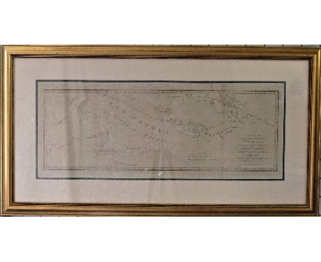
Russia and North Pacific: Ortelius (Abraham), TARTARIAE SIVE MAGNI CHAMI REGNI typus, a circa 1573 engraved map of Russia & North Pacific, hand coloured, image size 13¾in x 18½in (35cm x 47cm), two tiny holes along central fold, minor foxing, recent pencil writing along lower right edge, glazed and framed; certificate of authenticity attached to back.. Note: this was the earliest printed map to focus on the North Pacific, showing the Kingdom of the Great Khan in Asia, including Russia, China, and Japan, with part of North-western America naming California, decorative strap-work title cartouche, and with sailing ships and sea monster
We found 109182 price guide item(s) matching your search
There are 109182 lots that match your search criteria. Subscribe now to get instant access to the full price guide service.
Click here to subscribe- List
- Grid
-
109182 item(s)/page
World Map: Jansson (Joannes), Orbis Terrarum Veteribus Cogniti Typus Geographicus, a mid 17thC engraved map of the ancient world showing Europe, Asia, and Africa, extending south to Madagascar, hand coloured dated by hand in faint ink 1666, image size 15¾in x 20in (40cm x 51cm), foxing, rip along bottom left hand corner and painted in, glazed and framed, together with a small 19thC world map (2)
The Americas: Blaeu (Guiljelmus), AMERICAE nova Tabula. Auct: Guiljelmo Blaeuw., a mid 17thC engraved map of the New World (the Americas) across the top are nine town plans including Havana, St. Domingo, Cartegena, Mexico City, Cusco, Potosi, I. la Mocha in Chile, Rio de Janeiro and Olinda in Brazil, panels down each side show portraits of the native inhabitants taken from early explorers' descriptions, the surrounding oceans with sailing ships and sea monsters, Latin text verso, hand coloured, image size 16in x 21½in (40.5cm x 54.5cm), slight crease along central fold otherwise condition good, glazed and framed.
A Chart of Captn. Carteret`s Discoveries at New Britain, with Part of Captn. Cook`s Passage Thro Endeavour Streights, & of Captn. Dampier`s Tract & Discoveries in 1699, & 1700, at New Guinea & New Britain, a late 18thC sea chart of Papua New Guinea engraved by W. Whitchurch, Pleasant Row, Islington, image size 8½in x 24¾in (21.5cm x 63cm), three fold lines, slightly puckered, and yellowed, glazed and framed, together with a 'MAP of the Country which was the scene of Operations of the NORTHERN ARMY including the WILDERNESS THROUGH which Genl. Arnold marched to attack QUEBEC', engraved by J. Yeager, and a map of 'The WEST INDIES from the best AUTHORITIES', (3)
France: Munster, Sebastian, Das Gantzte Frankreich/so vorzeiten Narbonensis, Lugdunensis, Belgica und Celtica ist genennt worden; a late 16thC/early engraved 17thC Map of France, monochrome, image size 12½in x 14¼in (32cm x 36cm), worm holes, ripped top left and lower central fold, spots, glazed and framed, together with an antique monochrome map 'Antient Spain' (2)
Cornwall: Morden (Robert), CORNWALL by Robert Morden, a late 17thC engraved Map, hand coloured, image size 14in x 16½in (35.5cm x 42cm), paper puckered, together with a 19thC map of The Environs of Plymouth and Devonport, and a 'Survey of the Road between Bristol and Exeter, Bristol to Worcester, Bristol to Weymouth', all glazed and framed (3)
A quantity of Map and Map Collecting reference Books, including Shirley; 'The Mapping of the World', New Holland, 1993, Humphreys; 'Old Decorative Maps and Charts', Halton & Truscott Smith, 1926, limited edn. no 366 / 1500, Cortazzi; 'Isles of Gold Antique Maps of Japan', 1983, 'Steilers Hand-Atlas', folio, 1914 edn etc., (a lot)
Four maps by E Bowen, monochrome: France, Italy and 'A Map of the Extent of Alexanders Conquests' , together with another similar: Persia Sive Shahistan, L'India Orientale, and 'A Map of Europe from the best Authorities, Spede reprints etc.; all loose, and a Carte de L'Empire du Japon by M Bellin, overmounted (a lot)
Bus and Coaching Interest; A Southern National Route Map, of North Devon and Cornwall, circa 1960's, framed and glazed, 31in (78cm) wide, together with a Western National and Southern National card route map, also for North Devon and Cornwall, in poor condition, and two route map posters for 'Somerset & East Devon' and 'North Devon & North Corwall' (4) Provenance: From the John Shapland Collection; Bus Inspector and life-long bus and coach collector and enthusiast. Member of The WestCountry Historic Omnibus & Transport Trust (WHOTT)
Bus and Coaching Interest; A Royal Blue Express Services enamel Booking Office Sign, in blue and yellow enamel, top half with a map of Southern England, with Queen Street, Exeter address, circa 1960's, 30in (76cm) high, overall fair condition, with some minor chipping and rust. Provenance: From the John Shapland Collection; Bus Inspector and life-long bus and coach collector and enthusiast. Member of The WestCountry Historic Omnibus & Transport Trust (WHOTT)
Bus and Coaching Interest; An Associated Motorways 'Day and Night Express Coach Services' enamel Booking Sign, with yellow pictorial route map, the coach number plate dated 1953, on original painted wooden frame, enamel sign 30in (76cm) overall height 36in (91.5cm), some holes and losses. Provenance: From the John Shapland Collection; Bus Inspector and life-long bus and coach collector and enthusiast. Member of The WestCountry Historic Omnibus & Transport Trust (WHOTT)
Bus and Coaching Interest; A Royal Blue Express Services enamel Booking Office Sign, in blue and yellow enamel, top half with a map of Southern England, with Queen Street, Exeter address, circa 1960's, 30in (76cm) high, some chipping and rust, in original blue painted wooden frame, one leg damaged. Provenance: From the John Shapland Collection; Bus Inspector and life-long bus and coach collector and enthusiast. Member of The WestCountry Historic Omnibus & Transport Trust (WHOTT)
Bus and Coaching Interest; A vintage red and white painted free-standing Poster Board, one side with Associated Motorways 'Route Map' booking poster stuck, the other with a destination advertising poster for Weston-Super-Mare. overall height 37½in ( 95.5cm) Provenance: From the John Shapland Collection; Bus Inspector and life-long bus and coach collector and enthusiast. Member of The WestCountry Historic Omnibus & Transport Trust (WHOTT)
The "District Railway" Map of London, 5th edition, c1893, a large-scale, full-colour map, 42in x 26in (107cm x 66cm), linen-backed and folded, shows the un-named Regent's Canal, City & Docks Railway and the City Lines route to Barbican as proposed and Barnsbury station on the North London Railway, also shows London's first tube line, the C&SLR, from City to Stockwell plus the planned extension to Clapham, worn condition, lacks front cover.
A Small Quantity of Militaria, comprising a Second World War Mickey Mouse respirator for a small child, in original cardboard box; a pair of gas mask spectacles with steel frames in original steel case; an embroidered cloth 1st SAS shoulder title, cap insignia and brass badge; silk escape map of Holland, Belgium, France, Germany and Switzerland; an escape and evasion compass; Home Guard and ARP lapel badges; a woolwork pin cushion worked with the allied flags; two lead bullets
An Album of Approximately Fifty First World War Period Postcards, mainly colour printed, some real photographic, including humour, beauties and regimental portrait groups; a Miniature ''Little Keepsakes'' Book by S. Robinson, 1904, the inner cover with pencil inscription 1915; Ephemera, including Northern Command Tattoo programme and souvenirs, Fragments From France, training pamphlets, a 1932 War Office folding map of the Isle of Man, a Soldier's Record and Pay Book to 22393475 Francis Reginald De-Caux, Home Guard citation etc
A Second World War BEM Group of Five Medals, awarded to 7927638 Sergeant John Mason, Royal Tank Regiment, Royal Armoured Corps, comprising British Empire Medal in box of issue, with Buckingham Palace award letter, 1939-45 Star, Africa Star (8th Army clasp missing) and Italy Star, in postal box of issue, together with Mentioned in Despatches Oak Leaf with citation (London Gazette 13th January 1944), Soldier's Service and Pay Book, Release Book, testimonial letters and related ephemera, a pair of slip-on shoulder epaulettes with embroidered 8th Army formation patches, a pair of embroidered No.1 Armoured Replacement Group C.M.F. formation patches, two lanyards, RAC cap badge etc, also a silk escape map Cyrenaica, The Italian Campaign RAC folio book, Egypt souvenir photograph album Footnote:- Sergeant John Mason was mentioned in despatches in recognition of gallant and distinguished services in the Middle East and awarded the British Empire Medal for meritorious services in Italy
An unusual late 18th early 19th century ivory fan, painted with the map of Tendre, 25 cmNote: The Map of Tendre is a French map of an imaginary land called Tendre produced by several hands (including Catherine de Rambouillet) it appeared as an engraving (attributed to François Chauveau) in the first part of Madeleine de Scudéry's 1654-61 novel Clélie. The map represents the path towards love according to the précieuses of the time periodOne of the sticks with small losses, all stick present, silk band split in places, see images
Attributed to John Ogilvy - "The Road from Oxford to Cambridge - The Arms of the College's, etc., in Oxford...", engraving coloured by hand, 18.3 x 12cms (plate size); together with a miniature map of Yorkshire, possibly after William Green, 12 x 8.8cms (image size), in none-matching frames. (2)
[Jean-Baptiste Christyn]: 'Het schouwburg der Nederlanden ... beschryvinge der XVII. Nederlandsche provintien', Antwerp, 1785, 5 vol. -- Description: [Jean-Baptiste Christyn]: 'Het schouwburg der Nederlanden ofte geographische en historische beschryvinge der XVII. Nederlandsche provintien', Antwerp, C.M. Spanoghe, 1785, 5 vol.Ê I: 12mo: Front. (dated 1786)-[2]-310 pp., 31 pl. (incl. the map of the 17 provinces and 27 folding plates). Ê II: 12mo: Front. (dated 1786)-443pp., 38 folding pl.Ê III: 12mo: Front.-372pp., 38 folding pl.Ê IV: 12mo: Front. (dated 1786)-397pp., 20 pl. (of which 19 folding plates).Ê V: 12mo: Front. (dated 1786)-348pp., 29 pl. (of which 27 folding plates).Ê Later half calf, gilt flat spine, leather title label, by F. Schmitz (Maastricht). With ownership entries (ex-libris Lud. (baron?) de Crassier; 2 oct 1895).
RARE GEOLOGICAL MAP of the British Isles, based on the works of the geological survey by J J H Teall, MA. Lld .SC. F.R.S director 2nd edition 1912 SCALE OF TWENTY FIVE STATUE MILES TO ONE INCH/1584000. Engraved at the ordnance survey office, Southampton, price uncoloured one shilling. coloured two shilling. Frame and glazed in original oak frame a good clean impression of this rare coloured map size 35" x 25"
Golden Cockerel Press.- Chair (Somerset de) The Silver Crescent, number 18 of 30 specially-bound copies, signed by the author, from an edition limited to 500, photographic illustrations, map endpaper, original blue crushed morocco by Sangorski & Sutcliffe, spine faded, some occasional light rubbing to extremities, 8vo, 1943.
Jones (David) In Parenthesis, first edition, frontispiece, plate and map by the author, a few pencil annotations to preface and small markings to text, small book-label to rear pastedown, original beige cloth, spine a little browned but a good copy, 1937; The Anathemata, first edition, plates, Evan Gill's copy with his book-label, original cloth, dust-jacket, not price-clipped, spine lightly browned, 1952; The Sleeping Lord, number 143 of 150 copies signed by the author, frontispiece, original cloth, slip-case, 1974 § Jones (Huw Ceiriog) The Library of David Jones (1895-1974): A Catalogue, original cloth, dust-jacket, Aberystwyth, 1995 § Coventry (Francis) The History of Pompey the Little..., one of 400 copies, wood-engraved frontispiece and tail-piece by David Jones, leather book-label of Micheline & Mervyn Parkhouse, original cloth-backed boards, uncut, lower corners slightly bumped, slip-case, Waltham St. Lawrence, Golden Cockerel Press, 1926 § Leslie (Shane) Fleet Street, The New Broadside No.16, 2 colour illustrations by David Jones, c.430 x 190mm., tipped into aperture mount, Poetry Bookshop, [c.1926]; and a bundle of others by or relating to Jones including several prospectuses for his works, v.s. (sm.qty)
-
109182 item(s)/page