
Oates (Frank). Matabele Land and Victoria Falls. A Naturalist's Wanderings in the Interior of South Africa, 2nd edition, Kegan Paul, Trench, and Co., 1889, mounted engraved frontispiece, 6 chromolithographic plates, 13 hand-coloured lithographic plates including 2 after J. G. Keulemans, 1 uncoloured lithographic plate, 2 wood-engraved plates, 4 linen-backed folding maps, light spotting to frontispiece, title-page and folding map, later gift inscription to initial blank, book-label of amateur botanist Alfred Edward Moxon (1862-1930), front inner hinge reinforced, contemporary red half calf, front joint rubbed, 8vo (21.3 x 13.4 cm), together with: Cumming (Roualeyn Gordon). Five Years of a Hunter's Life in the Far Interior of South Africa, 2 volumes, 1st edition, John Murray, 1850, half-titles, wood-engraved frontispieces, additional vignette title-pages, 12 plates, map, spotting to preliminaries, engraved armorial bookplates of William Willoughby Cole, 3rd Earl of Enniskillen (1807-1886), contemporary tan half calf, 8vo (19.4 x 12.2 cm) , Baldwin (William Charles), African Hunting and Adventure from Natal to the Zambesi including Lake Ngami, the Kalahari Desert, etc., from 1852 to 1860, 2nd edition, Richard Bentley, 1863, engraved portrait frontispiece, 6 tinted lithographic plates (plate facing p. 157 nicked in fore margin), 8 wood-engraved plates, double-page map, engraved bookplate of Walter Wren (1833-1898), contemporary red half morocco, 8vo (21.6 x 13 cm), and Baden-Powell (Robert S. S.), The Matabele Campaign 1896, 2nd edition, Methuen and Co., 1897, prize inscription to initial blank, contemporary tan calf gilt, 8vo (19.6 x 12. 5 cm) (Qty: 5)Czech (Africa) pp. 71 (Cumming, second edition), 16-17 (Baldwin, first edition: 'One of the best books describing early African big game hunting'); Mendelssohn II p. 112 (Oates, first edition, 1881), I pp. 398-9 (Cumming, second edition), I pp. 73-4 (Baldwin), I p. 64 (Baden-Powell); Wood p. 497 (Oates: 'the present edition [contains] much additional matter, especially on birds by Bowdler Sharpe'). This first edition of Cumming's work is uncommon: the second edition, published later the same year, is more usually encountered and is the one referred to by Czech and Mendelssohn. Provenance: Library of Colin and Joan Deacon.
We found 109198 price guide item(s) matching your search
There are 109198 lots that match your search criteria. Subscribe now to get instant access to the full price guide service.
Click here to subscribe- List
- Grid
-
109198 item(s)/page

Back (George). Narrative of the Arctic Land Expedition to the mouth of the Great Fish River, and along the shores of the Arctic Ocean, in the years 1833, 1834, and 1835, 1st edition, 1836, folding engraved map, 16 engraved or lithographed plates, some spotting, light offsetting and toning, dedication leaf unopened, modern green morocco-backed boards, spine a little faded, 8vo (Qty: 1)Sabin 2613. Provenance: Library of Colin and Joan Deacon.

Oliphant (Laurence). The Trans-Caucasian Campaign of the Turkish Army under Omer Pasha, 1st edition, Edinburgh: William Blackwood and Sons, 1856, 4 tinted lithographic plates including frontispiece, folding plan, folding map to rear, 2 pp. publisher's advertisements to front and 16 pp. to rear, spotting to frontispiece, a few spots to other plates, short closed tear to folding map stub, inner hinges repaired, original green pictorial cloth gilt, spine sunned, small chip to headcap, faint discolouration to sides, tips bumped, 8vo (Qty: 1)Not in Abbey. Provenance: Library of Colin and Joan Deacon.

Park (Mungo). Travels in the Interior Districts of Africa: Performed under the Direction and Patronage of the African Association, in the years 1795, 1796 and 1797, 1st edition, 1799, half-title, engraved portrait frontispiece, 3 folding maps, 5 engraved plates, 2 leaves of music, front endpapers and a few leaves at end with small marginal insect damage, some offsetting and toning, contemporary speckled calf gilt, rebacked, a little rubbed, 4to, together with: ibid., The Journal of a Mission to the Interior of Africa, in the Year 1805, 1st edition, for John Murray by W. Bulmer, 1815, engraved folding map hand-coloured in outline, contemporary streaked calf, rebacked, 4to (Qty: 2)Provenance: Library of Colin and Joan Deacon.

Paterson (William). A Narrative of Four Journeys into the Country of the Hottentots, and Caffraria, 1st edition, for J. Johnson, 1789, 17 engraved plates, folding map, toning, plates offset and marginally damp-stained, a few spotted in image, folding map spotted, ink-stamps of Inner Temple Library to title-page, text, and versos of map and a few plates, bookplate, 19th-century red half morocco, rubbed and marked, 4to (29.2 x 22.8 cm) (Qty: 1)Cox I p. 390; ESTC T89158; Mendelssohn II p. 143. 'Although the principal feature of the work is a description of the botanical specimens ... there are many interesting notes respecting the natives, with a few remarks on the Dutch colonists' (Mendelssohn). Paterson was later appointed governor of New South Wales but 'historians have rightly judged him more important as a natural scientist than as an administrator' (ODNB). A second edition of his work appeared the following year. Provenance: Inner Temple Library (deaccession stamp to title-page verso); Library of Colin and Joan Deacon.

Peary (Robert E.) Northward over the "Great Ice". A Narrative of Life and Work along the shores and upon the interior ice-cap of Northern Greenland in the years 1886 and 1891-1897, 2 volumes, 1st English edition, 1898, portrait frontispieces (one with small repaired tear), maps and illustrations, presentation inscription, top edge gilt, original cloth gilt and silver, a few light marks, 8vo, together with The North Pole, 1st English edition, 1910, folding map, half-tone illustrations, a little light spotting, presentation inscription, original cloth gilt contained in original box (rubbed with a few stains), 4to (Qty: 2)Provenance: Library of Colin and Joan Deacon.
Riley (James). Loss of the American Brig Commerce, wrecked on the Western Coast of Africa, in the month of August, 1815. With an account of Tombuctoo, and of the hitherto undiscovered great city of Wassanah, 1st edition, John Murray, 1817, folding engraved map, some light spotting, previous owner signature and bookplate of Henry Parker, contemporary half calf, rebacked with original spine relaid, a little rubbed, 4to, together with Paddock (Judah). A Narrative of the Shipwreck of the Oswego, on the Coast of South Barbary, and of the sufferings of the master and the crew while in bondage among the Arabs; interspersed with numerous remarks upon the country and its inhabitants and the peculiar perils of that coast, 1st English edition, 1818, library stamp to title verso and final leaf, small repaired tear to title, some spotting front and rear, contemporary calf, rebacked, a little rubbed, 4to (Qty: 2)Provenance: Library of Colin and Joan Deacon.
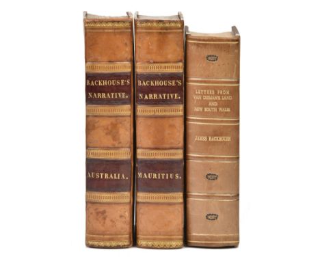
Backhouse (James). A Narrative of a Visit to the Australian Colonies, 1st edition, Hamilton, Adams, and Co., 1843, 14 etched plates (1 folding), 3 folding maps, wood-engravings in the text, plates spotted, maps with linen tape-supports verso at stubs, first map with short closed tear, ink-stamp ('Courtois-Viçose') to initial blank, contemporary tan half calf, rebacked with original spine laid down, 8vo (21.5 x 13 cm), together with: ibid., A Narrative of a Visit to the Mauritius and South Africa, 1st edition, Hamilton, Adams, and Co., 1844, 16 etched plates, 2 folding maps, variable spotting and marginal tide-mark to plates, maps slightly browned and offset, closed tear in text-leaf Y5, contemporary tan half calf uniform with the preceding item, front joint cracked at foot, 8vo (21.5 x 13 cm), and ibid., Extracts from the letters of James Backhouse, now engaged in a Religious Visit to Van Dieman's Land, and New South Wales [ ... Australia ... Mauritius ... South Africa], 10 parts in 1 volume, 3rd edition of part 1, 1st editions of parts 2-10, Harvey and Darton, 1837-41, variable light spotting and browning, repair to part 5 leaf C1, 20th-century quarter calf, 8vo (19.6 x 12 cm) (Qty: 3)Ferguson 3558 (Australian Colonies), 2434, 2226, 2436, 2437, 2703 (Extracts, parts 1-5); Mendelssohn I pp. 61-2 (Extracts, parts 7-10), p. 62 (Mauritius). Provenance: Library of Colin and Joan Deacon.
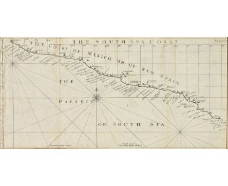
Rogers (Woodes). A Cruising Voyage round the World: First to the South-Sea, thence to the East-Indies, and homewards by the Cape of Good Hope. Begun in 1708, and finish'd in 1711. Containing ... an Account of Alexander Selkirk's living alone Four Years and Four Months in an Island ... 2nd edition ('corrected'), for Andrew Bell and Bernard Lintot, 1718, 4 folding maps by John Senex (of 5: lacking world map by Herman Moll; a fragment of the western hemisphere is laid in), loss to title-page (for both the world map and titlepage a photocopy has been loosely inserted), contemporary ownership inscription 'E Lib. Willi. Stallard, E Hospitio Lyonsis 1719' to front pastedown, later ownership inscriptions to title-page and dedication, contemporary panelled calf, restored, 8vo (19.3 x 12 cm), together with: [ Chetwood, W illiam Rufus], The Voyages and Adventures of Capt. Robert Boyle, who was taken into Slavery, and the Manner of his making his Escape in Company with Mrs. Villars, an English Lady ... To which is added, the Voyage and Shipwreck of Richard Castelamn, Gent., With a Description of Pensylvania and Philadelphia, printed for J. Ford, and sold by S. Gamidge, 1772, M8 repaired and chipped with loss of pagination, contemporary sheep, rebacked, 8vo (18 x 11 cm) (Qty: 2)Sabin 72754 (Rogers), 12553 (Chetwood, but not citing this edition). The maps in Rogers's work depict part of the coastlines of Mexico, Peru, Chile and Ecuador. ESTC traces two copies only for this edition of Chetwood's work, which was first published in 1726. Boyle's narrative is considered fictitious but Sabin remarks that Castelman's 'bears the marks of authenticity'. Provenance: Library of Colin and Joan Deacon.

Russell (William Howard). My Diary in India, in the Year 1858-9, 2 volumes, 1st edition, Routledge, Warne, and Routledge, 1860, folding map, 12 tinted lithographic plates, half-title discarded, spotting and toning, contemporary half calf, 8vo (18.7 x 11.8 cm), together with: Campbell (Walter), My Indian Journal, 1st edition, Edinburgh & Douglas, 1864, half-title, vignette title-page, 7 lithographic plates mainly by J. Wolf, plates slightly spotted, contemporary half calf, gilt spine, wear to fore edges of boards, 8vo (20.8 x 13.4 cm), and Sale (Florentia), A Journal of the Disaster in Affghanistan, 1841-2, 1st edition, John Murray, 1843, folding plan (short closed tear), contemporary half calf, 8vo (18.9 x 11.4 cm) (Qty: 4)Abbey Travel 491 (Russell). Provenance: Library of Colin and Joan Deacon.
Salamé (Abraham). A Narrative of the Expedition to Algiers in the Year 1817, under the Command of Admiral Lord Viscount Exmouth, 1st edition, John Murray, 1819, engraved portrait frontispiece, 3 engraved folding plates (1 hand-coloured), intermittent light spotting and browning, engraved bookplate of the viscounts Exmouth and ownership inscription of a descendant of Edward Pellew, 1st Viscount Pellew ('Fleetwood H. Pellew, May 94') to front pastedown, contemporary diced russia gilt, joints and corners restored, 8vo (21 x 12.6 cm), together with: Lempriere (William), A Tour from Gibraltar to Tangier, Sallee, Mogodore, Santa Cruz, Tarudant; and thence over Mount Atlas, to Morocco, including a Particular Account of the Royal Harem, 1st edition, for the author, 1791, engraved folding map of Morocco, a few quires spotted, modern half calf to style, 8vo (20.8 x 12.7 cm) , and [Corbett, Thomas], An Account of the Expedition of the British Fleet to Sicily, in the Years 1718, 1719 and 1720 under the Command of Sir George Byng (Aftewards Viscount Torrington), 1st edition, J. and R. Tonson, 1739, folding table, later ownership inscription of a descendant 'Col. Cranmer-Byng, Quendon, Essex') to front pastedown, inner hinges reinforced, contemporary sprinkled calf, 8vo (19.2 x 11 cm) (Qty: 3)Cox I p. 391 (Lempriere). Provenance: Library of Colin and Joan Deacon.

Scott (Captain Robert Falcon). The Voyage of the "Discovery", 2 volumes, 1st edition, 2nd impression, 1905, photogravure frontispieces, titles printed in red and black, folding map contained in rear pockets, maps and illustrations, light spotting, top edge gilt, original blue cloth gilt, spine ends rubbed with small splits, covers slightly bowed, 8vo, together with Scott's Last Expedition, 2 volumes, 2nd edition, 1913, maps and illustrations, a few folding and sepia and colour, some light spotting, top edge gilt, original blue cloth, spine ends a little rubbed, 8vo (Qty: 4)Provenance: Library of Colin and Joan Deacon.

Smyth (William Henry). Memoir Descriptive of the Resources, Inhabitants, and Hydrography, of Sicily and its Islands, interspersed with antiquarian and other notices, 1st edition, 1824, half title , folding engraved map, 16 uncoloured aquatint plates on 13 sheets, some offsetting and spotting, a few small marginal water stains, modern half calf gilt, 4to (Qty: 1)Abbey Travel 263. Provenance: Library of Colin and Joan Deacon.
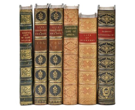
Smyth (William Henry). The Life and Services of Captain Philip Beaver, late of His Majesty's Ship Nisus, 1st edition, John Murray, 1829, together with: Barrow (John). The Life of George Lord Anson, 1st edition, John Murray, 1839, engraved frontispiece (spotted), ibid., An Autobiographical Memoir, 1st edition, John Murray, 1847, engraved portrait frontispiece, ibid., The Life and Correspondence of Admiral Sir William Sidney Smith, 2 volumes, 1st edition, Richard Bentley, 1848, 6 engraved plates including frontispieces, Scoresby-Jackson (R. E.), The Life of William Scoresby, 1st edition, T. Neson and Sons, 1861, engraved frontispiece, additional vignette title-page (slightly spotted), folding map, 5 colour plates, all in contemporary full calf, richly gilt spines, 8vo (Qty: 6)Provenance: Library of Colin and Joan Deacon.

Tuckey (James Kingston). Narrative of an Expedition to Explore the River Zaire, usually called the Congo, in South Africa, in 1816, 1st edition, 1818, half-title, folding engraved map, 13 engraved plates, including one hand-coloured, plates with some toning and spotting, light offsetting, hinges reinforced, contemporary straight-grained morocco gilt, rebacked with original spine relaid, 4to (Qty: 1)Provenance: Library of Colin and Joan Deacon.
Weld (Isaac). Travels through the States of North America, and the Provinces of Upper and Lower Canada, during the years 1795, 1796, and 1797, 1st edition, 1799, folding engraved map with outline colour, four engraved maps and plans, 10 engraved plates only (plate of Mount Vernon supplied in loose facsimile), publisher's catalogue at end, some light offsetting and spotting, Penzance Library stamp to title and label at front, bookplate, contemporary calf gilt, rebacked and covers relaid, 4to, together with [Gleig, George Robert]. A Narrative of the Campaigns of the British Army at Washington and New Orleans, under Generals Ross, Pakenham, and Lambert, in the years 1814 and 1815; with some account of the countries visited, 2nd edition, 1826, a little minor spotting, bookplate of Henry Dalrymple White, contemporary half calf gilt, 8vo, plus Hunter (John D.) Memoirs of a Captivity among the Indians of North America, new edition, 1823, lithograph portrait frontispiece, some light spotting, contemporary half calf, rebacked with original spine relaid, 8vo, with three others: Henry Murray's Lands of the Slave and Free, 2 volumes, 1855, John Sherburne's The Life of Paul Jones from Original Documents, 1825 and George Catlin's Last Rambles amongst the Indians of the Rocky Mountains and the Andes, 1868 (Qty: 7)Provenance: Library of Colin and Joan Deacon.


English Delineated in two volumes, 2 vol., engraved titles and plates, contemporary fine straight grained Morocco, ruled and tooled in gilt, spine gilt, 1804; Bosworth (J, Rev). A Dictionary of the Anglo Saxon Language, 1838; .- Eboracum; or, The History and Antiquities of The City of York ... 2 vol, folding engraved map and plates, non-uniform, contemporary calf and sheep, boards detached, York, 1788; and six others, antiquarian, heavily damaged, worn or defective.


![6 vols Household Reference Library and / Meiddson family [Heusel] Sebastian vol II and Sketch map economic History (?)](https://cdn.globalauctionplatform.com/baa78b0a-f085-476d-b124-aa470117a084/d73c5d23-ef50-4035-91b2-aa49010fb7a4/468x382.jpg)
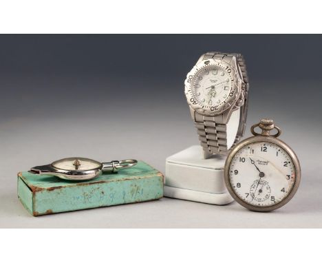
ACCURIST ALARM QUARTZ WRISTWATCH with circular white dial with luminous batons, date aperture, alarm set hand, centre seconds hand, stainless steel case water resistant to 100 metres, having revolving besel, integral stainless steel strap; INGERSOLL 'RELAINCE' AMERICAN METAL CASED POCKET WATCH and a COMBINED MAP MEASURER AND MAGNETIC COMPASS, boxed


J Bye, "Commencement of the Roads to the Lakes of Lancaster, Westmoreland & Cumberland, as far as Hinckley & Leicester", hand coloured road map, 30.5cm x 25.5cm visible size, The Road from London to Derby, hand coloured road map, 16 x 21cm visible size, The Road from Hereford to Leicester, hand coloured road map, 16 x 21.5cm visible size, and Southam-Coventry-Nuneaton-Ashby de la Zouch-Derby road map, hand coloured, 18.5 x 12.8cm visible size. (4)


C & I Greenwood, a Map of the County of Leicester, hand coloured county map, 58 x 70.5cm, J & C Walker, Leicester, hand coloured town and borough map of Leicester, 21 x 24.7cm visible size, Eman. Bowen, The Counties of Leicester & Rutland, hand coloured map of Leicestershire and Rutland, 18 x 19.5cm visible size, and W H Toms, A Map of Leicestershire, North from London, hand coloured county map, 15.5 x 16.3cm visible size. (4)


A map by F. DE WIT: Archiepiscopatus et Electoratus Trevirensis . . . 49cm x 58cm within mount, hand-coloured, engraved pictorial cartouche title, (? ca. 1760); F. DE WIT: Iutiae . . . Dioceses Alburgensis, Wilburgensis (etc.), hand-coloured, 59cm x 48cm within mount, engraved pictorial cartouche title, (? ca. 1760), both framed and glazed. (2)


A map by Matthieu SEUTTER: La Plus Grande Parti de la Manche, qu'i contient les Cotes D'Angleterre et celles de France . . . 51cm x 59cm, hand-coloured, elaborate pictorial title cartouche, part of Normandy inset, includes numerous named sands, especially in Thames Estuary, ca. 1740, framed and glazed.

A map by Nicolas VISSCHER: Comitatus Bergundiae tam in Praecipuas ejus Praefecturas . . . 58cm x 47cm within mount, hand-coloured, pictorial cartouche title, and dedication to George III, with royal arms (? ca. 1780); Nicolas VISSCHER: Palatinatus Ad Rhenum . . . 46cm x 57cm within mount, pictorial cartouche title, pictorial engraved key, (? ca. 1780), both framed and glazed. (2)


A map by (Christopher SAXTON / William KIP): Englalond Anglia Anglosaxonum Heptarchia. 31cm x 38cm, hand-coloured, decorated cartouche title, ships and monsters at sea, Irish coast in outline, decorated compass rose, engraved by William Hole, (? 1637). * from Camden's Britannia, framed and glazed.


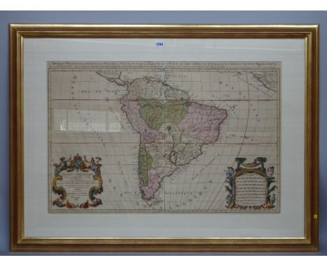
A map by Alexis - Hubert JAILLOT: Amerique Meridionale . . . , 57cm x 88cm within mount, hand-coloured, pictorial cartouche and detailed headline titles, pictorially decorated scale bars, i.e. South America, (Paris, ? ca. 1680s), based on an earlier map by Nicolas Sanson, framed and glazed.


-
109198 item(s)/page