We found 109198 price guide item(s) matching your search
There are 109198 lots that match your search criteria. Subscribe now to get instant access to the full price guide service.
Click here to subscribe- List
- Grid
-
109198 item(s)/page


Lot 685
John Speed (1552-1629). 'A NEW AND ACCURAT MAP OF THE WORLD Drawne according to ye truest Descriptions latest Discoveries & best observations ty have beene made by English or Strangers 1626', a hand-coloured twin-hemisphere engraved map, with astrological and astronomical diagrams, with allegorical figures representing the four elements, with portraits of famous explorers, inscribed 'Are to be sold Pops-Head Alle by Geor. Humble', California represented as an island, with English text to verso, 39 x 51cm, unframed.

Lot 105
AMENDED A rare George III map sampler of England and Wales by Ann Mulliner, depicting the counties of England and regions of Wales with numbered and lettered keys, worked with various designs on a gauze ground, inscribed to the lower edge 'ENGLISH CHANALL' and signed and dated 'ANN MULLINER 1775', 46.5 x 38cm, in a glazed giltwood frame.Provenance: 'A Lifetime of Collecting'-The property of a gentleman.


Lot 48
Montgomery Martin (Robert, editor). Tallis's Illustrated Atlas, and Modern History of the World..., John Tallis and Company, 1851, additional decorative title page, engraved frontispiece of the Great Exhibition, two 'comparison plates', 81 engraved maps (complete), with contemporary outline colouring, occasional spotting largely confined to text, last map (Jamaica) with some staining, all edges gilt, contemporary half morocco gilt, worn and rubbed, folio (Qty: 1)NOTESThis copy in very good condition without the central fold to each map.
Lot 28
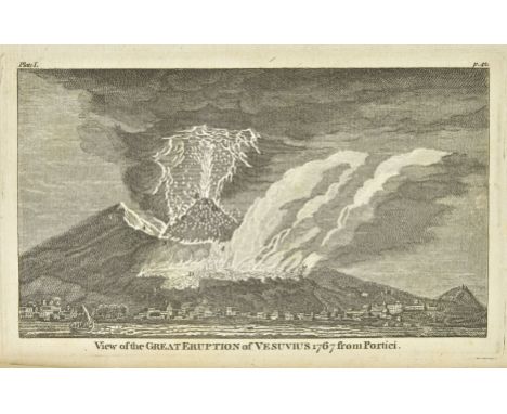
Hamilton (Sir William). Observations on Mount Vesuvius, Mount Etna, and other Volcanos: In a series of letters, addressed to the Royal Society... To which are added, explanatory notes by the author hitherto unpublished, new edition, 1774, five engraved plates, folding engraved map, small Birkbeck College Library stamps, label to rear wrapper, a little light offsetting and soiling, later wrapper, spine faded with typescript label, 8vo (Qty: 1)NOTESFirst published in 1772.
Lot 77
Cary (John). Cary's Traveller's Companion, or, A Delineation of the Turnpike Roads of England and Wales; shewing the immediate route to every market and borough town throughout the kingdom, laid down from the best authorities, on a new set of county maps. To which is added, an alphabetical list of all the market towns, printed for G. & J. Cary, Engravers, 1822, engraved title, contents and advertisement leaf, and 42 single-page engraved county maps, each hand-coloured in outline, general map of England and Wales not present, bound with Cary's New Itinerary: or, an accurate delineation of the great roads, both direct and cross, throughout England and Wales; with many of the principal roads in Scotland. From an actual admeasurement by John Cary; made by command of His Majesty's Postmaster General for official purposes under the direction and inspection of Thomas Hasker Esqr., 9th edition, with improvements, G. & J. Cary, August 1821, engraved title and dedication leaf, printed index of roads, coach routes, list of provincial stagecoaches, and seven folding engraved maps, all but one with hand-colouring in outline, one map torn along fold, without loss, modern quarter black morocco gilt, spine lightly faded, thick vo (Qty: 1)NOTESChubb CCLXXXIV.
![London. Braun (Georg & Frans Hogenberg). Londinum Feracissimi Angliae Regni Metropolis, [1574 or later], engraved map of](https://cdn.globalauctionplatform.com/2032d0fc-fc45-4baa-96fd-aacd0111a502/ec4e21e8-27e6-4d88-847e-aace012e0a86/468x382.jpg)
Lot 129
London. Braun (Georg & Frans Hogenberg). Londinum Feracissimi Angliae Regni Metropolis, [1574 or later], engraved map of London, with contemporary hand colouring, heavily oxidised, slight staining, some cracking and splitting to image causing slight loss, occasional marginal repaired closed tears, 335 x 485 mm, German text on verso (Qty: 1)NOTESJames Howgego, Printed Maps of London, 2 (state 2).

Lot 119
British Isles. Homann (Johann Baptiste), Magnae Britanniae pars Meridionalis in qua Regnum Angliae tam in septem antiqua Anglo-Saxonum Regna..., Nuremberg, circa 1715, engraved map with bright contemporary hand colouring, large uncoloured cartouche, central fold strengthened on verso causing some discolouration to central fold, 575 x 490 mm, together with Elwe (Jan Hubert). Les Isles Britanniques qui contiennent les Royaumes d'Angleterre, Ecosse et Irlande..., Amsterdam, 1792, engraved map with contemporary hand colouring, inset map of the Shetland and Orkney Islands, some overall dust soiling, 475 x 595 mm, with Jaillot (Alexis Hubert). Les Isles Britanniques qui contiennent les Royaumes d'Angleterre, Ecosse et Irlande...., circa 1709, engraved map with contemporary outline colouring, inset map of the Faroe, Shetland and Orkney Islands, slight dust soiling, 460 x 650 mm, with another four similar maps of the British Isles with examples by Sanson, Cary, Tirion and de Fer, various sizes and condition (Qty: 7)
Lot 343
Trollope (Anthony). Orley Farm, 2 volumes, 1st edition, Chapman and Hall, 1862, half-titles, 39 wood-engraved plates after John Everett Millais (toned and slightly spotted), contemporary ownership inscriptions, contemporary dark red half calf by W. M. Pritchard of Brierley Hill, rubbed, 8vo, together with: Hardy (Thomas), Jude the Obscure, 1st edition, Osgood, McIlvaine and Co., 1896, etched frontispiece, map, original cloth, nick to headcap, lower outer corners bumped, 8vo, and Tooke (John Horne), Epea Pteroenta [Greek characters], or the Diversions of Purley. A NEw Edition, revised and corrrected by Richard Taylor, 2 volumes, for Thomas Tegg, 1829, toning, occasional spotting, contemporary ownership inscriptions to initial blanks, bookplates of Desmond Morris, edges untrimmed, modern tan quarter calf, 8vo (Qty: 5)
Lot 320
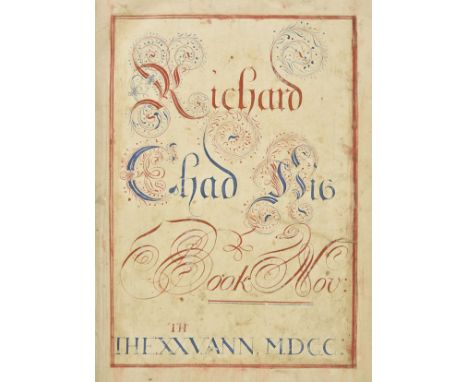
Fontaine (Nicolas, Sieur de Royaumont). The History of the Old and New Testament..., 2nd edition Corrected and Enlarged, printed for R. Blome [etc.], 1701, 240 engraved plates including frontispieces, nearly all after G. Freeman by Kip and others, many printed back-to-back, 5 double-page maps, most plates and maps (and some text leaves) with marginal tears and old repairs, a few with long tears (and old repairs), one map (Jerusalem) close-trimmed at foot, affecting lower vignettes, some generally light toning, spotting or soiling, preliminary blank with mounted large (30.5 x 21.5 cm) calligraphic ownership inscription, executed in red and blue inks, 'Richard Chad His Book Nov: The XXVth Ann MDCC', somewhat soiled, with old repaired tear to right hand side, modern quarter calf gilt, large folio, together with Rushworth (John) , The Tryal of Thomas Earl of Strafford..., 1st edition, for John Wright and Richard Chiswell, 1680, engraved portrait frontispiece, lacking front and rear blanks, some spotting and minor marks, modern quarter calf gilt, folio, plus Sarpi (Paolo) , The Historie of the Councel of Trent, conteining eight Bookes ... faithfully translated into English by Nathanael Brent, 1st edition in English, 1620, bound with the colophon leaf and the terminal blanks (lacking initial blanks), woodcut head- and tailpieces and decorative initials, occasional early ink manuscript marginalia, some dampstaining to lower outer corners, modern quarter calf gilt, folio, with two others similar (one defective) (Qty: 10)
![Herdman (William Gawin). Pictorial Relics of Ancient Liverpool. Subscriber's Copy, 1st edition, 2nd issue, [Liverpool]: publi](https://cdn.globalauctionplatform.com/2032d0fc-fc45-4baa-96fd-aacd0111a502/f51f8c8b-fecf-42af-9107-aace012df392/468x382.jpg)
Lot 82
Herdman (William Gawin). Pictorial Relics of Ancient Liverpool. Subscriber's Copy, 1st edition, 2nd issue, [Liverpool]: published by the author, 1847, 48 tinted lithographic plates (3 folding), spotting to plate-margins, folding plates and to text-leaves facing plates, lacking lithographic title-page, all edges gilt, contemporary brown morocco, spine relaid, rubbed overall, folio, together with: Lewis (Samuel). A Topographical Dictionary of Scotland .... Supplementary volume [only]: Map of Scotland, S. Lewis and Co., 1849, large folding map divided into 6 sections separately stub-mounted as issued, some separations at intersections of folds, original cloth, 4to, and a folder of approximately 150 Scottish topographical engravings (Qty: 2 books and 1 folder)NOTESAbbey Scenery 202 (Herdman).

Lot 123
Estate Plans. Map of Willersley Estate. The Property of John Freeman Esq. in the County of Hereford, 1802, pen, ink and watercolour estate plan on vellum by D. Pain of Lugwardine, some dust soiling, slight spotting, old folds, 370 x 405 mm, together with Map of Estate in the Parish of Flyford Flavel and Kington in the County of Worcester the property of Mrs. Nancy Eades, Surveyed by R. Ladbury, 1822, pen, ink and watercolour plan on vellum, edged in green silk, old folds, 420 x 360 mm, with Messrs. Knight Frank & Rutley (publishers). Map of the Lythehill Estate Haselmere, 1934, large colour lithographic estate map, old folds, torn with loss to right hand margin but not affecting image, some creasing, 970 x 895 mm (Qty: 3)
![[Bible [English]. [The Holy Bible, conteyning the Old Testament and the New, Imprinted at London by Bonham Norton and John Bi](https://cdn.globalauctionplatform.com/2032d0fc-fc45-4baa-96fd-aacd0111a502/0230c44c-04f6-4785-98ec-aace012e7658/468x382.jpg)
Lot 301
[Bible [English]. [The Holy Bible, conteyning the Old Testament and the New, Imprinted at London by Bonham Norton and John Bill, 1629], lacking preliminary signatures A1-4 including general title, retaining New Testament title with decorative woodcut border (18th & 19th century genealogical entries to verso with show-through), Apocrypha present, few leaves torn with text loss and some old repairs, bound with an incomplete The Booke of Psalmes, collected into English Meeter, by Thomas Sternhold, John Hopkins, and others..., London: Imprinted for the Company of Stationers, 1628, and bound with an incomplete Common Prayer & Psalms at rear, also bound with The Genealogies by John Speed, including double-page woodcut map, dust-soiling, occasional marks and dampstains throughout volume, edges frayed throughout, early 20th century cloth, rubbed, 4to (leaf size 22 x 16 cm) (Qty: 1)NOTESHerbert 425; Darlow & Moule 325; STC 2286.
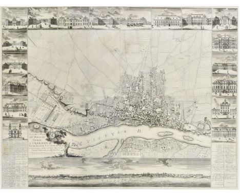
Lot 153
* Warsaw. De Tirregaille (Pierre). Plan de la Ville de Varsovie dedie a S.M. Auguste III Roi de Pologne Electeur de Saxe. & &. levé par ordre de S.E.M. Comte Bielinski Grand Marcchal de la Couronne par M.P. Ricaud de Tirregaille Lieut Colonel et Inginieur au Service du Roi et de la Republique en 1762, large uncoloured engraved city plan, on four conjoined sheets, decorated with eighteen vignettes of the principal buildings within Warsaw, with a key list - in French & Polish - and a panorama of the city viewed from the Vistula River, occasional marginal repaired closed tears, 1025 x 1340 mm, mounted, framed and glazed (Qty: 1)NOTESA very good example of this scarce and important plan of warsaw by Pierre de Tirregaille. Pierre Ricaud de Tirregaille (1725-1770) was a French architect and engineer. Tirregaille came to Poland in 1752, where he worked as a civil architect, surveyor and as an army engineer and captain of an infantry regiment, eventually attaining the rank of lieutenant colonel in the Polish armed forces in 1762. In 1758 and 1759, Tirregaille worked for the "Komisja Brukowa" or Cobblestone Commission. Created in 1685, the Cobblestone Commission was tasked with paving the streets of Warsaw and creating a modern sewer system. The Commission remained largely inactive until 1740, when it was headed by Crown Marshal Franciszek Bielinski. Under his leadership, over the next 20 years, the commission managed to pave 222 streets, a large majority of streets of the contemporary Polish capital. In 1757, Bielinski, with his own funds, created a the village of Bielino, which would become the modern city centre of Warsaw. In 1762, with his work nearly completed, Bielinski commissioned Tirregaille to prepare a detailed plan of the city of Warsaw, which resulted in the creation of the first map of Warsaw based upon a scientific survey. The view was embellished with vignettes of important buildings around the city, including, the Primate's Palace, the Symonowicz Palace, the palace of the Bishops of Cracow and the Radziwill Palace. Tirregaille's map is a monument to all of Bielinski's efforts in creating 'modern' Warsaw.
![* Poland. Speed (John), A Newe Mape of Poland, Thomas Bassett & Richard Chiswell, [1676], hand coloured engraved 'carte-a](https://cdn.globalauctionplatform.com/2032d0fc-fc45-4baa-96fd-aacd0111a502/7fde2e8c-5ba6-4a52-8252-aace012e12e6/468x382.jpg)
Lot 150
* Staffordshire. Map of the Township of Tunstall in the Parish of Wolstanton in the County of Stafford, Surveyed by Robert Malabar & Son, Newcastle under Lyme, 1863, uncoloured engraved plan, some creasing and dust soiling, closed repaired tear affecting image, varnished, edged in green silk, 975 x 655 mm, framed and glazed, together with Downes (John, Surveyor and Architect). Plan of Hoolt Town Cotton Mills in the occupation of James Guest Esq., published Pigot & Slater, 1840, uncoloured lithographic plan, some additional pencil annotations, some creasing and dust soiling, 475 x 635 mm, framed and glazed (Qty: 2)
![Saluste Du Bartas (Guillaume de) , Bartas His Devine Weekes & Workes Translated, 1st edition, [London: H. Lownes, 1605],](https://cdn.globalauctionplatform.com/2032d0fc-fc45-4baa-96fd-aacd0111a502/947f6373-73c3-4b94-a30f-aace012e928a/468x382.jpg)
Lot 373
Saluste Du Bartas (Guillaume de) , Bartas His Devine Weekes & Workes Translated, 1st edition, [London: H. Lownes, 1605], A1 blank present with early ownership signature 'Simon Smyth' at head, decorative engraved title incorporating celestial & terestrial globe maps, few woodcut armorials and decorations, occasional light spotting, some fraying mostly to first & last few leaves, sewing restrengthened, disbound 4to, together with Prince (John). Danmonii Orientales Illustres : or, The Worthies of Devon, Exeter: Sam. Farley for Awnsham and John Churchill, Charles Yeo and Philip Bishop, 1701, woodcut armorials to text, armorial bookplate of William Dacres Adams to front pastedown, contemporary panelled calf, boards detached, lacking spine, folio, with (Raleigh, Walter Sir) , The History of the World, 1st edition, London: Walter Burre, 1614, engraved title incorporating world map, Minde of the Front present (both leaves detached & frayed), lacking all maps and without battle plans, contemporary calf, boards detached and lacking spine, worn, folio, and Grose (Francis) , A Treatise on Ancient Armour and Weapons, 1786, and Military Antiquities Respecting a History of the English Army, from the Conquest to the Present Time, 2 volumes, 1786-1788, together three volumes, engraved frontispieces, titles, and numerous plates, some leaves loose & frayed, slight worming to Treatise on Ancient Armour, occasional spotting, contemporary uniform marbled calf, boards detached, lacking spines, 4to (Qty: a carton)

Lot 382
Antiquarian. A collection of mostly 19th century literature & reference, including Stanford's Library Map of England & Wales, 1882, 4 folding maps in original leather slipcase, The Complete Angler, by Izaak Walton, 1901, gilt decorated full calf bound by Spottiswoode & Co., 8vo, 6 vellum documents, some gilt decorated leather, some original cloth, G/VG, 8vo/folio (Qty: 3 shelves)
Lot 54
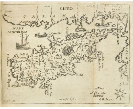
Piacenza ( Franceso ). L'Egeo Redivivo, o' sia chorographia dell' archipelago ... con la breve descrittione ... della Grecia, Morea, o'Peloponnese, di Candia, e Cipri, 1st edition, Modena: Soliani heirs, 1688, additional engraved title page, engraved portrait, 4 engraved maps bound as plates (2 folding, including the map of Cyprus), 59 full-page engraved maps in the text, contents possibly washed, occasional light residual browning, text maps with variable show-through rectos, folding map of the Peloponnese bound upside-down, contemporary vellum, manuscript spine-title, 4to (21.6 x 16.2 cm) (Qty: 1)NOTESBlackmer 1305; Cobham-Jeffery p. 50. First and only edition, rare, especially in this condition with all maps present. Six copies traced in UK libraries; another copy was sold in these rooms on 10 April 2019. 'This work was probably inspired by the Venetian conquests in Greece in the 1680s. It includes a very thorough and systematic description of the Aegean Islands, Crete, [and] Cyprus, and brief descriptions of Roumeli and the Peloponnesus ... The four separate maps are of the Aegean, the Peloponnesus, Crete and Cyprus' (Blackmer).

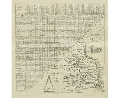
Lot 155
Yorkshire. Bowen (Emanuel). An Accurate Map of the West Riding of York Shire..., An Accurate Map of the North Riding of Yorkshire..., [and] An Accurate Map of the East Riding of Yorkshire..., C & J Bowles and Robt. Sayer, circa 1777, together three engraved maps with contemporary outline colouring, each sectionalised and laid on linen, each with ink library stamps and red crayon number to the upper left corner, each approximately 540 x 720 mm, plus Morden (Robert) , The West Riding of Yorkshire, [and] The East Riding of Yorkshire [1695 or later], together two hand coloured engraved maps, some staining and spotting, each approximately 370 x 430 mm, both framed and glazed (Qty: 5)NOTESBowen's 'Accurate Maps' were originally published in E. Bowen & T. Kitchin's 'Large English Atlas'.

Lot 142
* Poland. Sotzmann (D. F.), Karte des Königl. Preuss. Herzogthums Vor und Hinter. Pommern nach Speciellen Vermessungen entworfen von D. Gilly Königl. Preuss. Geheimen Ober Baurath in Kupfer ausgeführt in Jahre 1789..., Berlin 1789, very large uncoloured engraved map on six conjoined sheets, 1000 x 2110 mm, framed and glazed (Qty: 1)NOTESThis monumental map is regarded as the first scientific survey of Prussia and was produced for the Schulenburg - Schmettau atlas.
Lot 43
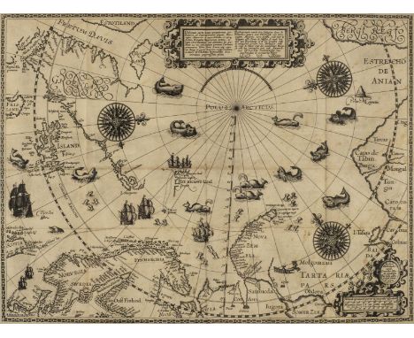
Linschoten (Jan Huyghen van). Navigatio ac itinerarium in orientalem sive Lusitanorum Indiam [part 2: Descriptio totius Guineae tractatus, Congi, Angloae, et Monomotapae]. Collecta omnia ac descripta per eundem Belgicè; nunc vero Latinè reddita, 2 parts in 1 volume, 1st edition in Latin, The Hague: Albert Henricksz, at the expense of the author and Cornelis Nicolaas, to be sold at the shop of Elzevir, 1599, 2 title-pages each with large engraved ship vignette, engraved arms (signature *2 verso), engraved portrait (*4 verso), 32 double-page engraved plates and plans (of 36), of which 3 also folding, and 2 (Goae Indiae Orientalis Metropolis and Angrae Urbis Tercerae) folding and on 2 sheets, opening to 55.5 x 75.5 cm and 48 x 83 cm respectively, 5 folding maps (of 7), moderately browned, title-page dust-soiled, marginal damp-stain to head of gutter from front of volume to quire E, steadily reducing, just touching text in first few pages, never touching engravings, a few old repairs (plate 'Primum urbs Mossambicquae' reinforced along fore edges verso; 'Forum seu praeconium Goae' with 2 old repairs verso to margin and fold; 'Bramenes' with 2 repaired closed tears to top margin; 'Provinciae Pegu' with restoration to left-hand margin; 'Arabes et Abyssini' lower margin strengthened), Goa plan with 1cm split to fold, Barentsz map with a small hole at central intersection and a few faint marks, 19th-century calf, rubbed, some stripping, water-damage to head of front joint, wear to foot of spine, folio (30.6 x 19.8 cm) (Qty: 1)NOTESProvenance: George Becher Blomfield (1801-1885), English clergyman and bibliophile. Adams L735; Borba de Moraes I p. 418; Sabin 41366; cf. Lipperheide 1454-5. Rare first edition in Latin, the second overall, and the first to contain the important Barentsz map of the Arctic regions, 'Deliniatio cartae trium navigationum per Batavos, ad Septentrionalem plagam', populated by imaginary sea-monsters. The plates, which include views, city plans, local costumes and customs, and botanical subjects, are the same as those in the Dutch first edition of 1596 with Latin captions added. 'Linschoten was born in Haarlem, Holland, in 1563. In 1583 he sailed to India with Vicente da Fonseca, archbishop of Goa. He remained there until 1589, the year of his master's death, when he returned to Holland. Later, in 1594, he joined the expedition which, under the command of Nay, Brandt and Barentz, made discoveries in the China Sea. Linschoten died in Holland in 1633' (Borba de Moraes). His wide-ranging account is considered 'the real starting point of Dutch overseas expansion' (Helmers & Jannsen, eds., The Cambridge Companion to the Dutch Golden Age, p. 168). This copy notably retains the two large folding plans of Goa and Angra by Jan van Doetechem after Linschoten, and the two folding views of St Helena. (The list of plates lists one plan of St Helena but the two present are evidently separate engravings.) The other folding plate is 'Forum seu praeconium Goae'. The extant maps are: Delineatio orarum maritimarum, terrae vulgo indigetatae terra do Natal, item Sofalae, Mozambicae, et Melindae ... ad Indiam ... Arnoldus F. à Langren delineavit et sculpsit Exacta et accurata delineatio cum orarum maritimarum tum etiam locorum terrestrium quae in regionibus China, Cauchinchina, Camboja sive Champa, Syao, Malacca, Arracan, et Pegu ... Arnoldus F. à Langren delineavit, Henricus F. ab Langren sculpsit Typus orarum maritarum Guineae, Manicongo, et Angolae ... Arnoldus F. à Langren delineavit, et sculpsit Deliniatio cartae trium navigationum per Batavos, ad Septentrionalem plagam ... Auctore Wilhelmo Bernardo. Cornelius Nicolai excudebat. Baptista à Doetechum sculps. anno 1598 Delineatio omnium orarum totius Australis partis Americae ... Arnoldus Florentius à Langren, author et sculptor This copy lacks the following plates (as named in the Index): 1) Agricola Indus Lascarinus et Balhadera; 2) Indorum casae, villae et vici cira Goam; 3) Scaphae piscatoriae quibus in fluminibus uruntur; 4) Nuces Indicae seu palmae; and the following maps: 1) Generalis orbis tabula; 2) Tabula Rubri maris usque ad Bengalam. Borba de Moares notes that copies rarely contain all the maps as the book was widely used by explorers long after publication.
Lot 95
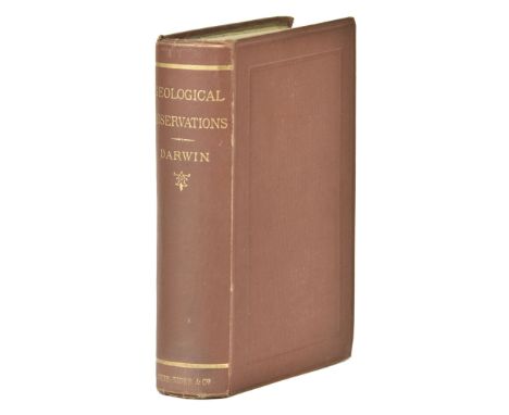
Darwin (Charles). Geological Observations on the Volcanic Islands and Parts of South America visited during the Voyage of H.M.S. 'Beagle', 2nd edition, Smith, Elder, & Co., 1876, half-title with advertisements verso, 2 folding maps, 5 folding plates, light spotting towards front of volume, leaf 2R2 fore edge chipped, 4 cm closed tear to second folding map affecting frame only, plates spotted and with a few partial splits to folds, plate 1 with 6.5 x 5 cm section excised but present (laid in), contemporary bookseller's ticket (John Dale & Co., Bradford) to front pastedown, original dark red cloth, a little wear to spine-ends and tips, 8vo (Qty: 1)NOTESFreeman F276.

Lot 146
* Russia & Poland. Moll (Herman), To His Most Serene and August Majesty Peter Alexovitz Absolute Lord of Russia, &c. this Map of Moscovy, Poland, Little Tartary and ye Black Sea &c. is Most Humbly Dedicated.., J. Bowles, T. Overton, T. Bowles and J. King, circa 1729, large engraved map with contemporary outline colouring on two conjoined sheets, large uncoloured allegorical cartouche, 610 x 985 mm, mounted, framed and glazed (Qty: 1)

Lot 21
Dufour (Adolphe Hippolyte). Grand Atlas Universel Physique, Historique et Politique et Geographie Ancienne et Moderne, Paris, Maison Abel Pilon , circa 1860, title page and contents list with marginal fraying and some worming, forty engraved double page maps, including world map, engraved by Jomard, with contemporary hand colouring, map of the world with some juvenile crayon scribbling, slight dust soiling throughout, preliminaries frayed and torn, contemporary quarter morocco gilt, worn and frayed, folio, together with another 19th century French atlas by Meissas and Michelot, lacking title page and preliminaries, eleven double-page engraved maps only, with contemporary outline colouring, contemporary quarter cloth over marbled boards, 4to (Qty: 2)NOTESSold as a collection of maps, not subject to return.
![Ptolemy (Claudius). La Geografia, gia tradotta di Greco in Italiano da Giero[lamo] Ruscelli: e hora in questa nuova editione](https://cdn.globalauctionplatform.com/2032d0fc-fc45-4baa-96fd-aacd0111a502/e0100ab2-a56d-43f5-93fe-aace012de48f/468x382.jpg)
Lot 55
Ptolemy (Claudius). La Geografia, gia tradotta di Greco in Italiano da Giero[lamo] Ruscelli: e hora in questa nuova editione da Gio[vanni] Malombra ricorretta, e purgata d'infiniti errori, 3 parts in 1 volume, Venice: Giordano Ziletti, 1574-73-73, signatures *-**4 A-H4 (Tavola) A-Z Aa-Xx4, A-Z Aa-Dd2 +2 A-Z Aa-Oo2, alpha-eta4, A-G4 H6, 65 double-page copper-engraved maps, mounted on stubs, woodcut device to each title-page (3 in total), complete with the 3 blanks (H4 of Tavola, eta4, and final leaf, H6), numerous woodcut diagrams and vignettes in the text, including 2 of Ptolemy star-gazing, and a full-page diagram of the classical compass winds, generally light browning, stronger to a few Ptolemaic maps (Europa, 6-9), heavier browning to a few sections of text, occasional spotting, maps clean except for some show-through versos, one marginal worm-track in quires D-E of part 1, contemporary manuscript catch-title to bottom edge of text-block, contemporary limp vellum, yapp edges, slightly marked and dust-soiled, later manuscript title to spine, early inscription to rear cover, housed in a custom blue cloth solander box, 4to (22 x 16.4 cm) (Qty: 1)NOTESAdams P2236; Sabin 66506; Shirley, Britain 110-11, World 110-11. Third edition of Ruscelli's translation, the first corrected by Giovanni Malombra, and containing one additional map, 'Territori di Roma'; Ruscelli's translation first appeared in 1561. Of the 65 maps 27 are Ptolemaic and 38 are modern: the latter include two important world maps, the double-hemispherical 'Orbis Descriptio' and the rectangular 'Carta Marina', both adapted from Gastaldi's Ptolemaic atlas of 1548. Shirley remarks that the 'Orbis Descriptio is elegantly designed and engraved on copper with typical Italian taste and skill. Separate double-hemispherical maps were no innovation but this is the first time that such a representation had been used in an atlas'.

Lot 164
* Fairburn (John, publisher). Starting the Hare, The Death of the Hare, Going to Cover, Death of the Fox, Uncoupling the Hounds, & The Stag at Bay, published 1794, together six mezzotints with contemporary hand colouring, some toning largely confined to margins, 'Going to Cover' with some 'whitening' to upper margin, each approximately 250 x 360 mm, mounted and uniformly framed and glazed (Qty: 6)NOTESFairburn's publication line below each image reads:- 'Map, Chart & Printseller no. 146 Minories , London'.
Lot 131
* Oxfordshire. Plot (Robert), The Map of Oxfordshire, circa 1677, hand coloured engraved map, decorative cartouche, mileage scale, table of explanation and compass rose, old folds, closed tears affecting image professionally repaired on verso, one margin extended, 500 x 480 mm (Qty: 1)NOTESCreated by the first keeper of the Ashmolean Museum of Oxford and decorated with 172 coats of arms of the county's gentry, Oxford colleges, the city and the four county towns. One of the most decorative maps of Oxfordshire ever produced.

Lot 145
* Prussia. Henneberger (Caspar), Prussiae das ist des L andes zu Preussen, Welches das herrlichste Theil ist Sarmatiae Europeae..., Konigsberg, Lorentz Segebaden, circa 1629, woodblock map on nine sheets, sectionalised and laid on linen, sparse later outline colouring, overall size 920 x 1040 mm, mounted, framed and glazed (Qty: 1)NOTESHenneberger was a German, Lutheran pastor, historian and cartographer. Hennenberger published the first detailed map of Prussia in 1576 in the book " Kurze und wahrhaftige Beschreibung des Landes zu Preussen " (A Short and Truthful Description of the Land Prussia), eventually published in 1584. There were several re-issues published in the first half of the 17th century but any example of this map remains a rarity today.

Lot 41
Lapie (Pierre & Alexandre-Emile). Atlas Universel de Géographie Ancienne et Moderne, Paris, P. C, Lehuby, 1841, additional half title, 98 pages of text and 50 double-page engraved maps with contemporary outline colouring, with six late 19th century lithographic maps from another publication loosely inserted, heavily spotted throughout, contemporary quarter morocco gilt, heavily worn and frayed, folio, together with Andriveau-Goujon (E.). Atlas Usuel de Géographie Moderne..., circa 1860, title and contents list detached, 32 double page engraved maps, including world map and three of North America, with contemporary hand colouring, some marginal fraying and dust soiling, text block detached with contents loose, contemporary morocco gilt, heavily worn and frayed, folio (Qty: 2)

Lot 3
Aynsley (Harriet Georgiana Maria Murray-). Our Visit to Hindostan, Kashmir, and Ladakh, 1st edition, W. H. Allen & Co., 1879, half-title, chromolithographic frontispiece (spotted, tissue-guard repaired), contemporary prize plate to front pastedown, all edges gilt, original red pictorial cloth gilt, spine faded, 8vo, together with: Younghusband (George John, & Frank E.), The Relief of Chitral, 1st edition, Macmillan and Co., 1895, 24 plates, maps and plans (2 folding), 4 pp. advertisements, W. H. Smith blind-stamp to front free endpaper, joints partially cracked but firm, original maroon pictorial cloth gilt, 8vo, and Younghusband (George John), Eighteen Hundred Miles on a Burmese Tat through Burmah, Siam, and the Eastern Shan States, 1st edition, W. H. Allen & Co., 1888, folding map frontispiece, 11 lithographic plates (of 12: lacking the plate facing p. 29), 48 pp. advertisements, contemporary prize plate, original red cloth, spine faded, marked, 8vo (Qty: 3)
Lot 65
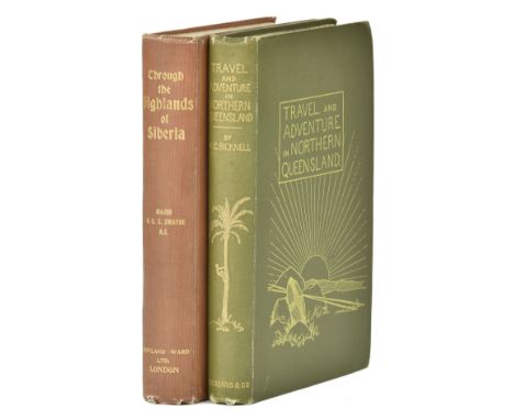
Swayne (Harald George Carlos). Through the Highlands of Siberia, 1st edition, Rowland Ward, Limited, 1904, half-title, frontispiece, folding plate, folding map (partially split along one fold, closed tear to stub), numerous text illustrations (many full-page), 10 pp. advertisements, leaf 2C1 torn in margin, original orange cloth, small nick to foot of spine, light wear to corners, 8vo, together with: Bicknell (Arthur C.), Travel and Adventure in Northern Queensland, 1st edition, Longmans, Green, and Co., 1895, photogravure portrait frontispiece, 24 plates, original green pictorial cloth, spine very gently rolled, slightly frayed at head and foot, corners rubbed, 8vo (Qty: 2)NOTESProvenance (Swayne): Walter Rutherford Peterson Jr. (1922-2011), American politician (bookplate).

Lot 405
Tyndale (Walter) . An Artist In Egypt, 1st edition, 1912, 27 tipped in colour plates, top edges gilt, minor marginal toning, original gilt decorated red cloth, minor rubbing to head & foot of spine, large 8vo, together with Lucas (E.V.) , The Slowcoach, a story of roadside adventure, 1st edition, 1910, black & white title page plus 16 colour illustrations & a map by M.V. Wheelhouse, minor spotting, original illustrated cloth in dust jacket, minor loss to head & foot of spine, 8vo, and Miltoun (Francis) , The Automobilist Abroad, 1907, numerous colour and black & white illustrations, some minor toning, original gilt decorated cloth, spine very lightly rubbed to head, 8vo plus other late 19th & early 20th century illustrated reference & fiction, including G.A. Henry, P.G. Wodehouse, Dorothy L. Sayers, Mary Russell Mitford, many original picture cloth, some in dust jackets, condition is generally good/very good, 8vo (Qty: 3 shelves)NOTESApproximately 90 volumes
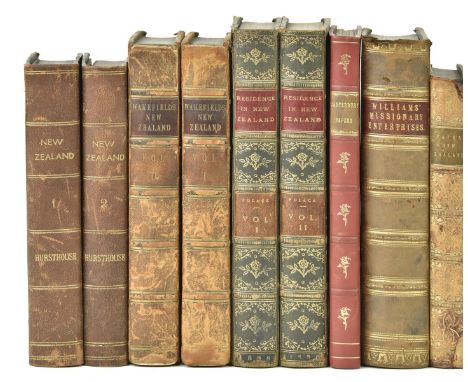
Lot 35
Hursthouse (Charles). New Zealand, or Zealandia, the Britain of the South, 2 volumes, 1st edition, Edward Stanford, 1857, 7 tinted lithographic plates including frontispiece, errata leaf, 2 linen-backed hand-coloured folding maps in end-pockets, frontispiece spotted, maps browned, early-20th-century brown half morocco, together with: [Swainson, William], Auckland, the Capital of New Zealand, and the Country Adjacent: including some Account of the Gold Discovery in New Zealand, 1st edition, Smith, Elder & Co., 1853, folding tinted lithographic panorama as frontispiece, large folding map with partial hand-colouring, both with repairs verso, frontispiece partially torn in gutter, 19th-century ink-stamps (Devon and Exeter Institution) to versos of frontispiece and map and to p. 162 margin, advertisements discarded, contemporary quarter calf, japon fore edges, rubbed, Polack (Joel Samuel), New Zealand: being a Narrative of Travels and Adventures during a Residence in that Country between the Years 1831 and 1837, 2 volumes, 1st edition, Richard Bentley, 1838, 6 aquatint plates including frontispieces, folding map, a little light spotting to plates, frontispieces offset, contemporary blue half calf, rubbed, Wakefield (Edward Jerningham), Adventure in New Zealand, from 1839 to 1844; with some account of the Beginning of the British Colonization of the Islands, 2 volumes, 1st edition, John Murray, 1845, folding map by Arrowsmith (stub-mounted, split in places), contemporary tan calf, gilt arms of the Society of Writers to the Signet to covers, rubbed, joints cracking, and 3 other 19th-century works on New Zealand, leather-bound, all 8vo (Qty: 10)NOTESAbbey 593 for Hursthouse. The panorama and map are often missing from Swainson's work.
Lot 137
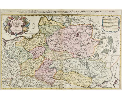
* Poland. Jaillot (Alexis-Hubert), Estats de Pologne subdivisés suivant l'estendue des Palatinats par le S. Sanson, Amsterdam, circa 1675, engraved map with contemporary hand colouring, on two sheets conjoined (as published), elaborate cartouche and mileage scale, 585 x 875 mm, mounted, framed and glazed (Qty: 1)

Lot 154
Yorkshire. Bowen (Emanuel), An Accurate map of the North Riding of Yorkshire divided into Wapontakes..., and An Accurate Map of the West Riding of Yorkshire divided into Wapontakes, Robert Sayer, John Bennett, John Bowles, Carington Bowles, 1777, two engraved maps with contemporary outline colouring, slight staining to North Riding, mount staining to Wset Riding, each approximately 415 x 500 mm, together with An Accurate Map of the East Riding of York Shire divided into its Wapontakes &c..., published C & J Bowles and Robt. Sayer, circa 1765, engraved map with contemporary outline colouring, inset map of 'An Epitomised Map of the East Riding', small panorama of Kingston upon Hull below map, 525 x 660 mm, with four other mid - late 19th century maps of Yorkshire by Smith, Bacon and Weller, various sizes and condition (Qty: 7)
Lot 40
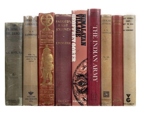
Keyte (J.C.) The Passing of the Dragon. The Story of the Shensi Revolution and Relief Expedition, 1st edition, 1913, portrait frontispiece, map and half-tone illustrations, some toning and light spotting, original cloth gilt (some fading to spine), dust jacket, spine toned with chips and repairs to verso, 8vo, together with Oriental Assembly, by T.E. Lawrence, edited by A.W. Lawrence, 1st edition, 1939, map and illustrations, original cloth, dust jacket, light vertical creases, 8vo, with other travel including James Fergusson's The Palaces of Nineveh and Persepolis Restored: An essay on Ancient Assyrian and Persian Architecture, 1st edition 1851, Farrer's Last Journey. Upper Burma, 1919-20, by E.H.M. Cox, 1st edition, 1926, Mountain Jubilee, by Arnold Lunn, 1943 (inscribed by the author with a letter), and F.M. Bailey's No Passport to Tibet, 1957 (Qty: 37)
Lot 23
Fortune (Robert). Three Years' Wanderings in the Northern Provinces of China, 2nd edition, John Murray, 1847, 3 tinted lithographic plates including frontispiece, additional wood-engraved vignette title-page, map, wood-engravings in text (2 full-page), 16 pp. advertisements, faint damp-staining to upper outer corners of frontispiece and plate facing p. 71, plate facing p.100 slightly marked in margins, quires 2C-D clumsily opened, a few other marks, original cloth, rebacked, extremities worn, 8vo (Qty: 1)NOTESCordier Sinica 2115; Abbey Travel 543 refers. This second edition appeared in the same year as the first.
Lot 126
Jenner (Thomas). A Direction for the English Traviller, by which he shal be inabled to Coast about all England and Wales, 1643, title engraved by Jacob van Langeren, folding distance table, 39 (of 40) engraved cartographical county mileage tables with 'thumbnail' maps, lacking map of Cheshire, Northamptonshire map duplicated, folding general map of England and Wales lacking lower half (the map portion), title laid down, 'The use of all the insueing Tables' leaf laid down with last two lines partly completed in manuscript, a little light spotting and water stains, bookplate of Allan Heywood Bright (1862-1941, British Liberal politician), later calf, spine and edges rubbed, small 4to (Qty: 1)NOTESChubb XLVI; ESTC R38849; Skelton 25. First published in 1635 by Mathew Simmons, in this edition by Jenner "the 'thumb-nail' county maps have been erased, and larger maps on double the scale (10 miles=about 1/2 ins.) engraved in their place in the triangular space in the lower right-hand corner of the plates. The names of towns are given in full, and those in neighbouring counties are added" (Skelton).
Lot 404
Nicholson (John) . Folk Speech of East Yorkshire, limited edition of 100 copies, 1889, book stamp to foot of front endpaper, black & white advertisement to rear, original gilt decorated red cloth, spine lightly rubbed to head & foot, 4to, together with Cromwell (Thomas) , Excursions in the County of Norfolk:..., 2 volumes, 1818, folding county map frontispiece and numerous black & white engraved plates, some light spotting, uniform contemporary gilt decorated green half calf, boards rubbed, spines faded & slightly rubbed to head & foot, 8vo, and Hare (Kenneth) , London's Latin Quarter, 1st edition, 1926, 36 colour and black & white illustrations by Dorothea St.John George, some light spotting & marginal toning, original decorated cloth, spine lightly rubbed to head & foot, 4to, plus other 19th century & modern British topography reference & related, including Cornish reference, publications by Batsford, Christopher Johnson, T.N. Foulis, mostly original cloth, some in dust jackets, G/VG, 8vo/4to (Qty: 6 shelves)

Lot 58
Ross (Sir John & James Clark Ross). Grandes Descubrimientos Polares Terrestres y Maritimos..., three volumes (bound in one), 1st Spanish edition, Barcelona, [1839], title pages with date over-pasted by book seller's label ( Domingo Llorens, Barcelona), additional half titles, engraved folding map bound at rear ( map size 440 x 560 mm), contemporary green blindstamped calf, joints and extremities rubbed, slight loss to upper rear joint, spine slightly faded, 8vo (Qty: 1)NOTESHill (2004) 1490. Sabin 73381. Account of Sir John Ross 's Arctic expedition of 1829-1833, a translation into Spanish of his Narrative of a Second Voyage in search of a North-West Passage. This edition rare, with only 2 copies recorded on WorldCat.

Lot 136
* Poland. Benedicti (Hieronimus), Carte von West-Gallizien welche auf allerhöchsten Befehl Seiner Kaiserlich oesterreichischen und Königlich apostolischen Majestät in den Jahren 1801 bis 1804 unter der Direction des dermahligen General Majors und General Quartiermeisters Anton Mayer von Heldensfeld des militärischen Marien Theresien, Vienna (1808 - 1811), uncoloured engraved map on twelve sheets, sectionalised and laid on linen, 1800 x 2050 mm, framed and glazed (Qty: 1)NOTESFine example of this important early map of Western Galicia, as given to Austria by the third Partition of Poland (1795). Benedicti's map is the first systematic scientific survey of the region, undertaken by the Austrian government. It is based upon an Austrian Survey of the region between 1801 and 1804, conducted under the leadership of Anton Mayer von Heldensfeld (1764-1842), military officer under Archduke Charles of Austria (1771- 1847). While the map bears the date of 1808, the map was in fact prepared between May 1808 and the Summer of 1811, such that by the time the last sheets were completed, Benedicti had died and Western Galicia was no longer a part of Austria.

Lot 26
Graham (Maria). Letters on India, 1st edition, Longman, Hurst, Rees, Orme, and Brown, 1814, engraved folding map frontispiece, 9 etched plates, frontispiece spotted and offset, other plates offset, errata/directions to the binder leaf present, clipped auction description (with lot number 328) tipped to initial blank, endpapers renewed, all edges gilt, contemporary red straight-grain half morocco gilt by Charles Lewis, front joint rubbed, cracking at foot, a little wear to corners, 8vo (22 x 12.8 cm) (Qty: 1)NOTESProvenance: 1) William Beckford (1760-1844), author of Vathek: An Arabian Tale , with his pencilled annotations to the initial blank as usual. 2) Anderson Galleries, New York, 'Rare Books and Autographs from the Libraries of Mrs. May C. Smith and the late Edwin Davis French', 17-21 March 1913. 3) Anderson Galleries, New York, 'Selections from the Purchases and Stock of the Late George D. Smith, Part IV', 23-4 February 1921. 4) Professor Cecil H. Clough (1930-2017), Reader in Medieval History, University of Liverpool. Beckford's annotations include the remark that 'Maria Graham unfortunately so totally unacquainted with any Oriental language that she is obliged to stop the moment her English guides fail - this is candid & does Maria credit'; his own childhood education at Fonthill involved instruction in Arabic and Persian at the hand of his tutor Alexander Cozens.

Lot 147
South America. A collection of 23 maps, mostly 18th & 19th century, engraved and lithographic regional and sub-continent maps, with examples by Luffman, Dower, De Vaugondy, Bonne, Bartholomew, J & C Walker and Sayer, various sizes and condition, together with Cary (John). A New Map of America from the Latest Authorities, 1806, engraved map of the Americas with contemporary hand colouring, some staining and slight offsetting, 480 x 530 mm (Qty: 22)

Lot 60
Shackleton (Ernest). South. The Story of Shackleton's Last Expedition 1914-1917, 1st edition, 1st impression, William Heinemann, 1919, half-title, colour frontispiece with captioned tissue-guard, errata slip tipped to p. 1, all halftone photographic plates as called for, folding map, text-block browned as usual, and slightly bumped at lower outer corners in the second half, old ink-staining to p. 290, folding map partially browned verso from contact with the text, original dark blue cloth lettered and decorated in silver, neatly rebacked with original spine laid down, slightly bumped, rear board rubbed, 8vo (Qty: 1)
Lot 133
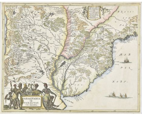
Paraguay. Montanus ( Arnoldus ). Paraquaria vulgo Paraguay cum Adjacentibus , Amsterdam, circa 1675, hand coloured engraved map, small margins, upper margin strengthened, 285 x 365 mm, together with Jansson (Jan). Paraguay, O Prov. De Rio de la Plata cum regionibus adiacentibus Tucuman et Sta. Cruz de la Sierra, [1633], hand coloured engraved map, large strapwork cartouche and mileage scale, central compass rose, 375 x 480 mm, French text on verso (Qty: 2)
![* Hampshire. Speed (John), Hantshire described and devided, Thomas Bassett & Richard Chiswell, [1676], hand coloured engr](https://cdn.globalauctionplatform.com/2032d0fc-fc45-4baa-96fd-aacd0111a502/7b289574-9f7e-4d70-b678-aace012e077c/468x382.jpg)
Lot 125
* Hampshire. Speed (John), Hantshire described and devided, Thomas Bassett & Richard Chiswell, [1676], hand coloured engraved map, inset town plan of Winchester, slight dust soiling, 380 x 505 mm, no text on verso, framed and glazed, together with Saxton (Christopher & Hole Guillaume). Northumbriae comitatus olim sedes Otadinorum [1610], hand coloured engraved map, 'open book' cartouche and large compass rose, 270 x 295 mm, mounted, framed and glazed (Qty: 2)

Lot 121
China. Four various maps, 17th & 18th century, including Blaeu (Johannes). Imperii Sinarum Nova Descriptio, [1655 or later], hand coloured engraved map, some repaired marginal closed tears, some marginal creasing, old folds, 475 x 540 mm, together with Kircher (Athanasius). Imperium Sinicum Quindicupartitum, circa 1688, engraved map with contemporary outline colouring, paper a little brittle with some fraying to margins, 305 x 375 mm, with another untitled map by Kircher of the Taiwanese islands in the South China Sea, 295 x 355 mm, with D'Anville (Jean Baptisite Bourguignon). Carte Generale de la Tartarie Chinoise, 1732, engraved map with contemporary outline colouring heightened with gilt, slight damp staining to lower left corner, narrow margins, old folds, 505 x 800 mm, plus Zatta (Antonio). Indie Orientali, Venice circa 1780, four engraved sheets with contemporary outline colouring, each sheet approximately 330 x 420 mm (Qty: 8)
Lot 69
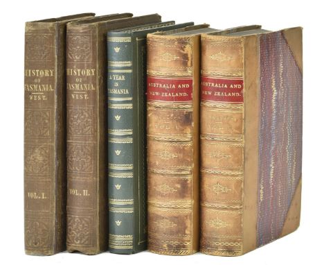
West (John). The History of Tasmania, 2 volumes, 1st edition, Launceston, Tasmania: Henry Dowling, 1852, half-titles, contemporary pencilled ownership inscriptions ('Killymoon'), modern bookplates (R. S. Fox), volume 2 leaves C4-5 held by bottom cord only, small marginal worm-track to final few leaves, inner hinges cracked, original brown cloth, volume 1 rebacked with original spine laid down, both volumes rubbed, tips bumped and worn, 8vo, together with: [ Stoney, Henry Butler], A Year in Tasmania: including some Months' Residence in the Capital; with a Descriptive Tour through the Island, from Macquarie Habour to Circular Head; and a Short Notice of the Colony in 1853, map frontispiece, marginal staining, tears in 2G-H to loss of a few words, modern green morocco, 8vo (21.2 x 13 cm), and Trollope (Anthony), Australia and New Zealand, 2 volumes, 1st edition, Chapman and Hall, 1873, 8 colour maps (all but 1 folding), repairs, spotting, maps of Western and South Australia with closed tears extending from inner folds, ink-stamps to front free endpapers, contemporary tan half calf, rubbed, 8vo (20.9 x 13.4 cm) (Qty: 5)NOTESFerguson 18531 (West), 16294 (Stoney), 17333 (Trollope). Ferguson remarks of West's work: 'An interesting and valuable history of the early period in Tasmania. The work is now scarce'; and of Stoney's: 'Contains very interesting accounrs of the penal settlements'.
Lot 360
Buchan (John). Scholar Gipsies, 1st edition, 1896, etched frontispiece, title and five etched plates by D.Y. Cameron, publisher's list at end, endpapers a little toned, original cloth-backed pictorial buckram gilt, 8vo, together with A Lost Lady of Old Years, 1st edition, 1899, one or two leaves roughly opened, endpapers lightly toned, original green cloth, spine faded to brown, a little rubbed, 8vo, plus The Island of Sheep, 1st edition, 1936, front map endpapers, original cloth, dust jacket, repairs to verso, a few small nicks and tears, 8vo, with others including Sick Heart River, 1941, Montrose, 1928 and Lord Tweedsmuir's The Power of Human Personality, 1949 (presentation copy) (Qty: 74)
Lot 370
Stevenson (Robert Louis). Kidnapped, 1st illustrated edition, 1887, folding map frontispiece, monochrome illustrations, publisher's list at end, a few minor spots, original cloth, slight lean, spine ends a little rubbed, 8vo, together with The Black Arrow: A Tale of the Two Roses, 1st edition, 1888, original cloth, spine faded, one or two small stains, 8vo, plus The Wrong Box, 1st edition, 1889, some spotting, original cloth, spine toned and rubbed at ends, slight lean, 8vo, with 18 others Stevenson related including The Wrecker, 1st edition, 1892 and Island Nights' Entertainments, 1st edition, 1893 (Qty: 21)
-
109198 item(s)/page