We found 109198 price guide item(s) matching your search

Refine your search

Year

Filter by Price Range
  • List
  • Grid
  • 109198 item(s)
    /page

Lot 365

FIVE 18TH AND 19TH CENTURY ENGLISH MAPS, INCLUDING A MINIATURE SPEED MAP OF DERBYSHIRE, ALL HAND COLOURED, VARIOUS SIZES

Lot 347

A BLAEU MAP OF DERBYSHIRE, FRAMED AND MISCELLANEOUS PICTURES AND PRINTS

Lot 1079

ANTIQUE STYLE MAP OF GREAT BRITAIN. Framed and glazed antique style map of Great Britain 39 x 50 cm

Lot 291

A map of Hertfordshire, by Kitchin, together with a book titled 'English Watercolours', and a collection of Perrier prints

Lot 458

'Legal London - A Map Showing the Inns of Court ... AD 1931', designed and drawn by G Spencer Hoffman and inscribed in pencil, published by The Barnard Press, 47 x 60cm

Lot 461

A David Roberts lithograph of a minaret, small map of Persia, by A Findlay, map of The Red Sea, and map of part of The Middle East, in Arabic, 66 x 100cm

Lot 449

A Philips large school room map of the world, showing 'The British Empire and other Colonial Powers and Commercial Highways', published in 1946, 111 x 184cm

Lot 268

A framed & glazed 19th century Henry Teesdale hand coloured map of Rutland. Frame size 50 x 58cm

Lot 180

A vintage German double sided chartometer map measuring wheel, scales are inches to miles/centimeters to kilometers on one side and on the other side are statute miles, kilometers & nautical miles. Together with a vintage hand held compass.

Lot 748

A selection of titles about the battlefields of the First World War including Peter Chasseaud, 'Topography of Armageddon: A British Trench Map Atlas of the Western Front 1914 -1918','The Western Front from the Air', 'Battlefields of the First World War: A Traveller's Guide', 'The Viking Atlas of World War I', 'Chronicles of The Great War' and 'The Macmillan Dictionary of the First World War'.

Lot 30

A vintage twelve sheet road map for motorists of England and Wales, in a leather reveal folder.

Lot 31

A George Philip and Sons vintage ten sheet motorist map, with leather reveal folder.

Lot 314

Railwayana; a quantity of books and printed ephemera, including a map of the Frontier Stations of Europe, station diagram after the Hertford North rail collision 6th February 1978, Instructions on conveying Armoured Fighting Vehicles by rail 1957, British Rail Rule Book 1950, and S&C planning diagrams around Cambridge, Wisbech, Ely and Spalding.
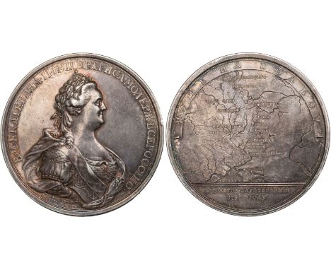
Lot 517

Group of assorted furnishing prints, map etc. (9)

Lot 545

A collection of assorted furnishing pictures to include prints, nude study in pencil by C. Hopkins, small cottage study in watercolours, other watercolours, map etc. (18)

Lot 561

Two 19th Century framed topographical prints, 'Carmarthen' and 'Cardigan' and a framed map of Carmarthenshire. Hogarth frames. (3)

Lot 277

A 17th century Continental map, together with a small quantity of 19th century and later cartoons and pictures.

Lot 303

A map of Bedfordshire, Cambridgshire, Essex, Middlesex and Buckinghamshire, hand-coloured. H: 55cm W: 70cm

Lot 273

F. De Wit, map of Wurtsburg, Bamberg & Aichstet, coloured, 54 x 64cm.

Lot 250

A Large Vintage English Ordinance Survey Map. a World map. Pictures, Prints, along with a chair and cabinet.

Lot 457

FOREIGN COINS, China, Chinese Soviet Republic, misstruck 5 cents, undated (c.1932), chinese characters within wheat-ears, star above, rev. hammer and sickle on outline map (KM.Y507), good fine, struck off-centre, rare thus

Lot 577

G FOREIGN COINS, Oman, proof 5 rials, AH.1411 (1991), Year of Industry, national arms, rev. map flanked by cartouches depicting industrial scenes, .917 fine, wt. 20gms. (KM.90; Fr.13), in case of issue, FDC Mintage of 410.

Lot 574

G FOREIGN COINS, Oman, proof 15 rials, AH.1406 (1985), 15th National Day, head three-quarters l. within wreath, rev. crowned arms over country map within circle, .917 fine, wt. 20gms. (KM.56; Fr.9c), in case of issue, FDC Mintage of 2000.

Lot 405

COMMEMORATIVE MEDALS, FOREIGN MEDALS, Russia, Catherine II, the Great, Triumphal Voyage of the Empress to Crimea, celebrating the 25th Anniversary of her reign, 1787, silver medal, by Timothei Ivanov, bust of the Empress r., wearing classical armour, mantle over her shoulders, rev. a map of Russia, in considerable detail, her route depicted with a dotted line, legends in Cyrillic, 65mm. (Diakov 205.1; Smirnov 304 var.), about extremely fine, very rare
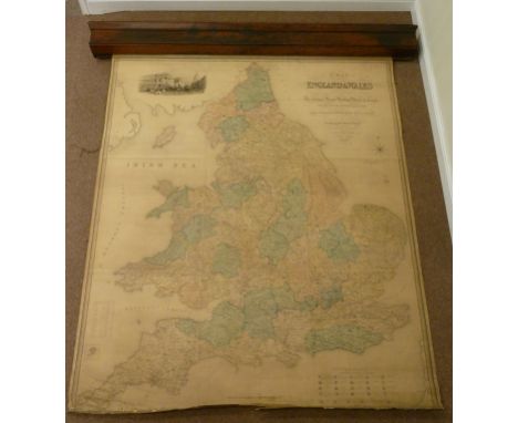
Lot 578

G FOREIGN COINS, Oman, proof 5 rials, AH.1411 (1991), Year of Industry, national arms, rev. map flanked by cartouches depicting industrial scenes, .917 fine, wt. 20gms. (KM.90; Fr.13), in case of issue, FDC Mintage of 410.

Lot 576

G FOREIGN COINS, Oman, proof 5 rials, AH.1411 (1991), Year of Industry, national arms, rev. map flanked by cartouches depicting industrial scenes, .917 fine, wt. 20gms. (KM.90; Fr.13), in case of issue, FDC Mintage of 410.

Lot 575

G FOREIGN COINS, Oman, proof 5 rials, AH.1411 (1991), Year of Industry, national arms, rev. map flanked by cartouches depicting industrial scenes, .917 fine, wt. 20gms. (KM.90; Fr.13), in case of issue, FDC Mintage of 410.

Lot 275

Robert Morden, Leicestershire, monochrome map, 36cm x 42cm, folded sheet and a John Speed, both County and City described, monochrome map, 38cm x 51cm, folded sheet.

Lot 494

A brass map reader compass, in a wooden box

Lot 30

After Gerard Mercator (1512-1594): Tab: IX. Asiae, Continens Ariam, Paropanisum, Drangianam, Arachosiam, et Gedrosiam, a hand coloured engraved Ptolemaic map of Central Asia, centered on the Indus River, originally published in the 1578 edition of Ptolemy's Geographia

Lot 438

Amstelodami, Apud Ioannem Ianßonium _ Map of Devonshire, 53 x 41cm, framed and glazed

Lot 280

Framed Minefield Situation 5th September 1982 map relating to Poet Stanley area, Falkland Islands

Lot 295

Large double sided map of south and north Japan

Lot 21

A large map book of the county of Essex from an actual survey by John Chapman and Peter Andre.

Lot 156

An oak framed coloured map of Lancaster by Saxon.

Lot 20

A large folder of assorted map pages.

Lot 110

A framed coloured Penguin Map of the World by Michael Middleditch.

Lot 76

Italy Stereo Card Set. Boxed full set of 100 Underwood & Underwood stereo cards "Italy Through the Stereoscope" (100 out of 100) with book and location map. (condition 5)

Lot 74

Holy Land Stereo Card Set. Boxed complete set of 100 Underwood & Underwood stereo cards "Palestine Through the Stereoscope" (100 out of 100) with "Travelling in the Holy Land Through the Stereoscope" book (correct book for this set). Location map included. (condition 5).

Lot 171

Large antique retractable Ordnance Survey map of England and Wales drawn by R. Creighton, engraved by J. Dower and published by S. Lewis and Co., dated 1839, in mahogany case H210cm x 173cm (W200cm overall) Condition Report Generally reasonable condition for age. Cloth 'seems' missing in places. Some deterioration and loss of canvas at the bottom of map (as illustrated) some creases at the bottom becoming open cracks. Otherwise good with colour you might expect from age.

Lot 150

Framed hand coloured map of Gloucester

Lot 174

Salter parcel post balance scale, map measure, Loris wrist watch on metal strap, mother of pearl fruit knife, bone advertising bookmark 'E W Jackson & Son, Frenchgate, Doncaster'

Lot 1403

A Regency ebony parallel ruler - 30cm - with brass fittings, a brass map magnifier and an early 19th century circular magnifying glass in silver frame and turned handle in sleeve - silver frame not hallmarked

Lot 1600

A coloured map of lands belonging to the Manors of Pembrooke, Parishes of Tottenham and Edmonton by Thomas Clay dated 1619 - 38cm x 64cm and a 1793 map of Essex by J. Cary - 23cm x 28cm Condition report: Clay map generally good, colours bright, Cary map appears to be glued and varnished

Lot 92

After John Speed (1552-1629): a map of 'Rutlandshire with Oukham and Stanford', with detailed cartouches of 'Oukham' and 'Stanford', hand coloured, published by Sudbury and Humbell, 38 by 51cm.

Lot 183

Militaria: Hitler's Mein Kampf, the complete English version of eighteen editions, translated by James Vincent Murphy, together with John Cary's Reduction map of England and Wales, 1837, with folding linen backing.

Lot 565

JOHN HOWARD (b.1958) - 'Disused viaduct, Digbeth', etching, signed in pencil and numbered 10/25, dated 1991, framed, 51cm x 40cm also a 19th century map of Birmingham (2)

Lot 1104

An American gold plated Pocket Watch (damaged) Compass and Map Measure

Lot 183

A 19th century wall map of Scotland, 183cm long CONDITION REPORT: Lot 183 - tear to right corner

Lot 147

VINTAGE LINEN WALL MAP OF SOUTH AFRICA 152cm across

Lot 155

VINTAGE LINEN WALL MAP OF THE BRITISH ISLES 75 cm across

Lot 226

GROUP OF SEVEN VINTAGE REPRODUCTION MAPS each framed; including a Saxton's reporduction map of Lancashire of 1577, a Saxton's reproduction map of Monmouthshire of 1577, a reproduction map of Oxfordshire, etc; the largest 50cm x 62cm

Lot 305

LARGE 1828 SCOTTISH MAP OF NORTH AYRSHIRE AND GLASGOW 68cm x 53cm mounted, framed and under glass

Lot 2191

Mundy, Godfrey Charles. Journal of a Tour in India, third edition, plates, 32pp. publisher's catalogue at end, original cloth, 8vo, London: John Murray, 1858; Davidson, C.J.C. Diary of Travels and Adventures in Upper India, 2 volumes bound in one, some spotting, later half morocco, rubbed, 8vo, London: Henry Colburn, 1843; [Anon] The Tourist's Guide to Lucknow, eighth edition, plates, folding map, original cloth-backed boards, 8vo, Lucknow: Murray's Press, 1913; and 26 others India, v.s. (29)

Lot 2164

Rutter, John. An Illustrated History and Description of Fonthill Abbey, first edition, half-title, dedication leaf, 9pp. list of subscribers, 13 engraved plates, including 3 hand-coloured, folding engraved map, hand-coloured in outline, wood-engraved vignettes, contemporary straight-grained morocco gilt, boards detached, bookplate of John E. Pritchard, folio, Shaftsbury: John Rutter, 1823

Lot 2224

Teesdale, Henry. A New General Atlas of the World... containing separate maps of its various countries and states... also the British and Foreign Railways, completed and projected, double-page title and list of contents, 46 double-page hand-coloured engraved maps, the two sheets for India combined with folds backed by linen, double-page chart of the mountains and rivers of the world, some surface soiling, the folding map torn, several maps torn along fold, contemporary full morocco gilt, all edges gilt, folio, London: Henry Teesdale, 1844
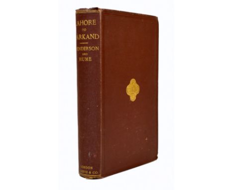
Lot 2403

Elphinstone, Hon. Mountstuart. An Account of the Kingdom of Caubul…, New and Revised Edition, 2 vols., 1842. 8vo., orig. cloth (joints split, spines crudely repaired). Hand coloured aquatint frontispieces, folding map and one plain plate (stained at top edge) (2)

Lot 2184

Henderson, George and Allan O. Hume. Lahore to Yarkland. Incidents of the Route and Natural History of the Countries Traversed..., first edition, half-title, 16 heliotype plates, 38 hand-coloured plates of birds and plants, 3 geological sections, 2 hand-coloured, folding map, a few leaves with minor tears, not affecting text, 16pp. publisher's catalogue at end, original cloth gilt, 8vo, London: L. Reeve & Co., 1873

Lot 2388

Biography and memoirs, nineteenth century. Malcolm, Sir John. The Life of Robert, Lord Clive, 3 vols., 1836. Cont. black morocco gilt, a.e.g. by Hering (slightly scuffed). Portrait and map. Presentation copy inscribed to Lord Fitzroy Somerset from Charlotte Malcolm. With 36 others including further presentation copies. Orig. cloth. All 8vo. (39)

Lot 2420

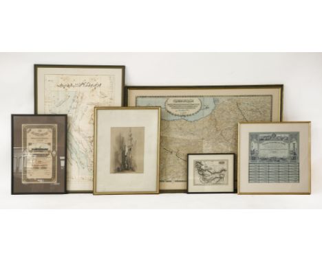
India. Napier, Lt. Gen. Sir William. History of General Sir Charles Napier's Administration of Scinde, 1851. Tinted lithographic plates and folding maps - Mackenzie, Mrs. Colin. Life in the Mission, The Camp and The Zenana…, Second Edition revised, 1854. Plates and plans - Duff, James Grant. History of the Mahrattas, 3 vols., [Indian reprint], Bombay 1863 -Malleson, Maj. G.B. History of the French in India, 1868. Folding map and 2 other maps, errata slip - Dow, Alexander. The History of Hindostan. Trans. From the Persian, New Edition, 3 vols., 1803. Cont. half roan (old signatures on titles crossed out, title of vol 1 repaired). Folding map, 6 plates and alphabet specimen plate - Macmunn, Sir G.F. The Armies of India, A. & C. Black, 1911. Colour plates. 8vo., orig. cloth unless otherwise stated. With 11 others (23) See illustration

Loading...Loading...
  • 109198 item(s)
    /page

Recently Viewed Lots