We found 109182 price guide item(s) matching your search

Refine your search

Year

Filter by Price Range
  • List
  • Grid
  • 109182 item(s)
    /page

Lot 737

EARLY MAP, Robert Morden, hand coloured engraved map "Small Islands In The British Ocean", 14" x 16.5"

Lot 738

JOHN SPEED, 17th Century hand coloured map "Merionethshire" with glazed text on reverse, 15" x 19"

Lot 739

EARLY MAP, Robert Morden, hand tinted map "Monmouth", 13" x 16"

Lot 772

EARLY MAP, Robert Morden hand coloured "East Riding of Yorkshire", 14" x 16"

Lot 792

18th CENTURY MAP, "City of Bath", 19" x 15"

Lot 445

T Kitchin - 19th Century coloured engraving Map of Cumberland and quantity of prints etc

Lot 691

Fullerton's map of Cumberland, 1830, framed and mounted

Lot 346

Framed map of Surrey and other

Lot 364

Geoffrey Coning - map - England's Lakes and Fells and Velazquez print

Lot 383

Framed O/S map of Long Marton

Lot 882

V Geeson, 4 silk work embroideries, bird studies, a pair of framed map prints, and a watercolour, Venetian scene, framed (7)

Lot 900

An Antique hand coloured map, Leicestershire, framed

Lot 247

Antique framed map of the West India Islands, engraved by Birkwood Edinburgh, height 22.5" overall

Lot 492

A framed map of Kent, dedicated to Winston Churchill by the Lord Warden of Cinque Ports

Lot 140

Two rolled prints of vintage steam trains a rolled underground map of film locations two cushions and a railway plate

Lot 5228

Railwayana - Cartography - map showing the lines of The North Eastern Railway and Connections 1902, published by Chorley & Pickersgill, The Electric Press, Leeds, lithographed in polychrome, dissected into twenty five squares and laid on linen, 111cm x 88.5cm

Lot 193

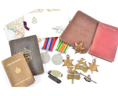
An interesting First and Second World War Father and Son group of medals and ephemera, including of a pair of WWI medals comprising British War Medal and Victory Medal named to 161837 GNR. William Gibson. Royal Artillery, and four WWII medals issued to William Gibson (Royal Artillery) comprising Africa Star, War Medal, 1939-45 Star and Territorial Efficiency Medal. With eight WWI silk postcards including several sent from W. Gibson Snr. to his son and another to his wife. Together with a Royal Artillery cap badge. Also with various official letters and ephemera, soldier's pay book, Christmas 1942 hymn book, Dunkirk Memorial certificate and medal, map of German POW camps in Europe and William Gibson Jnr.'s dog tag from when he was held at camp 'Stalag XI A'. (Qty)

Lot 257

JOHN SPEEDE two unframed coloured and tinted map of Denbighshire and Flintshire, sold by Thomas Bassett in Fleet Street and Richard Chiswell in St Paul's Churchyard and Roger Rey the Elder and the Younger at the Golden Cross in Cornhill, 39 x 51.5 cms and 39.5 x 51 cms respectively, 17th Century and later

Lot 258

Rare Overton Atlas map of North Wales, unframed with slight colour tinting and town plans to the vertical margins, the publisher's imprint stating 'Sold by Henery Overton at the White Horse, Without Newgate, London', circa 1710 from plates held in possession of the 1614 edition John Speede Atlas, Fleur de Lys over shield watermark, 39 x 51.5 cms

Lot 259

JOHN SPEED map of Anglesey, double page engraving, uncoloured and unframed, sellers Thomas Bassett and Richard Chiswell, dated 1610, 39 x 51.5 cms

Lot 260

JOHN SPEED coloured tinted map of Caernarvan, both shyre and shire-towne, with the ancient citie, Bangor described, double page engraving with inset vignettes showing aerial views of Caernarvan and Bangor, sellers Thomas Bassett and Richard Chiswell to the publisher's imprint, unframed 39.5 x 51.5 cms

Lot 261

JOHN SPEED map of 'Penbrokshyre', unframed coloured double page engraving, sellers Sudbury & Humbell, dated 1610, 40 x 52 cms

Lot 302

Brass and iron footman, Daily Mail WWII Western Front map, Whip Wilson film poster, a copy of 'The Works Of Peter Pindar 1809' and a vintage metal skillet

Lot 266

Three WWI Air Force 'Air Packet' map sets, all complete, comprising No.50 I.D 1090 (Wales, Isle of Man and Ireland), No.46 I.D 1083 (Scotland, North of England and North of Ireland) and No.47 I.D 1084 (South of England) (parcel)

Lot 283

A collection of photographs and ephemera relating to the Falklands, Northern Ireland and Allied Forces Day 1983, comprising Regimental photographs, hand drawn cartoons, training books, map and more (parcel)

Lot 377

A 10th Battalion Royal Berkshire WWII medal group, awarded to L/CPL R D SHEPPARD, together with his ID wrist strap, badges, sweetheart pin badge, Service and Pay book, b/w photograph, Christmas card, silk map of Spain/France and other ephemera (parcel)

Lot 569

A pair of WWII or later nautical binoculars, possibly Barr & Stroud, together with a tin map cannister containing several Hong Kong and surrounds maps (2)

Lot 128

Collection of UK road maps and travel guides including, linen-backed 'Georaphia - Map of Central Counties', Bartholomews Holland's Patent linen-backed England and Wales South, and a quantity of BP Shell Shilling Guides.

Lot 239

Guliel Hole after Christopher Saxton, "Universi Derbiensis Comitatus qui olim Coritanorum fuit descriptio", hand-coloured county map, 28 x 31.2cm.

Lot 687

A 17th century county map engraving by Norden & Hole, Hamshire (sic), 30 x 30 cm, to/w another map 'Hantshire' (sic) by Speede & Hondius, 37 x 52 cm (2 - both framed)

Lot 688

An 18th century engraving of The East Prospect of the City of Winchester, after Samuel and Nathaniel Buck 1738, to/w two antique map engravings of Winchester (3 - all framed)Significant staining and watermarks on Winchester panorama 

Lot 740

Saxtons map of Suffolk, Map of Suffolk with depiction of Hadleigh Church, coloured prints of Swansea and Aberdare Church Glamorganshire, black and white print of Jedburgh Abbey (5)

Lot 18

Antique Geological Map of the Isle of Wight - framed and glazed CONDITION REPORTT.WEBSTER delinPUBLISHED BY PAYNE & FOSS - PALL MALLJ.WALKER sculpt

Lot 61

Suitcase containing: rubberised RAF WWII map of Malaga, album of match box comes from around the world, a bag of stamps, a porcelain head of a Putti, Green Hawk tennis racket, commemorative plates, clay pipe & pot bases

Lot 62

A late 18th / early 19th century map of Buckinghamshire, hand-coloured engraving after John Speed, framed and glazed, 51 x 31cm

Lot 361

REPRODUCTION OF A 17th CENTURY JOHN SPEED MAP OF DERBYSHIRE

Lot 327

Blaeu?, 17th century engraved map of Lancastriae, 30 x 31cm

Lot 147

A vintage local area interest map print after Wainwright

Lot 151

A vintage local area interest map print after Wainwright with aquatinted colouring

Lot 234

A vintage print of Saxton Map of Cheshire

Lot 241

A vintage map print of Herefordshire

Lot 2128

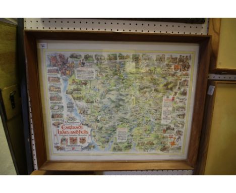
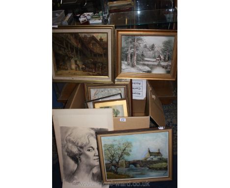
A quantity of prints and pictures including a Map of Herefordshire, Joel Kirk German Shepherd, E.M Bennett print on canvas of a courtyard scene with stagecoach and figures, oil on canvas signed Cantrell of a winter alpine scene and an oil on board by J. Lyall of a cottage by a stone bridge crossing the river etc

Lot 1006

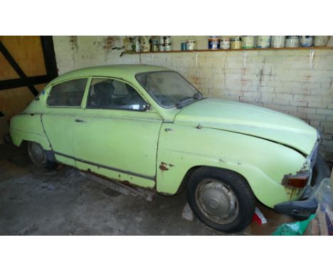
1975 Saab 96L, 1,498 cc. Registration number LSD 477P. Chassis number 96760000427. Engine number 360236. The Saab 96 was manufactured 1960 to January 1980, replacing the 93. The 96 featured aerodynamic two-door bodywork, four passenger seating and at first a two-stroke, three-cylinder engine, later a four-stroke V4. In 1967, Saab began marketing the 96 V4, with the Ford Taunus V4 engine, a four-stroke 1498 cc engine, originally developed for the 1962 Ford Taunus 15M. The two-stroke option was offered until 1968. The front suspension used double wishbones and coil springs, while the rear suspension was a trailing U-beam axle with coil springs. Telescopic dampers were used for all four wheels, in 1967, with the coming of the V4 engine; models were fitted with front disc brakes. The 96 was driven most famously by Erik Carlsson, in many international rallies. His most famous successes were first in the 1960, 1961 and 1962 RAC Rallies and first in the 1962 and 1963 Monte Carlo Rallies. It was these successive, top-level victories that put the Saab 96 'on the map' and established its reputation for reliability and toughness. LSD was first registered on the 22nd December 1975 and bought by Michael Reynolds of Glasgow in 1984, he sold it to our vendor in May 1989 who in 1992 drove it into the garage of her parents’ home and left it there. Dry stored ever since the property is being sold and the car has to be moved on. It will need restoring but appears mostly original. Sold with the V5C and SORN notification, this should be a rewarding restoration for the next custodian.

Lot 135

A special build Triumph 750 cc engine, composed of a 1959 crankcase, 1963 crank and head, MAP of Florida billet cylinder with forged heat treated pistons, Map manifold, Mikuni carb., BTH magneto, Thunder Engineering con rods. This engine cost in excess of Å“3,500 and has covered some 9,500 in the 1956 Triumph T110, registration UNY 710 offered elsewhere in the sale.

Lot 261

Canvas hanging wall map (width 105cm)

Lot 234

Stenson Cooke "This Motoring" hardback Book, Contour Map book of Great Britain and a vintage AA Map of England & Wales

Lot 409

Framed and Glazed Map of Dorset, Framed and Glazed Etching of Caversham Park and Framed and Glazed Picture of a Woman on a Bicycle with a Quotation from the Daily Mail 1961 regarding Bollinger Champagne

Lot 553

Ordnance Survey Coloured Geological Survey Map of North Wales, reprinted 3rd impression 1968, 52cms x 75cms, framed and glazed

Lot 599

Antique Hand Coloured Map Engraving of Anglesey and North Wales, 40cms x 50cms, framed and glazed

Lot 656

Framed and Glazed Plan of Pianta di Cracovia together with a Framed and Glazed Antique Hand Coloured Map Engraving of Europe ', 55cms x 83cms

Lot 1396

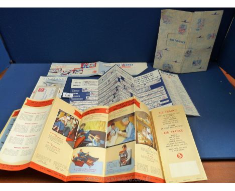
A collectable old Air France folder and leaflets within including a large Routes flow Map referring to the aircraft of the time including ''Super Constellation by Lockheed and the Vickers Viscount'' with views in colour of the interiors, a Drinks Tariff leaflet, a Western Europe and North Africa map with strip rout charts, etc.,

Lot 133

A framed ordnance survey map of Suffolk, 72 x 104cm, together with a pair of prints of Lord Nelson (3)

Lot 497

P Sellier, 19th century, portrait of a lady, watercolour, oval, 28 x 22cm, together with two other portraits, a map and figures by a wall (5)

Lot 730

Geographical pictures of Africa in three boxed sets, with pamphlets and map of East Africa

Lot 103

TALISKER 10 YEARS OLD MAP LABEL Single Malt Scotch Whisky 70cl, 45.8% volume.

Lot 113

TALISKER 10 YEARS OLD MAP LABEL Single Malt Scotch Whisky 70cl, 45.8% volume.

Lot 123

TALISKER 10 YEARS OLD MAP LABEL Single Malt Scotch Whisky 70cl, 45.8% volume.

Lot 152

TALISKER 10 YEARS OLD MAP LABEL Single Malt Scotch Whisky 70cl, 45.8% volume, in carton.

Lot 64

TALISKER 10 YEARS OLD - MAP LABEL Single Malt Scotch Whisky 70cl, 45.8% volume.

Loading...Loading...
  • 109182 item(s)
    /page

Recently Viewed Lots