We found 109198 price guide item(s) matching your search

Refine your search

Year

Filter by Price Range
  • List
  • Grid
  • 109198 item(s)
    /page

Lot 291

Framed & glazed hand coloured map of Norfolk by Robert Morden 55 x 75cm.

Lot 275

Baedeker (Karl). Handbook for Travellers, Central Italy (1893), Northern Italy (1899), Belgium and Holland (1885), Rhine (1886), an Antiquarian Travellers map of Spain and Portugal, and Harriet Martineau's Complete Guide to the English Lakes, red cloth binding, spine in poor condition, (6). Provenance: Ex Duddington Manor

Lot 493

After Dendy-Sadler. An Edwardian print depicting map reading in the study, signed in pencil by Sadler and another.

Lot 499

An 18thC hand coloured engraved map of Chile and Paraguay, after Homann Heirs 1733, with town plan of Santiago, 75cm wide, 68cm high.

Lot 507

A late 17thC hand coloured map of Norfolk by Robert Morden, 58cm x 38cm.

Lot 508

A mid 17thC map of the Kingdome of Scotland by John Speede, featuring portraits to left and right hand margin, dated 1652, in dual glazed frame having Scotland's Generall Description in text to verso, 50cm x 40cm.

Lot 510

A 17thC map of Devonshire, with Execester having coat of arms to the left margin by John Speede, on dual glazed frame depicting pages of Devonshire to verso, 50cm x 40cm.

Lot 511

A 17thC map of The North and East Ridings of Yorkshire, with inset detail of Hull and Richmond by John Speede, in dual glazed frame with pages of Ridings of Yorkshire to verso, 53cm x 40cm.

Lot 512

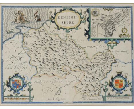
A late 17thC uncoloured map of Norfolk, with the Covntie Armes of Svch Florishing Noble Familes and Popvlovs as have Borne described the titles and devided therof, with detail of Norwiche and Rebellion scene by Christopher Saxton / John Speede, in dual glazed frame having pages of Norfolcia, 51cm x 40cm.

Lot 513

A 20thC reproduction of the 1742 map of Boston, detailing The Stump and Market Cross, 59cm x 47cm.

Lot 513A

A 19thC map of Rutlandshire by John Cary, 26cm x 21cm.

Lot 1150

JOHN SPEED CARDIGAN-SHYRE double page engraved map from The Theatre... 1611, mounted to platemark, 39.5 x 52cm ++In very good condition, no apparent repairs and clean. In modern Hogarth frame with non reflective glazing medium and the back in glass by Ian Cowley, Nottingham

Lot 1151

JOHN SPEED ANGLESEY double page engraved map from The Theatre... 1611, mounted to platemark, 39.5 x 52cm ++Small closed tear and tiny spot of foxing lower centre, otherwise very good condition and clean. Framed as the preceding lot by the same

Lot 1152

JOHN SPEED RADNOR double page engraved map from The Theatre... 1611, hand coloured, mounted to platemark, 39.5 x 52cm ++In apparently good condition and clean, the reverse inscribed in the margin in ink Montgomerie (correcting Monmouth), framed as the two preceding maps by the same

Lot 1153

JOHN SPEED DENBIGHSHIRE double page engraved map from The Theatre... 1611, hand coloured, mounted to platemark, 39.5 x 52cm ++In apparently good condition with light staining and solitary brown spot in upper border. Ring mark verso, framed as the three preceding maps by the same

Lot 1154

JOHN SPEED MONTGOMERY SHIRE double page engraved map from The Theatre... 1611, hand coloured, mounted to platemark, 39.5 x 52cm ++In apparently very good condition, framed as the four preceding lots by the same

Lot 1155

JOHN SPEED CAERMARDEN double page engraved map from The Theatre... 1611, hand coloured, mounted to platemark, 39.5 x 52cm ++In apparently very good condition framed as the preceding maps by the same

Lot 1156

JOHANES BLEAU DENBIGH ET FLINTSHIRE double page engraved map from The Atlas Novus... 1672, Spanish text, hand coloured, mounted to platemark, 39.5 x 51.5cm ++In apparently very good condition, mounted as the preceding maps by the same

Lot 1157

JOHANES BLEAU GLAMORGAN SHIRE double page engraved map from The Atlas Novus... 1672, Spanish text, hand coloured, mounted to platemark, 39.5 x 51.5cm ++In apparently good condition, framed as the preceding maps by the same, glass on reverse cracked

Lot 1158

JOHANES BLEAU BREKNOKE double page engraved map from The Atlas Novus... 1672, French text, hand coloured, mounted to platemark, 40 x 52cm ++Good condition but lightly browned, framed as the preceding lots probably by the same

Lot 1159

JAN JANSSON BRITANNIA... double page engraved map of the British Isles showing the Anglo Saxon heptarchy from the Atlas Novus, Amsterdam 1646-66, finely hand coloured, mounted to platemark, 42.5 x 53.5cm ++In apparently excellent condition as when purchased in the 1980s by the vendor from a member of the specialist trade and at that time placed into the present mount and frame since when undisturbed

Lot 1160

ABRAHAM ORTELUIS BRITANNICARUM INSULARUM TYPUS double page engraved map from the Theatrum Orbis Terrarum, Antwerp 1595, hand coloured, mounted to platemark, 37 x 51.5cm ++In the same excellent condition as when purchased in the 1980s by the vendor from the specialist trade and at that time placed into the present mount and frame since when undisturbed

Lot 1161

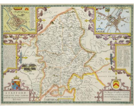
JOHN SPEED STAFFORDSHIRE double page engraved map from the 1627 edition of Speed's Theatre..., hand coloured, trimmed to platemark, 39.5 x 51.5cm ++Repaired tear extreme lower right just clear of frame line, light overall discolouration but acceptable. In the same condition as when purchased in the 1980s by the vendor from a member of the specialist trade and placed in the present mount and frame at that time and since undisturbed

Lot 1177

THOROTON (ROBERT) THE ANTIQUITIES OF NOTTINGHAMSHIRE....EXTRACTED OUT OF RECORDS ORIGINAL EVIDENCES LEIGER BOOKS OTHER MANUSCRIPTS AND AUTHENTICK AUTHORITIES folio, map and some plts substituted with other antique engravings, several pages replaced in fine 18th century copperplate handwriting, recent half morocco, 1677

Lot 1182

THOROTON (ROBERT) THE ANTIQUITIES OF NOTTINGHAMSHIRE... .EXTRACTED OUT OF RECORDS ORIGINAL EVIDENCES LEIGER BOOKS OTHER MANUSCRIPTS AND AUTHENTICK AUTHORITIES folio, map and plts, several folding, bookplate of the Earl of Portsmouth, 18th c russia, rebacked, 1677

Lot 1186

GEORGE (H B) THE OBERLAND AND ITS GLACIERS EXPLORED AND ILLUSTRATED WITH ICE-AXE AND CAMERA photographically illustrated with albumen prints by Ernest Edwards, double page map, green cloth gilt, aeg, 1866 Gernsheim (Incunabula of British Photographic Literature), No 327

Lot 1233

BEDDINGTON (W R ) A HISTORY OF THE QUEEN'S BAYS (THE 2ND DRAGOON GUARDS) 1929-1945 illustrated, folding plans and double page map, half title, presentation scarlet morocco gilt with insignia and raised bands, inscribed on the ffe Presented to Brig J J Kingstone, CBE, DSO, MC on his retirement as Colonel; of the Queen's Bays by all ranks of the regiment in grateful appreciation ++In fine condition

Lot 1110

A Treatise of the Situation, Manners and Inhabitants of Germany and The Life of Agricola by Cornelius Tacitus, translated by John Aikin MD, with Map of Antient Germany. Published 1805

Lot 794

18th century underglaze blue lidded pot, an etched candle with a map of devonshire, a leather cased stirrup cup and a mdina type vase

Lot 949

Hand coloured map of Britain and France, in french marked Chatecain and 1672 Charles II

Lot 956

19th century hand coloured and engraved map depicting the west riding of yorkshire featuring wakefield school

Lot 957

Westmoria comitatvs anglice westmorland. Hand coloured map with visable reverse marked John Bleau 1646 Charles I

Lot 964

19th century copy of an earlier map of wales named montgomeri and dated 1578

Lot 966

Large hand coloured map showing part of Lancashire marked Emanuel Bowen 1760 George III

Lot 968

Early 19th century Map Sampler depicting the British Isles in a period oval frame and embroidered with a foliate border

Lot 969

Hand coloured detailed map of Great Britain marked Leonardi Valk 1705 Queen Anne

Lot 979

Exquisite hand coloured map of Artesia in latin and marked to the reverse 1620 P Kearius and measuring 52 x 42 cm

Lot 984

Coloured map "The pedestrians companion, Fifteen Miles around London" printed by M J Godwin & Co Publishers dated 1822. folded into its original book type cover

Lot 985

Eboracensis Pars Orientalis The east riding of yorkshire. Hand coloured map marked John Bleau 1646 Charles I

Lot 988

The Countie of Westmorland and Kendale the chief towne, hand coloured map marked John Speed 1743 Anne 56 x 43 cm

Lot 993

The description of Leicestershire by W Burton Esq complete with map and dated 1777

Lot 994

Gerard Mercator 1609-1610 a rare framed hand coloured map dated circa 1609 42 x 35 cm

Lot 997

Hand coloured map "The north riding of yorkshire" marked R .Morden 1688 James II

Lot 1540

Reference books - cookery, carpentry, railways, dolls houses, map of North Riding etc

Lot 566

A quantity of post 1945 German Army leather equipment similar to Third Reich, including 3 map cases, pair SMG triple mag pouches, pair of Infantry triple pouches, “Y” straps, waistbelts etc. GC

Lot 311

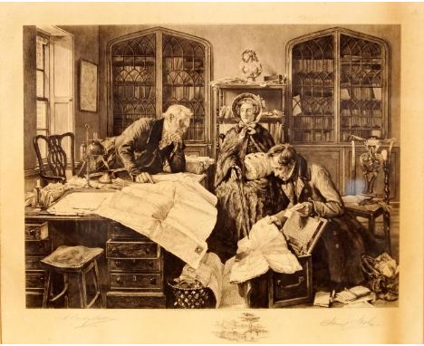
A most interesting Georgian bandsman’s painted tambourine, the 3” deep outer frame, incorporating 6 thin brass jingles, painted with Garter Stars on the outside, and trophies of instruments on the inside, with maker’s name “G. Ouldney (? unclear) & Co, 20 Soho Square, London”, thin hide top secured by 8 iron screw tensioners, diameter 18”, with old stitched repair, and traces of a map (?) drawn on the inside. Basically Good Condition for age (small splits to hide) Plate 64. Note: tambourines were used by bandsmen of African origin in the Brigade of Guards.

Lot 93

COLLECTABLE BOOKS - excellent assortment of 34 collectable books covering subjects such as travel, art and nature. Highlights include 1914 Mersey Docks diary (with maps of all docks), Pattisons Cyclists Road Map of North Wales, Motor Tours from Cardiff (Whereiwent Series), 1914 Panama Canal Souvenir, Story of Baden Powell (Begbie 1900), English in Egypt with Life of General Gordon (Sangster), Tripoli to Godames, Antoine Watteau Masters of Painting (1925 The Studio - S Sitwell), Silver & Golden Bells (Constance Harrison 1898) and many more.

Lot 112

A 17th century map of Nottinghamshire by Richard Blome, c.1673

Lot 22

An early map of Staffordshire by Robert Morden

Lot 167

A Framed Coloured Map of The Monastery Shrewsbury.

Lot 171

A Framed Coloured Map and Framed Details of the Battle of Corunna, 1809 (Limited Edition)

Lot 468

An 18th century map, Robert Morden, Westmorland, later coloured

Lot 420

Four various Poole Pottery plates and dishes including a Poole Harbour Map plate.

Lot 1234

Antique hand coloured map ' Zeelandia ' by Blaeu, in a Hogarth type frame together with another similar

Lot 1287

Small framed antique hand coloured map of Ireland together with a maple framed Kronheim print of a Bacchanalian scene

Lot 1289

19th Century hand coloured map of Dublin by Rapkin in a good quality modern frame

Lot 1360

Robert Morden, hand coloured map of Hampshire, 15ins x 17ins and John Kerry, early 19th Century hand coloured map of Devonshire, together with a modern print of a map

Lot 1475

Antique print of St. Bartholomew's Hospital, an antique map of Wiltshire dated 1857 and two small engravings of Richmond

Lot 1514

Robert Morden antique handcoloured map of Ireland, gilt framed

Lot 332

Late 19th Century jigsaw puzzle of Scotland with map in wooden box, educational spelling game in wooden box and four Mercedes Matchbox and Dinky toys, unboxed

Loading...Loading...
  • 109198 item(s)
    /page

Recently Viewed Lots