We found 109198 price guide item(s) matching your search
There are 109198 lots that match your search criteria. Subscribe now to get instant access to the full price guide service.
Click here to subscribe- List
- Grid
-
109198 item(s)/page


Lot 149
Robert Ballagh b.1943 MAP Acrylic on canvas, 42" x 66" (107 x 168cm), signed Literature: Ciarán Carty, Robert Ballagh, Magill, Dublin, 1986, pp. 74-5; Damien Matthews, Robert Ballagh: Works from the Studio, Damien Matthews Fine Art in association with the Gorry Gallery, Dublin, 2006, p. 33 (for a discussion of another work in the series). Provenance: Whytes, 26 November 2007 (lot 43)

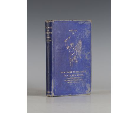
Lot 3215
MCMULLEN, R.T. Orion, or How I Came to Sail Alone in a 19-Ton Yacht. London: Charles Wilson, 1878. First edition, 8vo (181 x 118mm.) Engraved frontispiece, engraved vignette to title, 1 folding map. (Light browning and spotting, occasional minor soiling and worm damage.) Original pictorial cloth blocked in gilt (extremities bumped, scuffed and rubbed, some damp-staining). Together with two small-format photographs of McMullen's boat Orion. - And twelve other volumes including two others by R.T. McMullen. Provenance: The Michael Gilkes Collection (13).

Lot 3153
MEADE, Herbert. A Ride through the Disturbed District of New Zealand; together with some Account of the South Sea Islands. London: John Murray, 1870. 8vo (230 x 144mm.) 4 chromolithographed plates, 2 maps (1 folding), numerous illustrations, 32pp. publisher's advertisements at rear. (Folding map torn without loss, some soiling, occasional spotting or browning.) 20th Century morocco-backed cloth (spine faded and slightly rubbed).

Lot 3227
DALLAWAY, James, and Edmund CARTWRIGHT. A History of the Western Division of the County of Sussex. [Rape of Chichester and Rape of Bramber]. London: 1815-1830. Vol. I parts I & II, and Vol. II part II only, 2 vols., folio (348 x 249mm.) 3 folding genealogies, 3 maps (2 double-page) ?only, 24 plates (1 double-page) to vol. I; 24 engraved plates (1 double-page, 2 colour), 5 maps (3 colour, 2 folding), numerous hand-coloured illustrations to vol. II. (Some spotting and browning, 1 map torn without loss.) Contemporary morocco (rebacked, extremities scuffed and rubbed).

Lot 3177
GORDON, Pat. Geography Anatomiz'd: Or, the Geographical Grammar… the fourth edition corrected, and somewhat enlarged. London: S. and J. Sprint et al., 1704. 8vo (171 x 110mm.) Title in red and black, 16 double-page engraved maps. (Light browning, occasionally heavy, some light spotting, minor tear without loss to title, minor marginal tear without loss to map opposing p.78.) Contemporary calf, spine gilt in six compartments with raised bands (extremities bumped and scuffed, lettering piece to spine lacking, upper-cover detached, stitching weak). Provenance: Thomas Wentworth (signed and dated '1707' to front pastedown); William Charles de Meuron (armorial bookplate to front pastedown).
![HARDY, Thomas [Wessex Edition, The Works… in Prose and Verse.] London: Macmillan and Co., Limited, 1917-1926. 23 vols., 8vo (](https://cdn.globalauctionplatform.com/2803c591-4e16-4b23-9fb0-a68d0114e996/c27532e2-62ae-4a57-e4e3-185297892338/468x382.jpg)
Lot 3096
HARDY, Thomas [Wessex Edition, The Works… in Prose and Verse.] London: Macmillan and Co., Limited, 1917-1926. 23 vols., 8vo (220 x 139mm) Frontispieces, double-page map to rear of each volume. (Some spotting.) Contemporary brown half-calf, by H. Sotheran, spines gilt in six compartments with raised bands, morocco lettering pieces to the second and third compartments, the others with repeat decoration in gilt, t.e.g. (extremities occasionally lightly bumped and scuffed). Note: a further volume was published posthumously in 1931 but is not included within this set.

Lot 3226
SMITH, Charles. Smith's New General Atlas containing Distinct Maps of all the Principal Empires, Kingdoms, & States throughout the World. London: 1826. 4to (390 x 308mm.) Engraved title-page, engraved table and 55 hand-coloured engraved maps on 47 leaves, some double-page. (Somewhat affected by damp, some old damp-staining, title and some other leaves brittle with associated tears and loss, one map torn at fold without loss.) Contemporary half-calf (somewhat rubbed and scuffed).

Lot 3079
CERVÁNTES SAAVEDRA, Miguel de. El Ingenioso Hidalgo Don Quixote de la Mancha… nueva edicion. Madrid: Joachin Ibarra, 1782. 4 vols., 8vo (166 x 98mm.) 24 engraved plates only. (Light browning, some spotting and occasional soiling, lacking map.) Contemporary tree-calf, spines gilt (extremities lightly bumped and scuffed). Provenance: James Marsh (ink inscriptions to titles of all volumes, name to vol. I scratched out with associated thinning and holes to paper).
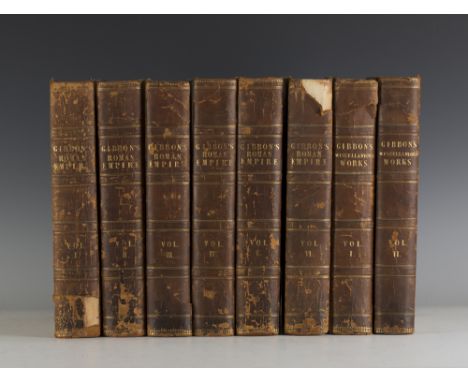
Lot 3244
GIBBON, Edward. The History of the Decline and Fall of the Roman Empire. London: W. Strahan and T. Cadell, 1776-1788. First edition, 6 vols., 4to (277 x 221mm.) Engraved portrait frontispiece and 2 folding maps to vol. II, folding map to vol. III. (Browning, heavy damp-staining throughout, some offsetting, minor spotting and soiling.) 19th Century half-calf (extremities bumped and scuffed, joints split, upper-cover and first few leaves of vol. I detached, upper-cover of vol. VI detached). - And two other volumes by Gibbon ('Miscellaneous Works'. London: 1796. 2 vols., 4to, bound to match) (8).
![[YOUNG, Arthur.] A Six Months Tour through the North of England… the second edition, corrected and enlarged. London: W. Strah](https://cdn.globalauctionplatform.com/2803c591-4e16-4b23-9fb0-a68d0114e996/60379bcf-2cd9-44b5-b177-00785612152e/468x382.jpg)
Lot 3069
[YOUNG, Arthur.] A Six Months Tour through the North of England… the second edition, corrected and enlarged. London: W. Strahan et al., 1771. 4 vols., 8vo (205 x 121mm.) 16 engraved plates, 13 folding engraved plates, 6 folding tables, 1 folding map. (Browning and spotting, some offsetting.) Contemporary calf (rebacked in 20th Century calf, extremities lightly bumped and scuffed).

Lot 3198
TOPOGRAPHY. - George W.T. OMOND. Belgium painted by Amédée Forestier. London: A. & C. Black, 1908. 8vo (220 x 150mm.) 77 colour plates, folding map at rear, 8pp. publisher's advertisements at rear. (Minor spotting to fore-edge.) Original decorated cloth (extremities lightly bumped). - And twenty-nine others of topographical interest, many published by Adam and Charles Black (30).

Lot 3156
ALEXANDER, James Edward. Sketches in Portugal, During the Civil War of 1834. London: James Cochrane and Co., 1835. Hand-coloured aquatint frontispiece, 1 engraved map. (Spotting, occasionally heavy, light browning, occasional minor soiling.) Contemporary cloth-backed boards (extremities bumped and scuffed, label to spine rubbed and browned). Provenance: Robin L. Marsh (bookplate to front pastedown); two further unidentified signatures to front-free endpaper.

Lot 3254
CARTOGRAPHY. - John GOSS. The Mapping of North America, Three Centuries of Map-making 1500-1860. New Jersey: The Wellfleet Press, 1990. Numerous colour plates (spotting to half-title.) Original cloth, spine gilt, dust-jacket (slightly soiled). - And a quantity of other volumes relating to cartography. Provenance: The Michael Gilkes Collection (a quantity).

Lot 3202
CASSELL, PETTER AND GALPIN (publishers). Cassell's General Atlas… of Countries of the World… Forming a Complete Atlas of Modern Geography. London: [n.d.] Folio (490 x 335mm.) 42 maps hand-coloured in outline, 17 double-page maps hand-coloured in outline, 2 folding maps hand-coloured in outline. (Light browning, occasional minor damp-staining, marginal tear without loss to folding map of the British Isles.) Contemporary cloth blocked in gilt and blind (extremities bumped and scuffed, spine and corners reinforced, chipped head and foot of spine). Provenance: Frances Louisa Swayne (armorial bookplate to front pastedown); Joseph Griffiths Swayne (label to front-free endpaper).
![RAILWAYS. British Railways Holiday Guide 1954, Area No.3 Eastern England. [N.p.:] British Railways, [n.d.]. 8vo (215 x 140mm.](https://cdn.globalauctionplatform.com/2803c591-4e16-4b23-9fb0-a68d0114e996/d820c518-16f2-4b05-d9bb-e66ce7ec1dea/468x382.jpg)
Lot 3047
RAILWAYS. British Railways Holiday Guide 1954, Area No.3 Eastern England. [N.p.:] British Railways, [n.d.]. 8vo (215 x 140mm.) Numerous illustrations and advertisements, folding map at rear. (Some browning.) Original pictorial wrappers (lightly creased, wrappers nearly detached). - And a quantity of others relating to railways (a quantity).
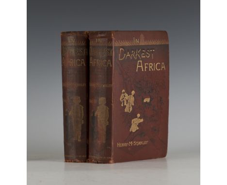
Lot 3046
STANLEY, Henry M. In Darkest Africa or the Quest Rescue and Retreat of Emin Governor of Equatoria. London: Sampson Low, Marston, Searle and Rivington Limited, 1890. First edition, 2 vols., 8vo (222 x 142mm.) Portrait frontispieces, three folding maps, numerous illustrations many full-page. (Some spotting and light browning, 1 map torn without loss.) Original cloth blocked in black and gilt (extremities bumped and chipped, slightly soiled). Provenance: S.A. Mead (inscription dated 2/7/90 to reverse of front-free endpaper).
![[CROMWELL, Thomas.] Excursions in the County of Sussex. London: 1822. 8vo (225 x 135mm.) Engraved frontispiece, engraved addi](https://cdn.globalauctionplatform.com/2803c591-4e16-4b23-9fb0-a68d0114e996/61395001-98f8-468d-aab4-d7f7f8174f37/468x382.jpg)
Lot 3072
[CROMWELL, Thomas.] Excursions in the County of Sussex. London: 1822. 8vo (225 x 135mm.) Engraved frontispiece, engraved additional decorative title, folding map and 44 engraved plates. (Some spotting.) Contemporary half-morocco, t.e.g. (lightly scuffed, spine slightly scuffed). - And one other volume of related interest (CARACCIOLI. The Antiquities of Arundel. London: 1766. 8vo) (2).
![NORDENSKJÖLD, Nils Otto, and [Johan] Gunnar ANDERSSON. Antarctica or Two Years Amongst the Ice of the South Pole. London: Hur](https://cdn.globalauctionplatform.com/2803c591-4e16-4b23-9fb0-a68d0114e996/54c5c878-a860-4c9a-8485-c8fed3d8d851/468x382.jpg)
Lot 3084
NORDENSKJÖLD, Nils Otto, and [Johan] Gunnar ANDERSSON. Antarctica or Two Years Amongst the Ice of the South Pole. London: Hurst and Blackett, Limited, 1905. First U.K. edition, 8vo (228 x 153mm.) Frontispiece, 4 colour plates, numerous uncoloured illustrations, 4 colour maps (3 folding). (Light browning and spotting, occasional soiling, 1 map slightly soiled and torn with minor loss, 1 map torn and repaired without loss.) Original green pictorial cloth, lettering to upper-cover blocked in gilt, spine gilt (extremities bumped and scuffed, covers soiled, spine darkened, lower joint splitting, stitching weak). Spence 860. - And one other by Nordenskjöld. Provenance: The Michael Gilkes Collection (2).

Lot 3049
COWPER, Frank. Sailing Tours: The Yachtsman's Guide to the Cruising Waters of the English Coast. London: L. Upcott Gill, [n.d. but circa 1892-1896.] 5 vols., 8vo (177 x 117mm.) 3 colour map frontispieces, 7 tinted plates, 116 colour maps, numerous advertisements. (Some browning and spotting, heavier spotting to vol. V, occasional minor soiling, 1 plate loosely inserted to vol. I.) Original pictorial cloth blocked in black and gilt (extremities bumped and scuffed, some minor soiling and stitching weak). Provenance: J.R. Howe (signature to front-free endpaper of vol. II); The Michael Gilkes Collection.

Lot 1130
A group of five Derby figures, circa 1770-90, comprising; a map seller raised on a scroll moulded base; a figure of a vintner carrying a barrel over one shoulder; two figures of children carrying baskets and a shepherdess seated before a flowering tree, (a.f), the tallest 16cm high. Provenance: The Rowland Williams Collection.

Lot 1411
WATNEY (V.J.) Cornbury and the Forest of Wychwood. (Limited Edition). 44 photogravure & other plates (with captioned guards), a folded map & plan, 3 folded genealogical tables, erratum slip; half morocco & buckram, gilt-lettered panelled spine, gilt top, thick impl. 8vo. privately printed, 1910. * homage to a house & estate (sometime home of the Hydes & Spencers); a sumptuous production. * Hampton Lodge (Hurstpierpoint) pictorial bookplate

Lot 1415
PULMAN (G.P.R.) The Book of the Axe . . . and historical sketches of all the parishes and remarkable places upon its banks . . . 4th edition, re-written and greatly enlarged. large folded map, 16 plates & num. text illus., advert leaf, gilt-pictorial cloth, thick roy. 8vo. 1875. * the best edition of a major Devonian title. Illustrated
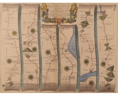
Lot 206
After John Ogilby, late 17th century strip map of The Continuation of ye Extended Road from Barnstable to Truro from the "Britannia" by John Ogilby, published in 1675 with later hand colouring . This map is Number 34 of 100 maps in the atlas and is entitled "The Continuation of ye Extended Road from Barnstable to Truro." From Hatherley to Ivy to Newport to Hall Drunkard to Cambleford to St. Indullion to Padstow to St. Colom to St. Michaell to Truro 35.5cm x 45.5cm, framed and glazed; together with a Robert Morden (fl. 1668 - 1703) Cornwall Map, possibly first edition c.1695 from Camden's Britannia, features a 'A Table of ye Explanation of ye figures in ye Map' and a further key with the note 'Here Note ye in all ye Maps Thefe Marks Signifie' and a list of symbols representing, towns villages, castles etc. 36.5cm x 43.5cm, framed and glazed (2) The Morden map trimmed to the plate marks and laid down


Lot 36
Selection of WWI & WWII paperwork and ephemera including registration certificate, ration tokens, souvenir of the occupation of Jerusalem by British troops 1917, a speech by Winston Churchill in the House of Commons August 20th 1940, Daily Express war map of the Pacific and Struwwelhitler A Nazi Storybook by Doktor Schrecklichkeit (QTY)


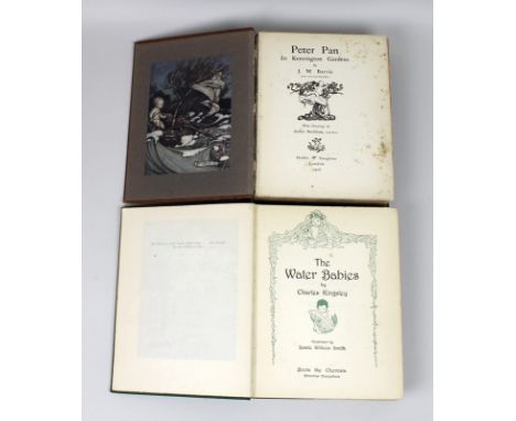
Lot 663
A first edition of J. M. Barrie's 'Peter Pan in Kensington Gardens illustrated by Arthur Rackham', Hodder and Stoughton, London 1906, London: Hodder and Stoughton, 1906, russet cloth with pictorial gilt design to upper and gilt titles to spine; grey end papers with map to flyleaf, complete with fifty mounted colour plates with captioned tissues bound at rear and frontispiece, 4to, some rubbing and wear to front cover, spine missing, some fly pages loose, foxing, dedication to title page dated Christmas 1906, together with a copy of 'The Water Babies' by Charles Kingsley, illustrated by Jessie Willcox Smith published by Boots the Chemist, no date but inscription to front cover dated 1929, gilt pictorial green cloth, 4vo, some foxing throughout. (2)

Lot 665
A group of Victorian and Edwardian books including 'Recollections of A Town Boy at Westminster 1849-1855, by Captain F Markham' published by Edward Arnold, London 1903, 8vo, gilt tooled calf, 'London to Ladysmith via Pretoria', by Winston Spencer Churchill, Published by Longmans, Green and Co, 1900, complete with folded map, 8vo, pictorial cloth boards and 'An Adventure' by Elizabeth Morison and Frances Lamont, published by Macmillan and Co, London 1911, gilt tooled blue cloth, 8vo. (5)


Lot 435
Numismatology - a Westminster 5 ounce silver proof coin commemorating the 2009 Gibraltar Henry VIII £10 coin with presentation case and certificate of authenticity, a white metal coin in the style of a Henry VIII groat and a Drake silver medallion / medal decorated with a map by Michael Mercator 1589 issued in a limited edition from the National Maritime Museum displayed in a presentation case (3)


-
109198 item(s)/page