We found 109182 price guide item(s) matching your search

Refine your search

Year

Filter by Price Range
  • List
  • Grid
  • 109182 item(s)
    /page

Lot 236

*Scotland. Morden (Robert), Scotland, [1695], uncoloured engraved map, 440 x 355 mm, mounted, framed and glazed, together with Greenwood (C. & J.), Map of the County of Warwick from an actual survey made in the year 1821, published 1830, engraved map with contemporary hand colouring, with the title and vignette with later hand colouring, additional horizontal fold, slight spotting and staining, slight creasing, torn with small area of loss, crudely repaired, 585 x690 mm, framed and glazed (2)

Lot 240

Somerset. Bowen (Emanuel), Somersetshire divided into hundreds..., circa 1767, engraved map with contemporary outline colouring, originally published in the 'Atlas Anglicanus', slight mount staining, lower margin partially trimmed and extended, 225 x 340 mm, together with Morden (Robert), Somersetshire, circa 1701, hand coloured engraved map, slight mount staining, old folds, 175 x 205 mm, with Wallis (J.), Somersetsh. [1812 - 1819], engraved map orientated to the north, contemporary outline colouring, supplied with a sheet of descriptive text, 135 x 95 mm, with another five county maps of Somerset, including examples by Darton, Lewis and Reid/Wallis, various sizes and condition (8)

Lot 241

South America. Senex (John), South America corrected from the observations comunicated to the Royal Societys of London & Paris, published C. & J. Bowles and Robert Sayer, circa 1760, engraved map with contemporary hand colouring, on two conjoined sheets, old folds, slight staining, 950 x 660 mm (1)

Lot 243

Spain & Portugal. Senex (John), A Correct Map of Spain & Portugal According to the newest Observations and Discoveries comunicated to the Royal Society at London and the Royal Academy at Paris, published J. & C. Bowles and Robert Sayer, circa 1760, large engraved map on two conjoined sheets with contemporary hand colouring, slight staining, 635 x 940 mm, together with A Map of old & new Castile from the observations of Rodgrigo Mendes Silva and others, [1710 or later], engraved map with contemporary hand colouring, 455 x 555 mm (2)

Lot 244

Straits of Dover. Fricx (Eugene Henri), Partie de L'Angleterre, Les Costes du Boulenois et le Pas de Calais [and] Carte particuliere des environs de Dunkerque, Bergues, Furnes, Gravelines, Calais et autres, published Brussels, 1707 -1709, four hand coloured engraved map sheets conjoined to show north west France and Belgium, the straits of Dover and east Kent, titles cut and pasted to margins, old folds, some strengthening to verso, overall size 850 x 1090 mm (1)

Lot 246

Switzerland & Austria. Visscher (Nicolas), Illustrissimis potentissimis ac florentissimis Rebus-Publicis Helvetiorum..., published Amsterdam, circa 1680, hand coloured engraved map, 470 x 470 mm, Latin text on verso, mounted, together with Seutter (George Matthaus), Principali dignitate gaudens comitat. Tirolis Episcopat tridentinum et Brixiensem..., published Augsburg, circa 1740, engraved map with contemporary hand colouring, central fold partially strengthened on verso, 490 x 575 mm, mounted (2)

Lot 247

Turkey. Senex (John), Turkey in Europe corrected from observations communicated to the Royal Societys at London and Paris, circa 1760, engraved map with contemporary hand colouring, some dust soiling, slight creasing, trimmed to neatline on one vertical margin, 965 x 670 mm (1)

Lot 248

*Virginia & Carolina. Homann (Johann Baptist), Virginia Marylandia et Carolina in Septentrionali Britannorum Industria excultae repraesentate, Nuremberg, circa 1720, engraved map with contemporary hand colouring, large ornate uncoloured cartouche, slight creasing, slight offsetting, 490 x 590 mm (1)

Lot 251

World. Coronelli (Vicenzo Maria), Primi Elemento o Introdutione Al Corso Geografico, published Venice, circa 1690, hand coloured double hemisphere chart, 460 x 600 mm, mounted An unusual map showing the climatic zones, latitudes and longitudes but no land masses. (1)

Lot 253

*World. Speed (John), A new and accurat Map of the World. Drawne according to ye truest Descriptions, latest Discoveries & best Observations yt have beene made by English or Strangers, published Thomas Bassett & Richard Chiswell, [1676], hand coloured engraved map of the world on a hemispheral projection, insular California, decorated with engraved vignettes of the four elements, portraits of eminent explorers and celestial diagrams, red-ruled on verso and recto, some staining to margins but not affecting image, one pinhole to image, central fold strengthened on verso, 400 x 525 mm, English text to verso, mounted, framed and double glazed R. W. Shirley. The Mapping of the World, no. 317. (1)

Lot 254

Yorkshire. Meisner (Daniel), Carcer nonnunquam firmum prougnaculum. Hull in Engellandt, circa 1638, uncoloured engraved city plan, 100 x 150 mm, together with Saxton (Christopher & Hole William), Eboracensis comitatus (Cuius incolae olim Brigantes appellabantur) pars Orientalis, vulgo East Riding, [1637], hand coloured engraved map, 195 x 250 mm, with Mercator (Gerard & Hondius Henricus), Eboracensis provincia, circa 1650, hand coloured engraved map, 165 x 205 mm, German text on verso (3)

Lot 255

Yorkshire. Blome (Richard), The North Ridinge of Yorkshire, A Mapp of ye East Rideing of Yorkshire [and] A Mapp of Richmond Shire being part of the North Rideing of York shire, cira 1673, together three hand coloured engraved maps, each approximately 245 x 290 mm, together with Moll (Herman), York Shire with the Post Roads &c, The West Riding of York Shire, The East Riding of York Shire [and] The North Riding of York Shire, [1724], together four hand coloured engraved maps with the borders decorated with antiquities, each approximately 195 x 320 mm, with Hutchinson (Thomas), A Correct Map of Yorkshire, A Map of the East Riding of Yorkshire, A Map of the North Riding of Yorkshire [and] A Map of the West Riding of Yorkshire, [1748], together four uncoloured engraved maps, each with a 'picture frame' cartouche, each approximately 150 x 170 mm (11)

Lot 258

Yorkshire. Hobson (William Colling), This Map of Yorkshire is most respectfully dedicated to the nobility, clergy, gentry, landowners and manufacturers of the county, 1843, large scale uncoloured engraved map on four sheets, engraved by J & C Walker, some repaired marginal closed tears, slight staining, each sheet approximately 630 x 790 mm, bound in contemporary blue paper wrappers with printed label to upper cover 'Part Third. Greenwood and Compys. Atlas of England and Wales' (1)

Lot 260

Yorkshire. Tuke (John), Map of the County of York, 1787, engraved map with contemporary hand colouring on four sheets conjoined to form two sheets, inset town plan of Kingston upon Hull, inset map of the county showing the Roman roads, large decorative uncoloured cartouche, compass rose and table of explanation, slight dust soiling and toning, trimmed to neatline with thread margins, old folds with slight creasing, overall size 1180 x 1420 mm (2)

Lot 261

Yorkshire. Speed (John). York Shire, published John Sudbury and G. Humble, [1610 or later], uncoloured engraved map, 385 x 510 mm, no text on verso (1)

Lot 262

Yorkshire. Smith (Charles). A New map of Yorkshire divided into Ridings &c. 3rd edition corrected to 1818, engraved map with contemporary outline colouring, printed on four sheets, not conjoined, slight offsetting, each sheet approximately 460 x 535 mm, together with, Teesdale (Henry), Yorkshire, [1831], engraved map with contemporary hand colouring, printed on four sheets, not conjoined, each approximately 355 x 425 mm, with Lewis (Samuel), Yorkshire, circa 1844, engraved map with contemporary outline colouring, old folds, 395 x 505 mm, plus Cruchley (G. F.), Cruchley's county map of Yorkshire showing all the railways & names of the stations, also the villages, turnpike roads, gentlemens seats &c. &c. published Gall & Inglis, circa 1875, lithographic map with contemporary hand colouring, slight spotting, slight marginal fraying, 490 x 550 mm, and Cary (John), A New Map of Yorkshire, divided into its Ridings and subdivided into hundreds exhibiting its roads, rivers, parks &c., 1808, engraved map with contemporary outline colouring on four sheets, not conjoined, slight offsetting, each sheet approximately 480 x 555 mm, with, Collins (H. G.), The British Gazetteer, Yorkshire, [1852], uncoloured lithographic map on four sheets, not conjoined, old folds, each sheet approximately 360 x 430 mm (18)

Lot 263

Ackermann (R., publisher). The Repository of Arts, Literature, Commerce, Manufacturers, Fashions and politics..., volume 6, 1811, volume 14, 1815 & volume 8 (third series), 1826, three volumes containing 107 engravings and aquatints, most with contemporary hand colouring and including three folding, comprising 1 map, 36 fashion plates, 18 furniture, 6 cloth samples, 28 British topographical views, 4 foreign views, and 14 miscellaneous, some offsetting, occasional toning and spotting, mixed contemporary bindings, two volumes with boards detached, one lacking spine, worn and rubbed, 8vo Sold as a collection of prints, not subject to return. (3)

Lot 27

Kerry-Nicholls (James Henry). The King Country; or, Explorations in New Zealand. A Narrative of 600 Miles of Travel through Maoriland, 1st edition, Sampson Low, Marston, Searle, & Rivington, 1884, frontispiece, text illustrations, folding map, library plate and related ink-stamps, original pictorial cloth gilt, small puncture to faded spine, slightly soiled overall, 8vo, together with Payton (Edward William), Round About New Zealand, being Notes from a Journal of Three Years' Wanderings in the Antipodes, 1st edition, Chapman and Hall, Limited, 1888, 20 plates including frontispiece, folding map (short closed tear), variable spotting, original pictorial cloth gilt, extremities rubbed, headcaps nicked, 8vo, plus Best (Elsdon), The Maori, 2 volumes, 1st edition, Wellington: Harry H. Tombs, Limited, 1924, illustrations to text, text-block slightly toned, original cloth, pale mottling, spines faded, 8vo, and approximately 40 others, 19th- and early-20th-century Australasian travel, some ex-library, including a copy of William Howitt's History of Discovery in Australia, Tasmania, and New Zealand (1st edition, 1865), 1 map only, 8vo (40)

Lot 292

*Portraits. A collection of thirteen French engraved portraits, mostly 17th & 18th century, thirteen uncoloured line engravings, including examples by Balechou, Drevet, Thomassin, St. Aubin, Salvador, Chereau, Dupuis, Grignon and Schuppen, various sizes and condition, one framed and glazed, together with two small British topographical engravings, a map of Liverpool by T. Starling and a stipple engraving by K. Mackenzie of a weeping child, all framed and glazed (17)

Lot 30

Kollmann (Paul). The Victoria Nyanza. The Land, the Races and their Customs with Specimens of some of the Dialects, 1st English edition, 1899, folding map, illustrations, a few light spots, endpapers a little toned, original red cloth gilt, spine faded, 8vo, together with Travel and Big Game, by Percy Selous and H.A. Bryden, 1st edition, 1897, six monochrome plates after Charles Whymper, top edge gilt, original green cloth gilt, slightly rubbed at spine ends, 8vo, plus Big Game Shooting in India, Burma and Somaliland, by Colonel V.M. Stockley, 1st edition, 1913, illustrations, advertisements at end, some light toning, hinges reinforced, original cloth, spine ends repaired, 8vo (3)

Lot 31

Krusinski (Judas Thaddaeus). The History of the Revolution of Persia, done into English, from the Original ... by Father du Cerceau, who has prefix'd a Map of Persia; and a Short History of the Sophies; with Curious Remarks on the Accounts given by Tavernier, Sir John Chardin, and Other Writers ... to which is added, a Short View of the Antient History of Persia ... not in the London Edition, 1st Dublin edition, printed by S. Powell, 1729, 2 volumes in 1, engraved folding map, woodcut head- and tailpieces, a few spots and marks, title page and first few gatherings damp-stained, modern calf, 8vo, together with Claustre (André de), The Compleat History of Thamas Kouli Kan, (Afterwards Shah Nadir), Late Sovereign of Persia ... written in French, and rendered into English, with Improvements, printed for J. Brindley [and others], [1750], engraved folding map coloured in outline, lacking portrait frontispiece, mild soiling, contemporary verse inscription to blank verso of final leaf, modern quarter calf, 12mo, plus Prideaux (Humphrey), The True Nature of Imposture fully display'd in the Life of Mahomet, 4th edition, corrected, 1708, final advertisement leaf, bookplate, contemporary panelled calf, rebacked, 8vo ESTC N7925, T77914, T138494. (3)

Lot 365

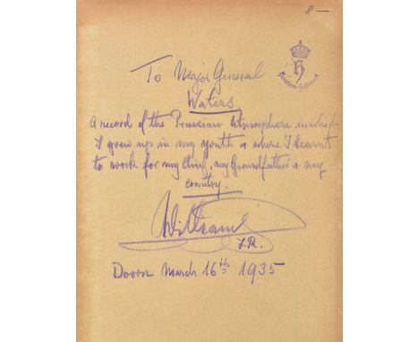
Wilhelm II (Kaiser). Collection of books inscribed to Brigadier Wallscourt Hely-Hutchinson Waters, 18 works in 19 volumes, published 1921-39, all inscribed by Wilhelm to Waters in black ink or purple pencil on front free endpapers, variously signed 'Emperor William', 'Kaiser William II', or 'William F. R.', and dated 1928-39, several works with Waters's significant annotations to endpapers and text(details below), original cloth, boards or wrappers, some soiling and wear, 8vo (one 4to), notable items include: presentation copies of 4 of Wilhelm's own books, i.e. 1) Vergleichende Geschichtstabellen von 1878 bis zum Kriegsausbruch 1914, 1st edition, Leipzig: K. F. Koehler, 1921, front inner hinge cracked, 2) Ereignisse und Gestalten 1878-1918, 1st edition, Leipzig: K. F. Koehler, 1922, 3) Meine Vorfahren, 1st edition, Berlin: Verlag für Kulturpolitik, 1929; 4) Das Wesen der Kultur, Leipzig: Offizin Haag-Drugulin, 1931, folding map in end-pocket; 5) Friedeburg (Friedrich von), Geschichte des Königlich Preussischen Ersten Garde-Regiments zu Fuss, 1871 bis 1914, 1st edition, [Potsdam], 1933, lengthily inscribed by Wilhelm 'To Major General Waters, a record of the Prussian atmosphere in which I grew up in my youth & where I learnt to work for my chief, my grandfather & my country, William, F. R., Doorn, March 16th 1935', with the ink-stamp of Kaiserin Hermine; 3 works annotated at length by Waters, i.e. 6) Chamberlain (Houston Stewart), Briefe 1882-1924 und Briefwechsel mit Kaiser Wilhelm II, 2 volumes, 1st edition, Munich: F. Bruckmann, 1928, annotated by Waters on front free endpaper of volume 2, recording Wilhelm's gift of the book and admiration for Chamberlain, 7) Müller-Brandenburg (Hermann), Die Schuld der Anderen und der Betrug von Versailles, 1st edition, Berlin: Schlieffen, 1931, Wilhelm's inscription and Waters's annotation both on front wrapper, and 8) Wölfel (Dominik Josef), So ist Spanien, Geheimgeschichte eines Bürgerkrieges, 1st edition, Leipzig: Karl Kühne, 1937, Waters's annotations include 'Overwhelming Jewish power in Spain (pp. 360 et seq.!) ... The Inquisition originally anti-Semitic only'; the 10 other inscribed items all in German and on similar subjects (interwar geopolitics, royal households, etc.); together with 12 similar books ex libris Waters, not inscribed by Wilhelm Collection of books providing a fascinating insight into Wilhelm II's intellectual life and one of his most significant friendships during his long exile. Wallscourt Hely-Hutchinson Waters (1855-1945) was British military attaché in Berlin from 1900 to 1903. He 'ingratiated himself [with Wilhelm II] by writing a letter of condolence when the Kaiserin died in 1921 and thereafter was frequently invited to be a guest at Doorn for extended periods of time. At the encouragement of his friend [American journalist Poultney] Bigelow, Waters wrote several volumes of memoirs, which were favourable to the Kaiser. To Wilhelm, this was very welcome' (Cecil, Wilhelm II: Volume 2, Emperor and Exile, 1900-1941, p. 322). (31)

Lot 415

Josephus (Flavius). The Genuine Works of Flavius Josephus, the Jewish Historian. Translated from the Original Greek, according to Havercamp's accurate Edition. Containing Twenty Books of the Jewish Antquities, with the Appendix, or Life of Josephus, written by himself: Seven Books of the Jewish War: and Two Books against Apion..., together with Proper Notes, Observations, Contents, Parallel Texts of Scripture, five compleat Indexes, and the true Chronology of the several Histories adjusted in the Margin..., with an Account of the Jewish Coins, Weights, and Measures. By William Whiston, M.A. some time Professor of the Mathematicks in the University of Cambridge, London: Printed by W. Bowyer for the Author, 1737, half-title, folding engraved map of Palestine and folding engraved plan of the Temples at Jerusalem, few decorative initials, head- & tail-pieces, occasional minor spotting, endpapers renewed, retaining ownership labels of David Barclay and Hudson Gurney, contemporary calf, morocco label to upper board, neatly rebacked and with morocco title label to spine, corners repaired, folio Large Paper Copy of this important English edition of the works of the first century Jewish historian. (1)

Lot 419

London. New Remarks of London: Or, A Survey of the Cities of London and Westminster, of Southwark and part of Middlesex and Surrey, printed for E. Midwinter, 1732, contemporary handwritten prayer in brown ink to front endpaper and recto of frontispiece, contemporary panelled calf, heavily rubbed, later bookplate of C.H. Waterland Mander to front pastedown, 12mo, together with Xenophon. Xenophon's History of the Affairs of Greece. By the translator of Thucydides, printed for Benjamin White, 1770, folding engraved map, bookplate of William Leake to front endpaper, contemporary full tree calf, gilt decorated spine, rubbed and joints cracked with a little wear, 4to, plus other various antiquarian interest, mainly 19th century, but including Briseux, L'Art de Batir des Maisons de Campagne, volume 1 only, Paris, 1761 (with numerous double-page engraved plates), a bound volume containing The Country Housewifes Garden, 1626, 24 pages, bound with The Art of Propogating Plants by Simon Harward, 10 pages, The Husband-Mans Fruitfull Orchard, 6 pages only, with further pages supplied in facsimile, Henry Mayhew, London Labour and the London Poor, 3 volumes bound in one, circa 1864, etc. (approx. 50)

Lot 42

McCombie (Thomas). The History of the Colony of Victoria, from its settlements to the death of Sir Charles Hotham, 1st edition, Melbourne and Sydney, 1858, a little light spotting and toning, original blindstamped cloth, tears and chips at spine ends, lightly rubbed, 8vo, together with The Rise and Progress of Australia, Tasmania, and New Zealand, by Daniel Puseley, 4th edition, 1858, advertisements bound before title, light toning, two leaves detached at front, hinges tender, original cloth, spine rubbed and darkened and torn at head, 8vo, plus The New Colony of Victoria, formerly Port Phillip: Together with some account of the other Australian Colonies, by John Fitzgerald Leslie Foster, 1st edition, 1851, a little light soiling, original cloth, spine browned with small tears, a few stains, 8vo, with others related including John Dunmore Lang's An Historical and Statistical Account of New South Wales, 2 volumes, 3rd edition, 1840 (lacking map), and P. Just's Australia; or notes taken during a residence in the Colonies from the gold discovery in 1851 till 1857, Dundee 1859 (ex libis, lacking rear endpaper) (9)

Lot 423

Newcourt (Richard). Repertorium Ecclesiasticum Parochiale Londinense: An Ecclesiastical Parochial History of the Diocese of London..., 2 volumes, 1708, engraved portrait frontispiece, four plates (including 3 folding) and one folding map, some toning and occasional spotting, contemporary calf, old reback, contrasting morocco labels, joints cracked and upper board of volume 1 loose, folio, together with Sewel (William), The History of the Rise, Increase, and Progress of the Christian People called Quakers, Intermixed with several Remarkable Occurrences..., now revis'd and publish'd, with some amendments, 1722, ownership inscription at head of title, light worming to lower blank margins at front of volume, dampstaining to first & last few leaves, contemporary calf, worn, folio, plus other 17th & 18th century theology related, including a defective 1609 edition of John Jewel's Works, all folio (7)

Lot 430

Qur'an [English] The Koran, commonly called the Alcoran of Mohammed, translated into English immediately from the Original Arabic; with Explanatory Notes, taken from the most Approved Commentators, to which is prefixed a Preliminary Discourse, by George Sale, 2 volumes, London, 1754, title pages printed in red and black, engraved folding map of Arabia, 2 folding geneaologies, 1 folding plate containing a plan and view of the Masjid al-Haram, short closed tear to inner margin of map, genealogies and plate slightly browned and rumpled along edges, plate with shallow chip along top edge not touching image, contemporary sprinkled calf, volume numbers gilt to spines, gilt frames to sides, minor loss to headcaps, volume 2 joints split but firm, 8vo ESTC T143522. First octavo edition and the second overall of Sale's Qur'an, reputedly the first English translation to be made directly from the Arabic. (2)

Lot 437

Selden (John). Mare Clausum sev de Dominio Maris Libri Duo, 2 parts in one, London: William Stanesbeii pro Richardo Meighen, [Leiden: Elzevir], 1636, title printed in red & black with Elzevir woodcut device, two folding engraved maps, two woodcut illustrations, folding map of England & Wales with four small holes to central fold where previously bound-in, occasional light spotting and soiling, previous owner blindstamp to front endpaper verso, circular bookplate, early 18th century mottled calf, spine vertically split, rubbed with wear to lower corners, 12mo STC 22175.3; Willems 449. (1)

Lot 442

Simeoni (Gabriele). Dialogo Pio et Speculativo, con diverse sentenze, Latine & volgari, di M. Gabriel Symeoni Fiorentino, Lyon, Guillaume Rouillé, 1560, title with printer's woodcut device, 18th century English ownership signature to head of title (not legible), and contemporary Italian ownership inscription to foot of title 'Di Donato Rofia... Sua 1569 a Cesena', numerous woodcut illustrations of coins and monuments, folding woodcut map of the Limagne in the Auvergne, errata and colophon to verso of final leaf, some spotting to first and last few leaves, and light browning at front of volume, without final blank, old diced calf, rebacked with majority of original spine laid down, rubbed and a little wear to edges, 4to Mortimer Harvard University French Books 498. First edition. Gabriele Simeoni (1509-1575) author of a number of historical tracts, emblem books, settled in Lyon, where he became a member of the scholarly circle around Maurice Sceve and Guillaume du Choul. (1)

Lot 559

MAP OF SEFTON, NEEDLEWORK PICTURE AND A MIRROR

Lot 683

ENGRAVING OF OLD SHAWS BROW IN 1852 AND A MAP OF CHESHIRE

Lot 307

Sale Item: FRAMED MAP ROSS & CROMARTY & LEWIS (AF) Vat Status: No Vat Buyers Premium: This lot is subject to a Buyers Premium of 15% + Vat @ 20% Additional Info : Lots purchased online with the-saleroom.com will attract an additional charge for this service in the sum of 3% of the hammer price plus VAT @ 20%

Lot 366

Sale Item: FRAMED MAP ARRAN TIMOTHY PONT (AF) Vat Status: No Vat Buyers Premium: This lot is subject to a Buyers Premium of 15% + Vat @ 20% Additional Info : Lots purchased online with the-saleroom.com will attract an additional charge for this service in the sum of 3% of the hammer price plus VAT @ 20%

Lot 367

Sale Item: FRAMED MAP JURA T PONT (AF) Vat Status: No Vat Buyers Premium: This lot is subject to a Buyers Premium of 15% + Vat @ 20% Additional Info : Lots purchased online with the-saleroom.com will attract an additional charge for this service in the sum of 3% of the hammer price plus VAT @ 20%

Lot 368

Sale Item: FRAMED MAP NORFOLK R MORDEN (AF) Vat Status: No Vat Buyers Premium: This lot is subject to a Buyers Premium of 15% + Vat @ 20% Additional Info : Lots purchased online with the-saleroom.com will attract an additional charge for this service in the sum of 3% of the hammer price plus VAT @ 20%

Lot 369

Sale Item: FRAMED MAP SUSSEX (SVSSEXIA) Vat Status: No Vat Buyers Premium: This lot is subject to a Buyers Premium of 15% + Vat @ 20% Additional Info : Lots purchased online with the-saleroom.com will attract an additional charge for this service in the sum of 3% of the hammer price plus VAT @ 20%

Lot 590

Sale Item: FRAMED MAP ISLE OF MULL Vat Status: No Vat Buyers Premium: This lot is subject to a Buyers Premium of 15% + Vat @ 20% Additional Info : Lots purchased online with the-saleroom.com will attract an additional charge for this service in the sum of 3% of the hammer price plus VAT @ 20%

Lot 608

Sale Item: FRAMED MAP GLENELG BAY & SEA CHART BUCKIE TO FRASERBURGH Vat Status: No Vat Buyers Premium: This lot is subject to a Buyers Premium of 15% + Vat @ 20% Additional Info : Lots purchased online with the-saleroom.com will attract an additional charge for this service in the sum of 3% of the hammer price plus VAT @ 20%

Lot 733

Sale Item: FORT WILLIAM STANLEY HARBOUR MAP Vat Status: No Vat Buyers Premium: This lot is subject to a Buyers Premium of 15% + Vat @ 20% Additional Info : Lots purchased online with the-saleroom.com will attract an additional charge for this service in the sum of 3% of the hammer price plus VAT @ 20%

Lot 1132

An Action Man flock hair Colditz Escape Officer with map and case:, together with a flock hair Military Police Officer (2)

Lot 590

Various artist signed prints, to include Sonia Bramma, Belinda King, map of East Riding of Yorkshire etc.

Lot 349

BLAEU; a 17th Century hand coloured map "Portugallia et Algarbia". 15" (38cms) x 20" (51cms).

Lot 471

A John Speede coloured map of Suffolk, divided into hundreds, 38cm x 51cm

Lot 273

Small group of vintage maps to include: Bacon's Cycling Road Map of England and Wales; Bacon's Cycling and Motoring Map of Salisbury and District; The New Official RAC Touring Map of England and Wales (popular edition); Bacon's Motoring and Cycling Road Map 50 miles around Bristol; Ordinance Survey Map sheet 108 Epping, Enfield and Brentwood; Ordinance Survey Tourist Map of Chichester, together with a Motor Fuel Ration Book for a motorcycle not exceeding 250cc, together with two albums of cigarette type cards by Mobil Fuels 'The Great Days of Motoring'. (9)(B.P. 24% incl. VAT)

Lot 402

Robert Morden, (British, flourished from 1650 -1703), 'South Wales' and 'North Wales', two sparsely coloured maps of the Principality, 37 x 45cm approx. (2)(B.P. 24% incl. VAT) CONDITION REPORT: Hogarth framed, the map of South Wales has some discolouring, North Wales rather better, North Wales with distinct crease to top right hand corner.

Lot 1413

A MAHOGANY FRAMED COFFEE TABLE, with a world map to the top and brass banding, approximate size width 89cm x depth 61cm x height 41cm

Lot 894

EPHEMERA, selection, inc. prints (2) Baalbec, Temple called El Knasne Petra, both overmounted, watermarks on mount 21.5 x 27.5; b/w photographs of locomotives (7) laid down to board; oil paintings on board (2) waterfall, boat on a lake 12.5 x 26.5; Hedges & Butler Ltd. L'Amour du Gout et le Gout de L'Amour calendar; posters inc. advertising war savings certificates, war map of the Russian front, LNER, map of electrification of Sydlige Norges, canvas map of London etc., 33 x 41 and smaller, G to EX, 17

Lot 896

EPHEMERA, selection, inc. The Fantastic Voyage colour lobby cards; 1938 London underground railway map; 1907 ordnance survey map of Bucks Leighton Buzzard and Luton; sheet music for The Whiffenpoof Song; 1923 The Dominion of New Zealand handbook; Parkinsons Recipes and Home Hints leaflet; The Story of King Edward VIII told in pictures with abdication message; Manchester Tramways headed letter signed by Henry Mattinson (general manager) laid down to board; war leaflets, inc. Queensberry Club concert programme feat. American A.E.F Band conducted by Glenn Miller (second last performance); advertising film posters (12) inc. Jane Eyre, Jude, Larger than Life, Little Women, Much Ado About Nothing, Leo the Last, Long Live the Lady etc. all 40 x 30; FR to VG, 29*

Lot 949

LEVER BROS., Sectional Map of England & Wales, complete, G to VG, 30

Lot 990

MIXED, complete & part sets, inc. Sinclair Dogs, Cadbury Famous Steamships, Kane, Lyons, Hustler, Primrose Popeye & Flinstones, Churchmans Sectional Cycling Map, Home & Colonial, Mister Softee etc., G to EX, Qty.

Lot 164

Four 18th Century hand coloured maps, extracted from Pattersons British ItineraryPrinted Carrington Bowls 1895, map no's. 99, 100, 101, 102, 111, 112, 113 and 114, together with a further coloured map of Cheshire after L Cary, largest 17x8.5cm, contemporary gilt frames.

Lot 164A

A mixed lot of Antique coloured mapsComprising The Road from London to Hollyhead, Stockdale map of the canal from Manchester to Runcorn published 1795, Dawson map of Kingston upon Hull, John Ogilby The Road from Cambridge to Coventry and a further Heraldic crest print, various sizes (5)

Lot 500

Boxed Seth Thomas lady's wristwatch and strap, a boxed map measuring tool, a multi-function pocket knife and a small quantity of costume jewellery

Lot 197C

Antique framed map of North Wales, engraver J Cary, published by John Stockdale 1805

Lot 489

WRIGHT, Thomas: The History and Topography of the County of Essex Illustrated by a Series of Views Taken on the Spot by Messrs G Arnold, Bartlett, Campion, &c. 2 Volumes. G. Virtue, 1836. V.1- ½ title, extra engraved title with vignette (dated 1842), iv, viii (list of subscribers), 696, + hand coloured Map and 35 plates; V.2- Frontis, extra engraved title with vignette (dated 1831), title, 836, + 64 plates; in all coloured map, two vignettes and 100 plates. Contemporary half leather; covers rubbed; occasional foxing and browning. (2)

Lot 579

A Robert Morden hand coloured map of Essex

Lot 394

Eight pictures and prints, to include a map of Newmarket, (8)

Lot 154

17TH CENTURY R.SPOFFORTH NEW MAP OF SPAIN & PORTUGAL

Lot 164

SAXTON MAP OF NORTHAMPTONSHIRE & 3 PRINTS

Lot 147

A printed map of Kent, together with a printed map of Sussex, 38 x 50cm, (2)

Loading...Loading...
  • 109182 item(s)
    /page

Recently Viewed Lots