We found 109182 price guide item(s) matching your search
There are 109182 lots that match your search criteria. Subscribe now to get instant access to the full price guide service.
Click here to subscribe- List
- Grid
-
109182 item(s)/page


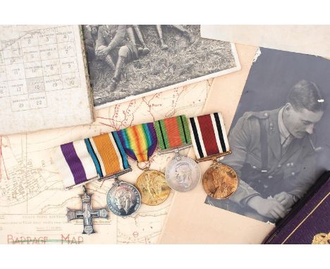
Lot 383
FIRST AND SECOND WAR RFA MILITARY CROSS GROUP OF FIVE AND ARCHIVE TO CAPTAIN N. S. KINNERSLEY, comprising Military Cross, British War Medal, Victory Medal, Defence Medal and Special Constabulary Medal, together with MC box of issue, miniature group, British Legion badge, ARP badges, note book, various range tables and drill pamphlets, engineer's plans for two various Frist Army concrete or Pill Boxes, embarkation orders, citation etc, ARP, studio and unit photographs, 1916 dated Somme trench and sector fire map, dozen or more further trench maps, barrage maps, Field Service Regulations, Wellington's Men, a quantity of Postcards, his sword and various shell cases. Citation reads - For conspicuous gallantry and devotion to duty in keeping the enemy at bay for a considerable time by laying over open sights whilst subjected to heavy rifle and machine gun fire. He succeeded in evacuating the wounded before retiring and passed through valuable information from time to time.


Lot 378
TALISKER TRI-PACK 3X20CL Single Malt Scotch Whisky Includes Talisker aged 18 years (45.8%), Talisker 1993 Distillers Edition (45.8%), and Talisker 10 years old (45.8%). All 20cl in box. TALISKER 10 YEARS OLD MAP LABEL 20CL Single Malt Scotch Whisky 20cl, 45.8% volume, in carton. Four 20cl bottles.


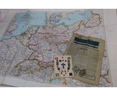
Lot 515
A Collection Of Militaria To Include : A Royal Artillery Corps Cap Badge, A Royal Tank Corps Cap Badge, A Copy Of The Blue Flash Newspaper Dated 5th April 1946 (The Newspaper Of The 4th Royal Tank Corps), A 1945 Second Army Thanksgiving Service Book And A 1953 Dated Map Of Germany Showing The New Agreed Zone Borders.


Lot 391
A large continental silver bookmark / letter-opener, the terminal relief decorated with signs of the zodiac with a map of the world to the opposing side, the stem engraved Thorflam 1976 - MTS Benelux 1996, length 17.5cm; together with a continental white metal bookmark / letter-opener, the terminal in the form of a fleur de lis; and various other bookmarks (10)


Lot 269
Action Man, Palitoy and others - A large collection of loose vintage Action Man accessories in a scratch built wooden box measuring approx (H40cm x W50cm x D8cm) containing in excess of 100 items including map cases, detonators, gas masks, pistols, daggers, canteens and similar. All items are in playworn condition.

Lot 1598
Plots Natural History of Staffordshire - Robert Plot: Natural History of Staffordshire, printed at the Theatre, Oxford, 1686. Full Calf, 450pp plus index Thirty six of thirty seven plates, 15 missing from page 222, lacks the map. Robert Plot was the first Keeper of the Ashmolean Museum and Profesor of 'Chymistry' at the University of Oxford. He was born in Borden, Kent and is buried there. Size: 325mm x 205mm appx.


![[CHILDRENS] Milne, A.A. The House at Pooh Corner, first edition, Methuen, London, 1928, slate blue leather gilt, pink pictor](https://cdn.globalauctionplatform.com/f863d30b-b331-4d8c-8791-aaf600a3ea57/d189ca7f-7b35-4ec9-bfad-aaf8016bcdd4/468x382.jpg)
Lot 683
[CHILDRENS] Milne, A.A. The House at Pooh Corner, first edition, Methuen, London, 1928, slate blue leather gilt, pink pictorial silhouette endpapers, all edges gilt, illustrations by Ernest Shepard, octavo (spine with losses and wear at ends; upper cover with some fading; bookplates to front free endpaper verso and title page); and Milne, A.A. Winnie-the-Pooh, second edition, Methuen, London, 1926, dark green cloth (slightly crinkled), pale green map endpapers, top edges gilt, illustrations by Ernest Shepard, octavo (bookplate to second endpaper recto), (2).
![[TRAVEL]. AFRICA Stanley, Henry M. In Darkest Africa, or The Quest, Rescue and Retreat of Emin, Governor of Equatoria, first](https://cdn.globalauctionplatform.com/f863d30b-b331-4d8c-8791-aaf600a3ea57/d6511690-8ba2-46e4-a3f5-aaf8016c82ef/468x382.jpg)
Lot 731
[TRAVEL]. AFRICA Stanley, Henry M. In Darkest Africa, or The Quest, Rescue and Retreat of Emin, Governor of Equatoria, first edition, two volumes, Sampson Low, Marston, Searle and Rivington, London, 1890, pictorial brown cloth gilt (hinges worn), plate and text illustrations, maps (large folding map in Vol.1 torn with significant loss), octavo.
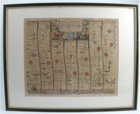
![[MAPS]. Ogilby, John (1600-1676). 'The Road from Dartmouth... to Minhead [Minehead]', engraved ribbon map, hand-coloured, 37](https://cdn.globalauctionplatform.com/f863d30b-b331-4d8c-8791-aaf600a3ea57/75d3bea9-b630-4ecc-a04f-aaf8016d1ed8/468x382.jpg)
![[MAPS]. Ogilby, John (1600-1676). 'The Road from London to St. Neotts... continued to Oakeham', engraved ribbon map, hand-co](https://cdn.globalauctionplatform.com/f863d30b-b331-4d8c-8791-aaf600a3ea57/33a609cc-886d-4191-b3af-aaf8016d2dcb/468x382.jpg)
![[MAPS]. Ogilby, John (1600-1676). 'The Road from Exeter to Truroe', engraved ribbon map, hand-coloured, 38.5cm x 49cm, frame](https://cdn.globalauctionplatform.com/f863d30b-b331-4d8c-8791-aaf600a3ea57/da19cbe5-ef7b-4676-bb3b-aafd009e61df/468x382.jpg)
![[MAPS]. CARDIGANSHIRE Speed, John (1552-1629), 'Cardigan Shyre', engraved map, sold by John Sudbury and George Humbell, hand](https://cdn.globalauctionplatform.com/f863d30b-b331-4d8c-8791-aaf600a3ea57/794a30d5-de47-463f-8e1a-aaf8016d3a56/468x382.jpg)
![[MAPS]. ENGLAND & WALES Kitchin, Thomas (1718-1784). 'An Accurate Map of England and Wales', engraved map, hand-coloured](https://cdn.globalauctionplatform.com/f863d30b-b331-4d8c-8791-aaf600a3ea57/853616df-4ec7-41b4-8cf4-aaf8016d4753/468x382.jpg)
![[MAPS]. ENGLAND & WALES Seale, Richard William (fl.1732-1775). 'A Map of England Wales', engraved map, hand-coloured in](https://cdn.globalauctionplatform.com/f863d30b-b331-4d8c-8791-aaf600a3ea57/77b42e70-e064-464e-b3c1-aaf8016d5711/468x382.jpg)
-
109182 item(s)/page