We found 108737 price guide item(s) matching your search
There are 108737 lots that match your search criteria. Subscribe now to get instant access to the full price guide service.
Click here to subscribe- List
- Grid
-
108737 item(s)/page

Lot 102
Vintage Union, Canada tinplate lunch box, cod bottle, cased christening set, Alum Bay glass paperweight, millefiori paperweight, rolled gold Parker ballpoint pen, Parker 61 fountain pen and ballpoint pens, model coracle, another model boat, album of matchbox tops, John Player cigarette cards, Cycling 1839-1939, folded map of the Great Western Railway, Japanese an Pakistan banknotes, playing cards and collectors plates mainly Steam Trains and War Ships


Lot 9
Ashmor Fine China for 'History in Porcelain' limited edition figure of Field Marshall The Viscount Montgomery of Alamein, standing on stones with a campaign map on his leg, numbered 26 of 375, with Certificate of Authenticity and box, 29 cm highCondition Report: Good condition, with no damage found. includes certificate, box and sleeve


Lot 156
° ° Demidoff, E. After Wild Sheep in the Altai and Mongolia. With 82 a Coloured Frontispiece and a Map. Roland Ward, London, 1900. Folding map bound at the back. Remainder(?) cloth binding, slightly warped. Together with, Ward, Rowland [Edited by Dollman, Guy and Burlace, J. B.] Rowland Ward’s records of Big Game African and Asian Sections … Tenth edition 1935. Original, rubbed cloth binding. * Inscribed by Malcolm Lyell on the front free endpaper with some note by him in the text. Some papers loosely inserted including three original photographs by [Lord] Arthur Murray tipped onto backing paper with ink descriptions in his hand. (2). Malcolm Lyell (1922-2011) a good shot, a fisherman, a naturalist, a gardener, a hunter, an adventurer, and a raconteur who has been described as having been the doyen of the London gun trade.After being educated at Bryanston and Westminster School, he took a degree in forestry at Bangor University in 1943 and worked as a forester until 1947 when he became the manager of Westley Richards London showrooms.In 1955 when the parent company made the decision to close the London showrooms, Malcolm sought the backing of British and American sportsmen to finance his takeover of the business and established Westley Richards (Agency). Soon after acquiring it he bought Jeffery’s the gun-makers, and later Farlow’s, the fishing tackle specialists.The ultimate salesman, he not only had a comprehensive knowledge but also loved and was proud of what he was offering for sale. Over the next twelve years he developed, expanded, and advanced the business with great panache and the able assistance of his wife Rosamunde (they married in 1949).His success brought its own reward, in 1959 Holland and Holland invited him to merge his company with theirs and he became the managing director of the new enterprise. By the time of his retirement in 1988, he had acquired a plethora of clients many of whom became great friends; they included kings and princes, maharajahs, presidents, and prime ministers. Hollywood stars, white hunters, sportsmen and trophy collectors fell under his spell and with Rosamunde and his two daughters Caroline and Harmony he travelled the world combining business with pleasure.Malcolm was born a collector, as a boy he collected objects to exhibit and opened his own “museum” in his parents’ house in South Kensington (admission to it cost the viewer one penny). Throughout his life his own houses became filled with treasures gathered from across the globe.His passion and the intense enjoyment that he derived from his collection can be seen in the ephemera and the considered personal notes and annotations that he added to most of his books.
![Reed, Stanley. [Ed.] The Indian Year Book. 1914. A Statistical and Historical Annual of the Indian Empire with an Explanation](https://cdn.globalauctionplatform.com/b9568e96-802b-4f45-99cf-ae6900b0990d/f23d2a78-2de1-41f1-9be2-ae6900b2f2b9/468x382.jpg)
Lot 169
Reed, Stanley. [Ed.] The Indian Year Book. 1914. A Statistical and Historical Annual of the Indian Empire with an Explanation of the Principal Topics of the Day. Bombay, 1914. Coloured folding map. Modern Quarter red leather binding, original spine tipped in. Burke, W. S. [Compiler}. The Indian Field Shikar Book. Third edition. Oblong octavo, 1906. Unused “Big Game Register” in pocket inside back cover. Front hinge broken. Original green cloth binding, worn. Together with a tired, incomplete, copy of Duke’s “Kashmir Handbook’, 1903. (3).Malcolm Lyell (1922-2011) a good shot, a fisherman, a naturalist, a gardener, a hunter, an adventurer, and a raconteur who has been described as having been the doyen of the London gun trade.After being educated at Bryanston and Westminster School, he took a degree in forestry at Bangor University in 1943 and worked as a forester until 1947 when he became the manager of Westley Richards London showrooms.In 1955 when the parent company made the decision to close the London showrooms, Malcolm sought the backing of British and American sportsmen to finance his takeover of the business and established Westley Richards (Agency). Soon after acquiring it he bought Jeffery’s the gun-makers, and later Farlow’s, the fishing tackle specialists.The ultimate salesman, he not only had a comprehensive knowledge but also loved and was proud of what he was offering for sale. Over the next twelve years he developed, expanded, and advanced the business with great panache and the able assistance of his wife Rosamunde (they married in 1949).His success brought its own reward, in 1959 Holland and Holland invited him to merge his company with theirs and he became the managing director of the new enterprise. By the time of his retirement in 1988, he had acquired a plethora of clients many of whom became great friends; they included kings and princes, maharajahs, presidents, and prime ministers. Hollywood stars, white hunters, sportsmen and trophy collectors fell under his spell and with Rosamunde and his two daughters Caroline and Harmony he travelled the world combining business with pleasure.Malcolm was born a collector, as a boy he collected objects to exhibit and opened his own “museum” in his parents’ house in South Kensington (admission to it cost the viewer one penny). Throughout his life his own houses became filled with treasures gathered from across the globe.His passion and the intense enjoyment that he derived from his collection can be seen in the ephemera and the considered personal notes and annotations that he added to most of his books.

Lot 248
Pictures - prints, reproduction map of Manchester; frames; etc** We would please ask that all payments are made by 12pm on Thursday 14th April at the latest. Collection for all lots is strictly by appointment at Otterbeck Hall, Chinley, SK23 6AH where all items are located. We request that items are collected on either Wednesday 13th or Thursday 14th April when Bamfords staff will be in attendance. In circumstances where buyers are unable to attend on these days members of the Stoodley family have kindly agreed to be present from Friday 15th to Monday 18th April at 12pm, however all lots must have been paid for by Thursday 14th April. It should be noted that keys will be handed to the new owners of Otterbeck Hall on Tuesday 19th April at which point Bamfords will no longer have access to the property. Bamfords are able, strictly by prior arrangement to bring certain higher value small items to the saleroom for collection at a later date. Please enquire and confirm this availability in relation to any lot that you are hoping Bamfords will be able to move on your behalf. Any such lot will incur a £15 charge**
Lot 55
Robert Morden, two page map, Darbyshire (sic), sold by Abel Swale, Awnfham (sic) and John Churchill, London (c.1722) hand coloured engraving, 36cm x 41cm** We would please ask that all payments are made by 12pm on Thursday 14th April at the latest. Collection for all lots is strictly by appointment at Otterbeck Hall, Chinley, SK23 6AH where all items are located. We request that items are collected on either Wednesday 13th or Thursday 14th April when Bamfords staff will be in attendance. In circumstances where buyers are unable to attend on these days members of the Stoodley family have kindly agreed to be present from Friday 15th to Monday 18th April at 12pm, however all lots must have been paid for by Thursday 14th April. It should be noted that keys will be handed to the new owners of Otterbeck Hall on Tuesday 19th April at which point Bamfords will no longer have access to the property. Bamfords are able, strictly by prior arrangement to bring certain higher value small items to the saleroom for collection at a later date. Please enquire and confirm this availability in relation to any lot that you are hoping Bamfords will be able to move on your behalf. Any such lot will incur a £15 charge**


Lot 195
A George III silk-embroidered map sampler,c.1785, depicting the east and west hemispheres, the four corners decorated with depictions of the peoples of Europe, Asia, Africa and America,47 x 80cmCondition report: Poor condition, the silk browned overall, areas perished and with other signs of staining and degradation. Not inspected out of frame.


Lot 328
Holland (Henry) - Travels in the Ionian Isles Albania Thessaly Macedonia...during the Years 1812 and 1813, map and plates, contemporary half calf, spine lettered gilt, engraved bookplate, 4to, London: Longmann, Hurst, Rees, Orme and Brown, 1815 and Edward Daniel Clarke - Travels in Various Countries of Europe, Asia and Africa, third edition, Part the First [only] Prussia Tartary and Turkey, plates and folding maps, contemporary half calf uniform with the first, 1813 (2)

Lot 370
Heber (Reginald) - Bishop of Calcutta: Narrative of a Journey Through the Upper Provinces of India from Calcutta to Bombay 1824-1825 with Notes upon Ceylon..., two volumes, folding map, hand coloured in outline, frontispieces, plates and engravings in the text, contemporary calf ruled gilt, spine with two green tickets, 4to, London: Murray, 1828 (2)

Lot 373
Waddington (George) - A Visit to Greece in 1823 and 1824, first edition, folding map and plan, contemporary calf, spine with red label, 8vo, London: Murray, 1825, Samuel Laing - A Tour in Sweden in 1838, contemporary calf, London 1839, Thomas Raffles - Letters During a Tour Through Some Parts of France Savoy Switzerland Germany and the Netherlands in the Summer of 1817, second edition, contemporary half calf, Liverpool 1819 and A de Stael-Holstein - Lettres sur d'Angleterre, contemporary patterned calf, Paris 1825 (4)
Lot 401
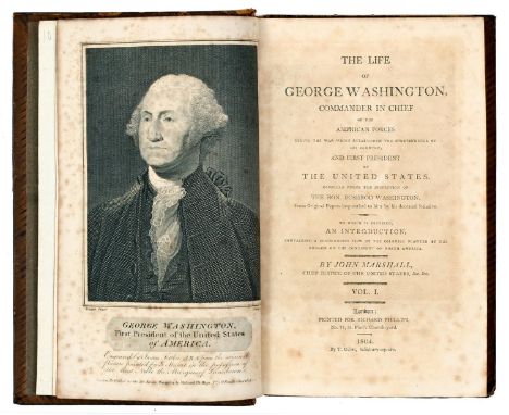
Marshall (John) - The Life of George Washington Commander-in-Chief of the American Forces During the War Which Established the Independence of his Country and First President of the United States, four volumes, engraved portrait, folding map and plates, contemporary diced calf ruled gilt, spine gilt by Mackey, Manchester, portrait and first few leaves of vol I browned, 8vo, London: Phillips, 1804 and 1805 and Memoirs, Correspondence and Private Papers of Thomas Jefferson late President of the United States, four volumes, engraved portrait frontispiece, facsimile letters at end of vol I, contemporary calf, engraved bookplate, London: Colburn and Bentley, 1829 (8)


Lot 1
The next 46 lots are all from a private Somerset map collection. A complete detailed list is available on request. 1- Blome: Somerset, A Mapp of the county. 1673-1677. (330x243), hand coloured & mounted; 2- Badeslade & Toms: Somersetshire, A Map of. 1742. (146x140), hand coloured & mounted; 3- Baker: Somersetshire, A Map of, 1794. (230x184), mounted; PLUS Five Others, (2 coloured), and all mounted. (8)

Lot 10
1- Osbourne & Hutchinson: A correct map of Somersetshire. 1748-56. (170x145), hand coloured & mounted; 2- Moll: Somersetshire. 1724. (255x185), mounted; 3-Luffman: Somersetshire, 1803. (61x66), hand coloured & mounted; 4- Kitchin: Somersetshire. 1769. (245x185), hand coloured & mounted; 5- Lodge: A new Map of Somersetshire. 1790. (316x262), mounted; PLUS 5 Others (2 coloured), and all mounted. (10)Provenance: From a private Somerset map collection.


Lot 115
Excursions in the County of Essex, in 2 vols. Bound in 1. 1818-19, 1st. edn. Folding map, 2 extra engraved titles plus 96 plates ( 2 plates are extra, not called for). Cont. full calf; little rubbed; Excursions in the County of Norfolk, in 2 vols. Bound in 1. 1818-19, 1st. edn. Folding map, and all plates present; Cont. full calf; little rubbed; map torn, without loss; Cary’s Traveller’s companion. 1821l A/F; Laurie & Whittle’s New map of the county of Essex, divided into hundreds. 1807. Hand coloured folding linen backed, with the original marbled slipcase (680x530mm); Plus; 9 other Maps, of Essex & Norfolk. (qty.)

Lot 117
CHAUNCY, Sir Henry: The Historical Antiquities of Hertfordshire with the Original of Counties Hundreds or Wapentakes Boroughs Corporations Towns Parishes Villages and Hamlets the Foundations and Origin of Monasteries Churches Advowsons Tythes Rectories Impropriations. L, for Ben Griffin et al, 1700, First edition. folio. With a frontis portrait, a folding Map, 2 folding prospects and 41 copper plates (34 are double page), also an additional table and an engraved portrait of Sir John Brocket. Cont. full calf gilt, with a later spine and the Armorial bookplate of 'Thodore H Broadhead' to front pastedown. PP: 601 + adverts and Index. The edge of the plate facing page 231 has been trimmed (slightly affecting the image); the plate facing page 353 with a tear and small loss; small tears and repairs to few other plates. Browning to some plates and damp stain from page 519 the edn. 'Direction to the binder' page has been trimmed and laid down, Hence Sold A/F

Lot 12
1- Pinnock: Somersetshire. 1821. 160 x 130), hand coloured & mounted; 2- Perrot: Somerset & Dorset. 1823. (72 x 125), hand coloured & mounted; 3- Morden: Somersetshire. 1695. (423 x 355), mounted; 4- Pigot: Somersetshire. 1830-32. (355 x 225), mounted; PLUS 3 Others (1 coloured), and all mounted. (7)Provenance: From a private Somerset map collection.
Lot 128
TRAVEL, EXPLORATION, ETC: Quantity including: DOWNEY, E: Anchor-Watch yarns, in 2 vols. Tinsley, 1883, 1st. Edns. Original cloth, Little rubbed; Speke, JH: Journal of the Discovery of the Source of the Nile. Blackwood, 1863, 1st. edn. Cont. half leather, rubbed and lacking the folding map at the end; Stanley: in darkest African. 2 vols. 1890. Original pictorial cloth; rubbed and lacking the frontis portrait in vol. 2; Baker: Rifle and the hound in Ceylon. 1892, new edn; Etc. PLUS: 4 Volumes of the Badminton Library: Hunting 1901, Fishing 1889, Cricket 1890 And Boating 1888. (qty,)


Lot 15
SAXTON: Somersetensem Comitat (agri fertilitate Celebrem) hec ob oculos ponit Tabula. Christopher Saxton, Dated in cartouche: 1575 (The first printed map of Somerset) (510 x 392); with later hand colouring & mounted. A clean map, this without the owner’s stamp.Provenance: From a private Somerset map collection.


Lot 18
1- Tunnicliffe: A New Map of Somersetshire. c.1789. (533 x 401), mounted; 2- Reynolds: Dorsetshire, Somersetshire and South Wiltshire. 1855. (253 x 182), hand coloured & mounted; 3- Pring: A geological map of Somersetshire. 1852. (417 x 386), hand coloured & mounted; PLUS 2 Others (1 coloured), and all mounted. (5)Provenance: From a private Somerset map collection.

Lot 2
1- Blome: Somerset, A Mapp of the county. 1693. (247x197), hand coloured & mounted; 2- Camden: Somersettensis. 1707. (385x277), mounted; 3- Bowen & Kitchin: An Accurate Map of Somersetshire, c1764. (497x405), hand coloured & mounted; PLUS 4 Others, (1 coloured), and all mounted. (7)Provenance: From a private Somerset map collection.


Lot 24
1- Faden: A topographical Map of the county of Somerset reduced from the large survey in nine sheets by Day & Masters. Faden, 1803, (745 x 530), With inset plan of Bath. Folding, coloured & linen backed, with the original full leather envelope slipcase (lid replaced).; 2- Smith: A New map of the county of Somerset divided into hundreds. 1825, (520 x 480), Folding, hand coloured and linen backed. With the original slipcase and special clamshell box; 3- Moule: English Counties: Somersetshire, 1836, Two original issues: 57 & 58, with one map (damp stained), and the text with the original wrappers and a special clamshell box; PLUS 2 Other maps. (5)Provenance: From a private Somerset map collection.

Lot 25
HOLLAR: A Mappe of Penbrokeshire Glamorganshire, Monmouthshire, Glostershire, Somersetshire, Dorsetshire Devonshire & Cornwall, part of Wiltshire etc, 1644, (560 x 420). Linen-backed, folding. In cont. full Tree Calf binding and with a recent clamshell box.Provenance: From a private Somerset map collection.
Lot 27
1- Moule: Moule's English Counties: Somersetshire, 1838, new edn. Title page, full text Plus 4 hand-coloured maps: Somersetshire, Plan of the city of Bath, Environs of Bath & Bristol, & Wiltshire. Each with an insert view, Disbound, in a specially made clamshell box; 2- Cox, T: Magna Britannia et Hibernia: the Somersetshire section, with a facsimile title page of the 1720-31 edn.this c1795. Containing the text and a folding map. PP: 721-912. Original plain boards and recent clamshell box.; 3- Cary/Cruchley: Somersetshire, Cruchley's county map of Somerset showing all the railways and names of stations.. Publ. by Gall & Inglis. In a recent clamshell box; 4- Ordnance Survey map, Old Series XIX Bridgewater. Published in 1817, this electrotype 1867. Folding, linen-backed with the original slipcase (4)Provenance: From a private Somerset map collection.
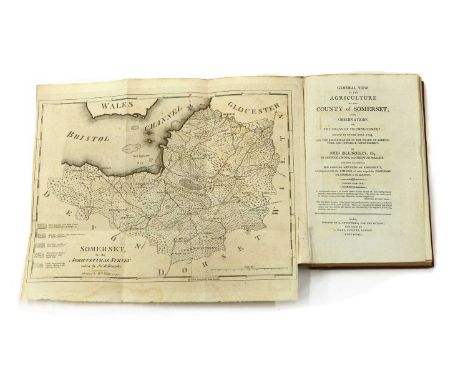
Lot 28
1- Cooke, G A: Topographical and statistical description of the county of Wilts. Nd, c1820. With a folding map plus 4 plates on 2 pages; 144pp; ; Bound with: (as above), Somerset. 1820, with a folding map and 4 plates on 2 pages. 180pp; 2- Billingsley, John: Great view of the agriculture of the county of Somerset.. Bath, 1798, 2nd. Edn. With a folding frontis Map, a folding plan and one plate. 320pp. Leather backed boards and new clamshell box.; 3- Chubb, T: A descriptive list of the printed maps of Somersetshire, 1575-1914. Taunton, 1914, 1st. With 16 maps. Original cloth; rubbed and frontis detached. New slipcase; 4- Tunnicliffe: Survey of the county of Dorset. Text section, disbound; PP: Double-page index table, 91-256, 8+8 (shields of the nobility and gentry. Special clamshell box; 5- Speed's atlas of England & Wales. King Penguin, 1953, dw. in a recent clamshell box (5)Provenance: From a private Somerset map collection.
-
108737 item(s)/page