We found 109182 price guide item(s) matching your search
There are 109182 lots that match your search criteria. Subscribe now to get instant access to the full price guide service.
Click here to subscribe- List
- Grid
-
109182 item(s)/page


Lot 3001
ROBERTS, David, R.A. Egypt & Nubia. F.G. Moon, London. 1846 & 1849. 1st standard edition. 2 vols, Folio. Presented in green half leather with pimpled cloth to boards. Gilt titling to boards and spine. 42 full page and 42 half page lithographs plus one full page map, after Roberts, by Haghe. [2]Condition report: Leather worn at extremities.A few of the full page tissue paper guards for plates missing.Some light foxing, affecting a few of the plates.Vol 2 lacking free endpapers.Vol 2 internal front hinge split from top to bottom. In addition to these comments:The list of plates given in volume two is not particularly helpful in respect of these volumes. There are discrepancies between the list and the order of the plates in the volumes themselves. There are also major discrepancies in terms of spellings (at least three variants of Karnac, for instance) and the Illustrated title page for Volume 2 is incorrectly labelled as Volume 1- this erased and Volume 2 inserted in ink.I list below the actual plates as they appear in each volume:Volume 1Full page:Frontis Aboo SimbelPortico of Temple on Kom OmboTemple Aboo SimbelPortico of EdfouThebesInterior of Temple Aboo SimbelLuxor from NileSphinx and PyramidsKarnacObelisk LuxorTemple EsnehIsland of PhilacTemple KalabshiLybian MountainsTemple of EdfouTemple of EdfouDenderaKarnackTemple of PhilaeTemple of PhilaeGrand Portico PhilaePart Page Plates:Geeza from NilePompey’s PillarTafa, NumbiaGyrshe, NubiaMemnon, Plain of GoornaSanctuary Aboo SimbelLuxor from SWSphinxDakke, NubiaCleopatra’s NeedleMaharraka, NubiaWady KardassyAbyssinian SlavesLuxorWady SabouaTemple of LuxorDenderaSioutNubian WomenCaves of Beni HassanWady SabouaVolume 2Full Page:Frontis Temple of Aboo SimbleTitle KarnackMemnoniumMemnoniumTemple of AmunHadjar SilsilisKarnacKarnacMedinet AbouMedinet AbouTemple of PhilaePyramids of GeezahTemple of DenderaIsland of ElephantineKarnacKarnacTombs of the Kings of ThebesStaves of MemnonTemple of LuxorEdfouKom OmboMap of Egypt & NubiaPart page:Nubians at Wady KardassyIbrim, NubiaWadi SabouaWater wheelPhilae at sunsetHall of Columns KarnackIsland of BiggeMedamountTemple of A’madaTemple of DandourTemple of IsisTyphonaeum at PendesWady KardassyObelisk of OnTemple of Wady DabodDayr-el-medeenahAboo SimbelNile near Wady DabodKalbsheeErmetIsland of Philae I have taken a selection of photographs of the plates, covering the best and worst examples. For the vast majority the plates are clean. A few have very minor foxing and one or two have a slight damp stain. See photos.


Lot 2027
France, Universal Exposition 1878 medal in bronze by Eugene Andre Oudine (1810-1887), obv; Allegory of the Exposition crowning Arts, Commerce, Industry and Agriculture, rev; two cherubs hold a scroll map of the Exposition, together with a Franco-Brazileira gilt bronze Paris 1889 Exposition medal. (2)
Lot 2063
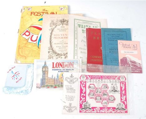
A collection of 1951 Festival of Britain guides, souvenirs and ephemera to include Burnley Music & Drama Official Handbook, "Geographica" "All in One" Map Guide Festival London, Battersea Park Pleasure Gardens Guide x2, The Festival of Punch, Lambeth Palace Art in the Service of the Church Exhibition, National Book League Book Exhibitions, An Illustrated Story of The London Theatres in the Great Exhibition Year of 1851, The Regency Festival Souvenir Programme, London Souvenir stamps, Festival trains The Red Rose, Commemorative Poster Stamps, Souvenir Handbook and What's On Today Battersea Park Pleasure Gardens Official Programme etc.
Lot 2067
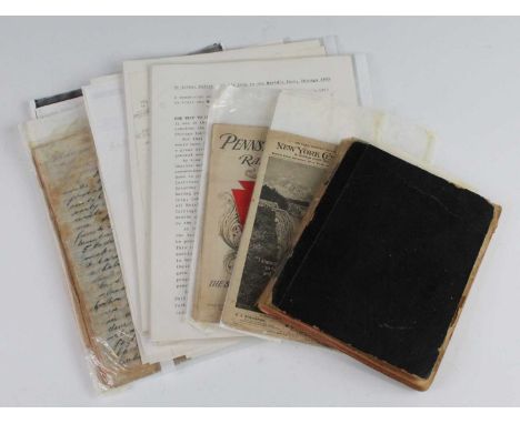
A collection of ephemera relating to the 1893 World’s Fair in Chicago, to include a hand-written diary describing the writer Arthur Walter Carter’s decision to travel to America for one month as part of a group tour with Regent Street Polytechnic (later to spawn the Poly travel company and team up with Sir Henry Lunn as Lunn Poly), his journey by ship as a 2nd class passenger from Southampton to New York, sight-seeing in New York, travelling by train within America, attending a Presidential reception in Philadelphia, as well as visiting the World’s Fair in Chicago, then onwards to Niagara Falls before journeying home. The notebook also includes a pasted-in map of Chicago with notable sites, leaflet from The Polytechnic outlining the tour, the ships programme of entertainment, tickets, an extract from the out-going voyage ‘S.S. New York Gazette’, a leaflet for the Cave of the Winds at Niagara, the Saloon Passenger List for the return journey, and a leaflet for American Line Steamers. a Pennsylvania Railroad timetable with map verso, a New York Central & Hudson River Railroad timetable and a loose-leaf letter written home upon Carter's arrival in New York, dated June 3rd 1893. Condition report: Diary – 118 numbered and hand-written pages (both sides), approx. 8 pages towards back with inserts stuck in, approx. 25 blank pages at end; some minor tears, yellowing, creases and foxing to pages; spine and covers sellotaped back together. See images.No real provenance as the late vendor was an avid collector of everything to do with Great Exhibitions and World’s Fairs, but there are some notes and a typed transcript which imply that publication was considered at one point.
Lot 2072
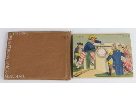
A collection of miscellaneous items all relating to various British and World Exhibitions, to include Souvenir De Paris Exposition Universelle 1878 leather bound book of photographs, Montreal Expo67 Mini album, Valentine's Snapshots "An Clachan" Empire Exhibition album and Empire Exhibition Scotland 1938, stereographic viewing cards, 12 Snapshots of Antwerp Exhibition 1930 x4, Exposition Paris 1937 10 colour photo's, The New Wembley 1925 British Empire Exhibition Guide, a 1951 Festival of Britain News Chronicle London Map and Guide, Franco-British Exhibition giant postcards, The World of Tomorrow New York World's Fair 1789-1939 six panel peep-show book in envelope, two full sheets of Festival of Britain stamps and various 1st day covers and used stamp envelopes etc.
Lot 2077
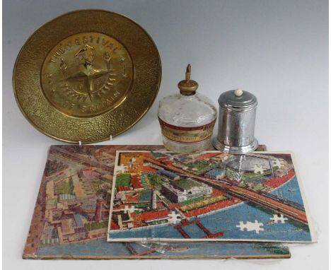
A collection of miscellaneous items mostly relating to various British and World Exhibtions to include The British Empire Exhibition Wembley 1924 Souvenir of the Great Western Railway, a Catalogue of an Exhibition arranged by The Arts Council of Great Britain Sculpture & Drawings by Henry Moore, 1951 Britsh Railways London Transport map, 1951 Norwich Festival Diary, 1948 London Olympics closing ceremony ticket stubb, J.T. Staton - Th' Visit to th' Greight Parris Eggsibishun of Bobby Shuttle un his Woife Sayroh 1867 1st edition, Souvenir photograph of H.M.S. Gabbard, 1904 Italian Exposition in London menu, The South Bank Exhibition 200 piece jigsaw puzzle, Festival of Britain Hunt's Port botlle (empty), a brass tray, a commemoration teapot and various ephemera etc.


Lot 162
JOHN SPEED hand-coloured antiquarian map - 'The Countye of Monmouth with the sittuation of the Shire-towe Described Ann 1610 - Performed by John Speed and are to be solde in Popes head alley against the Exchange by John Sudbury and George Humbell, anno domini 1610 Cum Privilegio Regis', includes Monmouth town plan, 38 x 51cms Condition: later coloured, paper browned, tear and repaint to lower centre margin, tear to upper crease


Lot 304
H.I. KERR, LOCH LEVEN AND GLENCOE MOUNTAINS, watercolour on paper, signed and titled, 16.5cm x 20.5cm Mounted, framed and under glass, 29.5cm x 39.5cm overall, along with a companion piece by the artist, a watercolour of a wren by Sue Quinn, a map of Hartfordshire, Orrefors glass poster and others including etchings, each framed and under glass (13)


Lot 4045
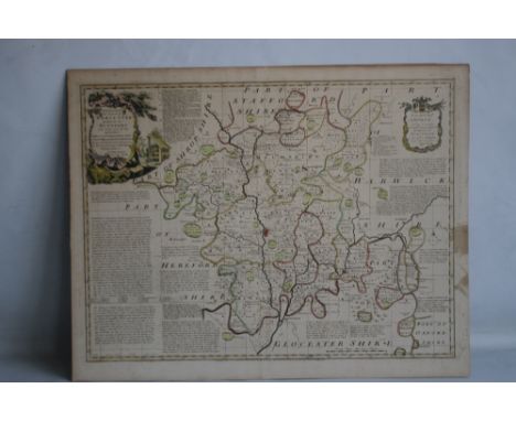
Christopher Greenwood (1786-1855) and John Greenwood (fl.1821-1840), Map of the County of Derby, from an Actual Survey made in the Years 1824 & 1825, Published by the Proprietors Greenwood & Co., 13 Regent Street, Pall Mall, London 1830, two-fold engraving, hand-coloured delineations and gradients, decorative title, the lower left-hand margin with a vignette of Chatsworth after Creighton, 58cm x 69cm

Lot 4046
Christopher Greenwood (1786-1855) and John Greenwood (fl.1821-1840), Map of the County of Derby, from an Actual Survey made in the Years 1824 & 1825, Published by the Proprietors Greenwood & Co., 13 Regent Street, Pall Mall, London 1830, two-fold engraving, hand-coloured delineations and gradients, decorative title, the lower left-hand margin with a vignette of Chatsworth after Creighton, 67.5cm x 78cm

![John Speed (1552-1629), a county map of the West Riding of Yorkshire, [London: 1627], hand-coloured engraving, 38.5cm x 52cm](https://cdn.globalauctionplatform.com/8f6ed392-12bf-406c-95f7-ad27009c49c3/f8363828-bd69-443b-92f9-ad2e00f01f6d/468x382.jpg)
![John Speed (1552-1629), a county map of Yorkshire, [London: 1676], hand-coloured engraving, 39cm x 51.5cm](https://cdn.globalauctionplatform.com/8f6ed392-12bf-406c-95f7-ad27009c49c3/c4da5559-451e-4d68-980e-ad2e00f02066/468x382.jpg)
Lot 4053
Local Interest, Derby and Derbyshire - a collection of maps and ephemera, comprising, Derby, Board of Health Map, 120in: 1 mile, engraved and a printed in colour by Bemrose 1852, originally in four sheets each of 99 x 66cm: two copies SW section, also NW and NE sections; County Borough Council, Architects? office, C. H. Aslin, CBE, Central Improvement Plan phase 2 1944 (not built), in which it was envisaged that the centre of the town would be entirely rebuilt around a new plaza on the site of the Market Place: map of intended layout of Market Place from Albert St to the Cathedral, also map of revised traffic flow in and around the town centre, of which only Traffic Street was built 95 x 98cm each; Derby map, 1815, complied from original sources and drawn on cartridge paper by Kevin Archer of Littleover, with key to locales, armorials, MS signature of the compiler with date April 2001, 55 x 76cm; Allestree Lordship map, 1727, copy drawn from the original by Kevin Archer of Littleover, cartridge paper, Mundy armorial 36 x 45cm; Facsimile map of Derby 1791 after George Moneypenny, on cartridge paper, 33 x 30 cm; Derby OS 1:2500 map 1884 edition, copies of sheets XLIX.16 (California), L.13 (Derby E), LIV.4 (Littleover and Normanton (two), LIV.8 (Sinfin), LV.1 (Peartree & Osmaston) & LV.5 (Cottons); two reproduction prints of Bemrose lithographs showing Derby from the Meadows, and Derby from Exeter Bridge, c. 1847, both printed on cartridge paper and named, each 40 x 30cm; Conduct and Proceeding of the Rebels in Derby, reproduced in facsimile from the Derby Mercury 9/12/1745, being the paper?s account of Bonnie Prince Charlie?s stay in Derby 4-6th December 1745, with other similar extracts printed in facsimile on the reverse; Ashbourne, facsimile of the 1830 map of the town by the ?pupils of Mr. Jones?s Academy? scale 44yds: 1in., with two vignettes (church and hall) 63.5 x 43.5cm; Bolsover Civic Society poster 88 x 62cm printed on cartridge paper with descriptions, plans and elevations of buildings including the Castle 1982; Egginton, map printed on cartridge paper embellished with vignettes and descriptions, drawn 1994 in aid of St. Wilfrid?s parish church at the request of Sir Henry Every, Bt., signed by the artist, 64 x 45cm; Long Eaton Hall: three copies of Erewash Borough Council drawings made in 1922 by H. Raven, Long Eaton Urban District Council surveyor when it was proposed to purchase the property as the town hall: block site plan 46 x 77cm; plans of the hall and outbuildings by H. Raven scale 8ft:1in, 100 x 70cm & east, south and west elevations of the hall 8ft: 1in H Raven 75 x 54cm; Radbourne, three plans copied from originals in the County Record Office: plan of 1711 drawn by Thomas Hand showing the previous house and immediate surroundings 84 x 59cm; copy of a plan of part of the estate, mid-18th century 42 x 29.5cm, also copy of William Emes?s map of 1790 showing his proposed alterations to the landscape 83 x 60cm; Renishaw Hall glossy poster 42 x 59cm advertising exhibition John Piper at Renishaw September 1999 with large colour print after Piper of Montegufoni (Sir George Sitwell?s Italian house); South Wingfield, facsimile of the tithe award map 1845 (DRO 13b) 86cm x 86cm; Genealogy: two hand scrivened pedigrees relating to the Tymperley family: pedigree of George Arderne and Sibyll Arderne of Tymperley, Cheshire, showing descent from Sir John Tymperley via John Chatterton, abstracted from the Heralds? Visitation of Cheshire 1580, 48 x 60cm, also pedigree of Tymperley of Hintlesham, Suffolk, abstracted from the Heralds? Visitation of Suffolk, 1664, 31 x 45cm, the latter in clear plastic carrying tube, (qty)


-
109182 item(s)/page