We found 109198 price guide item(s) matching your search
There are 109198 lots that match your search criteria. Subscribe now to get instant access to the full price guide service.
Click here to subscribe- List
- Grid
-
109198 item(s)/page
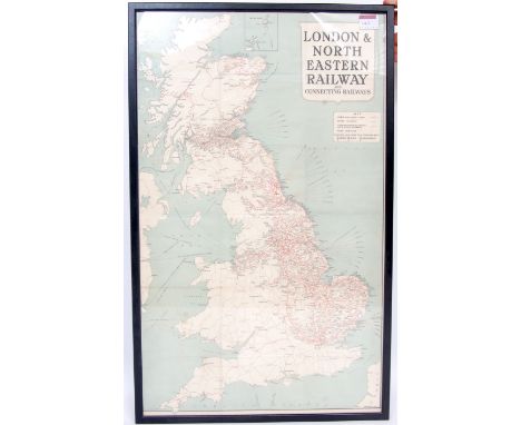


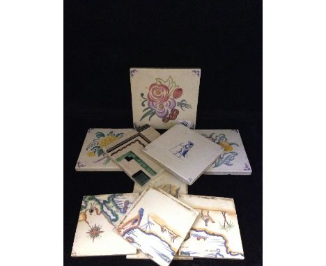
Lot 252
Three various early 20th century Poole Pottery tiles decorated in traditional floral bouquet patterns together with an Art Deco tile and a tile decorated with a Continental soldier in costume together with five tiles painted as a panel decorated with a map of the Mediterranean (one tile missing from map and probably not Poole).


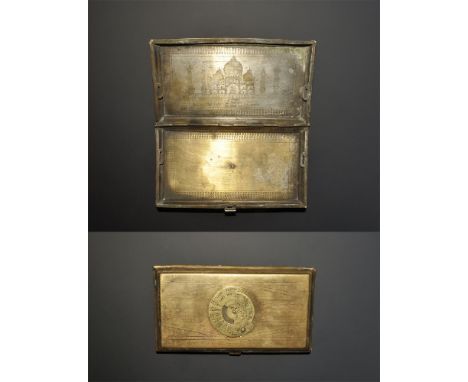
Lot 205
20th century AD. A hinged cigarette case with 25-year calendar to the lid, sketch map of India and Southeast Asia to the reverse, image of the Taj Mahal in punched-point work to the inner lid with signature 'Aneel K'. 201 grams, 15cm (6"). From an old London collection, formed in the 1980s. [No Reserve]


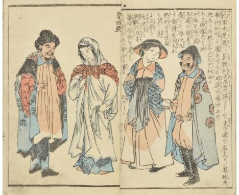
Lot 138
Shundo (Tagawa and Kurata Togaku). Gaiban yobo zue (Appearances of Foreigners), 2nd edition, 2 volumes, Edo, 1855, colour woodblock printed, double-page map of the world, numerous colour illustrations showing peoples of the world, contemporary paper wrappers sewn, contained within japanese chemise, small 8vo The first edition, published in 1854, represented Japan's new-found interest in the wider world having been opened to outsiders in 1853 by Matthew Perry. (2)
Lot 363
*Canals. A Plan for a Navigation Chiefly by Canal from Longbridge near Burslem in the County of Stafford to Newcastle, Lichfield and Tamworth, and to Wilden in the County of Derby, by James Brindley, Revis'd and Approv'd by John Smeaton, 1760, manuscript plan drawn by Hugh Henshall, ink on paper with map showing canal, river, occasional churches and dwellings plus Lichfield Cathedral, title cartouche, compass rose and columns of copperplate writing giving details of landowners, ink-ruled border, vertical central crease, somewhat dust soiled and numerous marginal splits and nicks but without loss of text, a few crude paper repairs to verso, two old ink notes to verso noting 'The original plan of the Grand Trunk drawn by H. Henshall from which the plate was engraved', 54.5 x 75cm Hugh Henshall (1734-1816) was an English civil engineer, noted for his work on canals. Henshall worked with Brindley and John Smeaton in 1758 to survey the proposed Trent and Mersey (Grand Trunk) Canal. (1)


Lot 155
Livingstone, Missionary Travels and Researches in South Africa, John Murray, London 1857, signed by Livingstone and dated 29th October 1857 CONDITION REPORT: Spine in very poor condition, covers slightly worn, bumped and rubbed. Front cover rather loose. Inscription to blank front page. 1st folding illustration has watermark to left hand margin. Some pages slightly dirty. Fold out map of South Africa present to back. Another fold out map of Africa present to interior of back cover.
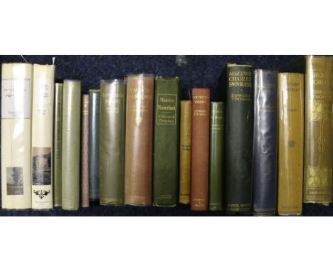
Lot 181
Thomas, The Ickwild Way, Constable, London, 1913 and Cloud Castle, Duckworth, London, 1922 and fifteen further volumes by Thomas, many 1st editions and including, Eckert, Edward Thomas, Biography and Bibliography. (17) CONDITION REPORT: These covers are facsimiles. Top edge of Icknield Way is gold. Icknield Way is 1st edition. Clound Castle is a second issue of 1st addition. Cloud Castle - basshed to bottom and top of spine. Covers generally good otherwise. Slight yellowed paper, very slight foxing and beginning and end paper. Icknield has foxing through most pages particularly towards the leading edge of pages. Map is present. Bumped corners and bottoms top of spine. Slight loss to Publishers name on shelf back.

Lot 154
Troup, With Stanley's Rear column, Chapman & Hall, London 1890 CONDITION REPORT: Bumps to top and bottom of spine and slight rubbing at author on back spine. Very slight bumps to corners. Tears to inside front cover (brown paper lining) at spine. Fold out map present at front of Chapter 1. Slight tear c5cm at bottom right joing with page. Some very slight foxing. Library stamp for Forestry Commission Hostel, Benmore. Henry Johnston Younder pasted in on inside front cover.


Lot 1920
History of the Quakers Being the rise and progress of the Christian people called Quakers, the beauties of the reverend J Wesley, printed by JD Dewick, London 1805, a fold out map of the Punjab circa 1916 and a copy of The Life of Christ printed and sold by Joseph Aston, Manchester circa 1800. (4)

Lot 1931
Doomsday Book Studies - Cheshire Edition Containing three books including a map in slip case, published by the Alecto Historical Editions, London 1987, further books on Cheshire to include Romantic Cheshire by J Cumming Walters, Lancashire, Cheshire and the Isle of Man by Freeman Rogers Kinvig, County Plan for the Palatine of Cheshire by W. Dobson Chapman, the Manor of Gawsworth by Raymond Richards, Picturesque Cheshire by T.A. Coward, Curiosities of Town and Countryside by Edmond Vale, Sussex Archaelogical Collection dated 1947, further books etc. (32)


Lot 1930
Doomsday Book Study - Cheshire Edition Containing three books including a map in a slip case, published by the Alecto Historical Editions, London 1987, further books on Cheshire to include a History of Cheshire by George Lee Fenwick published in Chester 1896, further volumes to include Romantic Cheshire, Cheshire and its Welsh Borders by Herbert Hughes, Arthur Mee's Chester, Chester as it Was by the Dean of Chester and Alfred Rimmer Esq, dated 1872, Diary of Charles II by Sydney in two volumes, Country Diary of a Cheshire Man by W. Boyd, Belgium by Forestier etc. (25)


Lot 3512
Derbyshire - Glover, Stephen, The Peak Guide, Containing the Topographical, Statistical, and General History of Buxton, Chatsworth, Edensor, Castleton, Bakewell, Haddon, Matlock and Cromford, Henry Mozley and Son, (Derby 1830), 130pp, engraved map to end paper with vignette of Buxton Crescent, green cloth boards with paper label and price of five shillings and sixpence

Lot 3516
Glover (Stephen), The History and Gazetteer of the County of Derby: Drawn up from Actual Observation, and from the Best Authorities: Containing the Parochial and Family History, Biography, and Statistical Information, edited by Thomas Noble, Esq., Henry Mozley and Son, Derby 1829-33, volume I and volume II - part II [complete as published], pull-out county map to title page, pull-out pedigrees, original boards, 8vo


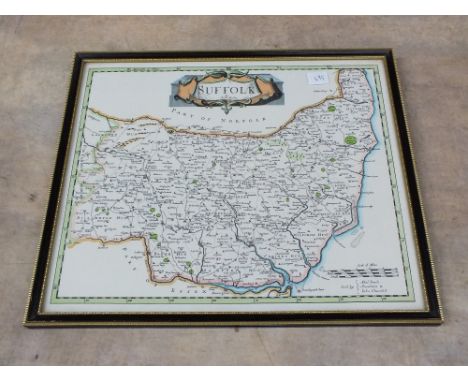
Lot 497
Pictures and Prints - John Bangay (Contemporary), after, Lincoln, The Caste Gate from Inside, ink drawing, dated '75, titled and signed in ink, 10.5cm x 14cm; another, The Glory Hole, Lincoln; a Day and Son county map of Hertfordshire, framed, 32cm x 43cm; another, similar, smaller, Middlesex, 19cm x 24cm; etc. (18)


-
109198 item(s)/page