We found 109198 price guide item(s) matching your search
There are 109198 lots that match your search criteria. Subscribe now to get instant access to the full price guide service.
Click here to subscribe- List
- Grid
-
109198 item(s)/page


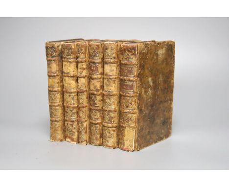
Lot 1289
° Rabelais, Francois - Oeuvres……New Edition, 6 vols, mottled calf, 12mo, with portrait, 3 folded plates and a folding map, staining to early fly-leaves and half title to vol. 2, small loss to upper left front board of same, 3cms. loss to lower spine to vol. 1, [Pierre-Charles Jamet and Thomas Gueulette] Paris, 1732


Lot 981
A collection of 14 books on Essex and a map: Victorian County History of Essex Vol 1; A history of the county of Essex Vol 2, 4, 5, VI, VIII, 1X; The County of Essex - Ancient and Modern History; Domesday book of Essex; The Parishes of Essex map; The place names of Essex; The field names of Essex by W C Waller; The Forest of Essex; Epping Forest then and now; Victorian County History of Essex supplement


Lot 58
An original WWII Second World War RAF Royal Air Force / British Military Escape Map c1944. South-east Asia sheets 44 J and K. Two back-to-back escape maps on one folding silk map. Size 95 by 60 cm. Scale 1:000,000. Folds to pocket handkerchief size or smaller. Side J covers French Indo-China (central), Siam (Thailand east) and side K covers an area of French Indo-China (south), Siam (Thailand- part). Maps are in colour with a colour-coded key to heights and a conventional key to features such as mountains, islands, railways, stations, ruins, post offices, roads etc.


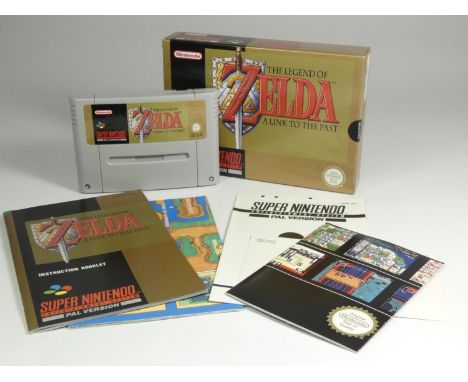

Lot 7
Doctor Who and the Mines of Terror for Commodore 64, with original case, instructions on loading the game in four languages, briefing booklet for the Rijan Mission, icon chart, Rijan Mining complex map, key card in original case and assistance leaflet with instructions on how to distract a Madrag To be sold on behalf on Monkey World, Dorset


Lot 211
Wadsworth (Edward) and Bernard Windeler. Sailing-Ships and Barges of the Western Mediterranean and Adriatic Seas, one of 450 copies, additional engraved title, 17 plates, map and vignettes by Wadsworth, most delicately hand-coloured, original buckram-backed pictorial orange cloth, gilt, upper cover damp-mottled and partially faded, slip-case rubbed and soiled, small folio, Curwen Press, 1926.


Lot 146
British Isles. Willdey, George. Map of Great Britain and Ireland, 1715. Hand-coloured copper engraving on laid/chain-lined paper, featuring inset depictions of Hercules and Hydra, George I, Shetland Islands, royal coat-of-arms, naval scene, Willdey's wares. 96cm by 65cm. Toning from age, creasing and fold-lines with splitting and areas of wear/loss, old paper reinforcements to verso, some later hand-colouring, very fragile, folded

Lot 149B
Schenk & Valk. Map of Leicestershire, c.1715, hand-coloured copper engraving on laid/chain-lined paper, featuring armorial shields and figures, 53.5cm by 62.5cm, framed & glazed. Appears well-preserved and bright, wide margins, light cockling to extreme edges of margins, unexamined out of frame

Lot 149C
John Speed (1552-1629). Map of Rutland, c.1676, hand-coloured copper engraving on laid/chain-lined paper, featuring inset views of Oakham and Stamford, published by Bassett & Chiswell, 43.5cm by 55.5cm, framed & glazed to recto and verso (both sides visible), appears bright, weak impression, some pale staining along left margin. Together with a similar Speed map of Nottingham, 1676 or later, featuring armorial shields and inset view of Nottingham, published by Bassett & Chiswell, 39.5cm by 51.5cm, a Schenk & Valk map of Lincolnshire, 45cm by 54cm, heavily discoloured, and four smaller, later maps, including Moule & Bowen (7)

Lot 147B
Robert Morden (1650-1703). Map of Norfolk, hand-coloured copper engraving on laid/chain-lined paper, 38cm by 62cm, framed & glazed. Appears well-preserved with slight loss at corners, unexamined out of frame. Together with three smaller maps of Cornwall, Lincolnshire, Staffordshire and Cambridge, two of which are by John Cary, and a modern facsimile of Saxton's map of Staffordshire by Taylowe, 1960 (5)

Lot 34
Beattie, William. Scotland Illustrated in a Series of Views Taken Expressly for this Work by Messrs. T. Allom, W. H. Bartlett, and H. McCulloch, in two volumes, London: George Virtue, 1838, folding map, 123 steel-engraved plates and two vignette titles, quarto, half-calf with marbled boards, morocco title labels lettered in gilt, marbled endpapers, armorial bookplates for A. G. Archibald, plus neat recent bookplates, general discolouration and some pale spotting to contents, bindings tight and solid with some rubbing and wear, bumping and wear around spines/headcaps/corners (2)
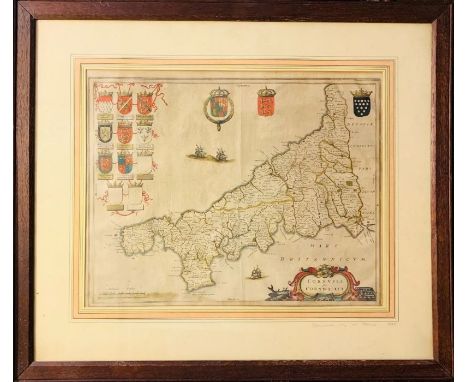
Lot 147A
Joan Blaeu (1596-1673). Map of Cornwall, c.1645, hand-coloured copper engraving on laid/chain-lined paper, featuring armorial shields and ships. 40cm by 50.5cm. Framed & glazed. Appears well-preserved with attractive, creamy laid paper, some light staining along bottom, early colour, unexamined out of frame


Lot 501
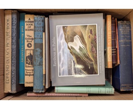
Cameron (Lucy Lyttleton). Amelia, 7th edition, London: Houlston & Co., circa 1840, wood engraved frontispiece and illustrations, bound with Sherwood (Mary Martha), The Thunder-Storm, 6th edition, London & Wellington, Salop.: Houlston & Son, 1837, wood engraved frontispiece and illustrations (frontispiece laid-down to final leaf of previous work, bound with Houlston & Son (publishers), William and George. The Rich Boy and the Poor Boy, or, a contented mind is the best feast, London & Wellington, Salop.: Houlston & Son, circa 1830?, wood engraved frontispiece and illustrations (frontispiece laid-down to final leaf of previous work, bound with Houlston & Son (publishers), The History of Little Goody Two-Shoes, London & Wellington, Salop.: Houlston & Son, 183Save1, wood engraved frontispiece and illustrations (frontispiece laid-down to final leaf of previous work, bound with six other similar works (one with single leaf of text excised and with consequent loss of text), occasional dust-soiling and scattered spotting, contemporary half cloth, light wear, 16mo in 8s, plus Blair (David), The Universal Preceptor; being an easy grammar of arts, sciences, and general knowledge, 2nd edition, London: Richard Phillips, 1811, folding engraved frontispiece and folding map, wood engraved illustrations, toning and scattered spotting, contemporary sheep, rebacked, boards rubbed, 12mo in 6s, Harvey & Darton (publishers), Midsummer Holidays at Briar's Hall; or, summer mornings improved, London: Harvey & Darton, 1828, engraved frontispiece and five plates, some browning, contemporary maroon morocco-backed printed boards, worn, 12mo, Ardizzone, Edward (illustrator), Pictures on the Pavement by G.W. Stonier, 1st edition, London: Michael Joseph, 1955, monochrome illustrations throughout, original cloth in dust jacket, spine of dust jacket slightly frayed at head & foot, 8vo, plus other 19th & 20th century children's and illustrated books, etc.Qty: (a carton)
Lot 811
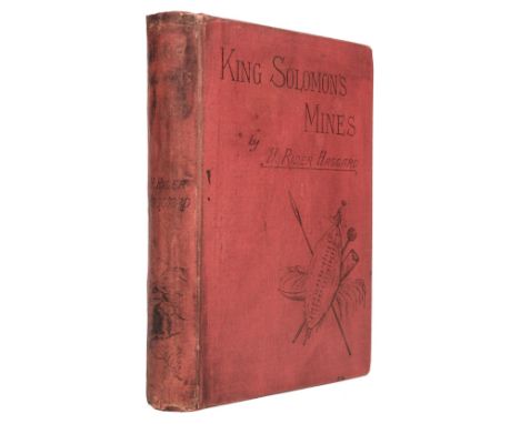
Haggard (H. Rider). King Solomon's Mines, 1st edition, 1st issue, Cassell & Company, 1885, folding map, half-title, publisher's catalogue, contemporary ownership inscription to front free endpaper, occasional marginal dust-soiling and staining, original publisher's cloth, rebacked with original spine laid on, spine with loss to extremities, spine toned and stained, boards faintly marked, corners bumped, 8voQty: (1)Footnote: The scarce first issue with "Bamamgwato" for "Bamangwato" on p. 10, line 14; "to let twins to live" for "to let twins live" on p. 122, line 27; and "wrod" instead of "word" on p. 307, line 29, and with publisher's catalogue dated 5 G. 8.85.

Lot 865
Priestley (J.B.) Angel Pavement, 1st edition, London: William Heinemann, 1930, original cloth, dust jacket, small nicks at head of spine, 8vo, together with Hughes (Richard). A High Wind in Jamaica, 1st edition, London: Chatto & Windus, 1929, a few spots, original cloth, dust jacket with Choice of the Book Society wraparound band (small tear and loss at head of spine), 8vo, plus Dunsany (Lord). Tales of War, 1st edition, Dublin: Talbot Press/London: T. Fisher Unwin, 1918, partly unopened, a little marginal toning, original cloth-backed boards, dust jacket, spine a little rubbed and toned, 8vo, plus others including Lord Dunsany's If. A Play in Four Acts, 1921, C.E. Montague's Right Off the Map, 1927 (limited signed edition 34/260), R.H. Mottram's Europa's Beast, 1930 (limited signed edition 122/358) and plays and novels by John Galsworthy in dust jackets including Captures, 1923, A Modern Comedy, 1929, Flowering Wilderness, 1932 and Over the River, 1933Qty: (23)
Lot 886
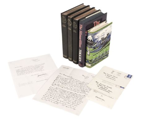
Tolkien (J.R.R.) Lord of the Rings: The Fellowship of the Ring, 13th impression, 1963; The Two Towers, 10th impression, 1963; The Return of the King, 10th impression, 1963, folding map at end of each, bookplates of Suzanne Eward, all edges gilt, original black cloth, spines lettered in gilt, 8vo, together with The Hobbit, 5th impression, 1970, and The Silmarillion, 1st edition, 1977, with two letters to Suzanne Eward from J.R.R. Tolkien, one a 2 pp. autograph letter dated April 23 1972 on Merton College Oxford headed paper donating the above Lord of the Rings and Hobbit to Gloucester Cathedral Library, "I protest that your letter seemed to me neither an impertinence nor a presumption, but a very high compliment. All the more welcome as coming from Gloucester. My love is given above all other regions to the 'West Midlands', in which I lived as a child. My mother belonged to a Worcestershire family; my wife to one of Staffordshire, though she was actually born in Gloucester, and later lived for some years in Cheltenham... I will certainly present copies of any of my works which the Dean and Chapter think worthy of Including in their library. I suggest that copies of each of the 3 vols of the Revised Edition would be more suitable than the later 1 vol. edn. on India paper. Also that this should be accompanied by a copy of The Hobbit: in the reprint of the edn. with coloured illustrations (which was mostly burned up in the Blitz of London)... With regards to signature, to avoid the trouble and expense of postages I usually send inscribed labels of which I enclose a specimen... with best wishes, yours sincerely J.R.R. Tolkien", with the signed label, inscribed "Presented to the Gloucester Cathedral Library by J.R.R. Tolkien" folds and a few minor spots to the letter; the other letter a 1 pp. typed letter signed, dated 5th May 1972, stating that he had ordered from publishers Allen & Unwin the three volumes of Lord of the Rings and The Hobbit to be sent to the Dean and Chapter of Gloucester Cathedral Library, plus four signed labels (not present here), and a postscript "I am sorry that it is not possible to find copies of the first editions for presentation", folds and a few spots, both letters contained in the original envelopesQty: (7)Footnote: The recipient of the books and letters was Suzanne Mary Eward, former Librarian and Keeper of the Muniments at Gloucester Cathedral and Wells, and latterly at Salisbury Cathedral.

Lot 888
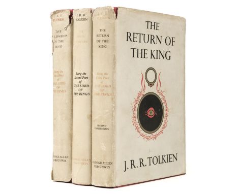
Tolkien (J.R.R.) The Lord of the Rings: The Fellowship of the Ring, 5th impression, 1956; The Two Towers, 2nd impression, 1955; The Return of the King, 2nd impression, 1955, folding map at end of each, previous owner signature to Fellowship front endpaper, a couple of small stains to one or two endpapers, top edges red, original red cloth gilt, dust jackets, some fading to spine lettering, a few chips, tears and stains, 8voQty: (3)
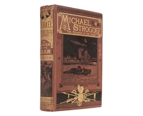
Lot 889
Verne (Jules). Michael Strogoff, The Courier of the Czar, London: Sampson Low, Marston, Searle & Rivington, 1877, frontispiece, 89 illustrations, folding map, bookplate & bookseller's ticket to front pastedown, stamp to title, stamp to text leaf offset to map, occasional spotting, original publisher's cloth, all edges gilt, boards marked, corners bumped, extremities slightly rubbed, 8voQty: (1)

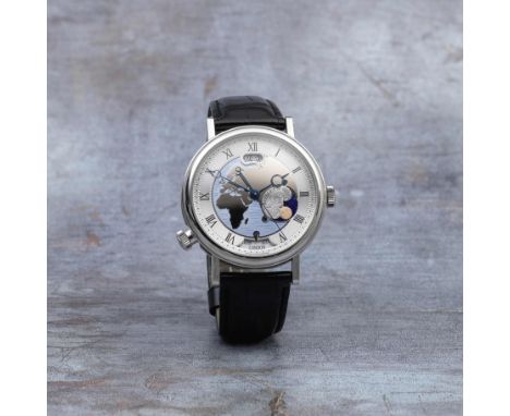
Lot 52
Breguet. A fine platinum automatic calendar wristwatch with world time and day/night indicationModel: Hora MundiReference: 5717Date: Circa 2011Movement: 39-jewel Cal.77F0 automatic, platinum rotor segment, No.0010455Dial: Central panel with polished world map of the European and African continents with blue enamel surround, black Roman numerals to brushed outer silvered chapter, black outer minute divisions, Breguet secret signature either side of 12, date aperture below 12, day/night indication at 4, aperture at 6 for 24 cities of the world, blued steel Breguet hands, centre secondsCase: Polished round, exhibition back secured by 8 screws, reeded band, world city setting crown at 8, No.929AWStrap/Bracelet: Black Breguet alligator leatherBuckle/Clasp: Signed platinum folding claspSigned: Case, dial & movement Size: 44mmFootnotes:The Hora Mundi features an instant-jump time-zone display system. This watch combines this iconic complication with synchronized indications for date, day/night and city, therefore enabling the wearer to instantly switch the time for two pre-selected time zones.Three variations of the Hora Mundi watch are available and each of them depicts one part of the globe; the European and the African continent, the Americas, or Asia and Oceania. The Hora Mundi is an unusually large watch for Breguet at 44mm adding to its interest for collectors.This lot is subject to the following lot symbols: YY Subject to CITES regulations when exporting items outside of the EU, see clause 13.For further information on this lot please visit Bonhams.com

Lot 12
Omega. A rare and desirable stainless steel manual wind chronograph bracelet watch made for the Italian marketModel: Speedmaster Apollo SoyuzReference: ST 145.022, Limited Edition No.159Date: Manufactured 3rd May 1976, Purchased 29th May 1980Movement: 17-jewel Cal.861 manual wind, No.39181308Dial: Black, Apollo Soyuz logo at 12, luminous baton hour markers, white outer 1/5th second divisions, subsidiary dials at 3, 6 and 9 for seconds, 30 minute and 12 hour recording, white pointed baton hands with luminous inserts, centre secondsCase: Brushed and polished tonneau form, screw down back engraved Gemini Apollo Союз, shouldered crown flanked by twin pushers, tachymetre to bezelStrap/Bracelet: Fitted brushed 1168 Omega linkBuckle/Clasp: Signed folding claspSigned: Case, dial & movement Size: 41mm Accompaniments: Receipt dated 29/5/80, Omega service case, Extract from the Archives, spare parts replaced during service including original hands and pushersFootnotes:On the 17th of July 1975, in the depths of the Cold War, space became the meeting point of two of the space faring nations, the United States of America and the Soviet Union. Every Astronaut and Cosmonaut were equipped with an Omega Speedmaster Professional and in the case of Alexey Loenov, two. To celebrate this, in 1976 the Jeweller De Marchi of Turin took delivery of a group of special celebratory Apollo Soyuz watches with the mission badge on the dial and a special embossed case back depicting the Saturn Rocket on a map of the world. The back was also lightly engraved with the limited edition number, an I for Italy and an Ω.The present watch was bought new in 1980 at a large discount when it is possible that the Italian market was a difficult place to sell this particular piece. It was soon inherited by the present owner who left it unused in a draw for many years and only sporadically wearing it. For this reason, the dial is in excellent condition with virtually no UV damage. The owner sent it once for a service but kept all of the original parts which are available with the lot.Very few of these original pieces were created and they have been celebrated ever since with anniversary editions being produced at 20, 25 and 30 years.For further information on this lot please visit Bonhams.com


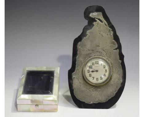
Lot 1189
A George V silver mounted and ebonized strut clock, the surround modelled as a map of Ceylon, the silvered circular dial with Arabic hour numerals and detailed '8 Days', the back with easel stand, Birmingham 1935 by J.B. Chatterley & Sons Ltd, height 18.5cm, together with a mother-of-pearl mounted watch stand with glazed hinged lid, length 9.5cm.Buyer’s Premium 29.4% (including VAT @ 20%) of the hammer price. Lots purchased online via the-saleroom.com will attract an additional premium of 6% (including VAT @ 20%) of the hammer price.


-
109198 item(s)/page