We found 109182 price guide item(s) matching your search
There are 109182 lots that match your search criteria. Subscribe now to get instant access to the full price guide service.
Click here to subscribe- List
- Grid
-
109182 item(s)/page


Lot 2055
EphemeraAn interesting collection including;Motives for Making a Navigable Canal from Barnby Bridge, by Barnsley to .... River Calder, near Wakefield [c.1791], broadside incorporating engraved map (worn);Several books including A Handy Book for Floral Decorators, 1867, four pamphlets by John Galsworthy, Severn Wildfowl Trust booklet signed by Peter Scott, Kipling's Absent Minded Beggar in original printed glassine envelope, etc.;Broadsides including a proposal for the formation of a club in Florence, signed by Norman Douglas and 'A New Gospel Hymn';'An Easter Greeting to Every Child Who Loves Alice' from Lewis Carroll (printed);A small quantity of sketches, two signed by Chesterton;A Jacobean manuscript indenture relating to the Byron family;Original artwork and hand-coloured plates;A quantity of Autograph Letters Signed, including a collection of ALS from Thomas Frost (late 19th/early 20th century) and a small quantity from early 20th century politicians;Cropped signatures, cartes-de-visite;A leather-bound 'book safe' and a leather-bound notebook and slipcase (qty)

Lot 2059
South Wales DirectoriesKelly (E. R.) edit., The Post Office Directory of Monmouthshire and The Principal Towns and Places in South Wales, Kelly & Co., 1871, two folding maps, [12], 500 pages, plus 52 pages of adverts, original cloth;Kelly (A. Lindsay), Kelly's Directory of Monmouthshire and South Wales, 1926, Kelly's Directories, 1926, xiv, 384, xiv, 1724, [2] pages, two folding colour maps (closed tear to Monmouthshire map) advert endpapers, original cloth (faded). (2)PO Directory - Foxing to closed edges, endpapers and some pages, particularly early leaves and maps, endpapers split at hinge, wear to extremeties, particularly rear joint and head and tail of spine.1926 Directory - Some foxing/tanning to closed edges, front hinge weak, ink mark to backstrip, generally near VG.

Lot 2064
Hogg (Alexander, publisher). The New and Complete English Traveller ... written and compiled from the Best Authorities by a Society of Gentlemen ... revised, corrected, and improved by William Hugh Dalton, London: for Alex. Hogg, [1794]. Folio (394 x 228 mm), modern quarter leather, pp. vi 7-520 [8], 74 engraved plates including frontispiece, 17 maps (of which 2 folding), marginal repair to frontispiece, light worming to margins of pp. i-vi and folding general map, small tear to head of pp. 239/40, hole in pp. 473/4,Nicolson (Joseph, & Richard Burn). The History and Antiquities of the Counties of Westmorland and Cumberland, London: W. Strahan; and T. Cadell, 1777. 2 volumes, 4to (282 x 215 mm), 20th-century red-brown sheep, 2 engraved folding maps (that in volume 2 with short closed handling tear), volume 1 foot of front joint cracked,West (Thomas). The Antiquities of Furness, 1st edition, London: for the author, 1774. 4to (266 x 200 mm), contemporary calf, rebacked, engraved frontispiece, map and plan (all folding; various repairs), engraved seal plate, binding worn (4) ESTC T110453 (Hogg), T56128 (Nicolson & Burn), T144672 (West).For the English Traveller ESTC calls for a total of 70 plates and maps only, and the list of plates names just 60 plates and the folding general map. This copy lacks several plates listed but contains many which are not; auction records indicate that 18 maps are often present.

Lot 2067
Paterson (Daniel). Paterson's British Itinerary ... Second Edition Improved, London: Bowles & Carver, c.1800. 2 volumes, 8vo (187 x 101 mm), contemporary marbled calf (rebacked and recornered), xxxv 341-403, 450-633 pp., engraved title-pages, dedication leaf and double-page general map, 386 engraved strip road-maps on 97 leaves (rectos and versos; counted in pagination), text-leaves browned (qty: 2)ESTC T93578, tracing two copies only for this imprint (undated), British Library and Cambridge.

Lot 2069
Charlton (Lionel)The History of Whitby and of Whitby Abbey ..., York: A. Ward ..., 1779, first edition, quarto, folding plan frontis, three engraved plates, lacking final index leaf/leaves, marbled endpapers, contemporary calf gilt [with]Graves (John), The History of Cleveland in the North Riding of the County of York, Carlisle: F. Jollie ..., 1808, first edition, quarto large paper copy, frontis, engraved title, folding engraved map (hand-coloured in outline), eight engraved plates, folding pedigree, contemporary tree calf with gilt tooled spine, Sir H. Vane-Tempest's copy with ms. note to the binder at rear, Vane Londonderry bookplate to both books (2)

Lot 2071
Dugdale (Sir William)The History of Imbanking and Drayning of Divers Fenns and Marshes, both in Forein Parts, and in this Kingdom, London: Alice Warren, 1662. Folio (338 x 210 mm), contemporary panelled sheep (rebacked and restored), pp. [8] 424 [2] (ESTC collation incorrect), 11 engraved folding maps, modern bookplate (Margaret Joan Price), purchase note dated 1823 to front pastedown, worming to fore margins towards front (touching shoulder-notes and a few letters in main text; disappearing by quire K), a few marginal damp-stains to maps, a few maps (e.g. facing pp. 16, 218, 374) trimmed to edge of plate-mark along top or bottom edges, map facing p. 418 slightly soiled, closed tear in sig. Z1, final text-leaf (3I1) repaired. Together with a copy of Aylett Sammes, Britannia Antiqua Illustrata: or, the Antiquities of Ancient Britain, derived from the Phoenicians ... The First Volume [all published], 1st edition, London: Tho. Roycroft, for the author, 1676 (folio, old sheep, rebacked, lacking map, a few tears and losses, stitching loosening towards rear) (qty: 2)ESTC R975.First edition, scarce in commerce. 'An account of the great drainage schemes that had been carried out in the fens, mainly during the Commonwealth years, by the initiative of Lord Gorges and John Thurloe, secretary to the council of state. This book was effectively commissioned by Gorges to advertise the success of the project' (ODNB).

Lot 2097
Cooke (George Alexander)Modern and Authentic System of Universal Geography ...., printed for C. Cooke, no date (frontis dated 1801 or 1807), two volumes, frontis to each, twenty-four engraved maps as called for, 74 (of 76) engraved plates (lacking plates 41 and 59), tape repairs to rear of folding Pacific map, frontis stained, foxing of plates, contemporary leather bindings (well worn, detached boards, tape to spine (2)
![Sanson (d'Abbeville)[Scotland] L'Escosse Royaume en ses deux Principales Parties qui sont Deca et Dela le Tay ...., Paris, Pi](https://cdn.globalauctionplatform.com/14475c71-50ce-4469-99eb-ae1400d34598/c04b8975-c7d2-4f5f-931a-ae99008bc80e/468x382.jpg)
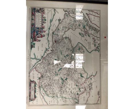
Lot 2098
Sanson (d'Abbeville)[Scotland] L'Escosse Royaume en ses deux Principales Parties qui sont Deca et Dela le Tay ...., Paris, Pierre Mariette, 1665, hand-coloured map, French text, approx. 40cm x 51cm, mounted, framed and glazed.Minor ?ink line to right of scale, o/w no obvious defects. Frame and glass dusty. Not examined out of frame.

Lot 2099
Yates (William)The County Palatine of Lancaster, surveyed by Will'm Yates, 1786, large folding map engraved by Thomas Billinge, sixty-four sections on eight linen sheets (eight sections per sheet), black edged, overall size approximately 210cm x 136cm, housed in quarter calf book-form slipcase. Some tanning and damp/mould staining to parts of map, slipcase well worn.

Lot 2109
James (William)The Naval History of Great Britain, from the Declaration of War by France in 1793 to the Accession of George IV, Richard Bentley, 1837, six volumes, 24 engraved portraits, 28 folding tables, contemporary half calf;idem, Abstracts of the British Navy; Showing how it stood, in Ships, Tons, and Classification, at the Commencement of every Year, from 1793 Inclusive, no date [c.1820], quarto, title and two pages of text, 28 double page tables, 'Notice' slip and 'Additional Errata' slip, full contemporary calf (re-backed) with armorial of Writers to the Signet [spine title 'James' Navel (sic.) History' ].Brenton (Edward Pelham), The Naval History of Great Britain ... [1783] to [1836], Henry Colburn, 1837, two volumes, 24 plates including fold-out panorama of Battle of Trafalgar and folding map of Cadiz (the latter not called for in contents), contemporary half morocco;with eleven others, leather bound (20)
Lot 2156
Bradley (R.)A General Treatise of Agriculture, both Philosophical and Practical; Displaying the Arts of Husbandry and Gardening ..., W. Johnson, R. Baldwin, J. Fuller, et al, 1757, first edition. viii, 503, [17] pages, frontis and twenty plates (eight folding), calf binding with recent spine label (joints a little worn);Boys (John), General View of the Agriculture of the County of Kent, with Observations on the Means of its Improvement ..., Richard Phillips, 1805, second edition, xxiv, 293 pages, folding hand-coloured map (laid down on backing paper, small tear at fold), two engraved plates, folding table, contempory calf (re-backed). (2)
Lot 2160
Lloyd (I.)The Game Birds and Wild Fowl at Sweden and Norway ..., Warne, 1867, forty-eight chromo-lithos, lacking map, original cloth gilt;Whitehead (G.Kenneth), The Whitehead Encyclopedia of Deer, Swan Hill, 1993, folio, dust wrapper;McConnochie (Alexander Inkson) The Deer and Deer Forests of Scotland ..., Witherby, 1923, frontis, thirteen plates as called for, original cloth;with a large quantity of others on Natural History, Field Sports, etc. (qty)

Lot 2166
Noble (John)History, Productions, and Resources of the Cape of Good Hope, Official Handbook, Cape Town, 1886, folding chromolitho frontis and map (map torn at fold), colour and monochrome plates as called for, all edges gilt, publisher's deluxe morocco gilt binding by Saul Solomon;idem, Illustrated Official Handbook of The Cape and South Africa ..., Capetown: J. C. Juta, 1893, folding colour map (tears to folds), monochrome plates as called for, original cloth;with five other Cape Town/Colony Guides (7)

Lot 2173
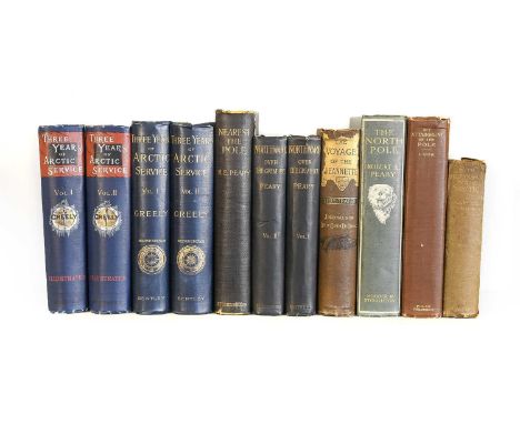
Greely (Adolphus W.). Three Years of Arctic Service, an Account of the Lady Franklin Bay Expedition of 1881-84 and the Attainment of the Farthest North, 1st edition, New York: Charles Scribner's Sons, 1886. 2 volumes, 8vo, original pictorial cloth, steel-engraved frontispieces, 42 wood-engraved plates, 9 maps (of which one folding in end-pocket), together with 7 others (all in original cloth; not fully collated), including: Adolphus W. Greely, Three Years of Arctic Service, 2nd UK edition London: Richard Bentley, 1886 (2 volumes, gilt-stamped 'second edition' on spines); R. E. Peary, Northward Over the "Great Ice", 1st UK edition, 1898 (2 volumes, old manuscript library labels to front covers, volume 1 spine nicked); idem, Nearest the Pole, 1st UK edition, London: Hutchinson & Co., 1907 (title-page blind-stamped 'with the publisher's compliments' and with ink-stamp of Manchester Guardian Library, spine-ends worn, old manuscript library label to front cover); idem, The North Pole, 1st UK edition, 1910 (folding map loose, photogravure plate facing p. 153 absent); and similar (qty: 11)
Lot 2178
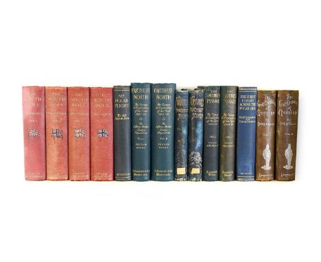
Amundsen (Roald). The South Pole. An Account of the Norwegian Antarctic Expedition in the "Fram," 1910-1912, 1st edition in English, London: John Murray, 1912. 2 volumes, 4to, original red cloth, all plates and maps as called for, spines faded and flag vignettes rubbed, front boards with superficial water-damage to lower fore corners (removing glaze) and partial rubbing-away of borders, volume 2 front board bumped at upper fore corner, rear boards unevenly sunned, occasional light spotting to text, repair to folding map at rear of volume 2, idem The North West Passage, being the Record of a Voyage of Exploration of the Ship "Gjöa" 1903-1907, 1st edition in English, London: Archibald Constable and Company, 1908. 2 volumes, 8vo, original cloth, photogravure frontispieces, 3 maps (2 folding), photographic illustrations throughout, volume 1 spine repaired, folding map spotted and with repair to stub and small split at intersection of folds, volume 2 rebacked retaining most of original spine, and 6 others (all in original cloth, not collated), including: Amundsen, The South Pole, 1st edition in English, 2nd impression, 1912 (2 volumes); Nansen, Farthest North, 1st edition in English, 1897 (2 volumes); idem, Farthest North, 2nd edition in English, 1898 (2 volumes, ex library); idem, The First Crossing of Greenland, 1st edition in English, 1890 (2 volumes, recased) (qty: 14)Rosove 9.A1 (Amundsen, South Pole).
Lot 2179
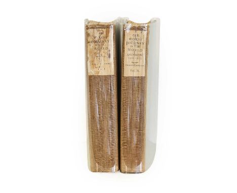
Cherry-Garrard (Apsley)The Worst Journey in the World. Antarctic, London: Constable and Company Limited, 1922. 2 volumes, 8vo, recent blue paper boards retaining original linen spines, half-titles, binder's blank to rear of volume 2, all plates and maps as called for (including the 10 folding panoramas), volume 1 with tipped-in slip annotated 'Inscribed by Apsley Cherry-Garrard, by request, October 14 1938' possibly in the author's hand, both volumes with fraying to spine-ends, endpapers renewed (with duplicate spine-labels tipped in), spotting to half-titles, volume 1 spine-label stained and abraded, with damp-staining to top margins of plates towards rear, folding panorama at p. 184 partly split along central fold, folding map at p. 194 spotted along fold, folding map at p. 294 with closed tear to one fold and nicks and damp-staining to fore edge, volume 2 with damp-staining to gutter of a few plates, closed tear to stub of folding map facing p. 542.Rosove 71.A1.First edition. 'Cherry-Garrard's book has often been referred to as the finest polar book ever written ... a monument immortalizing the [Terra Nova] expedition in the annals of Antarctic exploration and geographic exploration in general' (Rosove).
Lot 2181
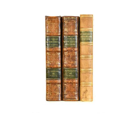
Scoresby (William). An Account of the Arctic Regions, with a History and Description of the Northern Whale-Fishery, 1st edition, Edinburgh: Archibald Constable and Co., 1820. 2 volumes, 8vo (206 x 130 mm), contemporary diced calf decoratively tooled in gilt and bllind, neatly rebacked with original spines laid down (labels possibly renewed), marbled endpapers and edges, 24 engraved plates and maps (of which 8 folding including frontispieces), 4 folding tables, front pastedowns with book-labels of William Leatham (possibly the banker and abolitionist, 1785-1842), half-titles and advertisement leaf discarded, plates variably spotted and damp-stained, frontispieces offset, folding general map with closed handling tear, together with:idem Journal of a Voyage to the Northern Whale-Fishery; including Researches and Discoveries on the Eastern Coast of West Greenland, 1st edition, Edinburgh: Archibald Constable and Co., 1823. 8vo (210 x 130 mm), near-contemporary olive-green half calf, 8 engraved plates and maps (4 folding), bookplates of William Willoughby Cole, 3rd Earl of Enniskillen (1807-1886) and of Lord Farnham, half-title discarded, plates and maps spotted, short closed tear in first map (within plate-mark but not affecting image), similar tear to inner fold of second map (qty: 2)Arctic Bibliography 15610 & 15614; Sabin 178167 & 78171.
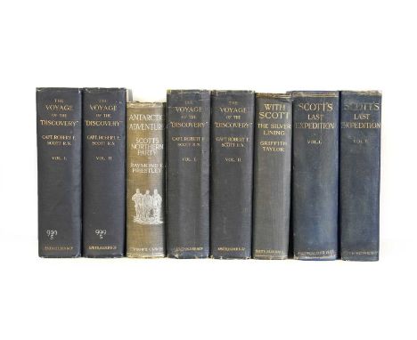
Lot 2182
Scott (Robert F.). The Voyage of the Discovery, 1st edition, 1st impression, London: Smith, Elder, & Co., 1905. 2 volumes, 8vo, original blue cloth gilt, top edges gilt, all plates and maps as called for, publisher's slip tipped to front pastedown, manuscript call-numbers in white ink to spines, old paper labels to upper inner corners of front covers, ink-stamps of the Manchester Guardian library to title-pages (cancelled verso), together with:Taylor (Griffith). With Scott: The Silver Lining, 1st edition, 1st state, London: Smith, Elder & Co., 1916. 8vo, original green cloth, penguin vignette to front cover, all plates and maps as called for, head of spine nicked, spotting to prelims and to folding map at rear,Priestley (Raymond E.). Antarctic Adventure. Scott's Northern Party, 1st edition, London: T. Fisher Unwin, 1914. 8vo, original blue cloth lettered and decorated in silver, all plates and maps as called for, spine faded and nicked, rear inner hinge cracked,and 2 others (another copy of The Voyage of the Discover, 1st edition, 1st impression, volume 1 shaken, and Scott's Last Expedition, 1st edition, 1916, these not collated) (qty: 8)Rosove 286.A1 a (Scott, Voyage), 324.A1 (Taylor), 256.A1 a (Priestley).

Lot 2183
Shackleton (Ernest H.). The Heart of the Antarctic. Being the Story of the British Antarctic Expedition 1907-1909, 1st edition, trade issue, London: William Heinemann, 1909. 2 volumes, 4to, original blue cloth, spines lettered in gilt, titles and vignettes to front boards in silver, volume 2 with the errata slip, all plates and maps as called for (including 3 folding maps and one folding panorama in end-pocket), spines sunned, chipped and nicked at ends, light cockling to covers, corners rubbed through and slightly bumped,[Brown, R. N. Rudmose, & others]. The Voyage of the "Scotia", being the Record of a Voyage of Exploration in Antarctic Seas. By Three of the Staff, 1st edition, Edinburgh: William Blackwood and Sons, 1906. 8vo, original grey pictorial cloth, all plates and maps as called for, spine rubbed as usual and slightly worn at extremities, pale mark to front cover, abrasion to rear, text spotted, ink-stamps of Cheltenham Public Library to one plate and folding map, deaccession stamp to rear free endpaper, folding map loose and crudely tape-repaired, plate facing p. 258 nicked in margins,Nordenskjöld (Otto). Antarctica, or Two Years amongst the Ice of the South Pole, 1st edition in English, London: Hurst & Blackett, Limited, 1905. 8vo, original green cloth, frontispiece, 5 colour plates, 4 maps (3 folding), spine nicked, covers slightly marked, closed tear to folding map facing p. 316,Priestley (Raymond E.). Antarctic Adventure. Scott's Northern Party, 1st edition, London: T. Fisher Unwin, 1914. 8vo, original blue cloth lettered and decorated in silver, all plates and maps as called for, binding rubbed, rear inner hinge loose,and 5 others (not collated), including Douglas Mawson, The Home of the Blizzard, Philadelphia: J. B. Lippincott, [1915] (2 volumes, 4to, original cloth), Levick, Antarctic Penguins, 1st edition, 1914 (8vo, original cloth) and similar (qty: 11)Rosove 305.B1 a (Shackleton), 50.A1 a (Brown), 240.A1 (Nordensköld), 256.A1 (Priestley).
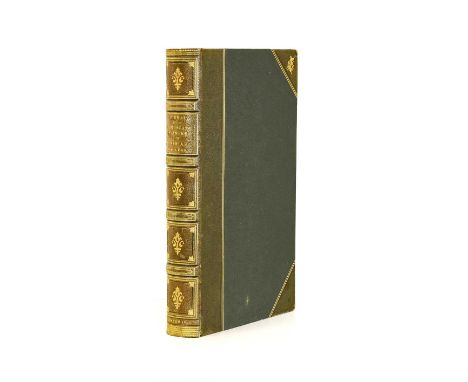
Lot 2185
Lear (Edward)Journals of a Landscape Painter in Albania, &c. Richard Bentley, 1851, first edition, frontis map, twenty tinted litho plates, marbled endpapers, all edges gilt, half green morocco gilt by Birdsall Owner's name to flyleaf, foxing to reverse of free endpapers, fly leaves, map and final leaf, offsetting from plates, corners rubbed and slightly bumped, backstrip lightly faded.
Lot 2186
Partition of India; Bangladesh; Pakistan. Collection of books and documents ex libris Sir Thomas Hobart Ellis (1894-1981), including:i) 'Fatik Bannerjee's Gang Case' [spine-title], typescript report by Ellis, approx. 150 ff. (rectos only), folio, contemporary half sheep,ii) Folder of typescript notes and correspondence and newspaper cuttings on the Multiple Allotments Act (1957), together with 5 folders of similar documents,iii) Manuscript notebook of N. L. Hindley, district judge, Tippera, 1933, approx. 50 ff., quarter roan binding, spine defective,iv) Ellis's degree certificate (BA, Queen's College, Oxford, 1920); certificate of appointment to Indian Civil Service, 1919; certificate of appointment as permanent Chief Justice of the High Court of East Bengal, 1953; certificate of appointment as governor of East Bengal during the absence of Iskander Mirza, 1954,v) A collection of approx. 50 gelatin silver print photographs, including individual portraits of Ellis and others, group portraits including High Court of Judicature at Dacca in East Bengal, 1954, a folder of aerial photographs,vi) Printed books, comprising:a) Ellis (Thomas Hobart). Report of Inquiry Against Mr M. A. Muqtadir, Additional District Magistrate, Dacca, in connection with the Adamjee Jute Mill Riots. Secret, Dacca [Dhaka]: East Bengal Government Press, 1951, folio, original wrappers, 38 pp.,b) Speeches delivered by His Excellency Chaudhry Khaliquzzaman ... Iskander Mirza ... Sir Thomas Hobart Ellis ... Mohammad Shahabuddin, Dacca [Dhaka]: East Bengal Government Press, 1954, 8vo, original quarter cloth, 112 pp.c) Report of the Indian Statutory Commission. Volume 1 - Survey [Volume 2 - Recommendations], Calcutta: Government of India Central Publication Branch, 1930, 2 volumes, 8vo, contemporary half sheep, folding maps (collation not established), ownership inscriptions of T. H. Ellis,d) Macdonald (David). Touring in Sikkim and Tibet, Kalimpong: published by the author, 1930, small 8vo, contemporary half sheep, Ellis's name gilt-stamped to spine and with his annotations to endpapers, lacking map, and one other similar (Percy Brown, Tours in Sikhim, 3rd edition, Calcutta, 1934, not collated),e) 'A Study of Christian-Muslim Relations in East Pakistan. Walter Bruce Davis, 1961', roneoed typescript, 51 ff., wire-stitched in wrappers,vii) Other items, including 3 watercolours, a visitors' book titled on cover 'Ellis Arms', a commonplace book dated 1877, function invitations, banquet menus, and similar (qty: a carton)Thomas Hobart Ellis (1894-1981) was Chief Justice of the East Bengal High Court, and served as acting governor of East Pakistan (modern Bangladesh) in 1954 during the absence of Major-General Iskander Mirza.

Lot 2187
Ross (James Clark)A Voyage of Discovery and Research in the Southern and Antarctic Regions, during the Years 1839-43, London: John Murray, 1847. 2 volumes, 8vo, original vertical-ribbed blue-green cloth, titles to spines and pictorial vignettes to front boards gilt, 8 tinted lithographic plates including frontispiece and folding panorama (tissue-guards), 8 engraved charts and plans (3 folding), 17 chapter-headings with wood-engraved vignettes, 16 pp. advertisements dated October 1847 to rear of volume 2, spines consolidated at head and foot, inner hinges neatly strengthened, variable spotting to volume 1 frontispiece, plate facing volume 2 p. 169, and folding map at rear of each volume, folding map at rear of volume 2 with closed handling tear repaired verso, ownership inscriptions and a few marks to endpapers.Rosove 276.A1 c.First edition, 'a cornerstone of Antarctic literature and a monument to one of mankind's greatest expeditions of geographical and scientific exploration' (Rosove), one of 1,500 copies printed. The expedition also visited the Crozet Islands, Kerguelen Island, Tasmania, Australia, New Zealand, Campbell Island, and the Falkland Islands.
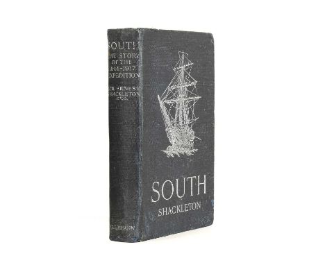
Lot 2188
Shackleton (Ernest H.)South: The Story of Shackleton's Last Expedition, 1914-1917, London: William Heinemann, 1919. 8vo, original dark blue cloth lettered and decorated in silver, recased, all plates as called for, folding map, binding rubbed, corners bumped, errata slip discarded, text-block toned as usual, spotting to a few leaves adjacent to plates, plate facing p. 8 nicked along fore edge, pp. 351-61 clumsily opened along fore edges, folding map with neatly repaired closed tear to stub not affecting image, small hole in front free endpaper, a few other minor nicks and marks.Rosove 308.A1.First edition, first impression. 'Shackleton's account is a classic and one of the finest in the Antarctic literature. With his inimitable style he chronicled a great tale - an epic of leadership, loyalty, and survival' (Rosove).

Lot 2190
BradshawBradshaw's Railway Time Tables, and Assistant to Railway Travelling, with illustrative Maps and Plans, 10th Mo. 25th, 1839 (No. 3), [though possibly the 1889 fifty year facsimile], includes folding map of England and Wales, four double page maps, town plans of Birmingham, Liverpool, Manchester and Leeds and timetables and fares, original covers with label to upper board.


Lot 175
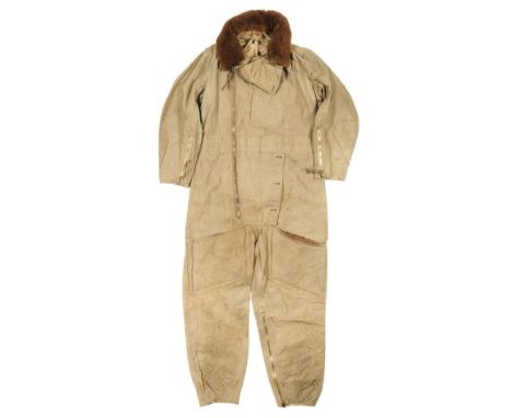
Flying Suit. A WWII Battle of Britain period 1930 pattern "Sidcot" flying suit belonging to Sergeant Thomas William Townshend, 601 Squadron, who served in Blenheims before moving to Hurricanes during the Battle of Britain, the lightweight waterproofed green cotton, with lined lining, full length diagonal zip front, zip sleeves and legs, large flap collar and detachable fleece collar, large map pocket to the left breast, two large fleece lined pockets to each thigh, the inner collar stamped in black in FP 10 39 and the hanging strap inscribed Townshend 801555, the detachable collar also inscribed 801555, and stamped in black ink A.I.D. I.P2, A.M. 3, 148cm long QTY: (1)NOTE:The 1930 pattern flying suit was a direct development of the WWI Sidcot suit and could be worn with full service uniform. It was used throughout WWII.801555 Sergeant Thomas William Townshend was born in Edmonton, Middlesex in 1918, he was educated at St James School before joining 601 Squadron, Auxiliary Air (Aircraftsman). He was recalled for service on the outbreak of WWII and advanced to an Air Gunner. In February 1940 the squadron exchanged its Blenheims for Hurricanes and its Air Gunners were posted away. Townshend joined 600 Squadron in May when it was replacing aircrew killed on a raid on Waalhaven on 10 May. He served with 600 Squadron throughout the Battle of Britain. Townshend shot down a Me110 on 14 August 1940. The enemy aircraft had been part of Erprobungsgruppe 210, a specialist fighter-bomber unit that was tasked for raids on Ramsgate and Manston airfields. In an interview, Townshend recalled "I grabbed the mounting with the four Brownings fixed to it and had the leader of the nearest formation to me in my sights. Both lines of the formation swept past between myself and the hangars. They were that close that I still think today that I could have thrown a stone and hit one or other of them. As it was, I opened fire and to my utter amazement watched a row of bullet holes ripping through the port wing right along the aileron section, the bullet holes travelling towards the fuselage... I had fired in the region of 250-300 rounds.Vasco (John J) 'Bombsights Over England: A History of Eprobungsgruppe 210' refers.

Lot 182
Flying Suit. A WWII RAF 1940 pattern "Sidcot" flying suit (size 7), the heavy olive garbadine type fabric with original label stamped with stores reference number C.No. H174187/40.C.I.d., inscribed in black ink WD 152, full length diagonal zip front, zip sleeves and legs, large flap collar, large map pocket to the left breast, two large pockets to each thigh, 170cm long, together with a WWII RAF 1941 pattern electrically wired flying suit (size 6), with Air Ministry tailor's label stamped 22C/778, inner collar inscribed with owners service number 1853153 each with an associated detachable fleece collar plus a quilted kapok liner (used with both the 1940 and 1941 pattern flying suits), the tailors label with stores reference number 22C/855 and additionally inscribed with the service number 1815564?, the leg zip inoperable and a fur-fabric "teddy bear" inner suitQTY: (4)

Lot 194
RFC/RAF. A collection of badges, including six RFC brass cap badge, RCAF brass cap badge, RNAS cap badge by J.R. Gaunt, 2 RAF Dental Branch badges, RFC plated cigarette case (damaged), cloth badges, silk escape map for Northern Europe with original map case and SOE escape compass, 2 bomb split pins and other itemsQTY: (35)


Lot 216
Flying Suit. A WWII Battle of Britain period 1930 pattern "Sidcot" flying suit, the lightweight waterproofed green cotton, Air Ministry black ink stamp and label stamped G.B.C. 27232, Size 5, C.998456/39/C.I.B. 1939, with cloth lining, full length diagonal zip front, zip sleeves and legs, large flap collar, large map pocket to the left breast, two large fleece lined pockets to each thigh, 165cm longQTY: (1)
Lot 35
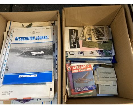
Aircraft & Civil Defence Memorabilia. A large archive of memorabilia assembled by ROC Officer D.H. Taylor, 8 Section No. 2 Crew, based at RAF Gaydon, including a group of 8 large Ministry of Aviation aircraft silhouette posters, c. 1950s, including Vulcan B Mk 1, Sea Vixen FAW Mk 1, Comet Mk 4, Vulcan B Mk 1, 5 Episcope packs of aviation silhouette cards, a set of 6 photo postcards showing inside the Civil Defence school 'the Hawkhills', Manual of Civil Defence: Volume 1 'Nuclear Weapons', published by HMSO, 1956, 2 'Operations Room Training Aid' booklets, 1960s, a large war room map showing the world as double hemisphere, Coventry ROC No. 5 Group plotting chart, Aircraft Armament Past and Present, Parts 1 & 2, published Real Photographs Company Ltd, a group of approximately 60 journals from ROC Gaydon (1952-1971) including 51 x Joint Services & ROC Recognition Journals, a collection of personal effects belonging to D.H. Taylor, including ATC soft blue cap (inside dated 1964), black tie, ATC Cadet's flying log book, gold cloth badge, belt, etc., plus a further assortment of mostly printed booklets, documents and ephemeraQTY: (2 cartons)NOTE:Much of the material is marked 'Restricted' or 'Confidential' and reflects the classified nature of the work undertaken by the Ministry of Aviation personnel at RAF Gaydon during Britain's early Cold War period.
Lot 386
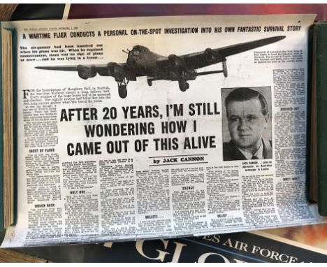
Posters and prints including Stu Francis Crackerjack Roadshow poster, Return of the Heroes Print Spitfire by Ivan Berryman, Vintage Picture Map of London by Francis Chichester, posters of the Magna Carter and British Museum Translation of. Dambusters Print after Alan Roe, 'Dam Buster VC', signed by 2 members of the squadron and the artist, limited edition 74/250 (42cm x 59cm), a Royal Navy Guide to the Fleet Poster and USA Globemaster III airplane poster (tear at left) and photocopy of a newspaper story (9)
Lot 432
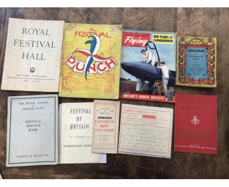
Festival of Britain ephemera: the Royal School of Church Music Festival Service Book VGC and 1951 Royal Festival Hall Souvenir Programme - Ceremonial Opening and Inaugural Concerts 3 May - 9 May 1951 in good condition and Commemorative Poster Stamps Sold in Aid of The Greater London Fund for the Blind, 2s6d in VGC and Edition of Punch magazine, good condition and 1951 Festival of Britain Cable & Wireless Telegram Souvenir Message via Imperial and 1951 Festival of Britain Information Summary Mar 3rd - Sept 30th published by HMSO and "News Chronicle" London Map and Guide, full colour, 1951 News of the World Almanac and Household Guide, good and Royal Air Force 'Flying Review' Magazine September 1955 with an exclusive on Britain's Guided Missiles, cover showing Folland's Gnat. VGC


Lot 1052
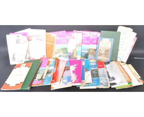
A collection of vintage 20th century O.S (Ordnance Survey) British maps. The lot to include maps or varied areas and scales, some also mounted on cloth. Including Ordnance Survey On-inch map of Great Britain Torquay, scale one inch to one statute mile 1/63360, Ordnance Survey Oxford & surrounding area, scale 2cm to 1km, RAC South East, including maps of London, Brighton, Canterbury, Dover, Portsmouth, Folkestone, Windsor, scale 3 miles to 1 inch, and more.


-
109182 item(s)/page