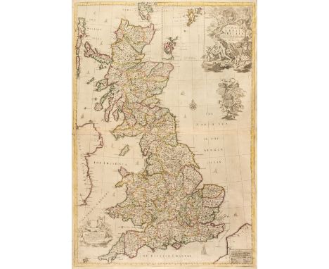
Cornwall. Kip (William), Cornwall olim pars Danmoniorum [1610], hand-coloured engraved map, large inset vignette of Launceston, narrow vertical margins, 305 x 400 mm, together with Blome (Richard). A Mapp of the County of Cornwall with its Hundreds [1673], hand-coloured engraved map, several repaired marginal closed tears, some affecting the printed image, 240 x 310 mmQTY: (2)
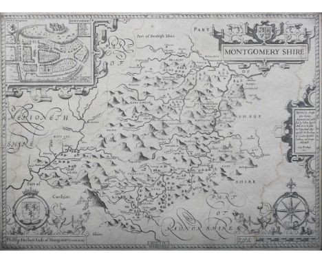
We found 109182 price guide item(s) matching your search
There are 109182 lots that match your search criteria. Subscribe now to get instant access to the full price guide service.
Click here to subscribe- List
- Grid
-
109182 item(s)/page
Sultan Jahan Begam (Nawab, Her Highness). An Account of My Life, 2 volumes, 1st editions, John Murray, and Bombay: The Times Press, 1910 and 1922, volume I translated by C.H. Payne, volume II by Major Abdus Samad Khan, both volumes signed by the author at the front, and dated 2 10 22, each volume with portrait frontispiece, one map and numerous plates, letterpress toned, volume I with foxing mainly affecting fore-edge and upper margins, top edges gilt, original blue cloth gilt, spines darkened, extremities rubbed, scarce minor marks, volume I spine with small dent and rear cover with few small wormholes (two affecting letterpress), 8voQTY: (2)NOTE:A scarce set. No other examples have been found signed by Sultan Jahan Begam.
British Isles. Senex (John), A New Map of Great Britain, Corrected from the Observations communicated to the Royal Society at London, 1728, engraved map with contemporary outline colouring on two conjoined sheets, inset map of the Shetland and Orkney Islands, large uncoloured cartouche, surmounted by a portrait of Queen Anne, several repaired marginal closed tears, slight staining, 940 x 645 mm, together with A New Map of England from the latest Observations by John Senex..., [1721], engraved map with contemporary outline colouring, large uncoloured allegorical cartouche, 510 x 600 mmQTY: (2)NOTE:R. W. Shirley. Printed Maps of the British Isles 1650 - 1750. Price 2. state 5 (Imprint now reads John Senex F. R. S. and although the map is still dated 1714, Senex became a fellow of the Royal Society in 1728). All reference to Charles Price is now removed. The second item. Senex 3. Only one known state.
Ensak (designer) – ‘Philips Radio, the World of Entertainment’ (Philips Radio Map), mid-20th century lithograph in colours, printed by Kühn en Zoon, Rotterdam, sheet size 72cm x 104cm, together with two 20th century hanging wall charts, ‘Europa, Kultur’ by Georg Westermann and ‘Tiere der Kreidezeit II’ by Heinz Dost.
Emmanuel Bowen – ‘An accurate Map of Devonshire divided into its Hundreds’ (Map of the County of Devonshire), 18th century copper engraving on laid paper with later hand-colouring in outline, published by John Tinney, 52cm x 67cm, within a Hogarth style frame, together with a map after Thomas Kitchen, ‘A New Improved Map of Cornwall’.
A 22ct gold Battle of Britain 25th Anniversary commemorative medallionlimited issue numbered 310 by Toye, Kenning & Spencer Ltdtwo fighter planes with search lights over a map of England and Wales Battle of Britain Sept 1940 rev. 'Never in the field of human conflict was so much owed by so many to so few', accompanied by certificate diameter approx. 52mm., weight approx. 91.2gCondition: Fine
London. Cruchley's New Plan of London improved to 1830an engraved dissected map in thirty six sections, backed on linen and with hand colouring, London, G.F Cruchley, marbled green endpanelsoverall 54 x 138cmCondition: Uniform toning. Linen wearing through on some folds and corners. far right mid section has worn through on side and top fold.
A 22ct gold Battle of Hastings 900th Anniversary Commemorative two medal set issued by Spink & Son Ltdlimited edition numbered 66, each William the Conqueror seated facing holding sword and globe under an arch, 'William the Conqueror 900th Anniversary, rev map of Normandy and Southern England with four ships crossing the channel, The Last Invasion of Britain, 1066, The Battle of Hastings, accompanied by certificate, (2)first diameter approx. 58mm., second diameter approx. 39mm., total weight approx. 184.8gCondition: Fine. Certificate damaged by damp
London. Bowles's Reduced New Pocket Plan of the Cities of London and Westminster, with the Borough of Southwark, exhibiting the New Buildings to 1797and engraved dissected folding map in sixteen sections, backed on linen and with hand colouring, London, Bowles and Carveroverall 56.2 x 39.5cm.Condition: Uniform toning. Linen wearing through on some corner folds. Some staining north of Holborn
A 22ct gold Battle of Britain 25th Anniversary commemorative medallionlimited issue numbered 310 by Toye, Kenning & Spencer Ltdtwo fighter planes with search lights over a map of England and Wales Battle of Britain Sept 1940 rev. 'Never in the field of human conflict was so much owed by so many to so few', accompanied by certificate diameter approx. 39mm., weight approx. 42.2gCondition: Fine
De Bry (Theodor) IX Expurgnatio Civitatis S. Augustini In America Sitaea copper engraved map c.1600 with wash colouring, Latin text below Based on Boazios map of 1589 this engraving illustrates the attack of St Augustin by Franicis Drake on the settlement on May 28 and 29, 1586. from de Bry's Grand Voyages, 1599, (America Part VIII), mounted framed, within mount 19.3 x 21.5cm.Condition: Cropped. colouring most likely later. water mark bottom right
London. Lewis, (Samuel) A plan of London and its Environs shewing the Boundaries, shewing the Boundaries of the Cities of London and Westminster, Metropolitan Boroughs and Parishesan engraved dissected map in forty five sections with hand colouring, London, S Lewis & Co. c.1851, gilt tooled fine grain red morocco95 x 113.5cm.Condition: Map overall good some discolouration top right hand section where its basted to boards. Both boards with wear, staining. Front hinge cracking. Corners bumped. Top edge of spine dog earred
Thames. Ravenstein's Oarsmen's and Anglers Map of the River Thames from its source to London Bridgea concertina style folding map backed on linen with hand colouring to river, c.1880, label for James Wyld, London, embossed cloth with paper label overall 15.8 x 260 cmCondition: Some old wormholes to first and second leaf. Occasional marks, small loss and tear to another
Box of assorted items to include: vintage cream crochet woollen blanket with 'Tranquilitie Valcel' label, circular two handled trays, loose cutlery, small wooden mounted wall barometer, etchings of 'Croome House, Worcestershire' and 'Manorbeer Castle', a coloured map of Worcestershire, Celtic recipe book etc. (B.P. 21% + VAT)
Bound volume of 'The Captain Magazine', 'Foxes Book of Martyrs' in quarter calf with marble boards, Conrad, Joseph 'The Secret Agent', published by Methuen & Co. second edition, two volumes ' The Royal Magazine, or Gentleman's Monthly Companion' from the 18th century in full calf, Bickerstaff, Isaac 'The Lucubrations Of' Volume Three. 'Scenes in Europe for the Amusement of Instruction of Little Tarrier Town Travelers', by the Reverend Isaac Taylor, eight edition 1825. (B.P. 21% + VAT) Image of map added.
A collection of military and aviation ephemera, including a scarce LZ 127 Graf Zeppelin postcard booklet, containing two real photographic images of the airship, a collection of aerial reconnaissance views, dated '10.10.1918', within a later cloth-bound album, detailed 'Lieut John Wells', who was a pilot with 99 Squadron, two late 1930s battlefield tour booklets for Aisne and Marne with pull-out maps, and a Whitehall Series military map of the Virginian Campaign 1861-3 American War of Secession.
A First World War period cloth-backed printed map of Ypres, Edition 3A, 'Trenches corrected from information received up to 19-5-18', together with three silk escape maps, comprising Norway, North Africa and Egypt, a Second World War period medal pair, comprising War Medal and Defence Medal, and a small group of other ephemera.
ink and colour on paper, framed and glazed, image 62 by 53cm Footnote: In 1708-1716, the Kangxi emperor ordered a surveying of China. A copy of these surveys were sent back to Paris and the Royal cartographer D' Anville was commissioned to draw this map, which was the first really reasonably accurate picture of that remote land.
Maps of Europe - Kingdom of Italy Large detailed double page map with several insets from 'The Royal Illustrated Atlas, of Modern Geography' published by A. Fullarton and Co., London and Edinburgh 1860, good condition with minor edge foxing, France and Its Principal Foreign Possessions By G.H. Swanston. Edinr. With seven inset maps. XLIV. Eng'd. by G.H. Swanston Edinr. A. Fullarton & Co. Edinburgh, London & Dublin, 1872. 19 1/2"x 22" in good condition with some minor foxing to the edges and England & Wales by G.H. Swanston, Edinr. XXV. (with) Scilly Islands on the same scale. Eng'd. by G.H. Swanston, Edinr. A. Fullarton & Co. Edinburgh, London & Dublin.
LEATHER BINDINGS. WRIGHT, Thomas. The History, Gazetteer and Directory of the County of Essex..., Sheffield & London 1863, lacks county map, full calf, rebacked; GOSTLING, W. A Walk in and about the City of Canterbury with many Observations, Canterbury: Simmons and Kirby 1779, third edition, title printed in red and black, engraved pictorial headpiece and folding map; [POCOCKE, Capt. Thomas]. Journal of a Soldier of the 71st, or Glasgow Regiment, Highland Light Infantry, from 1806 to 1815, Edinburgh: Balfour & Clarke for William and Charles Tait and others 1819, 2nd edn; CERVANTES, Miguel. Don Quixote, London 1811, 4 vols; and others in sets, part sets and single vols as called for, full, half or quarter leather, sm 8vo (41)
DE LA BECHE, Henry T. Report on the Geology of Cornwall, Devon and West Somerset, London: Longman, Orme, Brown, Green and Longmans 1839, first edition, rebound in quarter black morocco with gilt embossed title to the spine. folding map/plan plates at the back of work, tears to plates, browned title page
DEVON. GREENWOOD, C. & J. Map of the County of Devon from an actual Survey made in the Years 1825 and 1826..., July 4th 1829, hand coloured engraved map, inset map of Lundy Island, calligraphic cartouche, compass rose, table of reference and an uncoloured vignette of Exeter Cathedral, 65cm x 74cm
NANSEN, Fridtjof. Farthest North, London: Newnes 1898, 2 vols. illust. inc. large folding map at rear of vol. 1, org. pictorial cloth, fairly clean copies, 4to; iDEM. The First Crossing of Greenland, London: Longmans 1892, new edn.,illus. from photographs and engravings, orig. pictorial cloth, damp stained, 8vo (3)The first is the first English edition from the Norwegian
AFRICA. ANON. an engraved plate from an 18th century publication showing a prospect view of Cape Town, a plan of the castle and a view of Table Bay, 29cm x 37cm; CRÉPY, Jean-Baptiste, L'Afrique, hand coloured map, 1767, 23.5cm x 30cm; and PETRI, Otto. Afrika, hand coloured map, 1848, foxed, 23cm x 298cm (3)
-
109182 item(s)/page