We found 109198 price guide item(s) matching your search
There are 109198 lots that match your search criteria. Subscribe now to get instant access to the full price guide service.
Click here to subscribe- List
- Grid
-
109198 item(s)/page


Lot 191
HUTCHINSON WILLIAM. The History of the County of Cumberland. 2 vols. Eng. plates, plans & illus. Quarto. Nice rebound brown morocco, marbled brds. Carlisle, 1794.Condition report:VOL. 1 - No County map. rest of plates as called for.VOL. 2 - Vol. 1 frontis and pictorial title page. Pieced title. Facsimile map Whitehaven.Workington plan foxed, browned with some splits. 2 x Pocklington's Island (one in text, one folding).Map of Carlisle repaired with tape."2 Views of Carlisle" - One view only.Last 2 plates listed in Vol. II (Fish & Egg) in Vol. 1.


Lot 237
HUTCHINSON WILLIAM. The History of the County of Cumberland. 2 vols. Eng. plates, unusually some being hand coloured. Quarto. Rebound. Carlisle, 1794.Condition report:Vol. 1 - Frontis bound in p. 53.Misprinted pages/bound in out of sequence. p. 50 - 55.Maps of roads and Ullswaters bound out of sequence p.63. Vol. 2 - No plan Whitehaven. Hole in page 45.P. 251 repairs.No plate Cockermouth Castle and Bridekirk font (p. 254). No map Carlisle.2nd view of castle tipped in.One view of Carlisle Castle only. p. 597.No view of "Carlisle Castle from Catcoat Bank" p. 657.
Lot 5
RENNELL MAJOR. The Marches of the British Armies in the Peninsula of India during the Campaigns of 1790 & 1791. Fldg. eng. map & 3 fldg. eng. diags. Calf. 1792; also 2 vols. only of (Robert Orme), A History of the Military Transactions of the British Nation in Hindostan from the Year MDCCXLV, vol. 1 complete with Books I to V & 10 fldg. & other eng. maps as called for, vol. 2 containing Books X to XIII & 9 fldg. & other eng. maps, quarto, mottled calf, 1763 & 1778. (3). Condition report:Rennell - Slight wear to calf and slight splitting to top of spine. Some old repairs to back board. Slight splitting to inside front and back boards. Browned end papers, title and first few pages of text. Text generally good and clean. Slightly undulate paper Folding map good with v. small tear where bound in and slight off setting/v. light foxing. Folding plans of army lines good, v. slight browning, as images. Ormes. Vol. 1 1763 - Rebacked with original boards.Foxing/browning throughout. Maps/plates as called for. Small hole in Plan of Country near Trichinapoly. Binding sound.Ormes Vol. 2 1778 - Later edition? Vol 2, 1st vol. plate list does not correspond with Vol. 1 present. Text generally cleaner than Vol.1 but still foxing and browning throughout.Small tear Carnatic Map.Small tear Madras.Small tear Plan of Fort St. George.Small tear Carangoly.Small tear Permacoil.


Lot 321
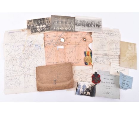
WW1 Paperwork & Photograph Grouping of Sergeant H T Grigg Queens Westminster Rifles, all housed in a original canvas writing folder case with his details pencilled to the inside. Various paperwork and Trench map etc. Quantity of postcard photographs, cap badge and an Allied Victory medal awarded to “28795 CPL D C R HUMBY RE”.


Lot 549
Five large wall hanging map board of areas of The United Kingdom, featuring Glasgow and The Scottish Highlands, (1) The Bristol Channel, Cornwall and Devon, (2) Wales and The Midlands, (3) London and The South-East (4) and The North East (5) each measuring 84 x 112 cm, each marked verso 'Trantor (Tractors) International Ltd.


Lot 392
A John Speed Issue of 1614 map of 'Saxon Heptarchie', possibly early colour, 40 x 50cm, framed and glazed with glass to either side. CONDITION REPORT Some staining to the type on the back of the map and some minor repairs. Age related wear, some slight thinning of area where map has been folded, very small hole to the top of border in centre, some age related discolouration to the script verso, particularly to the margin.

Lot 394
After William Blaeu; 17th century map of Europe, 'Europa Recens Descripta a Guiliermo Blaeuw', later hand coloured, with central fold and watermark lower right, 40.5 x 56cm, framed and glazed. CONDITION REPORT On wove paper with plate marks and fold, appears genuine, later colouring , as expected. some yellowing, water stain to the lower right corner and central right margin,


Lot 399A
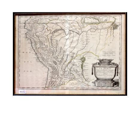
Two 17th century maps, one by Nicholas Sanson c1656 entitled 'Le Pérou et le Cours de la Riviere Amazone' with hand-coloured borders in greens and yellows and a Willem Janszoon Blaeu c1630 map of Perv (Peru) with hand-coloured land borders in greens and polychrome hand-coloured decorative cartouche to the top-left, 38 x 49cm, each in Hogarth frame and glazed, an 18th century map of Peru and two 19th century examples to include an 1818 John Pinkerton map of Peru with magnified cutaway of the coast by Bishop, an 1828 Sidney Hall map of Peru with land borders coloured in pink and yellow and a 1764 Jacques Nicolas Bellin map entitled 'Suite du Perou Audience de Charcas', hand-coloured in yellow border with pink land borders and polychrome hand-decorated cartouche to the lower-left, notation to the top corner border 'Tome II No 75', approx 23 x 31.5cm, all in Hogarth frames and glazed (5). CONDITION REPORT Sanson map with pale stripe and some minor creasing by the fold, the other with significant vertical creasing by the centre fold and pale patch to the corner, both with pencil prices lower left.
Lot 400
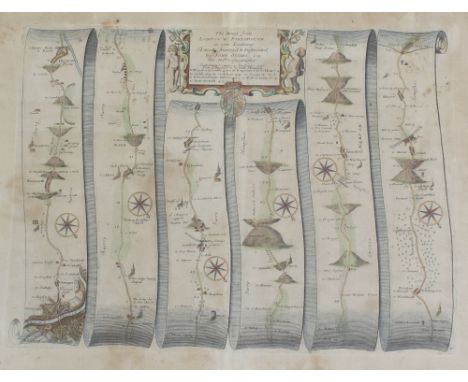
A 17th century map of the road from London to Portsmouth by John Ogilby, with later hand colouring, 33 x 43.5cm, in verre églomisé glazed gilt frame, a John Boydell 18th century hand-coloured engraving describing the West prospect of the City of Oxford, published 1751, an 18th century optical print of Port de Constantinople by J Chereau, published Paris c1750 and a further map of the County of Oxfordshire, originally published Temple Bar 1758, this a later example, approx 21 x 18.5cm, in Hogarth frame and glazed (4).
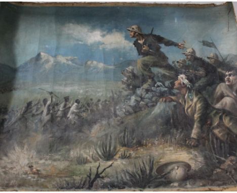
Lot 439
UNATTRIBUTED; oil on canvas, military scene of soldiers on rocky outcrop and marauding soldiers below, 66 x 89cm, with earlier portrait verso, unframed, a Geographia Ltd linen map of Columbia, various other maps to include maps of the Mediterranean and the United States and two military triptych photographs documenting the funeral of Major Thomas Irvine, who served in the 91st Argyle and Sutherland Highlanders in South Africa 1899-1902 and was in the battles of Modder River, Magers Fontein and Paareberg, he was mentioned in dispatches and received the Queen's Medal and clasps fore the aforementioned battles, The Illustrated London News Special: Coronation of King Edward VII 1902 edition and Lord Byron; a tale, 'Lara' illustrated by C B Birch.

Lot 505
A box of oak military plaques, an Argyle and Sutherland military bugle, a Masonic bell with wall bracket, a school hand bell, a handmade trench art hand bell with a map of the Falklands and marked 'Bromborough Royal British Legion Club' to one side and 'Falkland Islands' beneath the map, height 27cm, a Merseyside Police helmet badge and two hat badges.
Lot 509
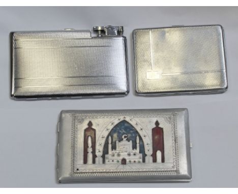
A WWII period cigarette case decorated to one side with mosque with crescent and to the other with a map of Africa, an early/mid-20th century Sylva chrome-plated cigarette box with engine-turned covers and a Polo combined cigarette case and lighter, also with engine-turned case, width 14cm (3).
![Robert Morden (c.1650 - 1703), by, two-page map, Darbyshire (sic, Derbyshire), [Published and] Sold by Abel Swale, Awnfham (s](https://cdn.globalauctionplatform.com/e5c027d6-14f6-4a75-821a-aa9a00b24461/e1581ccc-1250-4511-aa2c-aa9d007c4d3e/468x382.jpg)
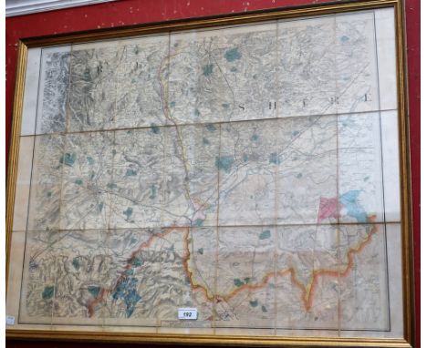
Lot 192
Benjamin Baker (second-quarter, 19th century), after, a twenty-one fold map, of the border of Derbyshire, Nottinghamshire and Leicestershire, Published at the Ordnance Survey Office, Tower of London, 8th Feb:y 1836 by Lieut. Colonel Colby, Royal Engineers, Sold by Letts, Son & Co, 8, Royal Exchange, [London] E.C [...], Agents by Appointment for the Sale of Ordnance Maps, engravings laid on canvas, hand-coloured delineations, 63.5cm x 82.5cm


-
109198 item(s)/page