We found 109182 price guide item(s) matching your search
There are 109182 lots that match your search criteria. Subscribe now to get instant access to the full price guide service.
Click here to subscribe- List
- Grid
-
109182 item(s)/page

Lot 2089
[MUILMAN, PETER]. A New and Complete History of Essex, 6 vols., 1770 - 69 - 72. 8vo., cont. calf with green and red spine labels gilt. Engraved titles in vols 1 - 3. Engraved folding county map (defect to cartouche at inner edge) and plates (lacks plates of Dynes Hall and Earl`s Colne Priory, 3 other plates defective, 2 torn). Bookplates of W. Doubleday, Coggeshall, and R.G. Hollies-Smith. Sold not subject to return. (6)

Lot 2090
PLOT, ROBERT. The Natural History of Oxfordshire, Second Edition, Oxford 1705. Folio, cont. panelled calf (old reback with orig. backstrip laid down, endpapers renewed, lower joint cracking. Folding engraved map and 16 plates. 18th c. name "D: Rich..." on recto of first blank and 2 lines of notes on final blank in the same hand. See illustration.
Lot 2095
SMITH, Rev. A.C. Guide to the British and Roman Antiquities of the North Wiltshire Downs...Published by the Marlborough College Natural History Society, 1884. 4to., orig. cloth gilt (rather shaken, front inner joint broken and flyleaf loose). Double page map, coloured in outline, plates and text illustrations. With another on Wiltshire. (2)
Lot 2096
SMITH, WILLIAM. A New and Complete History of the County of Warwick. Birmingham, 1829. Cont. calf gilt (lower cover detached, one index leaf loose with small tear). Engraved map and plates (spotted) - WEST, WILLIAM. Picturesque Views...in Staffordshire & Shropshire. 2 vols. in one, Birmingham 1830 - 31. Orig. cloth backed boards (soiled, spine worn). Engraved views after Frederick Calvert (spotted). With vols. 1 & 2 only of Morris. A Series of Picturesque Views of Seats...Leeds, n.d., orig. cloth. Colour plates. All 4to. (4)

Lot 2112
COGAN, THOMAS. The Rhine: Or, A Journey from Utrecht to Francfort... 2 vols., Printed by G. Woodfall 1794. 8vo., cont. tree calf (spines rubbed with wear to labels). 24 aquatint plates, folding engraved map and 3 folding plates of music (a few plates spotted in margins). (2) See illustration.
Lot 2125
RUSSELL, HENRY STUART. The Genesis of Queensland, Sydney 1888. Portrait frontispiece. Three folding maps (one with marginal tear), and folding facsimile, (spine, defective, one contents leaf loose) -- BADEN-POWELL, GEORGE S. New Homes for the Old Country..., 1872. Plates and text illustrations, (spine chipped, covers slightly faded) -- EDEN, CHARLES H. My Wife and I in Queensland, 1872. (spine faded). Frontispiece and folding coloured map. -- WEEDON, THORNHILL. Queensland Past and Present, Second Issue, Brisbane 1898 (spine faded and torn, covers soiled, inner joints broken). Folding coloured map, photographic illustrations. 8vo., orig. cloth. First three titles with signature or bookplate of Sir Arthur Hodgson. With 16 others on Australia. (20)
Lot 2145
ARROWSMITH, JOHN. Australia From Surveys Made By Order of the British Government...1st June 1862. Folding engraved map, hand coloured in outline, linen backed, in orig. green morocco gilt slipcase (rubbed, flap splitting). 660 x 885 mm. with lithographic map of Queensland, Under the direction of W. Alcock Tully, 5 sheets (ex 6) 3rd issue Brisbane, 1885.

Lot 2151
CHAPMAN, JOHN and PETER ANDRE. A Map of the County of Essex. 1777. Folio, old half leather with red morocco gilt label on upper cover, by Sotheran, 26 double page sheets, including title, list of subscribers, and key map, all hand coloured (key map with crease). Bookplate of R.G. Hollies-Smith. Inscription on verso of front flyleaf by the Rev. W. Greenhill of Farnham Rectory, Essex, noting the presentation of the volume to him by the surviving son & daughters of the late Dr. Burford, Vicar of Pelham Furneux Herts, on 12th July 1831. "I read ye Burial Service over ye Body of Dr. Burford`s Eldest son...i.e. ye same year I performed that Melancholy Service over ye Father...". See illustration.

Lot 2153
DONN, BENJAMIN. A Map of the County of Devon, With the City and County of Exeter. Printed for the Author, 1765. Folio, modern qtr. green morocco, marbled board sides. 12 double page engraved sheets, 11 of them hand coloured in outline (some offsetting). Bookplate of Edward Lynam, 1945. See illustration.

![JENICHEN, BALTHASAR. Nova Totius Palestinae seu Terrae Sanctae Descriptio Pagella..., [Nuremberg 1570]. Overmounted, framed a](http://lot-images.atgmedia.com/SR/10083/2863441/2156-2012621112611_468x382.jpg)
Lot 2158
LAURIE & WHITTLE, pub. The Empire of China, With Its Principal Divisons; Drawn from the Surveys made by the Jesuits: with Improvements and Additions from the Maps of Monsr. D`Anville. 1794. Engraved map, hand coloured in outline, 480 x 620 mm. With another of Tartary from Thomson`s New General Atlas, Sept.1st 1814. Both unframed. (2)
Lot 2160
MORDEN, ROBERT. England. Sold by Abel Swale Awnsham and John Churchil, n.d. [1695]. Engraved map, hand coloured in outline with coloured title cartouche (tear to lower margin at centrefold). Framed and glazed. 384 x 428 mm. (to edge of frame). With another Morden map of Norfolk, engraved by John Sturt. (2)


Lot 2168
SPEED, JOHN. The Theatre of the Empire of Great Britain, Thomas Bassett and Richard Chiswell, 1676. Folio, disbound. Without A Prospect of the most famous Parts of the World. Engraved title and frontispiece (stained), 67 double page engraved maps (lacks Cardiganshire) but with additional map by Jansson: Scotia Provintiae. Generally in rather poor condition, approx. 12 maps torn, mostly at centrefold, approx. 12 wormed at centre, worst affected: Kingdom of Great Britain & Ireland, Dorset, Devon, Cornwall, Somerset and Wiltshire. Condition mainly improves from No. 25; three Irish maps and Invasions of England stained; creasing. Sold not subject to return. Chubb XXVII.
Lot 2217
STRUTT, JACOB GEORGE. Sylva Britannica..., Published for the Author [1830] 4to., cont. half green morocco gilt (upper cover almost detached). Engraved plates on india paper mounted (some spotting) -- GILPIN, Rev. WILLIAM. Remarks on Forest Scenery... 2 vols., Edinburgh 1834. 8vo., modern half green morocco. Engraved plates (lacks map). With 2 other volumes. (5)

Lot 2275
FUNCK, JACOB and MARC GUERARD D`ILLENS. Plans et Journeaux des Sieges de la Derniere Guerre de Flandres..., Strassburg 1750. First Edition. 4to., cont. calf (worn, spine defective). Folding engraved map and 24 folding plans, partly hand coloured. Woodcut ornaments (title stained at head). See illustration.
Lot 2283
[HOLY BIBLE, The, ? Deputies of Christopher Barker 1591] Black letter. Folio, old pale grey calf (soiled). Woodcut initials and ornaments, map of St. Paul`s travels. (lacks title A1, A4 defective, A6 defective, lacks B6 and Ffff3 & 4 [title to N.T.], Hhhhi torn, ends at Xxxxi). Treacle Bible (Jeremiah ch. 8, verse 22). ? Herbert 209. Names Joseph Meredith 1792; Henry Stillwell, and Mary des Saumarez Leslie Stilwell 1862 on verso of upper cover. Sold not subject to return.

Lot 2285
HOLY BIBLE, THE. Robert Barker...and by the Assignes of John Bill 1630. Old and New Testament preceded by Book of Common Prayer 1631; The Genealogies by John Speed, with double page map. Woodcut titles. (Xx5 with small tear, Ggg7 with corner torn away). Followed by Metrical Psalms. Imprinted for the Company of Stationers, 1630 (ends on H5). 4to., cont. decorative black morocco gilt, a.e.g. (later endpapers). With 2pp in ms. recording births and other dates relating to the Pate, and Booth families, and the marriage of Nevil Maskelyne, Astronomer Royal. Herbert 431. With 4 other Prayer Books 2 of them 18th c., and a 19th c. Bible, relating to the same families, cont. morocco. Mostly 8vo. (6) See illustration.
Lot 2287
HOMER. Iliad & Odyssey. Translated by Alexander Pope, 11 vols., 1760. 8vo., cont. calf gilt (spines darkened with some wear). Two engraved portraits, 2 folding plates and folding map (occasional spotting. Bookplates of Henry Porcher. With uniform Works of Pope, 1760. 8 vols. (ex 9, lacks vol 3). And 4 others. (23)
Lot 2386
HODGSON, Sir ARTHUR. Archive comprising: Six Account Books: December 1853 - October 1859, Bank of Australasia, Ipswich: June 1860 - December 1862, Bank of New South Wales; October 1861 - November 1867, Bank of New South Wales; November 1867 - November 1869; May 1871 - October 1872; October 1872 - September 1873. 8vo., orig. bindings. With details of the sums received for wool etc., for instance the clip of 1870, comprising 485 bales fetched £16,805. Cheque made out to Arthur Hodgson, 20 Sept. 1882, Mercantile Bank of Sydney in the sum of £13,498 6s. 5d. Manuscripts of lectures given by Sir Arthur: Australia Revisited 1874 - 89. Printed pages pasted into notebook with manuscript amendments and additions; "A Voyage Round the World in 1866", draft and a later version of the first part; the Paris Exhibition of 1878 and another on The Forests and Historic Trees of Great Britain, in one volume. With his commonplace book dated 1849. Dowling, Sir James (1787 - 1844, Chief Justice of the Supreme Court of New South Wales and Sir Arthur`s father-in-law). The Australian Diary and Almanac for the Year 1844, Sydney. Printed diary with brief manuscript daily entries, and further notes by his second wife, Harriet, following his death on 27th September of that year. 8vo., orig. cloth (loose in binding). Partial manuscript account of a boyhood journey from Australia to England, January - March 1860, by Francis H. Hodgson, 12pp., folio, disbound, inscribed "from his affectionate father, Sydney January 17th 1860"; In Memoriam volume for Sir Arthur, compiled by his son, Francis, 1904, 8vo., orig. cloth; and later volume of Panoramic Views of the blue Mountains, Sydney, n.d., oblong folio, orig. wraps, with photographic illustrations. Printed map of Hodgson landholdings centred on the parish of Cambooya in Queensland, partly hand coloured, with ms. annotations, and key to colour codings on reverse. 195 x 137 mm.; newspaper article about the Eton Vale sheep station, (1880`s), both framed and glazed. (a quantity).


Lot 77
A Japanese book of hand coloured engravings of the Kyoto Hotel early 20th century, depicting the hotel and its environs, the green paper covers with label reading `Kyoto Hotel`, comprising a map and twenty hand coloured engravings, together with three bound volumes of Japanese woodblock prints and two amusing volumes `Fair Japan Optimistic` and `Fair Japan Pessimistic`. (6)


Lot 251
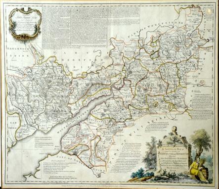
Saxton (Christopher) and Lea (Philip) Glocester-shire, engraved map of Gloucestershire with hand-colouring, `Corrected and Amended with many Additions by P.Lea`, 1690 or later, title cartouche, scale of miles with calipers, inset town plans of Bristol and Gloucester, Royal Arms and armorials, 15½ x 19¾in. (39.5 x 50cm.).


-
109182 item(s)/page