We found 109198 price guide item(s) matching your search
There are 109198 lots that match your search criteria. Subscribe now to get instant access to the full price guide service.
Click here to subscribe- List
- Grid
-
109198 item(s)/page


Lot 291
WRAXALL N. W. A Tour Through the Western, Southern & Interior Provinces of France in the Year 1775 & 1776. Half title. 12mo. Orig. brds., some wear & splitting to back strip. 3rd ed., "Corrected & Augmented", 1807; also (John Barrow), A Family Tour Through South Holland, Up the Rhine & Across the Netherlands to Ostend, eng. frontis, fldg. eng. map & 9 eng. plates, as called for (some plates with marginal damp stng.), 24mo, old calf, bookplate of Earl de Grey, Wrest Park, 1831. (2).


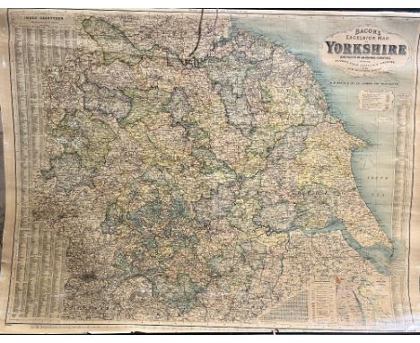
Lot 682
"Bacon's Excelsior map of Yorkshire and parts of the joining Counties showing Railways, Roads, Elevations and Distances also Local Government Divisions, revised according to the latest Ordnance Survey', a hanging wall map with index to boroughs, urban and rural districts and index - Gazetteer, printed by John Bartholomew & Co Edinburgh, H88cm W117cm


Lot 43
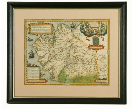
Joan Blaeu Britannia, hand coloured engraved map of the British Isles, circa 1645, the vertical margins decorated with fourteen cartouches of Saxon figures and events, with good margins, 46 x 56cmeven toning; a few spots noted to margins, surface appears not stuck down as has slight undulation. Modern black frame with gilt slip

Lot 203
ORMEROD (George) The History of the County Palatine and City of Chester, 1st edition in 3 vols. 1819, folio, portrait frontis, hand-coloured engraved double-page map, 46 engraved plates and plans of which 3 hand-coloured, illustrations, some occasional foxing and staining with off-setting, in good 20th century half morocco with gilt spines by Bell Golding


Lot 66
STANFORD (Edward; publisher) Stanford's London Atlas of Universal Geography, 1887, large folio, additional half-title, dedication, preface, contents and index, 90 (complete as list) double and single-page colour lithographic maps, including a good map of Cyprus, tabbed edges, half morocco, text block loose in places
Lot 158
DUKE (E) The Druidical Temples of the County of Wilts, 1846, 8vo, folding map and 2 plates, author's presentation inscription, original cloth; BINGLEY (Rev. W) A Tour round North Wales, in 2 vols. 1800, 8vo, 4 plates, 16pp. engraved music, some foxing and browning, modern half calf; CARTER (Matthew) Honor Redivivus, or, An Analysis of Honor and Armory, London 1673, 12mo, engraved title, lacking frontis, with 9 engraved costume plates and numerous shields to text, a little age toned, calf; BOSWELL (James) London Journal 1762-63, Heinemann 1951, no.659/1050 copies, vellum backed cloth, slip case (5)

Lot 383
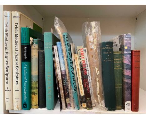
Ireland - guides, travel and topography. HAYWARD (R) In the Kingdom of Kerry, 1946, inscribed by the author; SYNGE (John) In Wicklow West Kerry and Connemara, 1st edition, Dublin 1911, 8vo, illustrated by J B Yeats, cloth gilt; RYLAND (Rev. R H) The History ... of Waterford, 1824, John Murray, 8vo, folding map, plans and plates, ex. library with front board detached; PETTIT (Dr S F) This City of Cork 1700-1900, 1st edition 1977, inscribed by the author, dust jacket; CASSERLEY (H C) Outline of Irish Railway History, 1st edition 1974, dust jacket (faded spine); with other various guide books, railway and travel, etc


Lot 69
TEESDALE (Henry & Co) Map of the County of Yorkshire, constructed from a survey commenced in the year 1817 and corrected in the years 1827 & 1828. London 1828, hand coloured engraved sectional map by J. Bingley, in 3 folding sheets, silk edged, overall size circa 184 x 222cm, some slight offsetting, in slightly rubbed tree calf book-form casei


Lot 63
Hubert Jaillot after Sanson Estats de l'Empire du Grand Seigneur des Turcs en Europe, en Asie et en Afrique, hand coloured engraved map, circa 1690, some damage and repairs to margins, 61 x 92cm (visible); with 5 other maps - Italy and Sicily by P. Schenk, 1703; Carnarvonshire by Speed, 1610 (Sudbury & Humble); Glamorganshire by Speed, 1676 (Bassett & Chiswell); Cambridgeshire by Cary, 1805; all with some age fading, general discolouration and occasional damage (6)

Lot 56
Gerard Mercator Eboracum, Lincolnia, Derbia, Staffordia, Notinghamia, Lecestria, Rutlandia et Norfolcia, hand coloured map of Eastern England counties, circa 1600, 40 x 50.5cm (visible);Nouvelle Carte du Gouvernement Civil d'Angleterre et de celuy de la Ville de Londres, circa 1720, hand coloured map of England with London below and panels of French explanatory text, 39 x 49.5cm (visible) Marcator map with good margins, even tone. Acquired from Jonathan Potter Antique Maps, London.French map uniformly toned with paler centre fold strip. Good margins.

Lot 68
John Speed Cambridgeshire described, hand coloured engraved map, published by Sudbury & Humble, circa 1630, English text verso, 43 x 53cm (visible);with another map of Cambridgeshire by Joan Blaeu, 1645, hand coloured, with Latin text verso, 43.5 x 54cm (visible)Both maps in modern double glazed frames. Speed map has general discolouration to the paper and gapping/tear to lower section of centre fold.

![BAIN (James; editor) The Authentic Map Directory of London and Suburbs, 4th edition, Geographia Limited, no date [circa 1936]](https://cdn.globalauctionplatform.com/9efa7f85-8db8-4737-800c-b12900e1d7ae/c18ae15a-0dbd-451d-8d49-b13b00f436f8/468x382.jpg)

Lot 220
ROBERTSON (William) Works, in 8 vols, London 1840, 8vo, portrait frontis (foxed), 6 folding maps and 1 folding plate with some dampstaining and foxing, half calf by White, Pall MallVol 6 – “Gulf of Mexico” has 3cm tear at margin light spotting “South America” small 1cm tear at margin, damp staining and discolouration fairly extensive Vol 7 – “Mexico or New Spain Shewing the route of Cortez” tear 4cms at margin, and two further small ones along outer top edge (beyond printed map) approx. 0.75cms each. Some spotting and staining.“Map of the Kingdom of New Granada”, spotting, fold on top left corner, tear at left hand edge 3cm Vol 8 – “Map of Asia according to Ptolomy” – extensive damp staining “Map of the South West part of Asia” extensive damp staining, tear at left edge 1cm.


Lot 233
WRIGHT (T) The Picturesque Beauties of Great Britain - Kent and Essex, 1834, 4to, folding map of Essex, engraved plates (2 images per plate), some typical staining, half calf, rubbed; NEWCOURT (Richard) Repertorium Ecclesiasticum Parochiale Londinense: An Ecclesiastical Parochial History of the Diocese of London, vol. 2 only, Benj. Motte, 1710, folio, some browning, panel calf, worn spine (2)

Lot 224
HEBER (Reginald, Bishop of Calcutta) Narrative of a Journey Through the Upper Provinces of India from Calcutta to Bombay 1824-1825, in 2 vols. London: John Murray 1828, 4to, uncut, map hand coloured in outline, frontispieces, plates and engravings in the text, vol. I plate I 'Pagoda' called for and not present as usual and replaced with 'Ghat Between Calcutta and Barrackpoor' as a frontispiece, foxing and staining, contemporary cloth, faded and rebacked preserving spine strips; HALE (T) A Compleat Body of Husbandry, London: for T. Osborne et al. 1756, folio, engraved frontispiece and 12 plates, occasional faint spotting, later half morocco, rather rubbed and chipped

Lot 303
History and others. MORANT (P) The History and Antiquities of Essex, 2 vols., Meggy and Chalk, 1816/17, 4to, folding map, half calf, rebacked, rubbed; BERNERS (Dame Juliana) The Book of Saint Albans, 1881, 4to, uncut, boards; Rivers of Great Britain, Rivers of the East Coast, 1892, 4to, illustrated, green cloth gilt; YERBURGH (H B) Leaves from a Hunting Diary in Essex, 2 vols., 1900, illustrated, recent red morocco backed cloth; KNIGHT (C) Old England, 2 vols., folio, cloth; Royal Commission on Historical Monuments, Essex, 2 vols; The Forest of Essex, 1887, binding damaged (11)


Lot 159
LELAND (Thomas) The History of the Life and Reign of Philip, King of Macedon, 2 vols., 1st edition, London: Thomas Harrison for W Johnston, 1758, 4to, half-titles, engraved frontispieces, plate of coins and large folding map of ancient Greece, list of subscribers, contemporary sprinkled calf; DRINKWATER (John) The History of the late Siege of Gibraltar, 1786, 4to, 2nd edition, lacking a plate, some creasing and damage to folding maps and plates, calf gilt


Lot 184
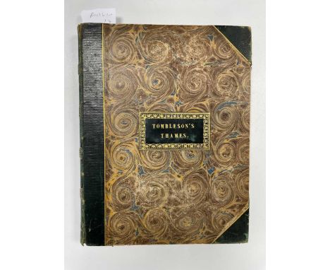
TOMBLESON (William & William Gray FEARNSIDE) Tombleson's Thames, London & Germany: Tombleson & Company, circa 1840, 4to, 80 engraved views, including title, folding engraved panoramic map of the Thames and Medway, some light spotting and offsetting, half calf over marbled boards, a little rubbed

Lot 260
MARKHAM (Col. F) Shooting in the Himalayas, 1854, R. Bentley, 8vo, additional wood-engraved pictorial title, 8 tinted lithographed plates, folding map, some foxing and spotting, one margin reinforced, marginal tear to first plate, library stamps to title, original pictorial blind-stamped green cloth, gilt, a little rubbed, rebacked preserving original gilt spine (faded), corners worn

Lot 148
CHAMBERLAIN (Henry) A New and Compleat History and Survey of the Cities of London and Westminster. London: for J. Cooke. no date [1770], folio, engraved frontispiece, plates, as required, folding map and folding plan of London, slight spotting and toning, occasional stains, ink graffiti to one blank page, reverse calf
Lot 72
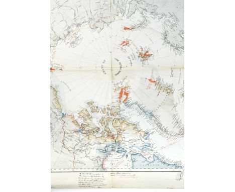
RAE, John (1813-1893, Explorer and Surgeon) Historical North Polar Map - North West Passage. Chart of the North Polar Sea, lithographic map by Malby & Sons, with some hand colour, annotated in black and red ink by John Rae, Scottish explorer and surgeon. His marginal note states 'Here the hydrographer of the Admiralty took 10 or 15 miles from my discoveries so as to make Collinson's appear the farthest. I was at this place a year (in 1851) before Collinson. [signed] J Rae'. Rae's discoveries are marked in black ink; his 'track on coast / previously explored' is marked in red.Albert Pell of Hazlebeech, Northants, and by descent.John Rae was second in command of Sir John Richardson's party sent to search for the lost Sir John Franklin expedition in 1848. The Rae Strait at King William Land is named after him. It was the final piece of the jigsaw in discovering a North-West Passage. Rae completed four Arctic exploration voyages. He mapped much of the Arctic coastlines on foot or by boat. Lady Franklin did not accept the circumstances of the aftermath of her husband's doomed voyage, and campaigned against Rae, damaging his public reputation for years to come.Fold creases and some damp staining. Originally inserted within the atlas, lot 62.size is 86 x 69cmAccording to papers still in family hands, in 1879 Albert Pell MP was given a Royal Commission to travel and observe agricultural practices in the United States of America and Canada. Accompanied by Mr Clare S Read, they left for New York in August 1879 and travelled extensively until mid December, formulating a report on modern farming practices, and also the export and transportation of produce. A letter in September 1879 finds the men in Portage La Prairie residing at the Hudson Bay Company's Office:"We have met Mr Mactavish inside Fort Garry one of the officers of the company and he was kind enough to press us to go in the the interior for 72 miles, offering us his assistance and the use of the Company's steam and stores... in the evening I walked with Mr Hespeler the Emigration Agent to visit a friend Mr MacMicken (sic) on the other side of the Assinniboine River and I had the pleasure of rowing across it.... Mr MacMicken lives in a nice wooden house in the opposite bank. He is a fine old gentleman.... The indian or Red River cart is of the rudest kind there is not an ounce of iron about it, no tire even to the wheels which are very lofty. The axle is attached to the body with strips of buffalo hide.....and the whole affair is called a "rig".... We drove the first team 25miles right off, the next 22, and the last 16 miles with changed at the Hudson Bay's ports or stores. The drive was a most interesting one - the track was alive with people, carts, oxen, hores, mares and foals, women, children and a few dogs.... The caravans ..... are going to Winnipeg for the job of taking freight for the Company as far west as the Rocky Mountains - they are paid once cent per 100lbs per miles and an ox draws just 1000 thus earning 5d per mile. Those we overtook were loaded with barrels, bags of flour, stoves, digging forks, cotton, shoes..."Whilst these family records do not tell of a meeting between Pell and Rae, they would seem to be working in similar fields at this point. According to the Dictionary of Canadian Biography in this same year "From 1879 Rae was involved in the controversy over the relative merits of the route through Hudson Bay and that by the Great Lakes and the St Lawrence River for exporting grain from the prairies. On the basis of his experience Rae strongly supported the Great Lakes route".

Lot 60
Joan Blaeu and Jan Jansson Huntingdonensis Comitatus, hand coloured engraved map of Huntingdonshire, circa 1645, 41 x 51cm (visible) Leicestrensis Comitatus cum Rutlandiae vulgo Leicester & Rutlandshire, hand coloured engraved map, circa 1650, 45 x 56.5cm (visible)Both uniformly toned. Leics map with a few spots and closed small tears. Both in modern gilt frames

Lot 71
BRYANT (Arthur) Map of the County of Lincoln, from Actual Survey, made in the years 1825-26 & 27. London 1828, hand-coloured engraved map on 2 folded sheets, each circa 165 x 110cm including margins, with an engraved vignette of Lincoln Cathedral at the foot, silk edged, general slight age toning, in rubbed calf book-form case


Lot 64
Joan Blaeu Wallia, hand coloured engraved map of Wales, circa 1645, 42 x 53cm (visible);Comitatus Caernarvoniensis et Mona Insula, hand coloured engraved map of Carnarvonshire with the Isle of Anglesey, circa 1645, 45 x 57cm (visible), French text verso.Wales map with good margins, nicely coloured impression without particular problems. Faint stain at top margin near centre fold. Modern black frame.Carnarvonshire is uniformly toned, original paper creases to left margin. Good margins, but some signs of reverse text showing through. Double grlazed modern black frame
Lot 199
CLUTTERBUCK (Robert) The History and Antiquities of the County of Hertford, 3 vols. 1815-27, folio, map and plates as required, some index leaves with repaired margins, very slight toning and dust staining in a few places, with a separate vol. of 'proof illustrations', variously mounted, light dust staining, all in later brown half morocco (4)

Lot 441
ALDIN (Cecil) collection of illustrated works. An Artist's Models, 1930, dust jacket; Just Among Friends, 1935, dust jacket; Scarlet to M.F.H., 1933, worn dust jacket; A Dozen Dogs or So, 1928; Hunting Scenes, 1936, torn dust jacket; The Romance of the Road, 1933, with map at end; Smugglers' Gallows, 1936, dust jacket foxed and chipped; The Pickwick Papers, 2 vols. 1910; etc. (22)
-
109198 item(s)/page