

Surtees (Robert). The History and Antiquities of the County Palatine of Durham, 4 volumes, 1st edition, for Nichols, Son, and Bentley, and G. Andrews, 1816-40, 82 engraved plates including one not listed in contents ('Raby Castle' after J. M. W. Turner, bound as frontispiece to volume 4), plates variably spotted, contemporary tree calf, rebacked with original spines laid down, sides scuffed and rubbed, volume 1 top spine compartment replaced in facsimile, folio (42.5 x 26.5 cm), together with: Bartlett (William Henry, & William Brockedon, illustrators), The Waldenses, or Protestant Valleys of Piedmont, Dauphiny, and the Ban de la Roche, by William Beattie, 1st edition, George Virtue, 1838, engraved frontispiece, additional vignette title, folding map, 70 plates, tissue guards, marginal damp-staining to first few plates, contemporary green morocco gilt by Davinson of Alnwick, rubbed, spine sunned, stripping to covers, 4to, Billings (Robert William), Architectural Illustrations and Description of the Cathedral Church at Durham, 1st edition, for T. and W. Boone and the author, 1843, 75 engraved plates, spotting, contemporary half calf, patterned cloth sides, superficial wear to corners, 4to, and approximately 15 others, mainly 19th-century topographical works on the Midlands and the north of England, contemporary leather bindings, some minor wear, 4to and 8vo Upcott pp. 609*-11* (Surtees). (approx. 20)
We found 109182 price guide item(s) matching your search
There are 109182 lots that match your search criteria. Subscribe now to get instant access to the full price guide service.
Click here to subscribe- List
- Grid
-
109182 item(s)/page
Lancashire. Cary (John), A Topographical Plan of Manchester and Salford with the adjacent parts shewing also the different alloments of land proposed to be built on..., published C. Laurent, 1793, large uncoloured engraved map on two conjoined sheets, inset maps of the road from London to Manchester, the environs of Manchester and a plan of Manchester and Salford taken about 1650, old folds, some repaired and strengthened on verso, slight staining, 1065 x 900 mm, together with Stockdale (John, publisher), A new map of the country round Manchester, 1794, engraved map with contemporay outline colouring, sectionalised and laid on linen, slight fraying where folds cross, 795 x 840 mm, with another copy similar but not laid on linen, plus, Greenwood (C. & G.), Map of the County Palatine of Lancaster from an actual survey..., 1830, engraved map with contemporary hand colouring, calligraphic title, compass rose, table of explanation and an uncoloured vignette of Lancaster Castle and church, slight staining to margins, occasional marginal closed tears, 640 x 685 mm, and The Graphic (publisher), A Bird's-Eye view of Manchester, 1889, large uncoloured panorama, old folds, occasional closed tears, crudely repaired on verso, occasional marginal closed tears, 560 x 1200 mm, together with Canal Map, Plan of the Rochdale Canal and Intended Railway from Sowerby Bridge to Manchester, circa 1830, lithographic plan with sparse outline colouring on three conjoined sheets, some marginal closed tears with occasional loss, some crudely repaired on verso, 400 x 1635 mm, with The Illustrated London News, (publisher), Liverpool, 1865, two uncoloured panoramas of Liverpool and the River Mersey, with key plate and descriptive text, old folds, each approximately 400 x 1055 mm (9)
Meredith (Louisa A.). Our Island Home, A Tasmanian Sketch Book, 1879, 13 monotone plates including half title, some light marks and spotting, original gilt decorated brown cloth, boards and spine lightly rubbed to head and foot, large 4to, together with Collinson (John), The History and Antiquities of the County of Somerset..., 4 volumes with Index, 1791-1898, numerous black and white plates including folding map frontispiece to volume 1, some spotting and light marks, uniform contemporary gilt decorated tree calf, some boards detached and rubbed, large 4to, and Michelet (Jules), The Insect, 1883, numerous black and white illustrations, some slight spotting, original gilt decorated brown cloth, spine lightly rubbed to head and foot, 8vo, plus other 19th and 20th century history, topography, and natural history reference, some leather bindings, mostly original cloth, G/VG, 8vo/4t (6 shelves)
![Strada (Famiano). De Bello Belgico decas prima [- Secunda]. Ab excessu Caroli V. Imp. usque ad initia praefectura Alexandri F](https://cdn.globalauctionplatform.com/bf4911eb-d0e9-428e-a339-a9d900e12ae8/5c04b49b-86a0-498e-8d31-a9d9011bcf75/468x382.jpg)
Strada (Famiano). De Bello Belgico decas prima [- Secunda]. Ab excessu Caroli V. Imp. usque ad initia praefectura Alexandri Farnesii Parmae, ac Placentiae ducis III. Additis hominum illustrium ad historiam praecipuŠ spectantium imaginibus ad vivum expressus..., 2 volumes, Leiden, Jacobi Marci, & Rome: Haeredes Francisci Corbelletti, 1645 & 1648, additional engraved title to first volume, folding engraved map of the Low Countries in the form of a lion (Leo Belgicus), and 23 portrait plates, early signature to letterpress titles, contemporary vellum with yapp fore-edges, manuscript titles to spines, 12mo, together with Asterius (of Amasea), S. Asterii episcopi Amaseae homiliae GraecŠ & LatinŠ nunc prim—m editae Philippo Rubenio interprete. Eiusdem RubenI Carmina, Orationes, & Epistolae selectiores: itemque Amicorum in vita functum Pietas, Antwerp: ex Officina Plantiniana, apud Viduam & Filios Joannis Moreti, 1615, engraved printer's device to title, engraved portrait plate, double-column text in Greek & Latin, bookplate of William Stirling Maxwell, contemporary vellum with yapp fore-edges, blind embossed armorial and monogram to boards, lacking ties, 4to, with Rubenius (Albertus), De re vestiaria veterum, praecipue de lato clavo libri duo, et alia eiusdem opuscula posthuma, quorum seriem adversa pagina exhibet, Antwerp: ex officina Plantiniana Balthasaris Moreti, 1665, three folding engraved plates, few illustrations and decorative initials, contemporary vellum, 4to, plus other 17th & 18th century continental antiquarian, all vellum bound, including few odd volumes (7)

*Somerset. Bowen (Emanuel), An improved map of the county of Somerset divided into its hundreds laid down and collected from the best material..., Carington Bowles & Robert Sayer, circa 1765, engraved map with contemporary outline colouring, large black & white cartouche, inset town plan of Bath, 535 x 710 mm, mounted, framed and glazed (1)

North America. Sayer (Robert, & J. Bennett, publishers), North America from the French of Mr. D'Anville improved with the English Surveys made since the peace, June 10th 1775, engraved map with contemporary outline colouring, sectionalised and laid on linen, slight staining, edged in green silk (partially detached), 465 x 515 mm (1)

Watkins-Pitchford (D.J., "BB"). A Carp Water (Wood pool) and how to fish it, 1st edition, published Putnam, 1958, additional half title, frontispiece, map and illustrated chapter headings throughout, later endpapers, modern green half morocco gilt, slim 8vo, together with Confessions of a Carp Fisher, 1st edition, published Eyre & Spottiswoode, [1950], additional half title, frontispiece and illustrated chapter headings throughout, small professional repair to upper corner of half title, later endpapers, modern green half morocco gilt, 12mo, with The Fisherman's Bedside Book, 1st edition, published Eyre & Spottiswoode, 1945, additional half title, numerous illustrations throughout, later endpapers, modern green morocco gilt, 12mo (3)

Wyld (James). A General Atlas, Containing Maps Illustrating some Important Periods in Ancient History and distinct Maps of the Several Empires, Kingdoms and States in the World, published Edinburgh for John Thomson & Co. for Baldwin, Craddock & Joy, London & John Cumming, Dublin, circa 1820, frontispiece of a comparison plate of the heights of the principal mountains of the world, decorative calligraphic title, 28 pages of 'A memoir of the Histry of Geography' containing 5 engraved views of principal mountain ranges and a pictorial circular map of the western hemisphere, one further comparison plate of the principal rivers of the world and 44 (complete as list) engraved maps (including 2 double page), all with contemporary outline colouring, very some dust soiling throughout, index bound at rear, near contemporary ink and pencil annotations to rear pastedown, hinges and joints cracked and split, upper board near detached, contemporary half calf with printed label to upper cover, heavily worn and rubbed, 4to (1)
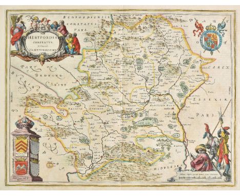
Hertfordshire. Saxton (Christopher), Hartforddiae comitatus nova vera ac particularis descriptio, circa 1579, engraved map by Nicolas Reynolds, with contemporary hand colouring, large ornate cartouche and mileage scale and with the coat of arms of Thomas Seckford in the lower right corner, the map shows signs of having been 'washed', two small repaired worm holes on either side of the central fold, lower margin trimmed with slight loss but skilfully repaired and extended in facsimile, 395 x 500 mm The first engraved map of the county of Hertfordshire with the 'bunch of grapes' watermark. (1)
![Bible [English]. [The Holy Bible, conteyning the Old Testament, and the New: newly translated out of the originall tongues...](https://cdn.globalauctionplatform.com/bf4911eb-d0e9-428e-a339-a9d900e12ae8/b9ef7243-866d-4d85-a918-a9d9011baf8b/468x382.jpg)
Bible [English]. [The Holy Bible, conteyning the Old Testament, and the New: newly translated out of the originall tongues..., Imprinted at London: By Robert Barker, 1612], lacking general title (A1), Apocrypha present, New Testament title within woodcut border present, double-column roman text, 18th century inscriptions to verso of New Testament title and final leaf of Revelation (relating to a James & Robert Wilson), bound with at front a defective Book of Common Prayer and Genealogies by John Speed, with remnants of Genealogies title, includes double-page woodcut map of Canaan, bound with at rear an incomplete Booke of Psalmes, London: Imprinted for the Companie of Stationers, 1612, occasional fraying, browning, spotting & few marks etc. throughout volume, few other early inscriptions, front free endpapers replaced, lacking rear endpapers, contemporary sheep to upper board, lacking rear board, old calf reback, rubbed and worn, 4to Herbert 313; Darlow & Moule 242; STC 2219. The first quarto edition of the King James version; printed in roman type. With Ruth iii:15 'hee'. The New Testament title omits the words 'Appointed...'. (1)
Marsden (William). The History of the Sumatra, containing an account of Government, Laws, Customs and Manners of the Native Inhabitants..., 1st edition, printed for the author, 1783, folding engraved map, some spotting throughout, contemporary calf, some wear, upper cover detached and lower joints cracked, 4to (1)
![World. Cloppenburgh (Jan & Jansson heirs of), Typus Orbis Terrarum, [1630, but 1673 edition], uncoloured engraved map, s](https://cdn.globalauctionplatform.com/bf4911eb-d0e9-428e-a339-a9d900e12ae8/da4f7ea0-3b50-40a8-8c1f-a9d9011b7fba/468x382.jpg)

Douglas (Robert). The Peerage of Scotland..., 1764, The Barnage of Scotland..., 1798, both Edinburgh, some light spotting and offsetting, contemporary full calf, boards partially detached and rubbed with minor loss, folio, together with Thomson (Thomas), An Historical Enquiry regarding the imposition of taxes upon land in Scotland, 1816, 5 facsimile documents, author's copy with marginal annotations, guttering reinforced with brown cloth tape, some light spotting and offsetting, contemporary half calf, boards and spine lightly rubbed, 4to, and Stirling (William Macgregor), History of Stirlingshire, 2 volumes, 2nd edition, Stirling, 1817, colour folding map frontispiece to volume 1, black and white map in volume 2, some spotting and offsetting, uniform contemporary gilt decorated half calf, front boards partially detached, slightly rubbed, 8vo, plus other 18th and 19th century Scottish topography and history reference, including The Dundee Year Book, 15 volumes, 1884-98, many leather bindings, some original cloth, condition is generally good/very good, 8vo/folio (78 volumes) (3 shelves)

New Zealand. Arrowsmith (John), Map of the colony of New Zealand from official documents, 1844, engraved map with contemporary outline colouring on two sheets, inset map of the world on a Mercator projection, old 'stitching holes' to left hand margin, old folds with some fraying, 610 x 480 mm, with three printed sheets on a census of native population and their localities A scarce map of New Zealand. First issued in the 1830s, this state shows the progress in the exploration and development of New Zealand, but still pre-dates the addition of New Zealand's counties.The three islands of New Zealand are labelled as New Ulster, New Munster and New Leinster, a nomenclature soon abandoned, that coincided with the period of Irish immigration following the Potato Famine. (1)

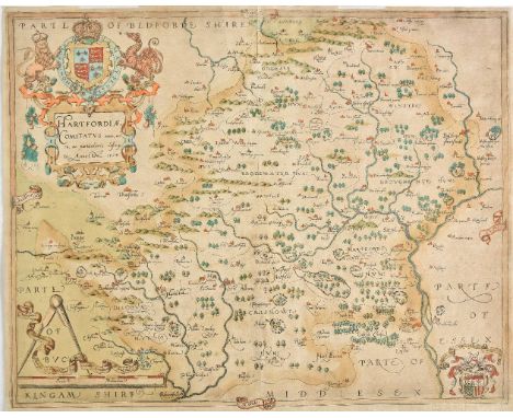
Hertfordshire. Speed (John), Hartford Shire described, the sittuations of Hartford and the most ancient towne St. Albons with such memorable actions as have happened, 1st edition, John Sudbury & George Humble, [1611], hand coloured engraved map inset town plans of Hertford and Verolanium (St. Albans), occasional repaired closed tears, central fold strengthened on verso, 380 x 510 mm, English text on verso (1)

*Denbighshire. Speed (John), Denbighshire, John Sudbury & George Humble, 1616, hand coloured engraved map, inset town plan of Denbigh, framed and double glazed, 380 x 510 mm, Latin text on verso, together with Merionethshire described, Thomas Bassett & Richard Chiswell, [1676], hand coloured engraved map, inset town plan of Harlech, slight creasing, 380 x 505 mm, mounted, framed and double glazed, English text on verso, with Saxton (Christopher & Hole G.), Monumethensis comitatus quem olim incoluerunt silures, [1610], hand coloured engraved map, some water staining, 280 x 345 mm, mounted, framed and glazed, plus Morden (Robert), Warwickshire [1695 or later], hand coloured engraved map, 355 x 420 mm, mounted, framed and glazed, with two other maps of Warwickshire by Edward Weller, each approximately 465 x 305 mm, both framed and glazed (6)
Coxe (William). An Historical Tour in Monmouthshire; Illustrated with Views by Sir R.C. Hoare..., 2 parts in one, 1801, half-titles present, folding engraved map (closed tears to folds and minor marks), 91 engraved plans and views (including 2 folding), advertisement leaf at rear of volume, spotting & damp mottling, offsetting and toning throughout, top edge gilt, remainder untrimmed, near contemporary half morocco, gilt decorated spine, worn at head & foot of spine and to extremities, 4to, together with Roscoe (Thomas), Wanderings and Excursions in North Wales, 1844, half-title, additional engraved title, folding engraved map hand-coloured in outline and numerous plates, some spotting mostly to margins, edges untrimmed, modern quarter morocco gilt, marbled boards, 8vo, with Turner (Thomas), Narrative of a Journey, associated with a fly from Gloucester to Aberystwith, and from Aberystwith through North Wales. July 31st to September 8th 1837, London: Printed for private distribution only, 1840, half-title, engraved portrait frontispiece, 11 engraved plates, light scattered spotting, front blank inscribed to 'the Venerable Archdeacon Probyn with the Author's Compliments', upper hinge split, contemporary green morocco backed cloth, gilt decorated spine, rubbed, 8vo, with Warner (Richard), A Walk through Wales, in August 1797, 4th edition, Bath: Printed by R. Cruttwell, 1801, few plans to text, extra-illustrated with tinted aquatint frontispiece, 2 hand-coloured aquatint plates and one engraved plate, some offsetting and spotting, library stamp to verso of title, final leaf and front endpaper, cloth hinge repairs, modern half sheep over contemporary marbled boards, 8vo, and A Second Walk through Wales, by the Revd. Richard Warner, of Bath. In August and September 1798, 2nd edition, Bath: Printed by R. Cruttwell, 1800, tinted aquatint frontispiece, plans to text, toning, spotting and few marks, near contemporary half calf, joints rubbed, 8vo, plus other Welsh topography related, mostly 19th century publications (11)
*Maps. Ogilby (John), The continuation of ye extended road from Barnstable to Truro..., [1675 or later], hand coloured engraved strip road map, 355 x 455 mm, mounted, framed and glazed, together with Janvier (Jean), Les Isles Britianniques comprenant les royaumes D'Angleterre, D'Ecosee et D'Irlande divis‚s on grandes provinces..., Paris, circa 1760, hand coloured engraved map, inset map of the Shetland and Orkney islands, 315 x 455 mm, mounted, framed and glazed, with Tavernier (Melchior), Patriarchatus Hierosolymitani geographica decriptio, Paris, 1640, hand coloured engraved map, slight creasing, 355 x 505 mm, mounted, framed and glazed, plus Van den Keere (Pieter),Midle-sex, circa 1627, hand coloured engraved miniature map, 80 x 115 mm, mounted, framed and glazed, and Badeslade (T. & Toms W. R.), A map of Hertfordshire, 1742, hand coloured engraved map, 150 x 150 mm, mounted, framed and glazed (5)
Quin (Edward). An Historical Atlas; in a Series of Maps as the World as known at Different Periods, 1st edition, for R. B. Seeley and W. Burnside, 1830, engraved title page, all text-leaves as called for, 21 hand-coloured engraved maps, 6 folding, the first 18 with black aquatint, occasional pale tide-mark in lower margins (text and images never affected), title page and initial text leaves slightly nicked and marked, the aquatinting faintly mottled and offset, first map with paper disruption in gutter not affecting image, folding maps with linen tape-supports along versos of folds (possibly as issued), endpapers renewed, original marbled boards, rebacked and recornered, original paper label to front board, rubbed, folio (42 x 32.5 cm) First edition of this sought-after atlas which illustrates the growing extent of the known world from 'the deluge' (2348 BC) to 1828 by means of the gradual receding of a dramatic black aquatint cloud. There was a quarto edition in 1836 which is far more usually encountered. (1)

Warwickshire. Speed (John), The Counti of Warwick The shire towne and citie of Coventre described, John Sudbury & George Humble, circa 1627, hand coloured engraved map, inset town plans of Warwick and Coventry, 380 x 505 mm, English text on verso, double mounted and displayed between two perspex boards (1)
Nash (Treadway Russell). Collections for the History of Worcestershire, 2 volumes, 2nd edition, 1799, engraved portrait frontispiece, folding engraved map to volume 1 (strengthened to folds at verso and reguarded), engraved vignette title to each volume, 73 engraved plates & plans (including two engraved dedication leaves, lacking three plates & one with repaired closed tear), numerous engraved illustrations to text and 18 folding pedigrees, 13 engraved leaves of Domesday Book, includes Supplement at rear of volume 2, one or two paper repairs, ink stamps to lowere outer corners of titles and manuscript number to verso, contemporary half calf gilt, rebacked preserving original contrasting morocco labels, corners repaired, folio Upcott p.1330. (2)
Kennedy (William). Texas: the Rise, Progress, and Prospects of the Republic of Texas, 2 volumes, 1st edition, London: R. Hastings, 1841, 2 engraved charts, 1 engraved folding map of Texas (of 2: lacking the Arrowsmith map; a duplicate of the second map bound in its place to face the title page, tape-repaired), contents toned, title page slightly soiled, advertisement leaf stained, closed marginal tear in volume 2 leaf R6, folding map backed on linen, 20th-century half sheep, 8vo (21.4 x 13 cm) Howes K92 aa; Jenkins 117; Sabin 37440. Rare first edition of Kennedy's highly influential account, of which Jenkins speculates that Arrowsmith's map was 'included in only a portion of the copies ... as only a small percentage of surviving copies contain it'. For a copy of Arrowsmith's map see lot 100. (2)
*Gloucestershire. Speed (John), Glocestershire contrived into thirty thre severall hundreds & those againe into foure principall devisions. The citie of Glocester & Bristowe discribed with the armes of such noble men as have bene dignified with ye titlles of Earles & Dukes thereof, John Sudbury & George Humble, circa 1627, hand coloured engraved map, inset town plans of Gloucester and Bristol, slight browning to lower right corner, central fold strengthened on verso, 385 x 515 mm, English text on verso, framed and double glazed (1)
![[Burke, Edmund; attributed]. An Impartial History of the War in America, between Great Britain and Her Colonies, from its Com](https://cdn.globalauctionplatform.com/bf4911eb-d0e9-428e-a339-a9d900e12ae8/43ffff25-ce71-4f35-8d70-a9d9011b413c/468x382.jpg)
[Burke, Edmund; attributed]. An Impartial History of the War in America, between Great Britain and Her Colonies, from its Commencement to the End of the Year 1779, 1st London edition, for R. Faulder, and J. Milliken, Carlisle, 1780, engraved folding map of North America as frontispiece, 13 engraved portrait plates of American revolutionaries, map browned and offset and with short split (3 cm) to one fold, plates offset, modern morocco, 8vo (21 x 12.5 cm) Church 1171; ESTC T45611; Howes B975 aa; Sabin 34375. The text was plagiarised from the Annual Register and first published separately at Dublin the previous year as The History of the War in America ... to the End of the Year 1778 (in two volumes, with a third printed in 1785; see Sabin 32226), but this London edition is the first to contain the portrait plates of American revolutionaries. There were also two other issues, with only Faulder's or Milliken's imprint on the title page. (1)

Ransome (Arthur). Swallows & Amazons, 1st illustrated edition, 1931, illustrations by Clifford Webb, a little light spotting, map endpapers, original cloth (spine faded, slight lean), dust jacket, small losses at spine ends, spine a little toned and rubbed at foot, reinforcements to verso, 8vo (1)

Anderson (David). Canada: or, a View of the Importance of the British Colonies; shewing their Extensive and Improveable Resources and pointing out the Great and Unprecedented Advantages which have been allowed to the Americans over our own Colonists, 1st edition, for J. M. Richardson, 1814, hand-coloured engraved folding map as frontispiece (2-cm split to one fold), contents largely unopened, edges untrimmed, original boards, rebacked retaining original spine-label, covers slightly marked, corners bumped, 8vo (22.8 x 13.4 cm), together with: Holditch (Robert), The Emigrant's Guide to the United States of America, 1st edition, for William Hone, 1818, 4 pp. publisher's advertisements lacking, ownership inscription date April 1827 and tipped-in carte-de-visite of London-born Philadelphia artist John Sartain (1808-1897) to initial blank, edges untrimmed, modern boards, 8vo (22.2 x 13.4 cm), and Kingdom (William, junior), America and the British Colonies. An Abstract of all the most Useful Information relative to the United States of America, and the British Colonies of Canada, the Cape of Good Hope, New South Wales, and Van Diemen's Island. Exhibiting at one view the Comparative Advantages and Disadvantages each Country offers for Emigrations, 2nd edition, for G. and W. B. Whittaker, 1820, title page slightly marked, occasional mild spotting, edges untrimmed, modern boards, 8vo Sabin 1391 (Anderson), 32485 (Holditch), 37865 (Kingdom); Howes H584 (Holditch); Howes K158, Ferguson 789 (Kingdom). Holditch's work is scarce, with four copies located on Copac and one copy traced at auction in the last 50 years. This second edition of Kingdom's work has the same collation as the first, which appeared earlier the same year. (3)
*Sussex. Speed (John), Speed (John), Sussex described and divided into rapes with the situation of Chichester the cheife citie thereof and the armes of such nobles as have bene dignified with the title of earles since the conquest and other accidents therein observed, John Sudbury & George Humble, circa 1627, hand coloured engraved map, inset town plan Chichester, some creasing, central fold split and strengthened on verso, some marginal closed tears, slight toning, 385 x 505 mm, English text on verso, framed and double glazed (1)


QUEEN - THE COMPLETE WORKS (QB1 14 x LP BOX SET). A wonderful example of the essential 14 x LP box set from 1985 (original numbered copy 011455). Complete with the Complete Works Booklet, Queen Tour Itinerary 1971 to 1985 and Queen Map of the World. All LPs and outer sleeves are in Ex+ or archive condition showing very little wear. The outer box is in superb Ex+ condition also showing very little wear - there is some light 'ink residue' on the inside of the lid.


Two 18th century black and white printed maps of Ancient Asia and Present Asia, both dedicated to his highness William Duke of Gloucester, inscribed M Burg, 39 x 53cm approx visible sheet size, together with three further maps comprising The Sunda Islands by H Moll, 21 x 27cm, an early map of India, 36 x 33cm and a 19th century map of the Malay Archipelago, 26 x 36cm, also together with a 19th century Moghul type painting of an equestrian male figure on a white horse, 16 x 12cm all framed


La Condamine, Charles Marie de. Relation Abregee d'un Voyage dans l'interieur de l'Amerique, Paris 1745, 8vo. cont.calf, folding engraved map: bound with Lettre a Madame xxx Sur la Emeute Populaire Excitee En La Ville de Cuenca au Per ou, n.p. 1746. Folding engraved map contemporary calf/Provenance: Ombersley Court


A hand tinted of Montgomeryshire dated 1605With view of Montgomery, dedication to Phillip Herbert Earle of Montgomery, described by Christopher Saxton, augmented and published by John Speede, 40x52cm, hand tinted map of 'Bark Shire' (sic) by Robert Morden early 18th Century, 36x42.5cm, framed and glazed (2)


-
109182 item(s)/page