We found 108737 price guide item(s) matching your search
There are 108737 lots that match your search criteria. Subscribe now to get instant access to the full price guide service.
Click here to subscribe- List
- Grid
-
108737 item(s)/page


Lot 1
Anburey (Thomas). Travels Through the Interior Parts of America. In a Series of Letters, By an Officer, vol. 1 only (of 2), 1789, folding eng. map, hand-col. in outline (with closed tear to vignette title cartouche), four folding eng. plts. (one with closed tear) and one single-page eng. plt, closed tear to leaves Ee4 & Ee5, contemp. mottled calf with red morocco labels to spine and red morocco ownership label of Lt. Col. Harnage to upper board, upper board detached, 8vo. Pages 423 & 427 refers to Major Harnage, with detailed marginal notes written by his grandson. Front free endpaper inscribed "Col. Harnage to Capt. Harnage 8th December 1824", also with a long inscription relating to Col. Harnage written by his grandson George Harnage. Sabin 1366. (1)
Lot 1
Baker (Samuel White). Ismailia, A Narrative of the Expedition to Central Africa for the Suppression of the Slave Trade, Organized by Ismail, Khedive of Egypt, 2 vols, 1874, eng. port. frontis. to each, wood eng. plts. and folding map, contemp. gilt dec. calf by Sayer & Wilson, with contrasting morocco labels, gilt armorial to both boards and gilt coronet to upper & lower panels of each spine, upper joint of with vol. 2 weak, extrems. slightly rubbed, 8vo. (2)
Lot 1
Burton (Captain Richard F.). Explorations of the Highlands of Brazil; with a Full Account of the Gold and Diamond Mines. Also, Canoeing Down 1500 Miles of the Great River Sao Francisco, from Sabara to the Sea, 2 vols, 1st ed, 1869, half-title present, wood eng. frontis. and addn. vign. title to each, but lacks folding map, uncut and mainly unopened, orig. cloth gilt, faded on spines and frayed and chipped at head and foot, 8vo. Sabin 9498. (2)
Lot 1
Heber (Reginald, Lord Bishop of Calcutta). Narrative of a Journey Through the Upper Provinces of India from Calcutta to Bombay, 4th ed, 3 vols, 1829, twenty-six only (of 27) wood eng. plts, ten double-page etchings (foxed), folding map with hand-col. outlines in pocket at front of first vol, partially unopened, orig. scarlet cloth gilt, spines faded, some rubbing to extrems, first vol. with upper joint cracked, 8vo, together with Sandes (Lieut.-Colnel E.W.C.), The Military Engineer in India, 2 vols, 1st ed, 1933, sixty-six b & w plts, incl. frontispieces, seventeen maps (incl. thirteen folding), of which nine in pockets at rear, several further maps and plans on letterpress, orig. red cloth gilt, some soiling, mostly to rear cover of first vol, spines sl. faded, large 8vo, plus The Royal Engineers in Egypt and the Sudan, 1st ed, 1937, fifty-two b & w plts, incl. frontis, thirty-five maps, some folding, orig. red cloth gilt, faintly damp-marked, spine faded, large 8vo. (6)
![Malta. Scatuta Hospitalis Hierusalem, [ed. G. B. Rondinelli], Rome, 1588, forty b&w copper eng. plts. in all, including tit](http://lot-images.atgmedia.com/SR/10729/2341262/27-15-10729_468x382.jpg)
Lot 1
Malta. Scatuta Hospitalis Hierusalem, [ed. G. B. Rondinelli], Rome, 1588, forty b&w copper eng. plts. in all, including title, portraits, and other plts, mostly depicting the new Cardinal officiating at various ceremonies, but including a map of Malta and a plan of La Valletta, many with woodcut border, some minor marks and occn. light marginal stains, old vellum, rubbed and some minor marks, folio. Adams J151-152. Mortimer 273. A rare work on the history of Malta, being a revised edition of the Statutes of the Knights of the Order of St. John of Jersualem, first published by A. Blado in Rome, in 1556. This edition was reprinted to celebrate the installation as Cardinal of Grand Master Hughes de Loubens-Verdale on the 18th December 1587. This copy complete with all plates and letter press. (1)
Lot 1
Parr (Captain Henry Hallam). A Sketch of the Kafir and Zulu Wars. Guadana to Isandhlwana, 1st ed, 1880, folding map with hand-col. outlines, with 2 short handling tears, several full-page plans on letterpress, 2pp. with short tear in fore-margin, 32-pp. pub. cat. at rear, upper hinge split but firm, rough-trimmed, orig. green cloth, dec. in black and gilt, sl. rubbed at spine ends and joints, 8vo. (1)
Lot 1
Robert de Vaugondy (Gilles). Nouvel Atlas Portatif DestineePrincipalment Pour L'instruction de la Jeunesse, d'apres la Geographie Moderne de feu l'Abbe Delacroix. Par le S. Robert de Vaugondy, Paris, 1790, eng. title, fifty-three double-page maps and one folding map (includes 4 world charts & maps of the Americas), hand-col. in outline, 9pp. of eng. text, folding map strengthened to verso with adhesive tape, light damp stain to fore-edge margin of last eight maps, occ. scattered spotting, contemp. qtr. calf, red morocco title label, slight wear to joints & extrems, 4to. (1)

Lot 1
Rome. Raccolta Delle Principali Vedute di Roma, A. Moschetti, n.d, c. 1848, eng. map of Rome with vignette views and fifty-nine eng. views, occ. scattered spotting and damp staining to upper outer corners, a.e.g, contemp. gilt & blind dec. morocco, boards detached and lacks spine, boards rubbed & scuffed, oblong folio. (1)
Lot 1
Shackleton (Sir Ernest). South. The Story of Shackleton's Last Expedition, 1914-1917, 2nd imp, December, 1919, col. frontis, b & w illusts. from photos, folding map at rear, orig. cloth, lettered and blocked in silver, rubbed and some wear to spine, 8vo, together with The Heart of the Antarctic. Being the Story of the British Antarctic Expedition, 1907-1909, by E.H. Shackleton, 2 vols, 1st ed, 1909, photogravure frontis. to each, several col. plts, num. b & w illlusts. from photos, three folding maps and a double panorama contained in rear pocket of vol. 2, all correct as list, some scattered spotting, t.e.g, remainder rough-trimmed, orig. dec. cloth, soiled and some wear, 4to. (3)
Lot 1
Thomas (Bertram). Arabia Felix: Across the Empty Quarter of Arabia. with a foreword by T.E. Lawrence, 1st ed, 1932, fifty-one b&w photographic plts, few charts on letterpress, lge. folding map at rear, with short handling tear, untrimmed, orig. orange buckram, spine and part of upper cover lightly faded, 8vo, together with Thesiger (Wilfred) Arabian Sands, 1st ed, 1959, forty-seven photographic plts, incl. frontis, mostly two-sided, folding map in pocket at rear, maps on letterpress, orig. cream boards, d.j, price-clipped, rear panel lightly spotted, 8vo. (2)
Lot 1
Trimmer (Sarah). A Geographical Companion, to Mrs. Trimmer's Scripture, Antient, and English Abridged Histories, with Prints, Calculated to Render the Study of History more Interesting to Children, and to Serve as an Easy Introduction to the Knowledge of the Earth. In three parts, new ed, revised & corrected by the author, 1816, half-title, folding hand-col. double-hemisphere eng. map frontis, nine hand-col. folding eng. maps (one torn without loss), some minor offsetting, contemp. sheep, joints slightly worn, 12mo. (1)
Lot 1
Whymper (Edward). Travels Amongst the Great Andes of the Equator, 1st ed, 1892, together withSupplementary Appendix, 1891, b & w illusts. to each, first vol. with two folding maps, one with two tears to central fold, folding linen-backed map contained in pocket to rear of first vol. (few short handling tears at folds, with sl. loss to lower margin), untrimmed, Foyles ticket on front pastedowns, orig. green cloth gilt, faded, spine of second vol. rubbed and darkened, both sl. frayed at foot, 8vo. (2)
Lot 1
Wild (John James). At Anchor, a Narrative of Experiences Afloat and Ashore during the Voyage of H.M.S. "Challenger", from 1872 to 1876, pub. 1878, Dtwelve mounted chromolithos, one double-page col. map, b & w illusts, occ. minor spotting, a.e.g, orig. gilt pict. cloth, rebacked retaining orig. spine, slightly rubbed, folio. (1)
Lot 1
Armstrong (Mostyn John). An Actual Survey of the Great Post-Roads between London and Edinburgh, printed for and sold by the author and the booksellers, 1776, eng. map frontis. and vign. title, fourty-four copper eng. plts. of road maps, some with minor outline-colouring, damp stained throughout to upper outer corner, bookplt. of Maria Forbes, contemp. brown half calf, rubbed and soiled, 8vo. (1)
Lot 1
Brannon (George). Brannon's Graphic Delineations of the Most Prominent Objects in the Isle of Wight, [1857], thirty eng. views, some damp staining to first & last leaves, orig. linen-backed printed card covers, rubbed & marked, oblong 8vo, together with Dugdale (Thomas), Curiosities of Great Britain. England & Wales Delineated, n.d, c.1840, eng. frontis. and title, thirty-eight double-page eng. county maps, (Berkshire map torn with loss), seventy-one eng. views, text incomplete (p5-612 only), occ. spotting and minor dust soiling, some marginal fraying, disbound 8vo, plus Winkles (H.)Our National Cathedrals, revised ed, vol. 2 only, 1888, numerous col. plts, b & w illusts, contemp. half calf, worn, 4to. (3)
Lot 1
Britton (John & Brayley, Edward Wedlake). Devonshire and Cornwall Illustrated, from Original Drawings by Thomas Allom, W.H. Bartlett etc, 2 parts in one, Fisher, 1832, eng. county map and addn. vign. title to each (one title cropped at fore-edge), 138 eng. views on 69 leaves, a.e.g, orig. green morocco-backed boards, rubbed, 4to. (1)
Lot 1
Cary (John). New and Correct English Atlas, 1793, eng. title, map of South Britain and forty-six single page eng. county maps, hand-col. in outline, complete as list, contemp. calf, worn, covers detached, rebacked in cloth, 4to. Chubb CCLXIII. This copy matches that held by the Cambridge University Library with a printed note, referring to the roads, on the verso of the list of contents. (1)

Lot 1
Cole (G. & Roper, J.). The British Atlas; Comprising a Complete Set of County Maps of England and Wales; with a General Map of Navigable Rivers and Canals; and Plans of Cities and Principle Towns, 1810, two general index maps and fifty-six hand-col. county maps, plus twenty-one uncol. eng. town plans, all correct as list, occ. spotting, mostly marginal to county maps, heavier spotting or browning to several town plans, contemp. half calf, worn and covers det, 4to. Chubb, p. 249. (1)
Lot 1
Gray (George Carrington). The Tourist and Traveller's Guide to the Roads of England and Wales, and part of Scotland, on an Entirely New Plan, 1st ed, 1824, addn. wood engraved vignette title, hand coloured folding map of England & Wales (small repaired closed tear), forty-nine uncol. county maps, a few folding, contemp. black half sheep with marbled boards, rubbed to extrems, square 8vo. Chubb CCCXCII. (1)
Lot 1
King (Daniel). The Vale-Royall of England. Or, The County Palatine of Chester Illustrated.to which is annexed, An Exact Chronology of all its Rulers and Governors.also, An Excellent Discourse of the Island of Man, 1st ed, 1656, addn. eng. title (with 19th century owners name to upper margin), two folding eng. maps only (of three - lacks county map), eleven eng. plts. of coats-of-arms, nine other eng. plts. incl some folding and some half-page, some light finger soiling, a.e.g, 19th century morocco gilt, rebacked preserving orig. spine, folio. Wing K488. (1)
Lot 1
Leigh (Charles). The Natural History of Lancashire, Cheshire and the Peak, in Derbyshire: with an Account of the British, Phoenician, Armenian, Gr. and Rom. Antiquities in those Parts, 3 parts in 1, 1st ed, pub. Oxford, 1700, eng. port frontis, eng. folding map hand-col. in outline (approx. 310 x 400 mm) and 24 eng. plts. incl. 2 of armorial shields, list of subscribers, occ. marginal finger soiling, contemp. panelled calf, rebacked with new endpapers, folio. Wing L975. (1)
Lot 1
Leycester (Sir Peter). Historical Antiquities, in Two Books. The First Treating in General of Great-Brettain and Ireland, the Second Containing Particular Remarks Concerning Cheshire.Whereunto is Annexed a Transcript of Doomsday-Book, so Far as it cConcerneth Cheshire, Taken Out of the Original Record, 1st ed, 1673, title printed in red and black, woodcut initials and armorials, uncol. folding engraved map of "The County Palatine of Chester" by John Speed (Roger Rea edition), errata leaf at rear, front blank endpaper detached (but extant), contemp. mottled calf, rebacked, folio. Wing L1943. (1)
Lot 1
Nayler (Sir George). A Collection of Coats of Arms, Borne by the Nobility and Gentry of the County of Glocester, 1792, eng. vign. title with some spotting and erased library marking to verso, sixty-two uncol. eng. plts. of arms, occasional spotting, later half calf using old boards, 4to, together with Kelly's Directory of Gloucestershire, 1885, folding map, numerous trade ads, recent cloth, 8vo. (2)

Lot 1
Owen (John and Bowen, Emmanuel). Britannia Depicta or Ogilby Improv'd; Being a Correct Coppy of Mr Ogilby's Actual Survey of all ye Direct & Principal Crossroads in England and Wales, 4th ed, 1736, eng. title, 8pp. map index, 273 uncol. eng. strip road maps printed back to back, contemp. sprinkled calf, rebacked with new endpapers, 4to. Chubb CLIII. (1)
Lot 1
Pennant (Thomas). A Journey from London to the Isle of Wight, 2 vols, 1801, folding hand-col. map frontis. to each vol, forty-seven uncol. eng. plts, lacking half-titles, occasional spotting, second vol. with minor insect damage to fore-edge of first few and last few leaves, contemp. half calf gilt, some wear, 4to. (2)
Lot 1
Phelps (Rev. William). The History and Antiquities of Somersetshire, vols. 1 and 2 [all pub.], 1st ed, 1836-39, fifty plts. incl. six maps, a few tinted, fifty eng. vigns. to text, all correct as list, together with Rutter (John), Delineations of the North Western Division of the County of Somerset, and of its Antediluvian Bone Caverns, 1829, large paper copy, col. map, plts. and illusts, list of subscribers, all three vols. in uniform half calf gilt with green morocco label to spines, sl. rubbed, 4to. First set originally issued in parts which ceased publication at p.272 of the second volume. Thus, despite finishing mid-flow, this work is complete as published. (3)
Lot 1
Rocque (John). A Topographical Survey of the County of Berks, in Eighteen Sheets. In Which is Expressed, his Majesty's Royal Palace of Windsor, pub. James Dixwell, 1761, title printed in red and black, full-page engraved dedication, lacking general map and sheet XV, contains seventeen engraved map sheets with contemp. outline hand colouring, mostly double-page, 19th century half calf, somewhat rubbed with fraying to extrems, folio. (1)
Lot 1
Holbrook (John Edwards). North American Herpetology; Or, a Description of the Reptiles Inhabiting the United States, vol. 1 only (of 4), Philadelphia, 1836, twenty-four fine hand-col. litho. plts. of turtles, frogs, lizards, and snakes, etc, some marginal dampstains, orig. boards, worn on spine and covers det, 4to, together with The Instructive Picture Book. Lessons from the Geographical Distribution of Animals, or the Natural History of the Quadrupeds, which Characterise the Principal Divisions of the Globe, by M.H.H.J, Edinburgh, 1860, sixty full-page hand-col. wood engs, modern green half morocco gilt, slim folio, plus Kelsall (Rev. J.E, and Munn, Philip W.), The Birds of Hampshire and the Isle of Wight, 1905, b & w illusts. from photos, folding map at rear, upper corner of half-title cut away, t.e.g, orig. cloth gilt, a little rubbed, 8vo, and Hamilton (Franciscus, and Don, David), Prodromus Florae Nepalensis, sive Enumeratio Vegetabilium, quae in Itinere per Nepalliam Proprie Dictam et Regiones Conterminas, Ann, 1802-1803, pub. London, 1825, half-title present, untrimmed, orig. boards, tall 12mo, and other natural history. (a carton)
Lot 1
Osbeck (Pehr). Dagbok ofwer en Ostindisk Resa aren 1750, 1751, 1752, facsimile ed, Stockholm, 1969, orig. boards, 8vo, ltd. ed. of 550 copies, together with Samuelsson (Gunnar), Studien Ueber die Vegetation der Hochgebirgsgegenden von Dalarne, Upsala, 1917, plts. from photos, folding map, contemp. cloth with orig. printed wrappers bound-in, rubbed, 4to, plus Sparrman (Anders), Resa till Goda Hopps-Udden Sodra Pol Kretsen, 2 vols, facsimile ed, Stockholm, 1968, plts. and maps, some folding, orig. half calf in pubs. slipcase, 8vo, ltd ed of 550 copies, and Linnaeus (Carolus), Flora Dalekarlica, Orebro, 1873, contemp. half calf, 8vo, together with 13 others, similar. (18)
Lot 1
Wahlenberg (Georg). Flora Suecica, 2 vols, 2nd ed, 1831-33, text in Swedish, folding chart, contemp. calf-backed boards, rubbed, 8vo, together with Flora Upsaliensis Enumerans Plantas Circa Upsaliam Sponte Cresentes, Upsala, 1820, folding eng. map tipped to title page, contemp. half calf, worn, 8vo. Stafleu & Cowen 16.523 & 16.521 respectively. (3)
Lot 1
Celestial chart. Grant (Charles).. Nova Uranographia. Or, an easy method of knowing the Constellations by the Configurations of the Principal Stars, between themselves by Charles Grant, Viscount de Vaux, 1803, hand-col. folding eng. map sectionalised on linen, approx. 620 x 580mm, contained in contemp. slipcase (rubbed). (1)
Lot 1
England & Wales. Cary (John, pub.), Cary's Reduction of his Large Map of England and Wales, with Part of Scotland, Feb. 20th, 1796, folding engraved map, hand coloured in outline and sectionalised onto linen, the whole approx. 760 x 630 mm, contained in orig. card slipcase with circular paper label to upper cover (rubbed and marked). (1)
Lot 1
English Counties. Walker (J. & C.), Hampshire, Middlesex, Dorset, Warwickshire, Herefordshire, Hertfordshire, Kent, Yorkshire (East Riding), Berkshire, c.1830s, together nine engraved folding maps, hand coloured in outline, some light spotting, approx. 340 x 420 mm, each contained in orig. cloth covers with paper labels to upper spine, some cracking at the joints, plus a similar folding map of Monmouth by William Darton. (10)
Lot 1
Folding maps. Back (J. & Sauter, C.), Carl Jugel's Post und Reise-Karte von Deutschland und den Nachbarstaaten, pub. Frankfurt, 1844, engraved folding map of Germany and much of Central Europe, sectionalised onto linen, hand coloured in outline with calligraphic title, inset map of Europe to lower right corner, approx. 1060 x 1240 mm, contained in orig. card slipcase with paper label to upper cover (rubbed), together with Royal Gazette Co. (pub.), Driving and Cycling Road Map of the Bermuda Islands, 4th ed, 1911, folding engraved map, a few short marginal tears, approx. 240 x 630 mm, contained within orig. printed boards, and others including a late 18th century Bowles & Carver folding map of the British Isles in poor condition, and others. (8)
Lot 1
Great Britain. Walker (J.), Map of the Inland Navigation, Canals, and Rail Roads with the Situations of the Various Mineral Productions throughout Great Britain, from actual surveys. accompanied by a Book of Reference, compiled by Joseph Priestley, Esqre, of the Aire and Calder Navigation, pub. Richard Nichols, Wakefield, January 1st 1830, hand-col. eng. map, sectionalised on linen, inset map of the North of Scotland, eng. title and dedication cartouche, compass rose, approx. 193 x 156 cms. overall, in orig. morocco slipcase, rubbed, large 8vo. (1)
Lot 1
Lancashire. Hennet (G.), A Map of the County Palatine of Lancaster Divided into Hundreds and Parishes from an Accurate Survey Made in the Years 1828 and 1829.Engraved by James Bingley, pub. Henry Teesdale, May 1st, 1830, hand coloured folding engraved map, sectionalised onto linen, calligraphic title, uncol. vignette of the New Custom House, Liverpool, the whole approx. 1630 x 1180 mm, contained in a contemp. tree-calf map box (heavily rubbed to extrems.). (1)
Lot 1
London. Cruchley (George Frederick, pub.), Cruchley's New Plan of London Shewing all the New and Intended Improvements to the Present Time, c.1851, hand coloured engraved folding map sectionalised onto linen, the whole approx. 440 x 850 mm, conatined in orig. cloth slipcase with orange paper label to upper cover (some minor wear to corners). Howgego 307 (20) showing the Great Exhibition in Hyde Park. Title on cover reads 'Cruchley's Superior Map of London.Improved to 1852'. (1)
Lot 1
London. Cruchley (pub.), From the Ordnance Survey of the Country Thirty Miles Round London, n.d, c.1840s, folding engraved map in four separate sheets, each hand coloured in outline and sectionalised onto linen, the whole approx. 1060 x 1320 mm, contained in orig. cloth slipcase with paper label (rubbed to extrems.). (1)
Lot 1
London. Philip (George, pub.), Philips' Tape Indicator Map of London, c.1900, colour printed folding map laid onto linen with attached tape measure in excellent condition, one or two clean fold splits, the whole approx. 620 x 900 mm, contained in orig. cloth boards with attached index booklet, together with another copy lacking the tape measure. (2)
Lot 1
London. Davies (B.R, pub.), Davies's Map of the Environs of London, 1855, folding engraved map, hand coloured in outline and sectionalised onto linen, approx. 760 x 1080 mm, contained in contemp. cloth slipcase, together with Ordnance Survey (pub.), London and its Environs, June 1861, engraved map, hand coloured in outline and sectionalised onto linen, approx. 730 x 1190 mm, contained in cloth slipcase with paper label to upper cover, and other folding maps maps of London 1880s-1910s, published by W.H.Smith, Bacon, Collins, Gall & Inglis, Ordnance Survey, etc. (17)
Lot 1
London. Smith (C, pub.), Indicator Map of London divided into Quarter Mile Squares, 1896-7, colour printed folding map with attached tape measure in excellent condition, approx. 520 x 770 mm, contained with index booklet in orig. dec. cloth (sl. rubbed to extrems.). Title to upper cover reads 'Tape Indicator Map of London and Visitors Guide'. (1)
Lot 1
London. Bacon (G.W, pub.), Bacon's New Map of London Divided into Half-Mile Squares and Circles from Charing Cross, c.1890s, folding colour printed map, laid onto linen, approx. 800 x 1010 mm, contained with index booklet in orig. cloth gilt, together other folding maps of London published by W.H.Smith, Philips, Whitbread and Cruchley. (7)
![* British Isles. Ortelius (Abraham), Angliae, Scotiae, et Hiberniae, sive Britannicar: Insularum Descriptio, [1570 or later]](http://lot-images.atgmedia.com/SR/10729/2341262/209-15-10729_468x382.jpg)
Lot 1
* British Isles. Ortelius (Abraham), Angliae, Scotiae, et Hiberniae, sive Britannicar: Insularum Descriptio, [1570 or later], engraved map of the British Isles with north oriented to the right, old hand colouring, ornamental strapwork title cartouche and a single armorial, tape repair to verso of foot of central fold, approx. 350 x 500 mm, framed and double-glazed, German black letter to verso. (1)

Lot 1
* Cheshire. Speed (John), The Countye Palatine of Chester with that Most Ancient Citie Described, sold Sudbury & Humble, [1611], engraved map with contemp. hand colouring, strapwork title surmounting armorial, inset plan of Chester and seven armorial shields, some discolouration of old paint, approx. 380 x 510 mm, framed and double glazed. (1)
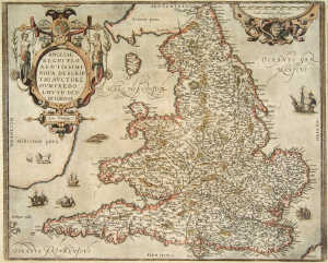
Lot 1
* England & Wales. Ortelius (Abraham), Angliae Regni Florentissimi Nova Descriptio, Auctore Humfredo Lhuyd Denbygiense, 1573 [or later], engraved map, separate ornamental strapwork title and scale-of-distance cartouche, contemp. hand colouring, single worm-trail to lower margin not affectin printed image, approx. 375 x 470 mm, framed and double-glazed, Latin text to verso. (1)
Lot 1
English County maps. Saxton (Christopher & Kip, William), Wiltoniae Comitatus Herbida Planicie, [1637], hand coloured engraved map, strapwork title cartouche, approx. 280 x 350 mm, together with Northamtoniae Comitatus Descriptio, [1637], hand coloured engraved map, strapwork title and scale of distance cartouches, somewhat browned, approx. 285 x 360 mm, together with Pigot & Co. (pub.), Pigot & Co's New Map of England & Wales with Part of Scotland, c.1830s, hand coloured engraved map with calligraphic title, paper repairs to verso, approx. 700 x 530 mm, and Morden (Robert), Darbyshire and Huntingtonshire, [1695 or 1722], together two engraved maps, the former hand coloured, each approx. 360 x 420 mm, plus others related. (7)
Lot 1
English & Welsh Counties. Cary (John), A New Map of Cambridgeshire Divided into Hundreds, 1806, hand coloured engraved map, approx. 550 x 480 mm, together with Morden (Robert), A New and Correct Map of North-Wales, [1722], uncoloured engraved map, approx. 360 x 430 mm, and Morden (Robert), Herefordshire, [1695 or 1722], hand col. eng. map, approx. 360 x 420 mm, plus Blome (Richard), A Mapp if ye County of Mounmouth, late 17th century, uncol. engraved map, approx. 315 x 250 mm, and other county and regional maps of England and Wales by Pigot, Cary, Teesdale, etc. (approx. 33)
Lot 1
Great Britain. Moll (Herman). A New Map of Great Britain, n.d, c. 1720, eng. map hand-col. in outline, plain rectangular title cartouche, inset detail of the Shetland Isles, compass rose, printed historical information, creased where previously folded, dampstained at edges and along centrefold, a few tears, approx. 101 x 63 cm. (1)
-
108737 item(s)/page