

Nares (Sir George S.). Narrative of a Voyage to the Polar Sea during 1875-6 in H.M. Ships 'Alert' and 'Discovery', 2 volumes, 1st edition, London: Sampson Low, Marston, Searle, & Rivington, 1878, xl 395; viii 378, half-titles, 6 photographic plates (woodburytypes, mounted), 5 wood-engraved plates, 3 lithographic plates (one tinted, oological), 2 folding maps, 24 pp. advertisements, toning, a few spots and marks, folding map in volume 1 crudely tape-repaired verso, concomitant staining to p. xl, volume 1 pp. 315-22 nicked at foot, bookplates of Kenn Back, original green cloth, recased and relined, rubbed and marked, 8voQty: (2)NOTESTHE POLAR AND SOUTH AMERICAN LIBRARY OF BRITISH ANTARCTIC SURVEY METEOROLOGIST KENN BACK Arctic Bibliography 12026A.
We found 109182 price guide item(s) matching your search
There are 109182 lots that match your search criteria. Subscribe now to get instant access to the full price guide service.
Click here to subscribe- List
- Grid
-
109182 item(s)/page
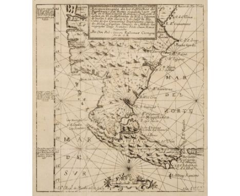
Nodal (Bartolomé Garcia & Gonzalo de). Relacion del viage que por orden de su magestad, y acuerdo de el real consejo de Indias, hicieron los capitanes Bartholome Garcia de Nodal, y Gonzalo de Nodal, hermanos, naturales de Pontevedra, al descrubimento del estrecho nuevo de San Vicente, que hoy es nombrado de Maire, y reconocimiento del de Magallanes, 2nd edition, Cadiz: reimpresso por Don Manuel Espinosa de los Monteros, impressor de la Real Marina, [1769], bound with: Echevelar (Manuel de). J. M. Y J. Instruccion exacta, y util de las derrotas y navegaciones, que se execuan en todos tiempos en la America septentrional, de unos puertos à otros: con las advertencias de sondas, y notas, para ponerlas en pràctica, Cadiz: en la Real imprenta de Marina, 1753 [i.e. 1769?], 2 parts in 1 volume, Nodal: [20] 1-160 159-162 [4] pp., signatures pi2 [par.]-2[par.]4 A-X4 (2[par.]4 and X4 blank), woodcut initial and head-and tailpieces, engraved folding map (titled 'Reconocimiento de los estrechos de Magallanes y San Vicente ... por Don Pedro Texeira Ealbernas', dated 1769), woodcut vignettes in text at pp. 82-3 and 88, ink inscription to title-page verso (possibly a call number; visible recto), filled-in worm track to upper outer corners of signatures pi-E touching a few letters, headlines and page-numbers (the text neatly restored), similar minor repairs to fore margins of signature R-X not affecting text, Echevelar: 41 [3] pp., signatures A-E4 F2, repaired worming in fore margins touching decorative border of title-page, contents washed, bookplate of Kenn Back, 20th-century vellum by A. Cazares of Buenos Aires, 4to (19.3 x 13.6 cm)Qty: (1)NOTESTHE POLAR AND SOUTH AMERICAN LIBRARY OF BRITISH ANTARCTIC SURVEY METEOROLOGIST KENN BACK Acquisition: Victor Aizenman, Buenos Aires, c.1997. Sabin 55935-6 (including the Instruccion); cf. Borba de Moraes II p. 102, Carter Brown II p. 156, Church 386 and Hill (1974) pp. 213-14 for the first edition (of Nodal only). Hill describes the first edition, printed at Madrid in 1621, as 'one of the rarest books on voyages of the seventeenth century ... Copies containing the map are so rare that it is believed to have been suppressed in accordance with the official Spanish policy of secrecy'. 'The work gives an account of the Spanish expedition sent out by order of Philip III, immediately after the return of Schouten's expedition, for the exploration of the Magellan Straits. The brothers Nodal sailed from Lisbon on the 27th of September, 1618, and did not return until July 9th of the following year ... The Strait Le Maire was rechristened S. Vincent, which name it retained for some time on Spanish maps' (Church).
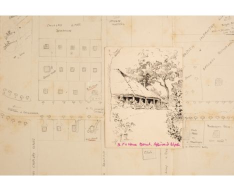
* Baden-Powell (Robert, 1st Baron, 1857-1941). British Army Officer, Writer and Founder of the Scout Movement. A small pen and ink sketch attributed to Baden-Powell of his house at Meerut, North West Province, circa 1900, drawn on a 13th Hussars' notecard with embossed motif to verso, caption in another hand in pink ink, 'BP's House Meerut. Afterwards Nigels', 12 x 9 cm, together with 'A (Guess Work) map of Meerut', early 20th century, pencil on paper in an unidentified hand, featuring streets and street names, identified buildings, crudely drawn figures and trees, etc., Baden-Powell's house seen facing 'our house' [presumably belonging to the Turners], some spotting, 32 x 40 cm, original folds with pencil caption to verso, plus three typed letters signed from Olave Baden-Powell, Pax Hill, Bentley, Hampshire, 12 September to 13 October 1929, all to Mrs Dugdale concerning thank yous and dinners and invitations, etc., 5 pp., 4to/oblong 8vo, plus two printed items: Simla ADC Memorandum of Association. rules, by-laws and general instructions to actors, 1 July 1898; a programme for a theatre performance by the 5th Dragoon Guards at Princess Charlotte of Wales' Theatre, 24 January 1898, featuring Miss Turner, heavily spotted, plus a group of 30 printed Christmas and New Year greetings cards, from the Baden-Powells, mostly with reproductions of Baden-Powell's drawings and printed facsimile signatures, some spotting, various sizesQty: (37)NOTESProvenance: From the Pamela Dugdale Collection. Baden-Powell played the comic part of Wun-Hi in The Geisha in Meerut in 1897 with Mrs Ellen Turner's daughter, (also Ellen), playing the part of Molly Seamore. Thereafter, many of Baden-Powell's letters to mother and daughter were signed 'Wunhi'.
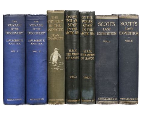
Scott (Robert F.) The Voyage of the 'Discovery', 2 volumes, 1st edition, 2nd impression, London: Smith, Elder, 1905, photogravure frontispieces, folding map contained in each rear pocket, half-tone illustrations, some light spotting, clear tape marks to endpapers, circular armorial bookplates of Richard Henry Tidswell (1848-1928, barrister), top edge gilt, original blue cloth gilt, spine ends slightly rubbed, thick 8vo, together with: Charcot (Jean). The Voyage of the 'Why Not?' in the Antarctic. The Journal of the Second French South Polar Expedition, 1908-1910, 1st English edition, London: Hodder and Stoughton, [1911], half-tone illustrations, a little minor spotting and toning, endpapers renewed, original cloth gilt, spine a little faded and repaired at ends, 4to, Luigi Amedeo of Savoy, Duke of the Abruzzi. On the "Polar Star" in the Arctic Sea, translated by William le Queux, 2 volumes, 1st English editition, London: Hutchinson, 1903. two folding maps in volume 2 rear pocket supplied in facsimile, illustrations, light spotting, public library stamps to title, hinges reinforced, original cloth gilt, rebacked with original spines relaid, a few stains, 4to, Scott (Robert F.) Scott's Last Expedition, 2 volumes, 3rd edition, London: Smith, Elder, 1913, maps and illustrations (illustration at p. 350 in volume 2 detached), some light spotting, endpapers renewed, original cloth gilt, spines a little faded and repaired at ends, thick 8voQty: (7)NOTESTHE POLAR AND SOUTH AMERICAN LIBRARY OF BRITISH ANTARCTIC SURVEY METEOROLOGIST KENN BACK.
Shackleton (Ernest H.). Mon Expédition au Sud Polaire 1914-1917. Traduction de M.-L. Landel, 1st edition in French of South, Tours: Alfred Mame et fils, [1930], photographic frontispiece, similar illustrations throughout (many full-page but counted in pagination), folding map to rear, browning, bookplate of Kenn Back, gilt edges, original pictorial cloth, recased and spine-label added, folio, together with: Scott (Robert Falcon). La "Discovery" au Pôle Sud, 2 volumes, 1st edition in French of The Voyage of the 'Discovery', Paris: Hachette et Cie, 1908, numerous plates and maps, occasional light spotting to text, bookplates of Kenn Back, original yellow cloth lettered in gilt, a few marks, 4to, Amundsen (Roald). Au Pôle Sud. Expédition du "Fram", 1910-1912, 1st edition in French of The South Pole, Paris: Hachette et Cie, 1913, numerous plates, bookplate of Kenn Back, original blue pictorial cloth gilt, 4to, and 14 other foreign-language accounts of polar exploration (mainly Antarctic), including French and Scandinavian translations of English works, authors including Sverdrup, Nansen, Hurley, Ross, Scott and similar, the lot not collated and sold as seenQty: (22)NOTESTHE POLAR AND SOUTH AMERICAN LIBRARY OF BRITISH ANTARCTIC SURVEY METEOROLOGIST KENN BACK
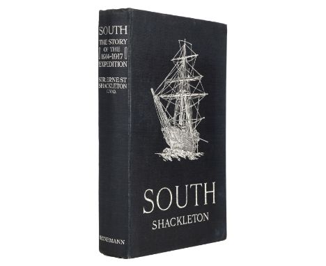
Shackleton (Ernest H.). South. The Story of Shackleton's Last Expedition 1914-1917, 1st edition, 2nd impression, London: William Heinemann, 1919, colour frontispiece, all halftone photographic plates as called for including double-page panorama, folding map, contemporary gift inscription to front free endpaper, bookplate to front pastedown, original dark blue cloth, spine letttered in silver, large pictorial block of the Endurance in silver to front board, upper fore corner of front board bumped, 8voQty: (1)NOTESTHE POLAR AND SOUTH AMERICAN LIBRARY OF BRITISH ANTARCTIC SURVEY METEOROLOGIST KENN BACK The first impression of the previous month was printed on inferior paper which is invariably browned.
![China Journal. A Trip in the Hills beyond Peking, September 1924 [so titled on upper cover], an illustrated manuscript accoun](https://cdn.globalauctionplatform.com/77bc0ec2-9b7d-4928-a674-acd400a80e4f/20c042b5-f3ad-4ddd-baa6-acd400ed5a03/468x382.jpg)
China Journal. A Trip in the Hills beyond Peking, September 1924 [so titled on upper cover], an illustrated manuscript account of a British hiking trip in rural China at a time of civil war, comprising 25 pages including 16 pages of a journal written in pencil and incorporating 2 sketches (‘one of the chief monks standing out to make a tour of the monastery’s demands’ and ‘old font in Guests’ Courtyard’) in an unidentified hand; a further 22 captioned and mounted black and white photographs of the trip on 6 pages, photographs include members of the party, several village scenes including Ho Pei and Hei Leung Kuan, images 8 x 5.5cm or 6 x 10.5cm; a full-page sketch map of the route in pencil with some additional red and blue watercolour; plus 2 full-page drawings, the first in pencil of the ‘Entrance to Ha Lung Kuan’, the second in watercolour and pencil of ‘Guests’ Quarters, Hsi Yu Sen’, small split to foremargins of 2 leaves not affecting text or drawings, contents partly detached in contemporary stapled printed wrappers (Manufactured by Tientsin Press Ltd) with manuscript title to upper wrapper, lacks lower wrapper, oblong small folio (19 x 27.5cm), together with: China, a small photograph album, circa 1916, containing 9 black and white snapshot photographs mounted on rectos, with ink captions and seemingly in the same hand as the journal, showing: Canton, [now Guangzhou] (December 1916), New Custom House under construction; British Consulate building damaged by floods; Chun family temple; Pagoda from British Yamen Gardens [Yamen, administrative offices]; The old British Yamen, now a mess for civil service students; The old British Yamen, grounds; crowded passenger junk; "The Dormouse", houseboat showing Ernest Wilton with others; Chinese servant with dogs; Man in soldier's uniform (pasted to final leaf verso), each 6 x 10.5cm, plus 7 mostly related loose photos but including one later one (creased) showing Indian soldiers in Hong Kong marching on King's Birthday in 1929, contemporary card covers with spine tie, 14.5 x 19.5cm, plus a small partly cut down studio photograph of Sir Edward Colville Collins Wilton, circa 1910, oval-matted in a small leather desk frame, 12.5 x 10cmQty: (3)NOTESProvenance: The British diplomat Sir Ernest Colville Collins Wilton, KCMG (1870-1952), who would seem to be the author/photographer. Wilton had a 30-year relationship with Chinese affairs beginning in 1890. He was employed with the Mission to Tibet in 1903-04, as adviser to Francis Younghusband on Chinese affairs. At the time the photographs in the small album were taken Wilton would have been Acting Consul-General in Canton. By 1920 he had returned to Europe, becoming British Commissioner in Lithuania, and was later appointed Envoy Extraordinary and Minister Plenipotentiary to the Republics of Estonia and Latvia. From 1923-26 he was Chief Foreign Inspector of the Chinese Salt Gabelle, and from 1927-32 he was President of the Saar Governing Commission, in Europe. The trip was certainly undertaken by some people in consular positions, and one photographed woman identified simply as ‘V’ may refer to Violet Evelyn Brown, who Wilton was to marry in 1927. The trip appears to have taken in what is known as The Fragrant Hills, written by an unidentified author. At the beginning the diarist worries that Chang Tso Lin [Zhang Zuolin, a Chinese warlord] will come into the Civil War [i.e. the conflict between Japanese-backed forces based in Manchuria, known as the Fengtians and the Zhili faction, backed by Anglo-US interests] leaving the trains between Peking and Mukden [Shenyang] affected, and thus delaying their trip into the Western hills near Beijing. Since the trains appear to be unaffected they decide their trip can go ahead in spite of all. There are mentions of Mrs Denham and her friend, Mrs Wheatcroft, an artist joining them, plus 'The Lucas''. The diary continues with lists of the provisions and supplies: bacon, whisky, pickles, etc., and a list of 'useful things Mrs Denham likes' including a piece of white linoleum to use as a tablecloth, 'paper napkins instead of linen ones'... The party take the train to Chang Tsin Tien where they change trains and begin their trip from Toli [photo of the travellers in a Toli teahouse] with a walk to Hei Lung Kwan crossing the Lu Li Ho river, and finding it hard going even with donkeys as the river has flooded and several bridges are down. Later they come to large village Nan Chiao 'where there is a good sized temple'. Their departure from the village draws a large crowd, ’foreigners are evidently a rarity in these parts'. 'One passes numerous little coal mines… and all the people are black with coal dust'. They eventually arrive at Chan Kow Yuen to find the temple in ruins. They find another at the other end of the village but it is full of soldiers. They head for a place called Hsi Yu Sen passing through prosperous countryside of buckwheat fields, and find the people friendly. Retracing their steps they see 'a curious little bit of country superstition' when they witness a little girl drop a baby while crossing a stream on stepping stones. When she picks it up she touches the stones and then the baby's head, an action repeated by the mother when she arrives. Their train is full with country people and soldiers 'all however quite well behaved’.

WWII Burma. Burma Victory, issued by the British Ministry of Information, no date, circa 1945, loose leaf title, map and 42 numbered captioned display cards with reproductions of black and white photographs, single pinhole to all four corners of each, title leaf slightly creased and marked, 38 x 30 cm, together with three related contemporary magazines, 'Battered Burma', 'The Chindits', and 'Burma: A Miracle in Military Achievement', a little spotting and creasing, original stapled printed wrappers, slim 4to/folioQty: (4)NOTESFrom the Library of Lt. Col. R.J. 'Bob' Wyatt MBE TD (1931-2019).
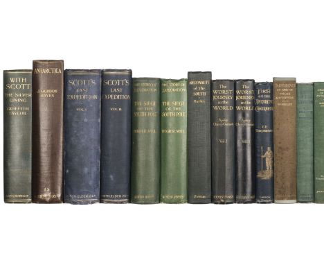
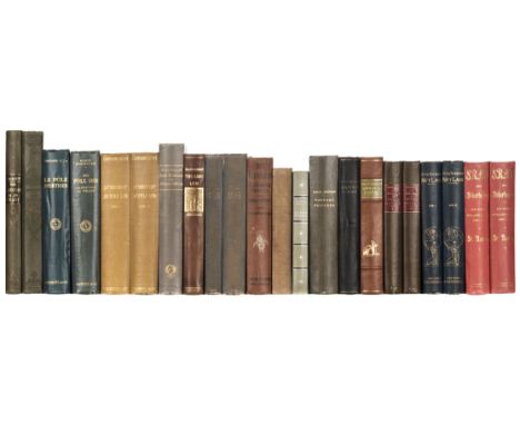
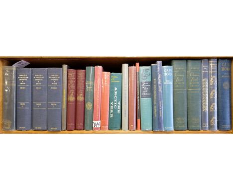
Taylor (Griffith). With Scott: The Silver Lining, 1st edition, 2nd issue, London: Smith, Elder & Co., 1916, all plates as called for, 2 folding maps, half-title and title-page, spotted, library markings to a few pp. and to folding map verso, a few leaves clumsily opened, folding map with closed handling tear, endpapers renewed, bookplate of Kenn Back, original green pictorial cloth, library label removed from spine, partial loss of lettering on front cover, a few marks, 8vo, together with: Borchgrevink (C. E.). First on the Antarctic Continent. Being an Account of the British Antarctic Expedition 1898-1900, 1st edition, London: George Newnes, Limited, 1901, photogravure portrait frontispiece, 3 folding maps, 32 pp. advertisements, pp. xv-16 loose, pp. 41/2 and 121/2 each with crudely repaired tear in gutter and contemporary annotations to margins, occasional pencil markings elsewhere, top edge gilt, original blue cloth lettered and decorated in gold and silver, extremities rubbed, 8vo, Cherry-Garrard (Apsley). The Worst Journey in the World. Antarctic 1910-1913, 2 volumes, 2nd edition, 2nd issue, London: Constable and Company Limited, 1929, numerous plates and maps, spotting, bookplates of Kenn Back, original blue cloth, spines refurbished, 8vo, and 13 others, Antarctic exploration, original cloth (not collated), including Scott, Scott's Last Expedition, 1st edition, 1913 (covers badly water-damaged, staining to outer leaves, endpapers renewed), Joyce, The South Polar Trail, 1st edition, 1929, Hurley, Argonauts of the South, 1st US edition, 1925, Mill, The Siege of the South Pole, 1st edition, 1905, and similarQty: (18)NOTESTHE POLAR AND SOUTH AMERICAN LIBRARY OF BRITISH ANTARCTIC SURVEY METEOROLOGIST KENN BACK

Burke (Edmund). Reflections on the Revolution in France, and on the Proceedings in certain Societies in London relative to that event. In a Letter intended to have been sent to a Gentleman in Paris, 9th edition, London: J. Dodsley, 1791, contemporary tree sheep, neatly rebacked preserving morocco title label, 8vo, together with: Fain (Agathon-Jean-Franc?ois), Memoirs of the Invasion of France by the Allied Armies, and of the last six months of the reign of Napoleon, including his abdication. Written at the command of the Emperor, new edition, London: Henry Colburn, 1834, engraved frontispiece, folding engraved map, 4pp. publisher's list at rear, contemporary half sheep, spine faded, rubbed, 8vo, [Stirling Maxwell, William], Napoleon's Bequest to Cantillon. A Fragment of International History, London: John W. Parker, 1858, title in red & black, top edge gilt, bookplate of Harold John Tennant, near contemporary black half morocco, blind embossed monogram to centre of each board, 8vo,Qty: (3)
Gilpin (William). Observations on Several Parts of Great Britain, particularly the High-Lands of Scotland... made in the year 1776, 3rd edition, 2 volumes in one, London: for T. Cadell, 1808, numerous aquatint plates, generally offset to text, title with ink manuscript signature 'Peter Carmichael 1861' at head, armorial bookplate of Peter Carmichael, 19th century brown diced sheep by J.B. Brechin, Dundee, rubbed with one corner showing, gilt-decorated spine (lightly faded) with gilt-lettered label and minor fraying at head, 8vo, together with: Thomson (James), The History of Dundee ..., Dundee: for the proprietors by Robert Walker, 1847, additional vignette title (lightly toned), with ink manuscript signature 'Peter Carmichael Dec[?] 1846' at head, armorial bookplate of Peter Carmichael, contemporary red half morocco gilt by W. Smith, Dundee, extremities lightly rubbed, some marks, gilt-decorated spine lightly faded, 8vo, plus: Chambers (Robert & William), The Gazetteer of Scotland, 2 volumes, Edinburgh: Thomas Ireland, Junior, 1834, each volume with folding map, that to volume 1 with long closed handling tear, several engraved plates, occasional spotting and toning, each with armorial bookplate Peter Charmichael, red half morocco gilt by W. Smith, Dundee, extremities a trifle rubbed in places, gilt-decorated spines with contrasting labels, 8vo, with: Innes (Cosmo), Scotland in the Middle Ages ..., Edinburgh: Edmonston and Douglas, 1860, 3 maps (2 double-page, one colour), armorial bookplate Peter Carmichael, contemporary brown half morocco by W. Smith, Dundee, spine faded, 8vo, and 6 French books in gilt-decorated leather bindings, including: Les Chasseurs by Gyp, drawings by Crafty, 1888, in red half morocco gilt by Engel & Fils [?]; Le Tour du Monde, edited by Edouard Charton, premiere anne, 1864, in dark green quarter morocco gilt by C.Magnier; Dictionnaire Raisonne du Mobilier Francais ..., by M. Viollet-le-Duc, 3 volumes only (of six), 2nd edition, 1868Qty: (14)NOTESProvenance: Peter Carmichael is possibly the Dundee-based architect (1809-1881).

Weddell (James). A Voyage towards the South Pole, performed in the Years 1822-24. Containing n Examination of the Antarctic Sea, to the Seventy-Fourth Degree of Latitude: and a Visit to Tierra del Fuego, with a Particular Account of its Inhabitants, 1st edition, London: Longman, Hurst, Rees, Orme, Brown, and Green, 1825, iv 276 pp., hand-coloured aquatint frontispiece, 6 aquatint plates, 8 engraved maps, (2 of the plates and 6 of the maps folding and backed on linen as issued), errata slip (tipped to p. iv), plates and maps spotted and offset, one map ('The Polar Part of the Northern Hemisphere') with title shaved, front pastedown with contemporary engraved bookplate incorporating earl's coronet, crest of a griffin and motto of the Order of the Garter, bookplate of Kenn Back to front free endpaper, contemporary sprinkled calf, rebacked to style, board-edges rubbed, 8vo (21 x 12.2 cm)Qty: (1)NOTESTHE POLAR AND SOUTH AMERICAN LIBRARY OF BRITISH ANTARCTIC SURVEY METEOROLOGIST KENN BACK Abbey Travel 609; Hill (1974) p. 322; Sabin 102431. Weddell's expedition 'visited and described the Cape Verde Islands, South Orkney Islands, South Shetland Islands, and South Georgia Islands, wintered in the Falkland Islands, and described Tierra del Fuego, Patagonia, and Montevideo. During their southward sailing, they reached the lowest latitude as yet then recorded. This area explored now bears the name Weddell Sea' (Hill).
![Raleigh (Sir Walter). The Historie of the World... [London: printed for H. Lownes, G. Latham and R. Young, 1628], letterpress](https://cdn.globalauctionplatform.com/77bc0ec2-9b7d-4928-a674-acd400a80e4f/9304bf8b-356f-4466-90e3-acd400ed7358/468x382.jpg)
Raleigh (Sir Walter). The Historie of the World... [London: printed for H. Lownes, G. Latham and R. Young, 1628], letterpress title with engraved portrait, 5 folding engraved maps only (of 6, also lacking the additional engraved title and the 2 battle plans), maps detached, 'A Description of the Land of Gosen' map torn with some loss of text to top left, first map reinforced to verso, most with frayed margins, 'The Minde of the Front' leaf at front repaired, front endpaper repaired, small insect predation to title, occasional light spotting and soiling, first two leaves with water stains, early annotations to rear endpaper, later sprinkled calf, a little rubbed with small repairs, stains and wear to corners, folioQty: (1)NOTESSTC 20640. Sold with all faults not subject to return.

Christensen (Lars). Such is the Antarctic, 1st edition in English, London: Hodder and Stoughton, 1935, plates, bookplate of Kenn Back, original cloth, dust jacket (price-clipped, rubbed and toned, a few closed tears), 8vo, together with: Polunin (Nicholas). Circumpolar Arctic Flora, 1st edition, Oxford: Clarendon Press, 1959, text-illustrations, bookplates (Marshall Laird and Kenn Back), original cloth, dust jacket, 8vo, Barclay (W. S.). The Land of Magellan, 1st edition, London: Methuen & Co. Ltd., 1926, plates, spotting to outer leaves and edges, bookplate of Kenn Back, original red cloth, dust jacket (with loss), 8vo, Howard (Basil). Rakiura. A History of Stewart Island, New Zealand, 1st edition, Dunedin: A. H. and A. W. Reid, 1940, plates, folding map, bookplate of Kenn Back, original cloth, dust jacket (repaired verso), 8vo, and about 100 others, mainly Antarctic and South American exploration, 20th century, in the dust jacketsQty: (5 shelves)NOTESTHE POLAR AND SOUTH AMERICAN LIBRARY OF BRITISH ANTARCTIC SURVEY METEOROLOGIST KENN BACK
Thomson (C. Wyville). The Voyage of the 'Challenger'. The Atlantic, a preliminary account of the general results of the exploring voyage of HMS 'Challenger' during the year 1873 and the early part of the year 1876, 2 volumes, 1st edition, Macmillan & Co, 1877, engraved portrait frontispiece in volume 1 and folding colour map frontispiece in volume 2, 43 plates, maps and charts, including some folding, wood-engraved illustrations to text, some spotting, lacks half-title to volume 1, large ink name stamp to frontispiece recto and half-title, with some see-through, original green cloth gilt, somewhat rubbed and soiled, frayed at spine ends and along lower joint of volume 1, large 8vo, together with: Spry (W.J.J.), The Cruise of Her Majesty's Ship 'Challenger', Voyages over Many Seas, Scenes in Many Lands, 2nd edition, Sampson Low, 1877, folding engraved map and plates, inner hinges cracked, original cloth gilt, rubbed and frayed at spine ends and along lower joint, all 8vo, plus: A Narrative of the Loss of the Kent East Indiaman, by Fire, in the Bay of Biscay, on the 1st of March, 1825, in a letter to a friend, by a passenger, Edinburgh: Waugh & Innes, 1825, 78 pp., untrimmed, a little spotting, contemporary presentation inscription to front flyleaf, contemporary boards, some soiling and edge wear, paper reback and title label to upper cover, 12mo, plus: Maxim (Hiram), A New System for Preventing Collisions at Sea, printed for the author by Cassell & Co, 1912, frontispiece and illustrations to text, three related leaflets at rear, tipped in and loose, signed presentation inscription from the author to J. Robinson, dated June 1914 and inscribed to front free endpaper, a little dampstaining to fore-margins of first few leaves, original cloth gilt, slim 8vo, and: Plimsoll (Samuel), Our Seamen, An Appeal, 1st edition, Virtue & Co, 1873, 58 heliotype plates including 4 supplied in facsimile, original cloth, soiling and edge wear, cloth reback, 4to, plus other maritime interest including three accounts of the sinking of the Titanic and various pamphlets and reportsQty: (44)
Goebel (Julius). The Struggle for the Falkland Islands. A Study in Legal and Diplomatic History, 1st edition, New Haven: Yale University Press, 1927, library plate, blind stamps and deaccession markings of Providence Public Library, bookplate of Kenn Back, original cloth, 8vo, together with: Hubbard (Mrs. Leonidas, Jr.). A Woman's Way through Unknown Labrador, 1st edition, New York: McClure Company, 1908, plates, folding map, bookplate of Kenn Back, original red cloth, 8vo, Murphy (Robert Cushman). Oceanic Birds of South America, 2 volumes, 1st edition, New York: The Macmillan Company, the American Museum of Natural History, 1936, plates, bookplate of Kenn Back, original cloth, 4to, [Antarctica]. The Antarctic Pilot, 4th edition, [London]: Published by the Hydrographer of the Navy, 1974, bookplate of Kenn Back, original cloth, folio, and about 100 others, mainly Antarctic and South American travel and reference, 20th century, original clothQty: (6 shelves)NOTESTHE POLAR AND SOUTH AMERICAN LIBRARY OF BRITISH ANTARCTIC SURVEY METEOROLOGIST KENN BACK

Scott (Robert Falcon). Scott's Last Expedition, 2 volumes, 1st edition, London: Smith, Elder & Co., 1913, numerous colour and black & white plates & maps, bookplate of Sir John Henry Butters to front pastedowns, occasional minor spotting, slight toning throughout, partial split to rear inner hinge of volume 1, original gilt lettered cloth, top edges gilt, rubbed to head & foot, 8vo, together with; Buxton (Edward North), Two African Trips, 1st edition, London: Edward Stanford, 1902, previous owner pencil and ink inscription to front endpapers, numerous black and white illustrations, lacking folding map to rear pocket, original pictorial cloth, covers rubbed & toned, spine defective, 8vo, and Williams (Harry), Ceylon Pearl Of The East, 1st edition, London: Robert Hale Limited, circa 1960, ink inscription to title page, original cloth, spine & covers rubbed to head and foot, 8vo, plus other travel and UK topography including approximately 30 Baedeckers travel guides, mostly original cloth, G/VG, 8voQty: (5 shelves )
Arundell (Francis Vyvyan Jago). Discoveries in Asia Minor; including a Description of the Ruins of Several Ancient Cities, and especially Antioch of Pisidia, 2 volumes, 1st edition, London: Richard Bentley, 1834, half-title to volume 1, folding lithographic map, 10 lithographic plates, advertisement leaf (volume 1, 2A4) discarded, toning, damp-staining to plates (and occasionally elsewhere), neat repair to verso of map and to margin of volume 2 leaf 2N5 (the latter just affecting text to no loss of legibility), near-contemporary dark blue half calf, 8vo (20.9 x 13 cm)Qty: (2)NOTESProvenance: Edwin Freshfield (1832-1918), solicitor and antiquarian (bookplates). 'In 1861 [Freshfield] ... married Zoe Charlotte Hanson, daughter of J. F. Hanson, the Levant Company's representative in Smyrna. Edwin's travels in that part of the world, which he first visited in 1854–5 after he left Cambridge, and his marriage gave him a lifetime interest in Greece and the surrounding areas' (ODNB). Atabey 37; Blackmer 49.

Bartlett (W. H., William Purser, & others, illustrators). Syria, the Holy Land, Asia Minor, etc. Illustrated. In a Series of Views drawn from Nature. The Descriptions of the Plates by John Carne, 3 volumes, 1st edition, London: Fisher, Son, & Co., 1839, engraved vignette title-pages, 117 plates, 2 maps, plates toned and occasionally spotted, all edges gilt, original green quarter morocco, green cloth sides, a few marks, 4to, together with: Laborde (Léon de). Journey through Arabia Petrae, to Mount Sinai, and the Excavated City of Petra, the Edom of the Prophecies, 1st edition in English, London: John Murray, 1836, 25 lithographic or engraved plates including frontispiece, folding map, occasional spotting and offsetting, contemporary engraved bookplate (John and Elizabeth Portal), contemporary half calf, 8vo (20.9 x 13 cm), Faithfull (Emily). Three Visits to America, 1st edition, Edinburgh: David Douglas, 1884, 2 pp. advertisements, inscribed by the dedicatee Richard Peacock on the half-title, Selbourne Library ink-stamp to verso of title-page and to p.51, original green cloth, spine rolled, 8vo, and 7 others (not collated), including Fêtes et courtisanes de la Grèce, 4 volumes, 1801 (contemporary half calf), Trevelyan, Cawnpore, 1st edition 1865 (modern half morocco), Marryat, A Diary in America, Paris, 1839 (family copy: bookplate of Horace Marryat; contemporary half calf), and similarQty: (16)NOTESBlackmer 291 (Bartlett), 930 (Laborde, erroneously calling for 26 plates).
![Bowen (Emanuel). A Complete System of Geography, 2 volumes, 1st edition, London: William Innys [and others], [1744]-1747, xi](https://cdn.globalauctionplatform.com/77bc0ec2-9b7d-4928-a674-acd400a80e4f/1037e1c4-4dc6-4460-8287-acd400ec83b9/468x382.jpg)
Bowen (Emanuel). A Complete System of Geography, 2 volumes, 1st edition, London: William Innys [and others], [1744]-1747, xi [1] xxviii 1013 [3], [4] 804 [24] pp., title-pages in red and black, 2 engraved plates, 69 engraved maps (complete as list; mainly double-page; one map, 'The World in Two Hemispheres', double-page and folding), variable browning, a few contemporary ink-stamps to margins (crest of a stag's head), volume 1 with damp-staining to lower margins from about p. 585, gradually extending and with increasingly noticeable weakening and fraying of the paper, affecting bottom line of text towards rear, and affecting about half the maps in the volume (nos. 16-30 of 30; numbering from 'A List of the Maps and Plates' to front of volume) but encroaching on plate-marks in maps 29-30 only (Poland/Lithuania and Hungary), signature 11U bound back-to-front and upside-down, volume 2 with pale markings to a few maps, probably damp-related but any related staining minimal and limited to light damp-staining in lower margins of a few maps including nos. 60 (Carolina), 61 (Virginia and Maryland) and 62 ('Pensilvania, New York, New Jersey and New England'), small closed tear in map 66 (Jamaica), numbers 70 (Antigua) and 57 (West Indies) each with hole in lower margin, number 67 (North Pole) with small hole in image affecting caption only, small section of text-leaf 8X2 adhering to previous leaf obscuring text, holes in 9E2 and 9P1 to loss of text, 9F1-2 partially stuck together, final few signatures (9R-10A) frequently stuck together at a single point with concomitant loss of text, ownership inscriptions 'Clutterbuck, Ap. 1813' to title-pages, volume 1 with contemporary ownership inscription 'Sparrow' and price paid (3-3-0) to front pastedown and early pen-trials to endpaper, red-sprinkled edges, contemporary calf, joints cracked, loss to spine-ends, rubbing and stripping to sides, wear to corners, folio (41.8 x 25 cm)Qty: (2)NOTESESTC T140529; Tooley, Maps and Map-Makers pp. 55-6. A rare complete copy of Bowen's imposing atlas, based on the fourth edition of Moll's Complete Geography; variant, with the dedication signed 'The authors' rather than Stephen Whatley. The first volume is restricted to Europe, while the second concerns the rest of the world and contains some 20 maps of North and South America and the West Indies, as well as a map of the North Pole.
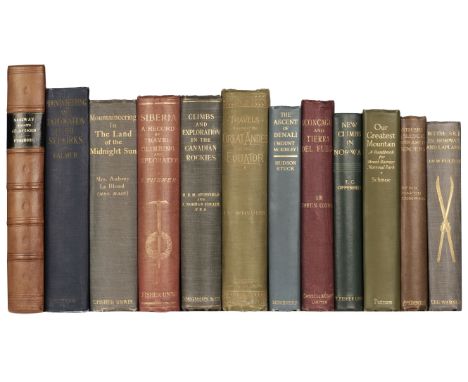
Conway (Martin). Aconcagua and Tierra del Fuego. A Book of Climbing, Travel and Exploration, 1st edition, London: Cassell and Company, Limited, 1902, 19 plates, folding map, 16 pp. advertisements, autograph letter signed from the author to 'My dear Allbutt', probably Sir Thomas Clifford Allbutt (1836-1925), physician and mountaineer, original dark red cloth, pale mottling, 8vo, together with: ibid. With Ski and Sledge over Arctic Glaciers, 1st edition, London: J. M. Dent & Co., 1898, 12 plates, Conway's clipped pencilled signature laid in, original cloth, dust-soiled, 8vo, Forbes (James D.). Norway and its Glaciers, visited in 1851, 1st edition, Edinburgh: Adam and Charles Black, 1853, 10 chromolithographic plates including frontispiece, 2 maps (one folding), toning, a few spots and marks, frontispiece working loose, folding map with short split to one fold and retrievable paper-disruption to intersection of folds, original cloth, rebacked in morocco, large 8vo, Turner (Samuel). Siberia. A Record of Travel, Climbing, and Exploration, 1st edition, US issue, London: T. Fisher Unwin, 1905, publisher's slip ('Edition for America, Imported by A. Wessels Company') tipped to title-page, frontispiece, 2 folding maps, illustrations throughout, front inner hinge split but firm, top edge gilt, original red pictorial cloth gilt, spine faded, upper fore corner of front board bumped, 8vo, Stutfield (Hugh E. M., & J. Norman Collie). Climbs and Exploration in the Canadian Rockies, 1st edition, Longmans, Green and Co., 1903, 52 plates including frontispiece, folding map, 40 pp. advertisements, original cloth, mark across front board, 8vo, Le Blond (Elizabeth Alice Frances). Mountaineering in the Land of the Midnight Sun, 1st edition, London: T. Fisher Unwin, 1908, 64 plates, folding map, 4 pp. advertisements, original pictorial cloth, 8vo, Stuck (Hudson). The Ascent of Denali (Mount McKinley), 1st edition, New York: Charles Scribner's Sons, 1914, 34 plates, folding map, original pictorial cloth, 8vo, Oppenheim (Edwin Camillo). New Climbs in Norway, 1st edition, London: T. Fisher Unwin, 1898, frontispiece, illustrations in text, top edge gilt, original pictorial cloth, spine rolled, 8vo, and 4 others on Scandinavian and American mountaineering (not collated: Palmer, Mountaineering and Exploration in the Selkirks, 1st edition, 1914; Whymper, Travels amongst the Great Andes of the Equator, 2nd edition, 1892, without supplement; Schmoe, Our Greatest Mountain: A Handbook for Mount Rainier National Park, 1925; Fulton, With Ski in Norway and Lapland, 1891), also a carton of approximately 25 other mountaineering titles, 19th and 20th centuryQty: (12 volumes and a carton)NOTESNeate C99 (Conway, Acocncagua), C108 (Conway, With Ski and Sledge), F34 (Forbes, 'a great classic'), T72 (Turner), S177 (Stutfield, 'one of the classics of the Canadian Rockies'), L24 (Le Blond, 'first ascents in the Lyngen peninsula'), S176 (Stuck), O12 (Oppenheim).
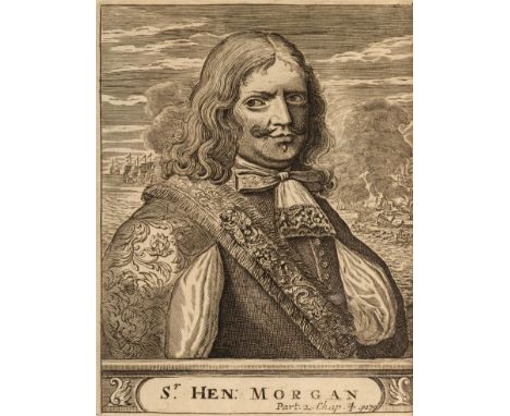
Exquemelin (Alexandre Olivier). The History of the Bucaniers of America; from the First Original down to this Time; written in several Languages; and now Collected into one Volume ... The Third Edition, London: for Tho. Newborough, John Nicholson, and Benj. Tooke, 1703, 3 parts in 1 volume, 8 engraved plates (all folding), 7 engraved maps (all folding), 10 engraved maps in the text (all but one full-page), woodcut coastal profiles and other illustrations in text, text-leaves browned, large map ('A Description of the South Sea & Coasts of America') trimmed to loss of all land south of the Tropic of Capricorn and the decorative cartouche, front free endpaper working loose, contemporary panelled calf, front board near-detached, rear joint cracked at head and foot, tips bumped and worn, 8vo (19.2 x 11.5 cm)Qty: (1)NOTESESTC T145511 (six copies in UK libraries); Sabin 23485; cf. Borba de Moraes I pp. 254-6 and Hill (1974) pp. 99-100 for other editions. 'Exquemelin, or Esquemeling, published his De Americaensche Zee Roovers in Amsterdam in 1678 ... Perhaps he never imagined the fabulous success of his book, which became the prototype for all the literature of pirates and buccaneers ever printed in all languages, and for the Hollywood productions on the subject, to this day' (Borba de Moraes). The plates include portraits of pirates Sir Henry Morgan, Roche Brasiliano and François l'Ollonais, and the maps depict Panama and environs, the Gulf of Nicoya and the Golfo Dulce (both in Costa Rica), and 'The English Gulfe lying a little to the Northward of Magallanes Straights', in addition to the large map of Central and South America.

Faulkner (Sir Arthur Brooke). A Treatise on the Plague, designed to prove it Contagious, from Facts, collected during the Author's Residence in Malta, when visited by that Malady in 1813, 1st edition, London: for Longman, Hurst, Rees, Orme, and Brown, by S. Y Griffith, Cheltenham, 1820, pp. [14] [v]-xxxvi 277 [1] 43, half-title, engraved folding map of Malta, engraved folding plan of Valetta, toning, plan browned on one panel, edges sprinkled blue, contemporary sprinkled half sheep, embossed light green paper sides, rubbed and marked, 8vo (21.2 x 12 cm)Qty: (1)NOTESInscribed 'From William Willoughby Cole Faulkner, to Henry Cole Faulkner, 1876, Alexandria, Egypt' on the front free endpaper,
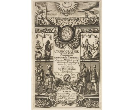
Heylyn (Peter). Cosmographie, in Four Books. Containing the Chorographie and Historie of the Whole World, and all the Principal Kingdoms, Provinces, Seas, and Isles thereof ... With an accurate and an approved Index ... much wanted and desired in the former, and now annexed to this last Impression, Revised and Corrected by the Author himself immediately before his death, London: Anne Seile, 1666, imprimatur leaf not present, additional engraved title stating 3rd edition and with imprint 'London: Printed for Philip Chetwind, 1666' and early signature to upper margin, letterpress cancel title in red & black, also with another letterpress title printed in black stating 3rd edition and with imprint 'London: Printed for Philipp Chetwind, 1665', four folding engraved maps dated 1666 (Europe, Asia, Africa, and Americas), map of Americas slightly close-trimmed and frayed to lower edge, divisional titles present (with varying imprints Philip Chetwind 1665 & 1662), lower outer blank corner of 3Z6 torn away, occasional very light damp stains mostly to upper outer corners or at head, contemporary blind panelled calf, foot of spine worn, folioQty: (1)NOTESWing H1691; Sabin 31655.
Manuscript atlas; French. Course-book produced by Emélie Collombel, pupil at the Pensionnat de la Miséricorde, Rouen, c.1830-48, 42 wove-paper leaves (watermarked 'De Canson frères'), including 35 leaves of fair-copy notes and exercises in penmanship, French composition, spelling and grammar, arithmetic, French literature ('Tableau de la litérature au siècle de Louis XIV de 1628 à 1762'), and French history ('Tableau sympathique des rois de la troisième race dite des Capétiens'), decorated with elaborate calligraphic headings and initials in gilt and colours (many in the medieval style) including title-page, the remaining 7 leaves with maps comprising a double-hemispheric world map, France, Europe, Asia, Africa, the Americas, and Oceania, on rectos only throughout, book-label (P. A. Bazirguian) to front pastedown, all edges gilt, contemporary binding of copper-effect patterned paper boards, roan backstrip, gilt device to front board, wear to extremities, oblong folio (45.9 x 29.6 cm)Qty: (1)
![[Brown, R. N. Rudmose, & others]. The Voyage of the "Scotia". Being the Record of a Voyage of Exploration in Antarctic Se](https://cdn.globalauctionplatform.com/77bc0ec2-9b7d-4928-a674-acd400a80e4f/cedc62b8-72c5-4c4e-b57d-acd400ebe929/468x382.jpg)
[Brown, R. N. Rudmose, & others]. The Voyage of the "Scotia". Being the Record of a Voyage of Exploration in Antarctic Seas, 1st edition, Edinburgh: William Blackwood and Sons, 1906, half-title, all halftone photographic plates as called for, 3 maps (2 folding), occasional spotting, frontispiece working loose, one map with closed handling tear, coated blue endpapers, top edge gilt, original grey pictorial cloth, lettering worn away on spine as often, lower fore corners of boards bumped, 8vo, together with 2 other copies, both 1st editions, one in the same pictorial binding (heavy spotting to text, handling tear to folding map, occasional annotations, ink-stamp of one Juan Carlos Amedeo to title-page, bookplate of Kenn Back, lettering worn away on spine, vignette on front board partially abraded), the other in a secondary plain green cloth binding (heavy spotting to text, plates toned, plates hand-numbered throughout, other annotations, ownership inscription to title-page)Qty: (3)NOTESTHE POLAR AND SOUTH AMERICAN LIBRARY OF BRITISH ANTARCTIC SURVEY METEOROLOGIST KENN BACK
Scoresby (William). An Account of the Arctic Regions, with a History and Description of the Northern Whale-Fishery, 2 volumes, 1st edition, Edinburgh: Archibald Constable, 1820, half titles, folding engraved frontispieces, 22 engraved plates including 3 folding maps and charts (first map with short closed tear along fold), 2 plates numbered XII, 3 folding tables, bound without advertisement leaf, occasional light spotting, offsetting to titles, bookplate of Alexander Browne, Callaly Castle (in Northumberland), contemporary brown calf, spines with green labels and anthemion decorations in blind, joints cracking, 8voQty: (2)NOTESArctic Bibliography 15610; Lande 2036; Sabin 78167. Classic early work on Arctic exploration. "The first volume of this work relates to the progress of discovery in the Arctic regions, and the natural history of Spitzbergen and the Greenland sea, the second is devoted to the whale-fishery as conducted in the seas of Greenland and Davis's Strait. Mr. Scoresby, the commander of a Greenland whaler, has here displayed much judicious and active observation, combined with no ordinary share of acquired knowledge and scientific attainment, and prompted by an ardent and generous zeal for useful discovery." (Sabin).
Stanford (Edward, publisher). Stanford's London Atlas of Universal Geography, 4th edition: quarto edition, London, 1892, half-title (spotted), 48 colour maps, a few leaves at front edge-frayed, gutta percha failing with first few leaves detached, all edges gilt, contemporary maroon half morocco, rubbed and marked with some wear, gilt lettering to spine and front cover, 4to, together with: Philip (George and Son, publisher), Philips' Select Atlas of Modern Geography ..., edited by William Hughes, London, 1859, 23 colour maps, and one colour diagram (complete as list), 2 pp. publisher's advertisements at rear, occasional soiling (mainly to margins) and edge-tears, hinges cracked, original cloth gilt, covers partially darkened with some marks, spine darkened, some wear to extremities and rear joint, slim 4to, plus two others: Atlas Geografico Ibero-Americano, and Espana Regional (map volume only), both defectiveQty: (4)
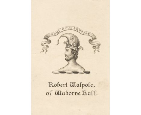
Walpole (Robert). Memoirs relating to European and Asiatic Turkey, and Other Countries of the East, edited from Manuscript Journals, 2nd edition, London: Longman, Hurst, Rees, Orme, and Brown, 1818, xxii, 615 pp., engraved map frontispiece, title-page vignette, 6 engraved plates of which one double-page, 3 engraved plans, 4 etched plates forming a 'panoramic view of Athens', list of plates (on slip, tipped in as issued), maps and plans spotted and browned, marginal tear to H1-2, early catalogue description of another copy mounted to p. iii partly obscuring heading and with related annotation dated 1880 below, marginalia in the same hand to p. 150, stitching broken between quire 4G and penultimate quire 4H, loose in original boards, 4to (27.8 x 22 cm)Qty: (1)NOTESProvenance: Robert Walpole of Waborne Hall, probably the author, with bookplate. Cf. Atabey 1310 and Blackmer 1762 for the first edition (1817).
![War Office. Military Report on Somaliland. 1907. Volume I. Geographical, Descriptive, and Historical [Volume II. Routes], 2 v](https://cdn.globalauctionplatform.com/77bc0ec2-9b7d-4928-a674-acd400a80e4f/f18a5da5-e55c-4cf3-97d5-acd400eca152/468x382.jpg)
War Office. Military Report on Somaliland. 1907. Volume I. Geographical, Descriptive, and Historical [Volume II. Routes], 2 volumes, London: His Majesty's Stationery Office, 1907, vi 279, xix [1] 652 pp., volume 1 with 15 halftone photographic plates, folding table (at volume 1 pp. 77/8), errata slip tipped to title-page, index map to front pastedown, and 3 folding maps in end-pocket, volume 2 with 5 folding maps (facing pp. 112, 281, 294 and 361, and in end-pocket), ownership inscriptions 'R. G. Turrall, Berbera, Oct. 1920' to volume 1 front free endpaper and volume 2 front pastedown, both volumes in original printed boards, volume 1 neatly rebacked in sheep, volume 2 with original tan cloth backstrip, a little wear to board-edges of both volumes, volume 1 front board marked, 8vo (17.5 x 12 cm and 19.6 x 12 cm)Qty: (2)NOTESProvenance: Major Rupert Guy Turrall DSO MC (1893-1988), with his ownership inscriptions. Turrall was commissioned into the Royal Engineers in 1914 and served with the New Zealand division in the Dardanelles campaign (1915), and was twice mentioned in despatches for his actions on the Balkan front (1916-19). After the war he completed his degree in geology and astronomy at Cambridge, and worked as a geophysicist. In 1939 he was commissioned into the Intelligence Corps and was awarded the Military Cross for his service with the Sudan Frontier Force in Abyssinia. He was then recruited by Special Operations Executive Force 133, serving in Crete, before transferring in 1944 to the Chindits in Burma. In September of that year he joined SOE Force 936, his achievements including a highly successful attack on the Japanese Kenpeitai headquarters at Kyaukkyi. A highly eccentric character, he has been identified as a likely model for Apthorpe in Evelyn Waugh’s Sword of Honour trilogy. Rare: no other set traced in auction records, and a handful traced in libraries, some apparently comprising one volume only. The folding maps in end-pockets are titled as follows: Sketch Map of Somaliland; Geological Map of British Somaliland, supplied by R. G. Edwards Leckie; Map of a Portion of Somaliland (opening to 76 x 77 cm); Route Diagram to accompany Vol. II Military Report on Somaliland.
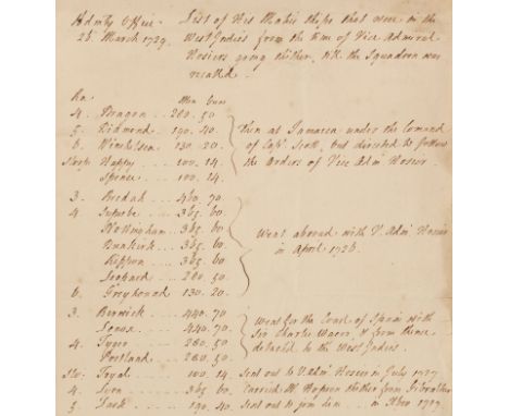
* West Indies. "List of His Majesties Ships that were in the West Indies from the time of Vice Admiral Hosiers going thither, till the Squadron was recall'd, Admiralty Office, 26 March 1729", single-page manuscript listing British Navy ships in order including Dragon, Diamond, Winchelsea ... "then at Jamaica under the Command of Capt. Scott, but directed to follow the Orders of Vice Adm. Hosier", few old folds, folio, together with: America - Townshend (Charles, 2nd Viscount, 1674-1738), Report believed to have been made to Charles Viscount Townshend, circa 1720s, eight-page manuscript report by an unknown hand regarding British strength of defence in North America in relation to the French, "Sir, I shall reduce the subject of yours to to questions and answer them as well I can: The first, if our strength in North America be as itis given out in the proportion of ten to one to that of the French what just cause of fear can we have from their late measures; the next supposing these fears well grounded, is there a remedy in our power", " I say supposing this scheme reduc'd to practice and speedily put in execution the French settlements can not increase and if they should they will be in some measure subservient to and dependent upon ours. For thus our united strength, our situation and possession of all that coast, our easy navigation, quality and quantity of all sort of manufacture requisite for the Indian trade give us so many advantages over them that all the savage inhabitants dreading our power would court our friendship and the French themselves depend on a good understanding with us for every foot of land they may hereafter be possess'd of in North America. And I am firmly persuaded that the possession of so considerable and real a strength abroad as this would give would add weight to our force and measures on this side...", light dust-soiling, od folds, folio, with a small folding engraved map of 'South America, drawn from the best maps, by T. Jefferys, Geographer...' from the Gentleman's Magazine, 1749,Qty: (3)NOTESProvenance (first item): Townshend Heirlooms: Historical Papers (of Raynham Hall, Fakenham), lot 499. Sotheby, Wilkinson & Hodge: London, Catalogue of valuable printed books, autograph letters, and historical documents: comprising the Townshend papers, forming part of the Townshend heirlooms (sold by order of the court), Monday, July 14-16th, 1924. Vice Admiral Frank Hosier (1673-1727) saw distinguished action against the Spanish off Cartagena in 1711. He became Vice-Admiral in 1723 and in March 1726, was sent to command a squadron on the Jamaica Station with orders to prevent Spain from shipping its treasures home. At first, Hosier met with success in his Blockade of Porto Bello. He was under orders not to attempt a capture of the town, which he could have done with relative ease but was forced to loiter and cruise on the Breda off Vera Cruz, which was a mosquito-infested coast. Yellow fever broke out and Hosier himself died, as did between 3,000 and 4,000 of his sailors.

Baines (Edward). The History of the County Palatine and Duchy of Lancaster, 2 volumes, new revised & improved edition, edited by John Harland, London: George Routledge & Sons; Manchester: L.C. Gent, 1868-70, half-titles, folding engraved map with printed colour (spotted), wood engraved illustrations and decorative initials, O4 torn to lower outer blank corner & repaired, marbled endpapers with later brown buckram hinges, all edges gilt, contemporary tree calf, both volumes with buckram rebacks, preserving original gilt decorated spines, contrasting morocco labels, some wear to extremities, 4to, together with: Wright (George Newenham & Allen, Thomas), Lancashire, its History, Legends, and Manufactures, 2 volumes in one, London: Peter Jackson, Late Fisher, Son, & Co., [1844], engraved frontispiece and additional decorative title to each volume (vol. 1 with stain to lower inner corner of frontispiece & additional title), folding map and numerous engraved plates, occasional scattered spotting, contemporary half calf, gilt decorated spine with deficient title label, lacking upper board, lower joint split, worn, 4to, and The History of Lancashire, by J. Corry, volume 2 only, London: George B. Whittaker, 1825, numerous engraved plates, scattered spotting, contemporary half calf, lacking spine and upper board detached, worn, 4toQty: (4)

Booth (Charles). Life and Labour of the People in London, 3rd series: Religious Influences only, London: Macmillan, 1902, 19 folding colour linen-backed maps (of 20? lacking the general poverty map of London), a little light soiling, library blindstamps, top edge gilt, original vellum gilt, a little rubbed with some soiling, 8vo, together with Smith (Edward). A Guide to the Construction and Management of Workhouses; together with the Consolidated Order as amended by subsequent orders of the Poor Law Board, 1st edition, London: Knight and Co., 1870, advertisements at end, small tear and chip to dedication leaf, some light spotting, original blindstamped cloth, spine a little darkened and rubbed, 8vo, with others including Charles Booth's Life and Labour of the People in London, volumes I & IV-VII only, 1892-96, The Aged Poor in England and Wales, 1894, Reports of Special Assistant Poor Law Commissioners on the Employment of Women and Children in Agriculture, 1843 and Henry Mayhew's London Labour and the London Poor, 3 volumes, 1851 (volumes II & III text incomplete) and London Labour and the London Poor, 3 volumes, 1861 (lacking map called for in volume 3?; a volume 4 'Those that Will Not Work' published in 1862 not present)Qty: (23)


Cruchley (G. F.). Cruchley's County Atlas of England & Wales..., 1875, calligraphic title, index, a general map of England & Wales and 46 uncoloured double-page lithographic maps (complete as list), gutta-percha weak with a few maps near detached, hinges cracked and weak, contemporary blue cloth gilt, worn at extremities, 8vo, together with another copy dated 1863, with contemporary outline colouring, but lacking spine and disbound, with Hall (Sidney). A Travelling Atlas of the English Counties, Chapman and Hall, circa 1875, printed title and index, title with closed tear, 46 lithographic maps with contemporary outline colouring, including four folding (Ireland, Scotland, Wales & Yorkshire), complete as list, some pencil annotations to verso of each map, 3 maps (Cambridge, Cheshire and Cornwall) with small holes to upper corners, slight spotting but largely confined to pastedowns and endpapers, contemporary limp morocco gilt, heavily worn and frayed,Qty: (3)

A collection of antique London related ephemera to include;Plan of the Proposed Improvements at Charing Cross, St. Martin’s Lane and Entrance to the Strand, drawn by Basire and published by Hansard for the House of Commons, 12th May 1826. Size 49 by 40 cm., scale 100 feet to the inch. On paper that has been pasted on card. Some hand-colouring. A very detailed map covering an area south from St.Martins Street and Chandos Street to Charing Cross and the Strand, with plans for the Royal Academy facing the National Gallery where Trafalgar Square is now. Damp staining has affected three edges and parts of the map. Plan for a New Street Connecting the District Around Belgrave Square with the Houses of Parliament and the Courts of Law by Rigby Wason. Lithographed by Standidge and published for the House of Commons 1845. On paper size 82 by 33 cm. Scale 150 feet to the mile. An early plan for what eventually became Victoria Street. The outline of the new roads is added in colour to the existing street plan. Has been folded.3 ward maps from Northouk’s History of London 1772, uncoloured.The South Side of Pall Mall showing the houses on the sites of the Athenaeum and other clubs, adapted from a drawing by John Coney, 1796. Pencil on board, probably early 20th century.

A collection of antique maps of India and surrounding areas, to include; Map of India or Hindoostan engraved by J Russell, published by Arrowsmith, London 1805. On paper, size 34 by 26 cm. with one central fold. Scale approximately 180 miles to the inch. Uncoloured. Inde, a map engraved by Giraldon Bovinet, published by Renouard, Paris circa 1850. On paper size 40 by 27 cm. Scale 150 Hindustan Cos to the inch. Hand-coloured. A Plan of Madras and Fort St. George. Engraved by John Andrews and published by John Stockdale, London 1771. On paper size 35 by 25 cm. A key to the left of the map provides information on ten major features of the city including Fort St. George, the Governors House, Custom House, the Powder Magazine, the city gates and the ‘Black Town’ Map of India and the Mutiny 1857. Engraved by Schiéble and published with the Journal Amusant, Paris October 3rd 1857.

A collection of antique late 19th / early 20th century Edwardian children's jigsaw puzzles / jig-saws. To include a rare McLoughlin Bros ' Dissected Map Of The United States ' puzzle, Mammoth puzzle, several made-up wooden jigsaw puzzles and other items. Interesting collection. Completeness not guaranteed.


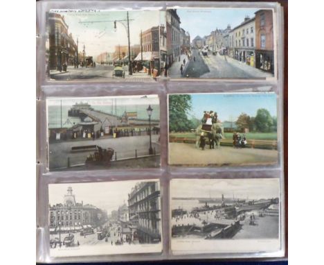
Postcards, a mixed UK topographical and subject collection of approx. 350 cards. UK topographical mostly printed and with many street scenes inc. West Ham, Crawley, Level Crossing Barking, Farringdon (3), Biddenden, Dorking, Small Hythe, Wrexham, Winslow, Willesden Green, Redhill, Balcombe Tunnel, Ealing, Pembroke Dock etc. Subjects inc. Hunting (Drummond), hold-to-light, (Gruss Aus Berlin), 'Ficolax' fruit laxative (5), Deckle edge type military badges (Irish Guards, On War Service etc) (8), embroidered silks (RAMC & sentimental) (2), comic, map card (Walker) etc nice mix, (mixed condition, fair/gd)


Postcards, Hants, a good Hampshire collection of approx. 260 cards inc. Comic locations, FGO Stuart, aerial view of Selbourne (RP), Portsmouth Rd Woolston, High St Winchester, Model Ship 'Coronation' Portsmouth, Winchester St Basingstoke, (all RP's), miniature Aldershot News (printed), Proclamation of George V Winchester (2 RP's), Hants. Hop Gardens, Theatre advert for Kismet at Bournemouth Theatre Royal, Bacon Map Portsmouth etc (mixed condition, fair/gd)

Postcards, a Foreign assortment of approx. 150 cards from Hawaii (24), Hong Kong (12), Norway (14), Alpine regions of France, Switzerland, Germany & Austria, with mountain scenes, streets, villages and a few towns (91), Inc. fine artist drawn Nord Kap, Spitzbergen, Christiania, Bowden Rd Hong Kong, Queen's Rd, Honk Kong, Blake Pier Hong Kong, Map of Hawaiian Island, Cutting Sugar Cane, Hawaii, Zermatt, Fribourg, Luzern etc (mainly gd)


Postcards, Maps, a selection of 31 cards of maps mostly pre WW2 inc. 'Come back to Erin', Anglesey comic, North Wales (published Wrench), Valley of the Dee (Premier Map), 'Tramping in Arran (Homes Series), Goat Fell Peaks, Land of Burns, St Peter's Port, Guernsey, Isle of Wight, Portugal (embossed), Spain, Mallorca, Palma, Balkans, Polish Airlines, War Series, Peterloo, Manchester (Walter published), Daimler Motor Co Salford etc good mix (mainly gd)


Postcards, a collection of approx. 83 cards of the Isle of Wight with good RP's of HMS Gladiator beached at Yarmouth 'all that was left of the canteen', Election Day at Marine Hotel, Sitting in Garden at Marina Hotel Election Day 1910, Garden Party Sandown, Meet of the I.O.W. Hounds Calbourne 12.3.09 (Broderick), Funeral of Monk at Ventnor, a pair of good printed cards of Whitwell showing P.O. Also good street scenes and villages and Bartholomew map card of West I.O.W etc (mainly gd)

Thomas Kitchin, 18th century engraved folding map of 'A New and Correct Plan of the Cities of London, Westminster and Borough of Southwark', published 1775, hand tinted, approximately 71 x 44cm, cloth backing with pen inscriptionCondition report: Small losses to linen at folds. Small losses to outer edges, no printed elements are lost, discolouration, browing etc, some time staining. This lot is being sold on behalf of charity


18th century coloured engraved map of the middle part of Scotland including the counties of Inverness, Murray, Nairn, Banff, etc, published by Alexander Hogg, engraved by T Conder, 22.5 x 34.5cm approx sheet size, together with a further coloured engraved map of Gloucestershire by T Kitchin, 20.5 x 26cm approx, both framed (2)

Robert Winter Fraser (British 1872-1930) - Winter Landscape with farm buildings, lake etc, watercolour and bodycolour on paper, signed and dated 94, 17.5 x 36.5cm approx, a further work, probably by the same hand, but unsigned, of a similar landscape in summer, both framed, a 19th century map of the Meets of the Oakley Hounds, with coloured hunting scene detail to the mount, 36 x 24.5cm, together with a small collection of coloured engravings after John Leech of hunting subjects with Jorrocks, and a pair of engravings after George Morland - The Farmers Stable and Travellers, all framed (10)

A coloured engraved map of Essex by Robert Morden, 37 x 42.5cm approx sheet size, a 19th century lithograph of Ledbury after C Radclyffe, a set of seven prints of 19th century military characters after Jean Auge, a set of four coloured hunting prints after Cecil Aldin, together with a gouache study of Dead Man's Bay, Pembroke, signed EM Andrews and a watercolour landscape, signed J Coward, etc, all framed (16)

Gerald Cox (20/21st century British) - View of Malmesbury houses, ink and watercolour on paper, signed and dated 86 and inscribed Malmesbury, 34 x 50.5 cm approximately, together with an early 19th century coloured engraved map of Somersetshire after T Kitchin 20 x 25.5 cm approximate visible sheet size, a further mid 18th century coloured engraved map of Hampshire after Badeslade published 1742 15.5 x 15.5. cm approximate visible sheet size, and a 19th century engraving of Kenarth Bridge, Cardiganshire, all framed, (4)


-
109182 item(s)/page