We found 109198 price guide item(s) matching your search
There are 109198 lots that match your search criteria. Subscribe now to get instant access to the full price guide service.
Click here to subscribe- List
- Grid
-
109198 item(s)/page


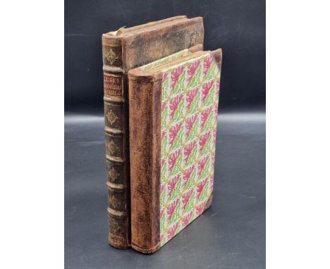
![[CHILDRENS] Sharp, Margery. Miss Bianca, first edition, Collins, London, 1962, boards, dustjacket (price-clipped), illustrat](https://cdn.globalauctionplatform.com/7d6d533a-b4dd-4ae0-8f27-aec500a7849f/07546255-47c6-4be1-83cd-af1e011ea9dd/468x382.jpg)
Lot 365
[CHILDRENS] Sharp, Margery. Miss Bianca, first edition, Collins, London, 1962, boards, dustjacket (price-clipped), illustrations, octavo; together with Sutcliff, Rosemary. Frontier Wolf, first edition, Oxford University Press, Oxford, 1980, boards, dustjacket (non price-clipped), octavo; and Milne, A.A. Winnie-the-Pooh, seventh edition, Methuen, London, 1928, green cloth gilt, dustjacket, top edges gilt, illustrations by Ernest Shepard, octavo, (3). Condition Report : Miss Bianca with ownership inscription to front free endpaper; Pooh with neat owner's name to margin of front free endpaper map. Condition reports are offered as a guide only and we highly recommend inspecting (where possible) any lot to satisfy yourself as to its condition.
![[MAPS] Van den Keere, Pieter (Flemish, 1571-c.1646), 'Anglesey and Carnarvan', engraved map, hand-coloured, 9cm x 12cm; Merc](https://cdn.globalauctionplatform.com/7d6d533a-b4dd-4ae0-8f27-aec500a7849f/bdf4056b-c8bf-4036-8765-af1f00b84d91/468x382.jpg)
Lot 377
[MAPS] Van den Keere, Pieter (Flemish, 1571-c.1646), 'Anglesey and Carnarvan', engraved map, hand-coloured, 9cm x 12cm; Mercator, Gerard (Flemish, 1512-1594), & Hondius, Jodocus (Flemish, 1563-1612), 'Anglesey', engraved map, 15cm x 20.5cm; Bowles, Carrington (British, 1724-1793), The Road from London to Rye, engraved strip map, hand-coloured, 14.5cm x 16cm; together with The Road from London to Portsmouth, engraved strip map, hand-coloured, 14.5cm x 16cm; also Gibson, John (British, fl.1750-d.1792), Hampshire, engraved county map, hand-coloured in outline, 11cm x 6.5cm; and another strip map after a different hand, each framed and glazed, (6).
Lot 321
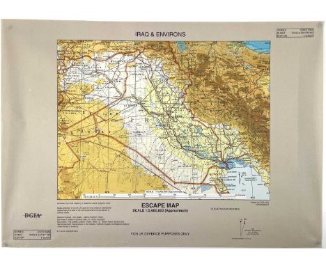
Iraq/Gulf War British Issue Escape Map. A 2002 issue British Escape Map (size 42x30cm) in 1:5,000,000 scale for "UK Defence Purposes Only" printed in simulated micro cloth in full colour. To rear is the legend "I am British, I do not speak your language, I will not harm you" - and also goes on to ask for food and passage and offers a reward for assistance. It is printed in a total of 7 local languages. Unusual item in mint condition in a protective tube.

Lot 643
G.W.R./B.R. Official Publications etc (x14). Comprising 9x G.W.R., 4x British Railways official publications & 1 reprint.G.W.R. "Castles", "Abbeys" & "Cathedrals" - all 1926 hardback editions complete with maps to rear; "Cornish Riviera" both cover styles, "Glorious Devon" both cover styles; "The Glories of the Thames" 1923 and G.W.R. rules book.British Railways: "Holiday Guide S.West" with map to rear 1955; "Holiday Haunts 1960" with map to rear; 2x B.R. Rules Books.Bradshaws reprinted guide for July 1923 some age mottling to pages.
Lot 668
Transport - Railwayana - Railway Carriage Maps & Other Railwayana/Posters etc. Box 1: Comprises 2 framed and glazed railway carriage maps. Map 1: an original by the Southern Railway of the Isle of Wight railway lines. Map 2: "Road to Southern Railway Sunshine " - inscribed Reproduced by courtesy of the British Railways Board.Also included are: a 1975 Isle of Man Steam Railway poster, plus later "The Silver Jubilee", "Child & Engine Driver" and GWR air services poster.Box 2: Various smaller items including a B.R. leather cash bag, a ticket machine, a GWR thief-proof toilet roll holder & GWR handle plus a 1970's era "Golden Hind" named train carriage board.


Lot 606
Albrecht Durer (German, 1471-1528), The Lamentation, Small Passion, (after 1509-1511), Bartsch 43; Meder 152, woodcut, 12.7 by 10cm to margin, together with a folio of prints and maps, to include an 18th Century engraving of Amalthea, maps of Jersey/Guernsey, the Mogul Empire, a 1771 engraving by Joseph Perini, map of Italia Antiqua by N. Sanson, facsimiles etc, (two framed)


Lot 565
Karte des Fürstentums Waldeck (Hessen), Kupferstich/ Bütten, kol., li. o. Wappen Waldecküber Schriftkartusche "Waldeck Comitatus". Re. u. Verlegeradresse: Amsterdami Apud Guiljelmum Blaeu. Bei Blaeu in Amsterdam, ca. 1635. Mittelfalte unten eingerissen, zwei Einrisse re. Rand. Tesastreifenhinterlegung durchgeschlagen. Unterer Plattenrand perforiert. 38,5 x 50,5 cm (Pl), hinter Glas gerahmt. Rahmenmaß 46,5 x 55 cm Map of the county of Waldeck/ Germany, engraving, coloured, published: Blaeu in Amsterdam ca. 1635. Condition lacks. Framed with glass, frame size 46,5 x 55 cm

Lot 566
Karte von Westphalen, ca. 1752Kupferstichkarte, grenz-und flächenkoloriert, li. o. figürlich-allegorische Kartusche mit gestoch. Titel "Circuli Westphaliae in omnes suos Status et Provincias (...)". Bei J. B. Homann in Nürnberg. Aus: Atlas Novus Coelestis. Blattrand und Mittelfalte rücks. umlaufend hinterlegt, Blatt im oberen Bereich braun verfärbt, insgesamt gebräunt mit Lichtrand. Blattrand links mehrere Einrisse, teils hinterlegt. 59,5 x 51,5 cm (Bl) Map of Westphalia, copper etching with coloring, edited in Nuremberg ca. 1752. Lacks of condition. 59,5 x 51,5 cm

Lot 562
Karte des Kreises Stormarn in Schleswig-Holstein, Ende 17. Jh.Kupferstichkarte, Kolorit wohl nachträgl., li. u. Knorpelwerkskartusche mit allegorischer Figurendarstellung, gestoch. Titel "Tabula Geographica novissima DUCATUS STORMARIAE in Meridionali parte HOLSATIAE". Bei Gilis Janssonius van Waesberge und Pitt Moses. Re. o. Meilenzeiger mit Putti mit Hilfsmitteln der Landvermessung. Kolorit verbräunt, Blatt stark verbräunt, auf Pappe aufgezogen, Einrisse re. unt. Ecke, li. Blattrand, oberer Blattrand bis in die Darst., 44 x 54 cm (Pl)/ 49,5 x 58,5 cm (Bl) Map of ducal Stormarn/ Schleswig Holstein/ Northern Germany, copper etching, coloured, published by G. Janssonius Waesberge and Pitt Moses, end of 17th ct. Lacks of condition. 49,5 x 58,5 cm
Lot 571
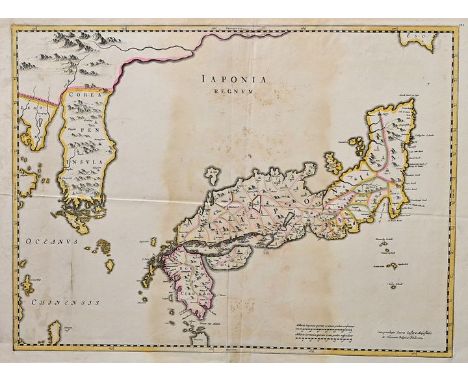
Landkarte Japan"Japonia Regnum". Grenzkolorierte Kupferstichkarte von Joan Blaeu (1596-1673). EA Amsterdam 1655. Unten rechts Meilenzeiger. 45 x 63 cm (Bl). Fleckig verfärbt in Blattmitte und an den Rändern, insgesamt leicht angegilbt. Erstmals in Blaeu's Atlas Sinensis veröffentlicht und als Standart vielfach übernommen. Hier aus einer unbekannten lateinischen Ausgabe. Erste europäische Karte, die Korea als Halbinsel darstellt. Map of The reign of Japan. Coloured copperplate engraving by Joan Blaeu. First edition Amsterdam 1655. Mileage bottom right corner. Stains in center and at the margins, slightly tanned allover. First published in Atlas Sinensis. Here form unknown edition.

Lot 561
Karte von Russland und Schwarzmeerküste, ca. 1720Kupferstich auf Bütten, grenz-und flächenkoloriert, re. o. figürliche Kartusche mit gestoch. Titel "Tablula Geographica qua pars RUSSIAE MAGNAE PONTUS EUXINUS seu MARE NIGRUM et TARTARIA MINOR (...). Bei Joh. B. Homann Nürnberg. Ganzflächig auf Pappe aufgezogen, beide rechte Ecken läd., 59,5 x 49,5 cm (Pl)/ 62 x 51 cm (Bl) Map of Russia and Black sea, copper etching, coloured, stained, mounted on cardboard, published by J. B. Homann Nuremberg ca. 1720.62 x 51 cm
Lot 213
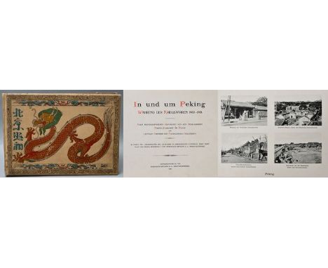
Historisches Album"In und um Peking. Während der Kriegswirren 1900-1901". Wang / Meerscheidt-Hüllessem (Hg.), Berlin (Meisenbach Riffarth & Co.) 1902. Querformatiges Album (Oblong quarto) mit 70 Seiten und originalem Leineneinband mit farbigem Titeldruck eines chinesischen Drachen und kalligraphisch gestalteten chinesischen Schriftzeichen "Fotos von Peking (Beijing)". 36 Tafelbögen, doppelseitig mit einer Heliogravüre sowie 190 Lichtdrucken nach Fotografien bedruckt. Mit ausfaltbarem Plan von Peking, ausführlichst chinesisch bezeichnet. Beigegeben originale Tageszeitung "Shanghai Journal of Commerce" in chinesischer Sprache, August 1923 (13. Jahr der Republik). Faszinierender Bildband mit zahlreichen Aufnahmen von historischen, militärischen und diplomatischen Gebäuden sowie von lokal wirkenden Persönlichkeiten und gesellschaftlichen Szenen aus der unmittelbaren Nachzeit des Boxeraufstandes in Peking 1900/01. Vorangestellt ein Portrait des preußischen Generalfeldmarschalls Alfred von Waldersee (1832-1904), der ab September 1900 als Oberbefehlshaber europäischer Interventionstruppen in Peking eingesetzt war. 24,5 x 34,5 cm (gesamt). Einband berieben und etwas fleckig. Bindung leicht aufgebrochen, einige Seiten lose. Fliegendes Blatt mit Einriß. Buchblock innen in altergemäß gutem Zustand, etwas angegraut und partiell leicht stockfleckig. Karte mit Einriß an Montierung, hier auch Verfärbungen durch Klebefilmrestaurierung. Historic album of Beijing, China, and surroundings directly after the Boxer Rebellion in 1900/01. Published in German language in Berlin 1902. Content of 190 heliogravures after photographs with fold-out map of the City of Beijing with chinese descriptions. Comes with a copy of the Shanghai Journal of Commerce from August 1923. Age-appropriate condition: cover rubbed and with smaller scratches, some stains, binding partially loosened, some pages loose. First page with tear. Pages in good condition, some foxing, tanned at the margins, dusty. Map with tear and colouring over tape fixation.

Lot 559
Konvolut von zwei historischen Karten.a) Karte der Provinz Touraine (Frankreich), Kupferstich, koloriert, re. o. ornamentale Kartusche mit gestoch. Titel "Ducatus Turonensis Perlustratus (...) Isaaco Franco", li. u. Dastellung einer weibl. Figur mit Füllhorn auf Maßstab. Aus: Blaeu, Atlas, ca. 1640, verso latein. Text. Altersgemäß gebräunt mit heller Mittelfalte, Stockflecken, im re. Blattrand hinterlegter Einriss, weiterer Einriss li. Blattrand. Zwei kl. Löcher. Blattrand umlaufend hinterlegt. Rücks. Feuchte-bzw. Schimmelspuren. 46 x 57 cm (Bl); b) Karte/ Faltplan der Umgebung von Berlin, Kupferstich/Stahlstich von Carl Ludwig von Oesfeld 1786, gestochen v. L. Schmidt Berlin. Faltspuren horizontal und vertikal, gebräunt, im Pp. mit Rückkarton. 37 x 46,5 cm (PA), PP. 47,5 x 56,5 cm. Two historic maps: district Touraine in France, from: Blaeu, Atlas, ca. 1640, and: map of the surroundings of Berlin, 1786.

Lot 564
Karte des Herzogtums Braunschweig, 1. H. 18. Jh.Kupferstichkarte mit Grenz-und Flächenkolorit, figürl. allegorische Kartusche unten links, gestoch. Titel "Ducatus Brunsuicensis in tres suos Principatus (...). Verlag J. B. Homann Nürnberg. Blattränder, besonders oben, ausgefranst, Mittelfalte oben eingerissen, Ecken fest auf Unterlage mont., Ecken fingerspurig, partiell Knitterfalten, 51 x 59 cm (Einfassungslinie)/ 52,5 x 60 cm (Bl) (Homann, J. B.:) map of ducal Braunschweig, copper etching, coloured, 1st half of 18th ct., lacks of condition. 52,5 x 60 cm

Lot 570
Kupferkarte Italien"Novissima et accuratissima totius Italiae Corsicae et Sardiniae descriptio" (Italien mit Korsika und Sizilien). Grenz- und flächenkolorierte Kupferstichkarte nach Fredrick de Wit (wohl um 1708). Publiziert bei Renier und Josua Ottens in Amsterdam, um 1740. Oben rechts figürliche Titelkartusche, unten links Meilenzeiger. Mittelbugfalz. 53 x 62 cm (Bl). Angestaubt und randgebräunt. Eselsohren. Map of Italy with Corsica and Sardinia. Coloured copperplate engraving after F. de Wit (pres. around 1708). Published at R&I Ottens, Amsterdam, around 1740. With title cartridge top right, mileage bottom left corner. Centerfold. Dusty and tanned at the margins. Dog ears.

Lot 560
Karte der Peloponnes-Halbinsel, ca. 1700-1730Kupferstichkarte, teilkoloriert, gestoch. Titel REGNUM MORAE accuratissie divisum in PROVINCIAS SACCANIAM, TZACONIAM, CALISCOPIUM et DUCATUM CLARENSAE; una cum INSULIS CAPHALONIA, ZACYNTHO, CYTHERA, AEGINA et SIDRA (...). bei Gerard & Leonard Valk (Valck), Amsterdam. Ganzflächig auf Pappe aufgezogen, gebräunt mit Stockflecken bei heller Mittelfalte, diese unten eingerissen. Unterer Blattrand und Ecken Feuchteschaden. 49,5 x 60,5 cm (Pl)/ 51,5 x 63 cm (Bl) Map of the pensinsula Peloponnes, copper etching, coloured, published by G. & L. Valk (Valck), Amsterdam, 1700-1730. Lacks of condition. 51,5 x 63 cm

Lot 563
Karte westliches Zentralafrika, um 1760Kupferstichkarte, grenz-und flächenkoloriert, von Jacques Nicolas Bellin. Titelkartusche im Rocaillenrahmen links: "Carte des Royaumes de Congo, Angola, et Benguela. Avec les Pays Voisins.". Gebräunt, Faltspur(en), 25 x 32 cm (BA), hinter Glas gerahmt. Ra. 37,5 x 44 cm Map of Central Africa, ca. 1760, copper etching, coloured, by Jacques Nicolas Bellin. Framed with glass and passepartout. Frame: 37,5 x 44 cm


Lot 114
NONESUCH PRESS: 'The Writings of Gilbert White of Selborne, selected and edited by H J Massingham with wood-engravings by Eric Ravilious...': b&w letterpress vignettes, folding map, Vol.1 with ms. gift inscription to front free endpaper, publishers grey cloth gilt, teg, remainder untrimmed, spines faded, 2 vols, large 8vo. Limited Edition No. 408/850 copies. (2)

Lot 14
NONESUCH PRESS: 'The Writings of Gilbert White of Selborne, selected and edited by H J Massingham with wood-engravings by Eric Ravilious...': b&w letterpress vignettes, folding map, Vol.1 with ms. gift inscription to front free endpaper, publishers grey cloth gilt, teg, remainder untrimmed, spines faded, 2 vols, large 8vo. Limited Edition No.414/850 copies. (2)


Lot 25
COKER (John): 'A Survey of Dorsetshire. Containing the Antiquities and Natural History of that County. With a particular description of all the places of note, and antient seats...and a copious genealogical account of 300 of the principal families...' London, printed for J Wilcox, 1732. Folding engraved county map engraved by Seale, 6 engraved plates of armorials, contemporary full speckled calf, a little rubbed at spine foot and corners, else a fine copy, folio. (1)
Lot 49
HASSELQUIST (Frederick): 'Voyages and Travels in the Levant; in the years 1749, 50, 51, 52..', London, printed for L Davis and C Reymers, 1766: FIRST ENGLISH EDITION. With half title and folding frontispiece map: contemporary gilt ruled calf boards, recently rebacked, moderate toning and light spotting, 8vo. (1)
Lot 51
ANNOTATED BY PETER COLLINSON, FRS (1694-1768): MARTIN (Martin): 'A Description of the Western Islands of Scotland. Containing a full account of their situation, extent, soils, product, harbours, bays, tides, anchoring places, and fisheries...': London, printed for Andrew Bell, 1703: FIRST EDITION. Large folding map of the Hebrides (neatly repaired) and folding plate of heathen temple: this copy extensively annotated by naturalist and antiquary Peter Collinson (1694-1768) over some 90 pages, with 5 pages of manuscript index and additional notes at end. He relates, for instance, the experience of General Wade, who saw an eagle kill a deer by picking out its eyes and then hovering until the deer stumbled over a precipice. He also includes information given him by Dr Walker, who visited the islands in 1765, and who conveyed to Collinson his scepticism of the reputed second sight of some islanders as well as reporting that there were 'neither wild horses or buffaloes in Scotland as Mr Buffons asserts in his nat:hist: taken from ignorant writers': title leaf cropped at upper margin, some toning and scattered spotting, occasional light waterstains but a very good copy, later full calf gilt by Kerr & Richardson of Glasgow, teg, 8vo. (1)
Lot 23
MORTON (John): 'The Natural History of Northampton-shire; with some account of the antiquities..', London, R Knaplock, 1712: folding map engraved by John Harris, engraved plates by La Vergne, contemporary gilt ruled calf, recently rebacked: together with GOUGH (Richard): 'British Topography. Or an historical account of what has been done for illustrating the topographical antiquities of Great Britain and Ireland..' London, 1780: 2 vols, FIRST EDITION, engraved title vignettes, 7 folding engraved maps and large map in 2 parts. (3)
Lot 26
LEIGH (Charles): 'The Natural History of Lancashire, Cheshire, and the Peak, in Derbyshire: with an account of the British, Phoenician, Armenian, Gr. and Rom. Antiquities in those parts...' Oxford, printed for the author, 1700: engraved portrait frontispiece, double page engraved map by Herman Moll with contemporary outline and colouring and twenty-four engraved plates, period panelled calf with spine gilt, recased preserving the backstrip, some thin partial cracking to hinges but firm, repaired closed tear to inner edge of title leaf, generally a good crisp copy, folio. Together with a defective copy of Richard Blome's 'Britannia', 1673, lacking maps. (2)
Lot 48
KALM (Peter): 'Travels into North America; containing its natural history, and a circumstantial account of its plantations and agriculture in general..', London, printed for T Lowndes, 1772: 2nd edition. 2 vols, folding engraved map and 6 engraved plates, folding map with some careless creasing, a few stains and repairs, occasional light spotting and marks, bookplates of Earl of Roden, contemporary sheep boards, rebacked and corners renewed, 8vo. (2)
Lot 41
WESTON (Richard): 'The Universal Botanist and Nurseryman: containing descriptions of the species and varieties of all the trees, shrubs, herbs, flowers, and fruits, natives and exotics...', London, printed for J Bell, 1770-77. 4 vols, engraved plates, contemporary tree calf, rubbed and scuffed. Uniformly bound with: 'The English Flora: or, a catalogue of trees, shrubs, plants and fruits, natives as well as exotics...also, a general catalogue of seeds, for the kitchen-garden, flower-garden, grass-lands &c...', London, printed for the author, 1775: GILPIN (William): 'Remarks on Forest Scenery, and other woodland views, (relative chiefly to picturesque beauty), illustrated by the scenes of New-Forest in Hampshire..', London, printed for R Blamire, 1791: FIRST EDITION, 31 plates and one double-page map, contemporary red half morocco gilt, rubbed: plus one other. (8)

Lot 113
LEGGE (William Vincent): 'A History of the Birds of Ceylon...' London, published by the author, 1880: with coloured map, one uncoloured plate and 34 hand-coloured plates by Keulemans: preliminary and final quire frayed/loose and with crude tape repairs, a few other leaves pulling or with small repairs to edges, contemporary plum half calf gilt, rubbed with inner joints split, for sale with all faults: with 5 others flora/fauna of Ceylon, to include Woodhouse & Henry's 'The Butterfly Fauna of Ceylon', Colombo 1942: Le Messurier's 'Game Shore and Water Birds of India' 4th edition 1904, and a bundle of plates from Trimen's 'Flora of Ceylon', 1894. (6)
Lot 24
PLOT (Robert): 'The Natural History of Oxford-shire, being an essay towards the natural history of England...' Oxford, printed by Leon. Lichfield, for Charles Brome and John Nicholson, 1705: 2nd edition. Folding engraved map of the county (laid down on linen), 16 engraved plates, publishers adverts to verso of final leaf, contemporary blind ruled calf neatly rebacked to match, a little rubbed to extremities, a very good copy, folio. Together with a copy of the first edition of 1677, with the folding map in facsimile. (2)
Lot 108
ANTIQUARIAN: ENGELMANN (Dr C): 'Kreuznach, ses sources minerales et leur mode d'administration..' Heidelberg, Jos. Engelmann, 1839: with lithographic frontispiece, 2 plates and folding map: contemporary diced calf boards, gilt ruled, recently rebacked to match, 8vo: with 7 others, continental antiquarian, 17th-19thc, to include a 464 page 18th century Dutch devotional manuscript. (8)
Lot 46
PONTOPPIDAN (Erich, Right Rev.): 'The Natural History of Norway: containing a particular and accurate account of the temperature of the air, the different soils, waters, vegetables, metals, minerals, stones, beasts, birds, and fishes...', London, printed for A Linde, 1755. FIRST EDITION in English, 2 parts in one vol, woodcut initials and decorations, folding engraved map hand-coloured in outline and 28 plates, scattered light foxing and marks, recent panelled calf in period style, folio. (1)

Lot 239
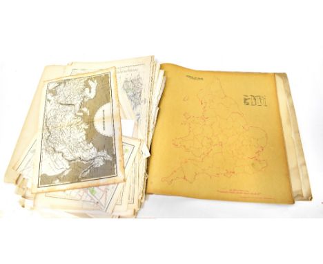
INDIA: 'Map of the Jute-Growing Districts...specially published for the European Jute Dealers Association...': colour litho map printed on paper and laid onto linen, folding into 48 sections within original cloth covered boards, some wear and soiling, circa 1900: with a small quantity of other maps, photographs and ephemera. (Small tray)

Lot 30
LAKE DISTRICT: WEST (Thomas): 'A Guide to the Lakes, in Cumberland, Westmoreland, and Lancashire..', London, printed for Richardson and Urqhart, 1780: 2nd edition. 19th century green half morocco, spine gilt lettered, old blue ink ownership to lower margin of pp81, some scattered foxing and offsetting else a very good copy, 8vo. Together with 'A Complete Guide to the Lakes, comprising minute directions for the tourist, with Mr Wordsworth's description of the scenery of the county, &c..' Kendall, Hudson & Nicholson, 1842: publishers blind stamped blue cloth gilt, minor wear else VG: OTLEY (Jonathan) 'A Concise Description of the English Lakes. The Mountains in their vicinity, and the roads by which they may be visited..', Keswick, published for the author, 1823: folding map frontispiece, waterstaining round end leaves, period half calf over marbled boards, rebacked, 12mo. (3)
Lot 27
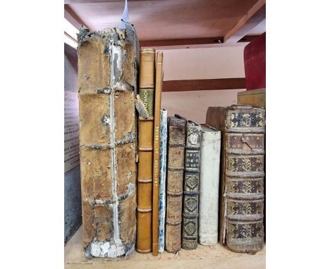
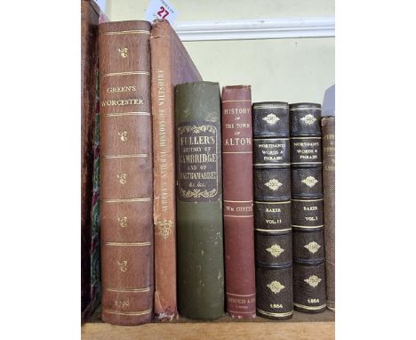
GREEN (Valentine): 'The History and Antiquities of the City and Suburbs of Worcester..': London, printed for the author, 1796: 2 vols in 1, engraved titles, portrait, folding map and numerous plates, later plum calf, spine gilt ruled and lettered, 4to: with 5 other vols, 19th century British topography, including Williams Curtis's 'History and Description of the Town of Alton', Winchester 1896. (6)

Lot 50
HEATH (Robert): 'A Natural and Historical Account of the Islands of Scilly...': London, printed for R Manby, 1750. With folding map, table and plate of Upnor Castle, without final advertisement leaf, contemporary gilt ruled calf boards, recently rebacked, some toning and foxing but a good copy, Wotton bookplate overlaid with that of John Waldie, 8vo. (1)

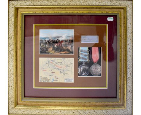
Lot 745
CHARGE OF THE LIGHT BRIGADE; a framed montage comprising a small section of map titled 'Battle of Balaclava 25th October 1854', a colour print of the battle, a photograph of two medals and a slip of paper bearing the signature of Lord Cardigan, 25 x 30cm, framed and glazed, with certificate of authenticity issued by Autograph Collection 'Member of the Universal Autograph Collectors Club' attached verso.
Lot 1040
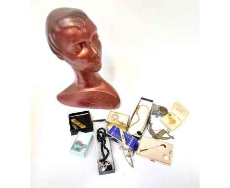
A quantity of vintage and contemporary costume jewellery to include a Chanel-style pendant, metal bangle set with small white stones, an Art Deco style red beaded necklace, various brooches to include Art Deco style examples, animal examples, various vintage compacts to include a golfing-style example, an example in the form of a camera with legs of man, a white metal compact with cut-out map of India, etc and a hat display mannequin.

Lot 508B
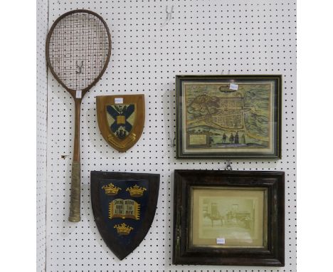
An Edinburgh University coat of arms wall plaque, together with another similar heraldic wall plaque, a framed sepia photograph of Morningside Road, framed reproduction of Braun's 1582 map of Edinburgh, a vintage badminton racquet, an EPNS beaker engraved "2000" and a cutlery canteen containing knives only (7) Condition Report:Available upon request


Lot 183
After Emanuel Bowen. An accurate map of Nottinghamshire, describing it's Wapontakes and divisions, hand coloured engraving, To the Most Noble Thomas Duke of Newcastle, 72cm x 57cm, together with a copy of a map of the county of Nottingham, after a survey by C and J Greenwood, 39cm x 49cm. (2)


-
109198 item(s)/page