We found 109182 price guide item(s) matching your search
There are 109182 lots that match your search criteria. Subscribe now to get instant access to the full price guide service.
Click here to subscribe- List
- Grid
-
109182 item(s)/page


Lot 105
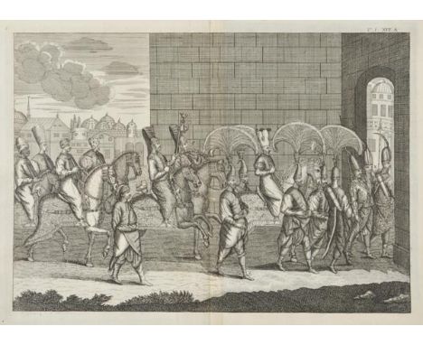
Ramble (Reuben). Reuben Ramble's Travels through the Counties of England, circa 1850, decorative frontispiece and additional decorative title, forty (complete) engraved maps surrounded by lithographic vignettes with contemporary hand colouring, each map with page of descriptive text, near contemporary ownership signature to front blank, later endpapers, contemporary red cloth with gilt title to upper siding, rebacked but retaining the majority of the original spine, a little worn and stained, 8vo Uncommon. Chubb. DXVII. (1)
Lot 109
Rowlands (Henry). Mona Antiqua Restaurata. An Archaeological Discourse on the Antiquities, Natural and Historical, of the Isle of Anglesey, the Antient Seat of the British Druids..., with an Appendix, containing a comparative table of primitive words, 2nd edition, Corrected and Improved, printed for J. Knox, 1766, engraved frontispiece map and 12 engraved plates, occasional old ink annotations, errata leaf at end, with bookseller's advertisement to verso, contemporary full calf, rubbed, joints slightly cracked at head, 4to Ex libris Paul Panton, with his bookplate to front pastedown, and manuscript bibliographical note regarding the work with his signature to front endpaper. (1)
Lot 110
Rutter (John). Delineations of the North Western Division of the County of Somerset, and of its Antediluvian Bone Caverns, with a Geological Sketch of the District, 1829, engraved and lithograph plates, folding hand-coloured map, some spotting, recent printed marbled endpapers, contemporary calf, gilt decoration borders to boards, modern reback with gilt decorated spine, 8vo, together with Healey (Charles E.H. Chadwyck), The History of the Part of West Somerset, Comprising the Parishes of Luccombe, Selworthy, Stoke Pero, Porlock, Culbone and Oare, pub. Sotheran, 1901, portrait frontispiece, coloured folding map, illustrations, unopened, original buckram, a few marks, 4to, (limited edition, 42/60 large paper copy), with Waylen (James), Chronicles of the Devizes..., 1839, lithograph frontispiece and few plates, some spotting, modern cloth, 8vo, and Moffatt (J.M.), The History of the Town of Malmesbury, pub. Tetbury, 1805, engraved frontispiece, two plates and one plan, occasional spotting, modern cloth, 8vo, plus one other (5)

Lot 111
Senex (John). The Roads through England delineated or Ogilby's Survey Revised, Improved and Reduced to a Size Portable for the Pocket..., published John Bowles and Son, 1759, calligraphic title page, four pages of text and tables, general map of England & Wales, 101 (complete) uncoloured engraved strip road maps printed back-to-back, contemporary endpapers but lacking covers, oblong 8vo (1)

Lot 112
Senex (John). The Roads through England delineated or Ogilby's Survey Revised, Improved and Reduced to a Size Portable for the Pocket..., published John Bowles and Son, 1759, calligraphic title page, four pages of text and tables, general map of England & Wales, 101 (complete) uncoloured engraved strip road maps printed back-to-back, book plate of R.H. Johnstone, modern endpapers, modern cloth, oblong 8vo, together with, Paterson (Capt. Daniel), Paterson's Itinerary Being a New and Accurate Delineation and Description of the Direct and Principal Roads of Great Britain..., volume 1 (only of two), published Carington Bowles, 1785, double page engraved map of England & Wales with contemporary hand colouring, calligraphic title page, dedication, preface and tables, 186 uncoloured engraved strip road maps on forty-seven sheets printed back-to-back, index bound at rear, book plate of Cornelius Heathcote Rodes, contemporary calf, rubbed and worn, 8vo (2)

Lot 113
Shaw (Rev. Stebbing). The History and Antiquities of Staffordshire, Compiled from the Manuscripts of Huntbach, Loxdale, Bishop Lyttelton and other Collections of Dr. Wilkes, The Rev. T. Feilde &c. &c....., 2 vols., [volume 1 and volume 2 part 1 (all published)], 1798-1801, ownership signature of John Minors to upper blank margin of vol. 1 title (listed as Minors esq. of Eccleshall in subscribers list), folding engraved county map (with short closed tear), eighty-two engraved and aquatint plates (one folding), folding engraved plan of the town of Wolverhampton, engraved illustrations to text, occasional toning & spotting to text leaves, edges untrimmed, 20th century green half morocco by Riviere & Son, gilt decorated spines, lightly faded to spines, folio Upcott pp.1176-1185. Large Paper copy. (2)

Lot 116
Speed (John). The Second Booke: Containing the Principality of Wales: Delivering an exact Topography of the Following Counties. Pembroke-Shire, Caermarden-Shire, Glamorgan-Shire, Brecknock-Shire, Radnor-Shire, Cardigan-Shire, Mountgomery-Shire, Merioneth-Shire, Denbighshire, Flint-Shire, Caernarvon-Shire, Anglesey Isle. With the Divisions of their Cantreves and Commots. Descriptions of their Cities and Shire-Townes..., printed M. and S. Simmons for Roger Rea, 1662, letterpress title, general map of Wales and twelve (complete as list) uncoloured engraved double page county maps by John Speed, all with English text on verso, a few maps with margins strengthened on verso, occasional marginal repaired closed tears, slight creasing, the maps have been re-guarded and this has caused some browning to the central fold, front blank torn with loss and repaired, later marbled endpapers, 19th century gilt calf, skillfully re-backed, slim folio (1)

Lot 119
Warner (Rev. Richard). The History of Bath, 1st edition, published by R.Cruttwell, Bath, and G & J Robinson, London, 1801, frontispiece of an engraved colour portrait, folding engraved map of Bath, extra-illustrated with numerous engravings and prints, near contemporary pig skin with gilt decorated corners and turn-ins, skillfully rebacked with gilt decorated spine by the Doves Bindery, a little worn at extremities, 4to (1)
Lot 121
Warrington (Rev. William). The History of Wales, in Nine Books: With an Appendix, 1st ed., 1786, scattered spotting, previous owner signature, contemporary tree calf, rebacked and repaired (spine faded), 4to, together with A Historical Tour through Pembrokeshire, by Richard Fenton, 1811, title with engraved vignette, engraved portrait, folding map, 29 engraved plates only (lacking plate 18, St. Govan's Chapel), a few tears, some spotting and toning, later morocco, some fading, with two others: The Description of Penbrokshire, by George Owen of Henllys, Lord of Kemes, 3 volumes, 1892-1906 and H. Thornhill-Timmins' Nooks and Corners of Pembrokeshire, 1895 (upper cover with dampstains) (6)
Lot 125
[Worsley, Richard]. The History of the Isle of Wight, 1781, engraved vignette to title, folding engraved map hand-coloured in outline, 31 engraved plates (including 12 double-page), few vignette illustrations, some spotting, browning and offsetting, later endpapers with upper hinge splitting, near contemporary calf, neatly rebacked with gilt decorated spine, upper joint splitting, rubbed and board corners worn, 4to (1)
Lot 14
Forester (Thomas). Rambles in the Island of Corsica and Sardinia, with Notices of their History, Antiquities, and Present Condition, 2nd edition, 1861, hand coloured map and eight coloured or tinted lithograph plates (including one folding), few wood engraved illustrations to text, bookplate to front pastedown, original publisher's green cloth, rubbed and scuffed, large 8vo (1)
Lot 162
Sowerby Family. A group of books and manuscripts written by or to James and William Sowerby, 1800's-1900's, comprising: Mawe (John), Instructions for the Management of the Blow-Pipe, Chemical Tests, &c. Intended to Accompany Familiar Lessons on Mineralogy, Arranged to Assist the Learner, 1st edition, 1820, half title, hand-coloured engraved frontispiece, a few light spots, bookplate of William Sowerby, contemporary morocco-backed boards, spine vertically split, with upper cover detached, rubbed, 12mo, together with Lyell (Charles), Principles of Geology, Being an Attempt to Explain the Former Changes of the Earth's Surface, volume I only (of three), 2nd edition, 1832, engraved frontispiece, two engraved maps, one folding, publisher's catalogue at front, light offsetting and a few spots, bookplate of William Sowerby, original boards, spine split, text block in two halves, some wear to spine, 8vo, plus Salter (J.W.) & Henry Woodward, A Descriptive Catalogue of all the Genera and Species Contained in the Accompanying Chart of Fossil Crustacea, Showing the Range in Time of the Several Orders; with some Recent Types, illustrated by Upwards of Four Hundred and Ninety Figures, [1865], 16 steel-engraved linen-backed sections by J.W. Lowry (light uniform toning), 885 x 685mm (34.75 x 27ins), text inscribed in pencil at head of title: "J.W. Salter to J. Dibel(?), Aug 9th 1867", plus Smith (James Edward), Compendium Florae Britannicae, 1816, scattered spotting and light toning, publisher's catalogue at front, bookplate of William Sowerby, original boards, some splits and chips to spine, 8vo, inscribed to front endpaper: "Mr Sowerby, from his sincere friend the author", additionally inscribed to half title "Sowerby's Museum", with other manuscript letters, documents, books and related items including printed vellum documents from the City of London, awarding the freedom of the City of London to James De Carle Sowerby (1814), Wiliam Sowerby (1899), Edward Scargill (1812), Edward Scargill Junior (1848) and Thomas William Scargill (1900), a printed French visa for a passage from London to Dieppe for James Sowerby, 1820, a manuscript map charting the course of the 'Countess of Elgin', London to Australia, 1852-53, inscribed to James Edward Byrant from the author (A.J. Jolly), six manuscript letters from Prince Francis of Teck to William Sowerby, 1875-90 [Teck, president of the Royal Botanic Society to Sowerby, secretary of the same], other stamped envelopes addressed to J.B. & J.J. Sowerby, unused postcards and stationery etc Perhaps the greatest collective contribution of James de Carle Sowerby (1787-1871) and William Sowerby (1827-1906) to the Victorian scientific scene was the establishment of the Royal Botanic Gardens and Society, in the administration of which the family were heavily involved until the 20th century, best represented here with a series of letters from the Society's honorary president, Francis of Teck. Several of the books in this group bear the bookplate of William Sowerby and one bears the inscription of 'Sowerby's Museum'. The larger portion of the Sowerby family archive remained in family ownership until the 1960s, when the death of William Sowerby's grandson James Frank Sowerby (1887-1968), precipitated its dispersal into the book trade and at auction, much of it acquired by the Natural History Museum (reference I. MSS Sowerby Coll). (small carton)
Lot 17
HMS Challenger. A Diary of the Wreck of His Majesty's Ship Challenger, on the Western Coast of South America in May, 1835. With an Account of the Subsequent Encampment of the Officers and Crew, During a Period of Seven Weeks on the South Coast of Chili, 1st ed., 1836, two folding lithographed plates (one with closed tear), folding map, plan, some light soiling, publisher's list at front, contemporary cloth, some fading and stains, spine chipped, 8vo (Sabin 19961), together with Drew (Frederic), The Northern Barrier of India. A Popular Account of the Jummoo and Kashmir Territories, 1st ed., 1877, three Woodbury-type photographic illustrations (two detached), folding colour map (one fold with clear tape repair), folding view, publisher's list at end, light toning front and rear, endpapers renewed, original cloth, spine faded with tears, 8vo (2)


Lot 174
Bedfordshire. Speed (John), Bedford Shire and the Situation of Bedford described with the armes of thos Honorable Familyes that have borne ye titles of Dukes and Earls thereof, published Thomas Bassett & Richard Chiswell, [1676], uncoloured engraved map, inset town plan of Bedford, marginal repaired closed tears, 385 x 510 mm, English text on verso, together with, another example similar, published in 1616, with hand colouring and marginal staining and fraying, 390 x 515 mm, Latin text on verso, with, Greenwood (C & J), Map of the County of Bedford from an Actual Survey made in the Year 1825..., engraved map with contemporary hand colouring, uncoloured engraved vignette of Woburn Abbey, slight staining and offsetting, 575 x 680 mm, with another eighteen maps of Bedfordshire including examples by Dawson, Morden, Greenwood, Cole & Roper, Harrison, Cary and Smith, some duplicates, various sizes and condition (21)
Lot 175
Birmingham. Sherriff (James), A Map of Upwards of 25 Miles round the Town of Birmingham..., published Jas. Sherriff & Wm. Faden, 1798, large engraved map with contemporary outline colouring, sectionalised and laid on linen, decorative uncoloured cartouche and mileage scale, table of explanation and compass rose, slight spotting, 845 x 705 mm Uncommon. (1)
Lot 177
Brecknockshire. Speed (John), Breknoke both Shyre and Towne described, published Thomas Bassett & Richard Chiswell, [1676], hand coloured engraved map, inset town plan of Brecknock, long closed tear affecting image, central fold strengthened on verso, 390 x 510 mm, blank on verso, together with, Flint - Shire, published John Sudbury and George Humble, circa 1627, uncoloured engraved map, inset town plans of St. Asaph and Flint, 390 x 515 mm, English text on verso, with, Blaeu (Johannes), Radnoria Comitatus Radnor Shire, published Amsterdam circa 1645, engraved map with contemporary hand colouring, slight staining, 385 x 500 mm, French text on verso, with another eleven maps of Welsh counties and regions, including examples by Saxton/Kip, Morden, Cary and Bowen, some duplicates, various sizes and condition (14)
Lot 178
British Isles. Sanson (Nicolas), Carte Generale des Royaume D'Angleterre, Escosse et Irlande avecq les Isles Circonvoysines Conues toutes sous le nom de Britanniques..., published Paris, Pierre Mariette, circa 1650, engraved map with contemporary outline colouring, inset map of the Isles of Shetland, small repairs to lower margin corners, not affecting image, 410 x 540 mm, mounted, together with, Neele (Samuel), North America, published Cadell & Davies, 1812, engraved map with contemporary outline colouring, 510 x 710 mm, mounted, with another forty-five celestial and terrestrial maps and views, including examples by Neele, Bonne, Monin, Cary and Bellin, various sizes and condition (approx.45)
Lot 181
Durham. Blaeu (Johannes), Episcopatus Dunelmensis vulgo The Bishoprike of Durham, published Amsterdam, circa 1645, engraved map with contemporary hand colouring, 385 x 500 mm, French text on verso, together with, Jansson (Jan), Episcopatus Dunelmensis vulgo The Bishoprike of Durham, published Amsterdam, circa 1650, engraved map with contemporary hand colouring, ornate cartouche, compass rose and numerous rhumb lines, slight overall toning, 405 x 510 mm, French text on verso, with another copy framed and glazed, plus another twenty-three county maps and town plans including examples by Blome, Saxton/Kip, Morden, Pigot, Cary, Duncan, Dawson, Lewis, Fullarton, Hinton, Bowen and Kitchin, some duplicates, various sizes and condition (26)
Lot 182
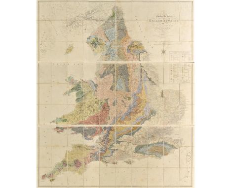
England & Wales. Greenough ( G.B.), A Geological Map of England & Wales by G.B.Greenough, President of the Geological Society..., 1819 [but published 1820], engraved map with contemporary hand colouring, on three sheets, sectionalised and laid on linen, compass rose and table of explanation, some staining, each sheet approximately 640 x 1620 mm, contained in a marbled book box, worn A map which was controversial at the time of its publication in that Greenough was accused of plagiarising William Smith's earlier and ground breaking geological survey and map of 1815. Greenough was stung enough by the critisicm to issue a written defense of his actions which was published in 'Memoir of a Geological Map of England: to Which are Added, an Alphabetical Index to the Hills, and a List of the Hills Arranged According to Counties (1820), p4.'.Smith's low social staus and background resulted in his work being largely ignored and the Geological Society of London did indeed plagiarise the map, undercutting Smith's asking price, which eventually pushed Smith to financial ruin and the debtor's prison. Recognition of his role as 'The Father of English Geology' would only follow much later in 1831 when Smith was awarded the Woolaston medal by the Geological Society. Greenough's map is important in its own right and is now recognised as a separate piece of scholarship but unlike Smith it involved no surveying but relied on other surveyors sending him information which he then collated. (1)

Lot 183
England & Wales. (Walker J & C), A Geological Map of England, Wales and Part of Scotland, Showing also the Inland Navigation by Means of Rivers & Canals, with their Elevation in feet above the Sea, together with the Rail Roads & Principal Roads, circa 1838, engraved map sectionalised and laid on linen, original hand colouring, calligraphic title, table of explanation, geological and mineralogical cross section below map, 1420 x 990mm, contained in a contemporary cloth book box with contrasting gilt morocco label to spine, box a little faded and stained (1)
Lot 184
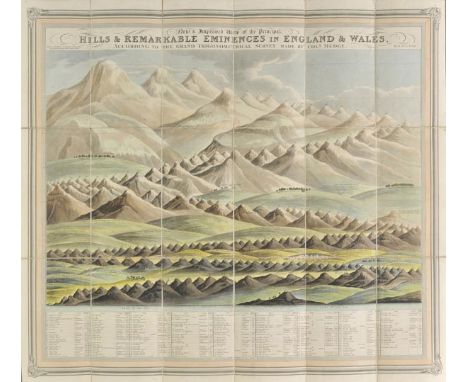
England & Wales. Butt (Revd. J.M. Butt), New & Improved View of the Principal Hills & Remarkable Eminences in England & Wales, According to the Grand Trigonometrical Survey made by Coln. Mudge, published William Darton, 1825, aquatint comparison sheet with contemporary hand colouring, sectionalised and laid on linen, 590 x 665 mm, marbled endpapers, contained in contemporary marbled card slipcase with manuscript label to upper cover, together with, Cary (John), Cary's Reduction of his six sheet Map of the British Isles Comprehending the whole of the Turnpike Roads, with the Great Rivers and the Course of the different Navigable Canals..., 1824, engraved map with contemporary outline colouring, sectionalised and laid on linen, inset map of the Shetland Islands, some spotting and slight toning, 1240 x 960 mm, contained in contemporary card slip case with printed label to upper cover, with, Cruchley (George F.), Cruchley's Improved Geographical Companion throughout England & Wales Including part of Scotland, 1838, engraved map with contemporary outline colouring, sectionalised and laid on linen, 970 x 660 mm, contained in contemporary cloth slipcase with printed label to upper cover, plus, Walker (J & C), England & Wales founded upon the Grand Trigonometrical Survey shewing all the Railways, the Rivers & Navigable Canals..., circa 1840, engraved map with contemporary outline colouring, sectionalised and laid on linen, 1310 x 1030 mm, contained in later marbled card slipcase, and, Phillips (M.), 2nd. Edition of The Grand Southern Tour of England including a Principal part of the East, West and Inland Counties, Patronised by His most Gracious Majesty King George the IV..., published Jon. Hebner, 1821, large engraved map with contemporary outline colouring, sectionalised and laid on linen, 1020 x 1825 mm, marbled endpapers, contained in contemporary marbled card slipcase, with another four folding maps similar, including examples by Stanford, Kitchin, Cruchley and Letts, various sizes and condition (9)
Lot 185
Essex. Greenwood (C & J), Map of the County of Essex from an Actual Survey made in the Year 1824..., published Greenwood & Pringle & Co., [1825], large uncoloured engraved map on six conjoined sheets, calligraphic cartouche, engraved vignette of Audley End House, table of explanation and compass rose, occasional marginal closed tears, one split along old fold, folds strengthened on verso, old adhesion stains on verso, 1275 x 1520 mm (1)
![*Greece. Speed (John), Greece, published Thomas Bassett & Richard Chiswell, [1676], hand coloured engraved map, ornate strapw](https://cdn.globalauctionplatform.com/a21f5fd7-def9-4b2a-95ed-a5f700d54520/812e83aa-3eb7-4a89-dc47-0a836abe8897/468x382.jpg)
![Italy. Ortelius (Abraham), Thusciae Descriptio Auctore Hieronymo Bellarmato, [1588], uncoloured engraved map of Tuscany, orna](https://cdn.globalauctionplatform.com/a21f5fd7-def9-4b2a-95ed-a5f700d54520/59758b37-9b6d-4c36-edd2-d9a965d3eff9/468x382.jpg)
Lot 192
Italy. Ortelius (Abraham), Thusciae Descriptio Auctore Hieronymo Bellarmato, [1588], uncoloured engraved map of Tuscany, ornate strapwork cartouche, slight staining and spotting, largely confined to margins, 315 x 490 mm, Spanish text on verso Marcel van den Broecke, Ortelius Atlas Maps, no.130. (1)
![Italy. Ortelius (Abraham), Tusciae Antiquae Typus..., [1595], uncoloured engraved map, three decorative strapwork cartouches,](https://cdn.globalauctionplatform.com/a21f5fd7-def9-4b2a-95ed-a5f700d54520/44bd1887-5b33-4e96-a059-25faba4827c1/468x382.jpg)
Lot 196
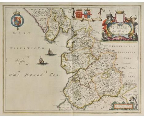
Lancashire. Blaeu (Johannes), Lancastria Palatinatus Anglis Lancaster et Lancas Shire, published Amsterdam, circa 1645, engraved map with contemporary hand colouring, ornate cartouche and mileage scale, 400 x 515 mm, Latin text on verso, together with, Jansson (Jan), Lancastria Palatinatus Anglis Lancaster & Lancasshire, published Amsterdam, circa 1655, engraved map with sparse hand colouring, central fold strengthened on verso, slight mount staining, 380 x 505 mm, French text on verso (2)
Lot 198
Leicestershire & Rutland. Blaeu (Johannes), Leicestrensis Comitatus Leicester Shire [and] Rutlandia Comitatus Rutland Shire, published Amsterdam, circa 1672, two engraved maps with contemporary hand colouring, slight spotting to the map of Leicestershire, each approximately 390 x 500 mm, Spanish text on verso, together with another seventy-eight maps of Leicestershire and Rutland, including examples by Greenwood, Cary, Morden, Cary, Lewis, Kitchin, Harrison, J & C Walker, Smith, Fullarton, Collins, Hall, Moule, Van den Keere and Ramble, several duplicates, various sizes and condition (80)
Lot 20
Knight (E.F.). Madagascar in War Time, the 'Times' Special Correspondent's Experiences among the Hovas during the French Invasion of 1895, Longmans, Green, & Co., 1896, black and white frontispiece, folding map at rear, three further black and white plates, scattered minor spotting, bookplate of Andrew Jameson to upper pastedown, original publisher's gold-coloured cloth, a little dust-soiled to spine, minor wear to extremities, 8vo (1)
Lot 200
Lincolnshire. Jansson (Jan), Lincolnia Comitatus Anglis Lincolne Shire, published Amsterdam, circa 1655, engraved map with contemporary hand colouring, slight overall toning, 400 x 500 mm, Latin text on verso, with another five maps and town plans of Lincolnshire including examples by Morden, Teesdale, Duncan, Stukeley and Cary, various sizes and condition (6)
Lot 201
*London. Flyn (J.), A New and Correct Plan of London, Westminster and Southwark with the New Building to the Year 1770, uncoloured engraved map, old folds, 300 x 510 mm, mounted, framed and glazed, together with, Vue D'optique, The South West Prospect of London, circa 1770, engraved view of London with contemporary hand colouring, title repeated in French, trimmed to image, 235 x 400 mm, mounted, framed and glazed (2)

Lot 207
Middlesex. Speed (John), Midle-Sex described with the most Famous Cities of London and Westminster, published George Humble, circa 1627, uncoloured engraved map, inset town plans of Westminster and London, inset vignettes of St. Peters and St. Pauls, some dust soiling, central fold split and frayed, 390 x 515 mm, English text on verso, later paper wrappers (1)
Lot 208
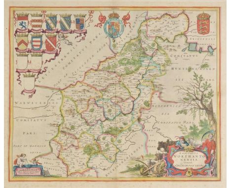
Northamptonshire. Blaeu (Johannes), Comitatus Northantonensis vernacule Northamton Shire, published Amsterdam, circa 1648, hand coloured engraved map, large ornate cartouche and mileage scale, slight spotting, largely confined to margins, 420 x 505 mm, French text on verso, together with, Saxton (Christopher & Kip William), Northamtoniae Comitatus Descriptio in quo Coritani olim Insederunt, [1637], uncoloured engraved map, slight spotting, central fold partially strengthened on verso, 290 x 360 mm, together with another fifty-eight engraved maps of Northamtonshire, including examples by Lewis, Archer, Morden, Kitchin, J & C Walker, Cary, Pigot, Harrison, Duncan, Teesdale, Seller/Grose, Fullarton, Collins, Greenwood and Moule, some duplicates, various sizes and condition (60)
Lot 21
La Mottraye (Aubrey de). Travels through Europe, Asia, and into Part of Africa; with Proper Cutts and Maps. Containing a great variety of geographical, topographical, and political obversations on those parts of the world; especially on Italy, Turky, Greece, Crim and Noghaian Tartaries, Circassia, Sweden, and Lapland, 3 volumes, 1st English edition, printed for the author [3rd volume printed for E. Symon & others], 1723-32, first volume with printed licence leaf facing title, third volume with engraved frontispiece, 56 copper engraved maps and plates, including many folding or double-page, first volume with short wormtrack towards centre of inner margins at rear, slightly affecting some plates, one folding map to second volume torn without loss, third volume with wormtrack to extreme lower outer corners at centre of volume, contents generally in very good, clean condition, contemporary full calf blindstamped calf, gilt decorated spines, rubbed and some wear to edges with joints to first and second volumes, partly cracked, folio (358 x 220 mm) Ex libris Thomas Johnes (1748-1816) of Hafod, with his bookplate to front pastedown of each volume. Atabey 661. Navari 946: 'This important work describes La Mottraye's travels over a 26-year period which took him through Northern Europe to Tartary and the Levant. The plates are of particular interest and include many signed by Hogarth which form part of his early work. They illustrate antiquities, objets d'art, and scenes of the eastern life.' (3)

Lot 212
Pembrokeshire. Speed (John), Penbrokshyre described and the Sittuations both of Penbroke and St. Davids shewed in due form as they were taken..., 1st. edition, published John Sudbury & George Humble, [1611], hand coloured engraved map, inset town plans of Pembroke and St. Davids, 385 x 510 mm, English text on verso A good dark impression. (1)
Lot 213
Pigot & Co (Publishers). Pigot and Co.'s Maps of the Counties of Derby, Hereford, Lincoln, Leicester and Rutland, Monmouth, Nottingham, Salop, Stafford, Warwick and Worcester; with a General Map of Wales, [1828], large folding map of Wales and ten engraved county maps, all with contemporary outline colouring, each map approxmately 375 x 250 mm, publisher's paper wrappers with printed title, contained in later marbled slip case (1)
Lot 214
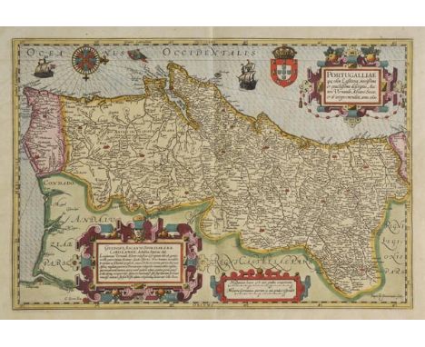
Portugal. Mercator (Gerard & Hondius Jodocus), Portugalliae Que Olim Lusitania, Novissima et Exactissima Descrtiption Auctore Vernando Alvaro Secco..., circa 1610, engraved map by Baptista van Doetecum, with contemporary hand colouring, three ornate strapwork cartouches, compass rose and rhumb lines, slight oxidisation to old watercolour causing slight cracking, repaired on verso, 335 x 495 mm, German text on verso One of the most attractive maps of Portugal and one of the few maps engraved for Hondius by Baptista van Doetecum. The map is a based upon Alvares Secco's map of 1561. (1)
Lot 215
Reference. Baynton-Williams (Ashley & Miles), New Worlds, Maps from the Age of Discovery, published Quercus, 2006, additional half title, numerous colour illustrations throughout, publisher's cloth gilt, d.j., folio, together with, Shirley (Rodney), Printed Maps of the British Isles, 1650 - 1750, published 1988, numerous uncoloured illustrations throughout, publisher's cloth gilt, d.j., 4to, with, Goss (John), The Map Maker's Art, published Studio Editions, 1993, numerous colour and black & white illustrations throughout, publisher's cloth gilt, d.j., folio, with another approximately seventy-two volumes on maps, cartographers and map collecting, various sizes and condition (approx.75)

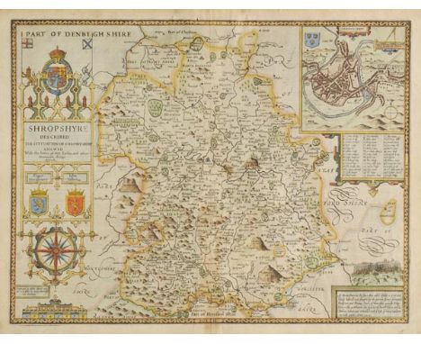
Lot 217
Shropshire. Speed (John), Shropshyre described, The Sittuation of Shrowesbury Shewed with the Armes of thos Earles and other Memorable things observed, published George Humble, circa 1627, hand coloured engraved map, large strapwork cartouche and mileage scale, inset town plan of Shrewsbury, central fold partially strengthened on verso, slight overall toning, 390 x 510 mm, English text on verso (1)
Lot 218
Staffordshire. Blaeu (Johannes), Staffordiensis Comitatus vulgo Stafford Shire, published Amsterdam, circa 1645, engraved map with contemporary hand colouring, ornate cartouche and mileage scale, 415 x 505 mm, Latin text on verso, together with another seven maps of Staffordshire, including examples by Walpoole, Archer, Morden and Saxton/Kip, some duplicates, various sizes and condition (8)
Lot 219
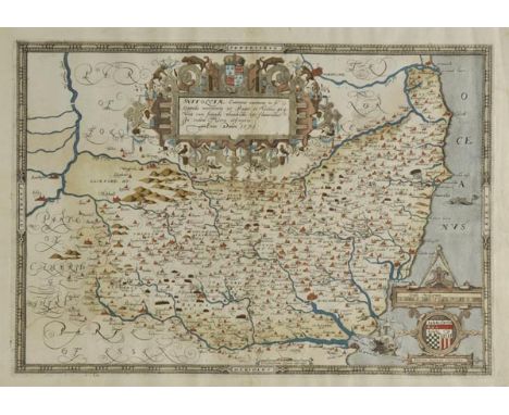
Suffolk. Saxton (Christopher), Suffolciae Comitatus continens in se Oppida Mercatoria 25 Pagos et Villas 464 una cum Singulis Hundredis & Fluminibus in eodem Vera Descriptio, circa 1579, engraved map with early hand colouring, ornate strapwork cartouche and mileage scale, central fold partially strengthened at base, slight creasing in mrgins, 340 x 480 mm With the bunch of grapes watermark. (1)
Lot 22
Martin (R. Montgomery). The Illustrated Atlas and Modern History of the World, published J.F.Tallis, circa 1857, uncoloured double page map of Liverpool, decorative title page, two comparison plates, seventy-eight (of 80), engraved maps with contemporary outline colouring (lacking Venezuela and Peru & Bolivia), a few maps with short marginal closed tears, some marginal spotting and finger soiling, a few maps trimmed with slight loss, descriptive text for Ireland with long closed tear, text for Jamaica frayed and creased, hinges and joints weak, contemporary half calf gilt, worn and frayed, folio Sold as a collection of maps, not subject to return. (1)
-
109182 item(s)/page