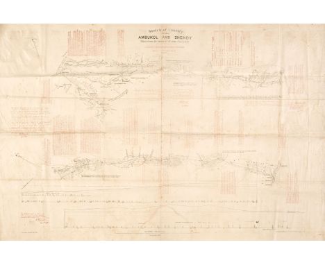

Sudan. Fowler (John, surveyor), Sketch of the Country between Ambukol and Shendy, Taken from the Survey of Mr John Fowler C. E. to which is added Descriptive Notes of the Route, Intelligence Branch, War Office, May 1884, lithographic linear map, printed in red and black on linen, some staining, old folds, 680 x 1000 mm, together with Wyld (James). Map of the Nile District between Assouan & Khartoom (sic), Foster Groom & Co. 1896, colour lithographic map, sectionalised and laid on linen, inset maps of the Red Sea and the environs of Suakim, some splits along old folds, with slight loss, 880 x 600 mm, contemporary cloth boards with publisher's label to the upper siding, some staining and slight wear to the extremitiesQTY: (2)NOTE:In the lower right corner of the map is a printed note. The Information given in red on this map is quite correct and is obtained from the studies of the Soudan Railway Survey of 1872 of which I was second in charge. W. Whitworth Sept. 10th 1884. There is a later state of this map (held by the National Library of Australia), with an addition to the title which states Revised from Sketches and Information furnished by Officers during the Campaign of 1884 - 1885. This would coincide with the siege of Khartoum and the death of General Gordon. Gordon arrived at Khartoum on 18 February 1884 and the siege took place between the 13 March 1884 and the 26 January 1885. The Mahdists hearing news of an approaching British relief column, stormed the garrison slaughtering the defenders to the last man, as well as 4,000 of the town's male inhabitants. Many of the surviving women and children were enslaved by the victorious Mahdists. Advance elements of the relief expedition arrived within sight of Khartoum two days after it fell. After discovering that they were too late, the surviving British and Egyptian troops withdrew. It is therefore possible that this map - designed for portability - was used by British officers in the relief column.
We found 109182 price guide item(s) matching your search
There are 109182 lots that match your search criteria. Subscribe now to get instant access to the full price guide service.
Click here to subscribe- List
- Grid
-
109182 item(s)/page

Cary (John). Cary's New and Correct English Atlas: Being a new Set of County maps from Actual Surveys..., 1793, frontispiece of a 'note' with an advertisement printed on the verso, title page, dedication and contents list, 47 (complete as list) engraved maps with contemporary outline colouring, each with tissue guard and a page of descriptive text, occasional toning, the map of Cheshire with later pencil reticulation, list of junctions and towns bound at rear, contemporary calf, re-backed, worn with corners repaired, 4to QTY: (1)NOTE:Chubb. CCLXIII.
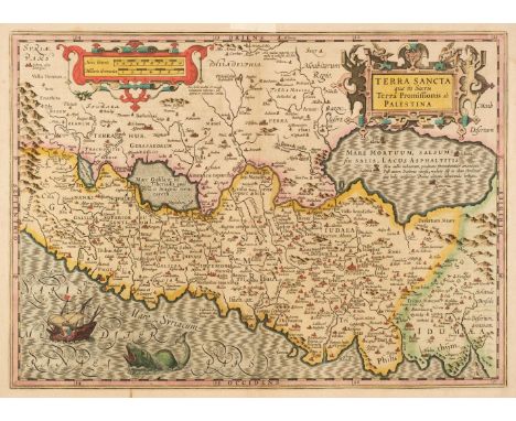
Holy Land. Hondius (Jodocus & Mercator Gerard). Terra Sancta quae in Sacris Terra Promissionis ol: Palestina, Amsterdam [1619], engraved map with early hand-colouring, large strapwork cartouche and mileage scale, central fold strengthened in the margins on the recto, 360 x 500 mm, French text on versoQTY: (1)NOTE:Eran Laor. Maps of the Holy Land, number 494. The map is based on Ortelius's earlier map of 1584 and includes the prominent vignette of Jonah being thrown to the whale, which dominates the Mediterranean Sea.
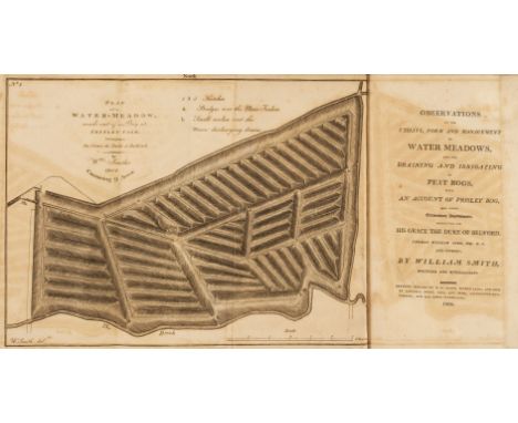
Smith (William). Observations on the Utility, Form and Management of Water Meadows, and Draining and Irrigating of Peat Bogs, with an account of Prisley Bog, and other extraordinary improvements, conducted for His Grace the Duke of Bedford, Thomas William Coke ... and others, 1st edition, Norwich: Printed by R. M. Bacon, 1806, 2 folding engraved plates, few wood engraved vignette illustrations, 6 page publisher's advertisement list at rear, some offsetting and browning, edges untrimmed, modern buckram, 8voQTY: (1)NOTE:A scarce early work by William Smith (1769-1839), who was known as 'the Father of English Geology', and famous for producing the first geological map of Britain which was published in 1815.

Martin (Martin). A Late Voyage to St. Kilda, the remotest of all the Hebrides, or Western Isles of Scotland. With a history of the island, natural, moral, and topographical. Wherein is an account of their customs, religion, fish, fowl, &c. As also a relation of a late impostor there, pretended to be sent by St. John Baptist, 1st edition, London: D. Brown, and T. Goodwin, 1698, half-title, engraved folding map, lacking the plate, publisher's advertisement leaf at rear, small ink notations in an early hand to front pastedown, contemporary Cambridge panelled speckled calf gilt, portion at foot of upper cover worn and showing, rubbed, 8voQTY: (1)NOTE:Wing M847.

Snow (William Parker). Voyage of the Prince Albert in Search of Sir John Franklin: A narrative of every-day life in the Arctic Seas, 1st edition, London: Longman, Brown, Green and Longmans, 1851, additional colour lithograph title, 3 colour lithograph plates, folding map at rear, a little slight marginal toning, all edges gilt, modern brown half calf, spine with maroon and black labels, 8voQTY: (1)NOTE:Sabin 85560.

Cornwall. Bowyer (Dan). Cornwall, published for British Railways, printed by N. Lloyd and Co. Ltd. circa 1950, large 'quad-royal' colour lithographic poster in the form of a pictorial map, small areas of old tape staining to the margins, but not affecting the printed image, slight creasing, 970 x 1220 mmQTY: (1)

Wilson (William). The Post Chaise Companion: or, Traveller's Directory through Ireland..., 3rd edition, Dublin: printed by J. & J. H. Fleming, 1803, folding map slightly torn & repaired, engraved frontispiece & 4 plates, later inscription to the front endpaper, some light toning throughout, later half calf with contemporary red calf spine label, 8vo, together with:Skrine (Henry), A General Account of all the Rivers of not in Great Britain:..., London: printed for T. Bensley, 1801, 17 maps to the rear, hole to the bottom right margin of the frontispiece, later endpapers, some light spotting & toning, later gilt decorated green full calf, boards & spine slightly rubbed & marked, 8vo, plusCarew (Richard), The Survey of Cornwall. and an epistle concerning the excellencies of the English tongue, new edition, London: printed for B. Law, 1769, tape to the hinges of the front endpaper through to the 'list of subscribers', black tape to the front gutter, some light toning & spotting, contemporary full mottled calf, hinges cracked, boards & spine slightly rubbed with some minor loss, 4to, and other mostly 19th & early 20th century topography & Kent reference & related, some leather bindings, mostly original cloth, some pamphlets, some odd volumes & duplicate copies, G/VG, 8vo/folioQTY: (4 shelves)

Macaulay (Kenneth). The History of St. Kilda, containing a description of this remarkable island; the manners and customs of the inhabitants; the religious and pagan antiquities there found; with many other curious and interesting particulars, 1st edition, London: T. Becket and P.A. de Hondt, 1764, half-title, engraved folding map, publisher's advertisement leaf at rear, catalogue clipping laid onto front pastedown, contemporary mottled calf gilt, rebacked with original spine relaid, rubbed, 8voQTY: (1)
Thomson (John). A New General Atlas, consisting of a series of geographical designs on various projections, exhibiting the form and component parts of the Globe; and a collection of maps and charts, delineating the natural and political divisions of the empires, kingdoms, and states in the World. Constructed from the best systematic works, and the most authentic voyages and travels. With a memoir of the progress of geography, a summary of physical geography, and a consulting index to facilitate the finding out of places, Edinburgh: Printed by George Ramsay and Company, for John Thomson and Company, Edinburgh; Baldwin, Cradock, and Joy, London; and John Cumming, Dublin, 1817, uncoloured engraved frontispiece of a comparison plate of mountains of the World, printed title page, dedication to Alexander Keith of Dunottar and Ravelston, list of maps and charts, 23 pages of introductory text and 22 pages of a consulting index, 74 engraved double-page and folding maps (complete as list), all with contemporary outline colouring, slight off-setting, staining and spotting, some creasing, a few maps frayed at the margins, Southern Part of Ireland, torn and frayed with slight loss, last four maps detached with the maps of 'New Holland and the Asiatic States' and the 'Chart of the Northern Passage between Asia and America' damp stained and frayed with some loss, each map with a small contemporary paper numeral pasted to the upper right corner, contemporary half calf gilt, scarred, frayed and heavily worn, rear board detached, folio (555 x 435 mm) QTY: (1)NOTE:The largest atlas published in Scotland at the time, Thomson's atlas is distinguished by its map of Europe in four sheets, the several sheets devoted to the major islands of the West Indies, as well as fine detailed maps of the Arabian peninsula, Japan and Korea

Blaeu. (Johannes). Lincolnia Comitatus Anglis Lincoln-Shire, Amsterdam, circa 1645, engraved map with bright contemporary outline colouring, 420 x 505 mm, Dutch text on verso, together with Leicestrensis Comitatus Leicester Shire, Amsterdam circa 1648, engraved map with contemporary outline colouring, 385 x 500 mm, Latin text on verso, with Morden (Robert), The Smaller Islands in the British Ocean, circa 1695, uncoloured engraved map with seven inset maps of islands, 360 x 425 mm, plus The East Riding Of Yorkshire, circa 1695, hand-coloured engraved map, 360 x 430 mmQTY: (4)

White (Gilbert). A Naturalist's Calendar, with observations in various branches of natural history, 1st edition, London: B. and J. White, 1795, hand-coloured plate, armorial bookplate of W. H. Mullens to front pastedown, a few spots, top edge gilt, remainder untrimmed, late 19th-century green half morocco gilt, lightly rubbed, 8vo, together with:White (Gilbert). The Natural History of Selborne, 2 volumes, new edition, London: C. and J. Rivington, 1825, engraved frontispiece to volume 1, 2 plates in volume 2 (one lithograph, one hand-coloured engraving), bookplate of John Fairweather to front pastedown, early 20th-century half calf gilt, 8vo, withGilpin (William). Remarks on Forest Scenery, and other woodland views, 3 books in 2 volumes, 1st edition, London: R. Blamire, 1791, 31 plates (including many tinted aquatints), folding map, errata leaf at rear of volume 1, modern speckled half calf gilt, 8vo, with Yarrell's A History of British Birds (3 volumes plus supplement, 1843), White's The Natural History and Antiquities of Selbourne (1813), Mudie's The Feathered Tribes of the British Islands (2nd edition, 2 volumes) and A New System of the Natural History of Birds, printed for Peter Hill (1792)QTY: (13)

Americas. Tirion (Isaak), Nieuwe Kaart van America Uitgegeven te Amsterdam, circa 1750, engraved map with contemporary outline colouring, 280 x 320 mm, together with another eleven state and regional maps of North America, including examples by or after Mitchell, A. J. Johnson, Brué and Dower, various sizes, good conditionQTY: (12)

* World. Dampier (William), Nouvelle Carte du Monde Suivant l'idee de Mercator ou est marquee la Toure que le Cap. Cowley tint.pour en faire le tour, Paul Marret, Amsterdam, circa 1705, uncoloured engraved map on Mercator's projection, inset map of the North pole, insular California, 160 x 285 mm, mounted, framed and glazedQTY: (1)
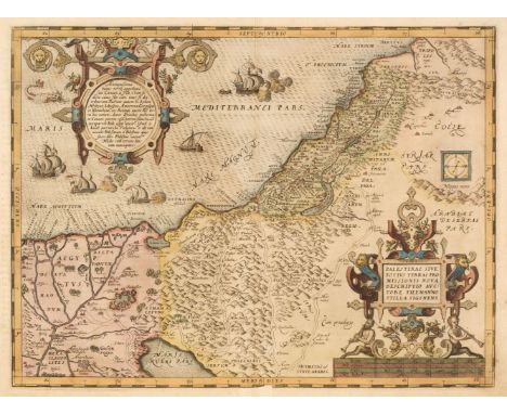
Holy Land. Ortelius (Abraham), Palestinae sive Totius Terrae Promissionis nova Descriptio Auctore Tilemanno Stella Sigenens [1580 - 89], hand-coloured engraved map, large strapwork cartouche and mileage scale, very slight staining and dust soiling, central fold strengthened on the recto in the lower margin, 345 x 465 mm, German text on versoQTY: (1)NOTE:Marcel van den Broecke. Ortelius Atlas Maps, number 171. E. Laor. Maps of the Holy Land, number 540 B.
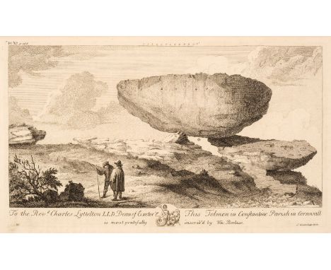
Borlase (William). Observations on the Antiquities, Historical and Monumental, of the County of Cornwall. Consisting of several essays on the first inhabitants, druid-superstition, customs, and remains of the most remote antiquity, 1st edition, Oxford: W. Jackson, 1754, engraved map, 23 engraved plates, hinges repaired, contemporary Cambridge panelled calf gilt, rebacked with original spine relaid, corners repaired, upper joint cracked (with portion separated), rubbed, folioQTY: (1)

Leicestershire. Speed (John), Leicester both Countye and Citie Described, The Honorable Famylies that have had the titles of Earls thereof. With other accidents therein observed, Henry Overton, circa 1707, uncoloured engraved map, inset city plan of Leicester, slight staining to the upper margin, 380 x 505 mm, no text on verso, together with another 46 maps of Leicestershire and Rutland, including examples by or after, Smith, Cary, Fullarton, Cruchley, Archer, Moule, Hall, Pigot/Slater, Neele, Cole & Roper, Lewis, Taylor/Blome. Kitchin, Moll, Ellis, Morden, Seller, Seller/Grose, Rocque, Dower, J & C Walker, Dawson, Virtue & Co., Collins, Philip & Son and Weller, occasional duplicates, various sizes and conditionQTY: (47)
Shaw (Stebbing). The History and Antiquities of Staffordshire, compiled from the manuscripts of Huntbach, Loxdale, Bishop Lyttelton, and other collections of Dr. Wilkes. The Rev. T. Feilde, &c. &c. including Erdeswick's survey of the county; and the approved parts of Dr. Plot's Natural History. The whole brought down to the present time..., 2 volumes [volume 1 and volume 2 part 1 (all published)], London: printed by and for J. Nichols, 1798-1801, half-titles discarded, engraved folding county map and folding plan of Wolverhampton, 82 engraved and aquatint plates (one double-page), few folding genealogical tables, engraved illustrations, occasional neatly repaired short closed tears to few plates, some offsetting and browning mostly to text, some light scattered spotting, edges untrimmed, front pastedown of first volume with annotation 'This copy came from the library of Pype Wolferson at Statfold Hall nr. Tamworth who collaborated with Shaw in the compilation of this work. The manuscripts used are in the Leicestershire or Leicester Public Library, JTK' and with the bookplate of J. Timothy Kenrick, contemporary half vellum with contrasting morocco labels to spines (some loss to volume 2 number label), first volume repaired at head, folio (50.8 x 30.5 cm)QTY: (2)NOTE:Samuel Pipe (1751-1820) inherited the Wolferstan estates from his grandfather, Stanford Wolferstan (d.1772) and adopted the surname Pipe-Wolferstan in 1776. Samuel Pipe-Wolferstan was a distinguished antiquary who provided considerable assistance to the Reverend Stebbing Shaw for his History and Antiquities of Staffordshire and he was also a friend of William Hamper, the Birmingham antiquary.Upcott pp. 1176-1185.

* Northern Europe & Poland. Munster (Sebastian), Schlesien nach aller gelegenheit in Stetten..., Henry Petri, Basel, [1574], hand-coloured woodcut map, 265 x 340 mm, mounted in a double-aperture mount with another uncoloured example, framed and glazed, together with Cluver (P.) Svevia Quae Cis Coda Num Suit Sinum Antiqua Descriptio, Paris, circa 1620 - 1711, four hand-coloured examples (different editions) of the map, displayed in a multi-aperture mount, together with Bertius (Pieter). Sueviae, circa 1661, uncoloured engraved map, originally published in Cluver's 'Introductionis in Universam Geographiam', 125 x 125 mm, framed and glazed, with Mercator (G. & Hondius H.). Lusatia Superior..., Amsterdam, circa 1620, engraved map with contemporary outline colouring, displayed in a double-aperture mount with another uncoloured example, each 390 x 500 mm, framed and glazed, plus Zatta (Antonio). Li Palatinati di Wilna, Troki, Inflant coi Ducati di Kurlandia E Smudz..., Venice, 1781, engraved map with contemporary outline colouring, displayed in a double-aperture mount with another uncoloured example, each 415 x 320 mm, framed and glazed, and Moll (Herman). Tabula Geographica exhibens districtum inter Weichselmundam et promontorium Reesehóest..., portus Dantiscanus, circa 1680, hand-coloured engraved map of the port of Gdansk, displayed in a double-aperture mount with another uncoloured and slightly later example by Francois de Lepine, each 275 x 340 mm, framed and glazed, with another eight maps similar (in five frames) with examples by or after Bowen, Gibson, Tirion and Homann, various sizes, good conditionQTY: (21 maps in 10 frames)
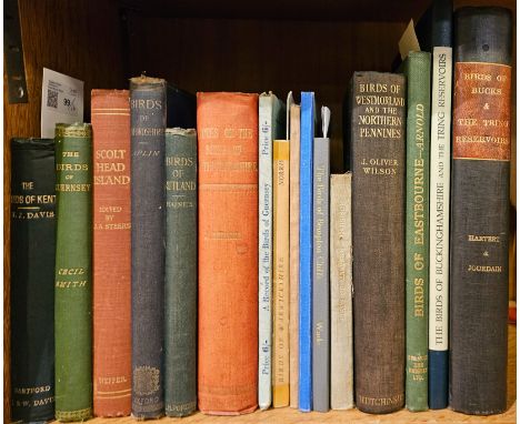
Davis (William J.). The Birds of Kent, 1st edition, Dartford: printed and published by J & W. Davis, 1907, photographic frontispiece, folding map (repaired with sellotape without loss), original dark green cloth gilt, a little rubbed, together withSmith (Cecil). The Birds of Guernsey and the neighbouring islands Alderney, Sark, Jethou, Herm; being a small contribution to the ornithology to the Channel Islands, 1st edition, London: R. H. Porter, 1879, armorial bookplate of Pershouse to front pastedown, and later bookplate of Owen Wynne below, original green cloth gilt, some marks, plus Steers (J. A.). Scolt Head Island, the story of its origin: the plant and animal life of the dunes and marshes, 1st edition, Cambridge: Norfolk & Norwich Naturalist's Society by W. Heffer & Sons, 1934, folding maps, monochrome plates, original rust brown cloth, lightly rubbed, and other ornithological county histories including O. V. Aplin, The bIrds of Oxfordhsire, 1889, C. Reginal Haines, Notes on the Birds of Rutland, 1907, E. C. Arnold, Birds of Eastbourne, 1936, J. Whitaker, Notes on the bIrds of Nottinghamshire, 1907, Hartert and Jourdain, The Birds of Buckinghamshire and the Tring Reservoirs, 1920 (rebound), 2 copies, including one interleaved with manuscript notes, J. Oliver Wilson, Birds of Westmorland and the Northern Pennines, 1933, Henry Le Marchant Brock, A record of the Birds of Guernsey, 1950, C. A. Norris, Notes on the bIrds of Warwickshire, 1947, M. P. price, Notes on the Vertebrate Fauna of Harrow, 1904, M. B. Horan, the Birds and Mammals of Bury, 1949 etc., mostly original cloth, mainly 8voQTY: (16)
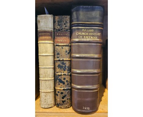
Euripides. Euripidis quae extant omnia..., 2 volumes in one, Cambridge: Johannis Hayes, 1694, 2 engraved portrait plates, some browning and spotting, contemporary vellum, rebacked, folio, together with:Diodorus (Siculus). The Historical Library of Diodorus the Sicilian. In fifteen books. The first five, contain the antiquities of Egypt, Asia, Africa, Greece, the islands, and Europe. The last ten, an historical account of the affairs of the Persians, Grecians..., London: Awnsham and John Churchil, 1700, one folding engraved map only of two (missing map provided in facsimile), one single-page engraved map, some browning and spotting, armorial bookplate of Lord Sinclair to upper pastedown and early ownership signature Humphry Hardwick dated 1702, contemporary panelled specked calf, rebacked, folio,Fuller (Thomas). The Church-History of Britain; from the Birth of Jesus Christ, until the Year M. DC. XLVIII., 1st edition, London: John Williams, 1655, general title trimmed to ruled border and lined to verso, folding engraved plan (repaired), double-page and single-page armorial plate, text bound out of sequence throughout volume, modern dark brown sheep, folio QTY: (3)
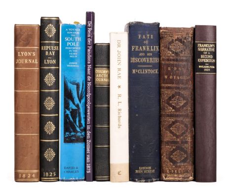
Lyon (G.F). The Private Journal of Captain G. F. Lyon, of H.M.S. Hecla, during the recent voyage of discovery under Captain Parry, 1st edition, London: John Murray, 1824, engraved frontispiece, 6 engraved plates, folding map, a few light spots, contemporary half calf, rebacked, spine lettered in gilt, rubbed, 8vo, together with:A Brief Narrative of an Unsuccessful Attempt to reach Repulse Bay, through Sir Thomas Rowe's “Welcome" in His Majesty's Ship Griper, 1st edition, London: John Murray, 1825, folding map, 7 engraved plates, lightly spotted, untrimmed, endpapers renewed, modern blue crushed half morocco gilt, 8vo, plusFranklin (John). Narrative of a Second Expedition to the Shores of The Polar Sea, in the years 1825, 1826, and 1827, 1st US edition, Philadelphia: Carey, Lea, and Carey, 1828, folding map frontispiece, 4 pp. adverts at front, toned and spotted, modern burgundy cloth-backed boards, spine lettered in gilt, 8vo, with 5 other works related to Polar explorationQTY: (8)

Beeverell (James). Les Delices de la Grand Bretagne & de Irlande..., volume 4 (only) Pierre Van Der Aa, Leiden, 1707, title printed in red and black, additional decorative double-page half-title, 2 double-page engraved maps and 32 double-page engraved topographical views of London and its environs, bookplate of Nathan of Churt, 19th-century calf with contrasting morocco gilt label to spine, a little worn, 8vo, together with Tunnicliff (William). [A Topographical Survey of the Counties of Stafford, Cheshire and Lancaster] circa 1787, lacking title page, three uncoloured engraved folding maps, some offsetting, contemporary half calf, upper board detached, rubbed and worn, 8vo, with Hall (Sidney). [A Travelling County Atlas with all the Coach and Rail Roads..., 1842], lacking title page, 54 uncoloured double-page engraved maps, some dust soiling throughout, contemporary half calf upper board detached, lacking spine and rear board, rubbed and worn, 8vo, and Norden (John). Speculum Britanniae: An Historical and Chorographical Description of Middlesex and Hertfordshire..., Daniel Brown Senior & Junior and James Woodman, 1723, title printed in red and black, two further title pages and an additional decorative half-title, one (only) uncoloured engraved map of Middlesex, map toned overall, some spotting and staining throughout, bookplates of Alfred Heales and E. Donald Smart, text block detached, contemporary blind-stamped calf, boards detached, rubbed and worn, slim 8vo, plus another 19 topographical volumes, mostly defective, including examples by or after Cooke, Seller, Patterson, Knight, Harwood, Nightingale and Capper, various sizes and conditionQTY: (23)NOTE:Sold as a collection of maps and prints, not subject to return.

Sydney. Parish of Hunters Hill, County of Cumberland, Metropolitan & Parramatta Land Districts, Eastern Division, N. S. W. Compiled, Drawn and Printed at the Department of Lands, Sydney, Oct. 1907, colour photolithographic map, laid on linen, old folds, heavily stained, creased, spotted and dust soiled, some marginal fraying. 740 x 815 mmQTY: (1)

Mosley (Oswald). The Natural History of Tutbury, together with the fauna and the flora of the district surrounding Tutbury and Burton-on-Trent, 1st edition, London: John Van Voorst, 1863, half-title, 9 lithographic plates (including frontispiece), small Royal Institution blindstamp to title, original brown cloth gilt, spine reinforced, 8vo, together with:Garner (Robert). The Natural History of the County of Stafford; comprising its geology, zoology, botany, and meteorology: also its antiquities, topography, manufacturers, etc, 1st edition, London: John Van Voorst, 1844, etched frontispiece and illustrations, Royal Geological Society of Penzance ink stamps (including to title), original blindstamped brown cloth gilt, some fading, 8vo, withMacPherson (H. A and William Duckworth). The Birds of Cumberland, critically studied, including some notes on the Birds of Westmoreland, 1st edition, Carlisle: Chas. Thurnam & Sons, 1886, inscribed by the author to front blank, frontispiece by Keulemans, folding colour map, modern red half morocco gilt, 8vo, plusSterland (W.J). The Birds of Sherwood Forest. With notes on their habits, nesting, migrations, &c, 1st edition, London: L. Reeve & Co, 1869, 3 hand-coloured lithographs, 1 black and white plate, neat near-contemporary ownership inscription to front blank, a few spots, contemporary red prize calf gilt, lightly rubbed, 8voQTY: (4)
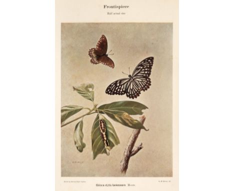
Woodhouse (L.G.O., and Henry, G.M.R.). The Butterfly Fauna of Ceylon, 1st edition, Colombo: Ceylon Government Press, 1942, signed by the author (Woodhouse) to front pastedown, colour frontispiece, map, 36 colour and 13 black & white plates, with captioned tissue guards, some pale spotting to plate I and to frontispiece margins, front free endpaper with later ownership signature, loosely inserted ink manuscript letter from Woodhouse, and 2pp. pencilled errata signed by Woodhouse, original cloth gilt, extremities lightly bumped, small mark to front cover fore edge, 4to, together with: Woodhouse (L.G.O.), The Butterfuly Fauna of Ceylon, 2nd (abridged) edition, 1950, colour frontispiece, map printed in black & red, 36 colour and 12 black & white (printed both sides) plates, few light spots to letterpress, endpapers renewed, 20th century quarter calf gilt, lightly rubbed, small mark to front cover, 4toQTY: (2)
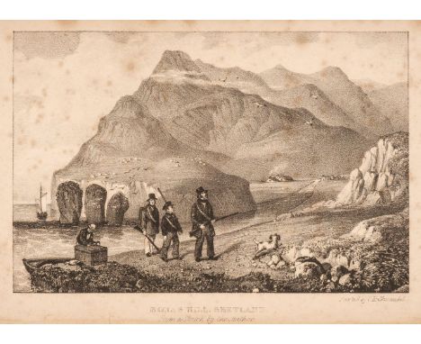
* Dunn (Robert). The Ornithologist's Guide to the Islands of Orkney and Shetland, London: printed by Richard Taylor, Red Lion Court, Fleet Street; and published by the author, 31 George Street, Hull, 1837, half-title, lithograph frontispiece, two folding engraved maps at rear, some spotting to frontispiece and title, original green cloth, with remains of paper labels to spine, rubbed and some marks, 8vo in 12's, together withBaikie (William Balfour, and Robert Heddle). Historia Naturalis Orcadensis. Zoology. Part I. Being a catalogue of the mammalia and birds hitherto observed in the Orkney Islands [all published], Edinburgh: printed by J. W. Patterson, 1848, 104pp., pale yellow chalk-glazed endpapers (front free endpaper removed), original blind-stamped green cloth, rubbed and spine with minor wear and lightly faded, 8vo, plusCrichton (A. W.). A Naturalit's Ramble to the Orcades, 1st edition, London: John van Voorst, 1866, tinted lithograph frontispiece, 132pp., 8pp publishers list at end, original green cloth gilt, rubbed and a some fraying to extreme head and foot of spine, small 8vo, and three others: Daniel Gorrie, Summers and Winters in the Orkneys, London: Simkin, Marshall & Co., [1869], folding map in pocket at rear, original purple cloth, a little rubbed and faded, James Frea, The Present State of the Orkney Islands considered, and an account of the new method of fishing of the coast of Shetland, published in 1775, Edinburgh: William Brown, 1884, partly untrimmed, original pale green cloth with paper label to spine, a little rubbed and spine label somewhat discoloured, 8vo, limited edition 98/162, and M. M. Charleson (editor), Orcadian Papers: being selections of the proceedings of the Orkney Natural History Society, form 1887 to 1904, Stromness: printed for the Society by William Rendall, 1905, monochrome illustrations, original cloth, rubbed and some soiling, frayed to head of upper joint, 8vo QTY: (6)

Martin (Martin). A Description of the Western Islands of Scotland, 2nd edition, London: A. Bell, 1716, folding engraved map, folding engraved plate, 20th-century armorial bookplate of John Clerk Brodie to front pastedown, contemporary sprinkled calf, rebacked with original spine relaid (endpapers renewed), later red morocco title label, spine toned, 8voQTY: (1)NOTE:Goldsmiths 5286.
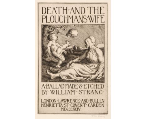
Strang (William). Death and the Ploughmans Wife, London: Lawrence and Bullen, 1894, etched title and 11 plates, each signed in pencil to lower margin, bookplate of Loyse Knowles to upper pastedown, top edge gilt, remainder untrimmed, original morocco-backed cloth, spine and extremities rubbed, slight dust soiling to covers, folio (limited edition 14/110), together with:Strang (William). The Earth Fiend. A Ballad made & etched by William Strang, London: Elkin Mathews and John Lane, 1892, etched title and 10 plates, top edge gilt, remainder untrimmed, original cloth, few marks, folio (limited signed edition 48/150), Bone (Gertrude). Of The Western Isles, London: T. N. Foulis, 1925, woodcut frontispiece and illustrations by Stephen Bone, map endpapers, edges untrimmed, original vellum-backed printed boards, 8vo (limited signed edition 54/150),Richardson (Maimie A.). Stirling Castle and other Poems, London: Alexander Maclehouse & Co., 1934, etched frontispiece and 4 monochrome plates by Sir David Young Cameron, top edge gilt, remainder untrimmed, original cloth, folio, plus Strang (William). A Book of Giants, drawn, engraved and written by William Strang, London: Unicorn Press, 1898, illustrations throughout, edges untrimmed, original pictorial cloth, small 4toQTY: (5)

Gill (Leslie MacDonald). The London Season, published in The Graphic, June 1st 1929, colour photolithographic allegorical map, central fold strengthened on recto, 345 x 465 mm, together with Empire Marketing Board (publishers). Highways of the Empire, circa 1930, colour printed map postcard, 100 x 145 mm, with a photographic glass slide of the same image, overall size 82 x 82 mm, plus Ceylon Tea Propaganda Board (publishers). Map of Ceylon showing her Tea Industry, circa 1933, small colour lithographic postcard flyer of a map of Ceylon, 130 x 85 mm, and an untitled allegorical map of North-western South America, old folds, 350 x 195 mm, plus a colour print of a 'Study for a Chancel, L. MacDonald Gill, Architect,' 220 x 135 mm, with The Studio, July - December 1944, volume 128 (2 copies), December 1944 and May 1925, including Gill's illustrated article 'Decorative Maps' and in the 1925 edition and illustrated article on Gill's pictorial maps, mixed bindings, plus Home and Country Magazine, March 1936, a periodical with a front cover of a map of England and Wales designed by MacDonald Gill (cartobibliographically unrecorded), and two London Transport Souvenir Maps circa 1980 titled 'London 1922 - In the Heat of Summer' and 'London 1928 - Country Bus Routes', large colour printed folding pictorial maps, each approximately 725 x 895 mm, each with publisher's colour printed stiff card wrappers, with Farjeon (Eleanor). Nursery Rymes of London Town, The Citadel Press, 1947, additional half-title and an allegorical colour frontispiece by MacDonald Gill, publisher's cloth, wrapped in clear library cover, ex-library with card pocket stuck to rear pastedown, 8voQTY: (14)
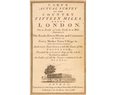
Cary (John). Cary's Actual Survey of the Country Fifteen Miles round London..., 1st edition, 1786, engraved calligraphic decorative title, table of explanation, engraved double-page 'general' map of the environs of London and fifty (complete) engraved maps, all with contemporary outline colouring, index bound at rear, numerous near-contemporary manuscript annotations to the verso of several of the maps, slight offsetting throughout, three-page manuscript letter from George Cary (John Cary's grandson), dated 1875, bound in after the front blank, late 19th-century manuscript annotations to the front endpapers listing enclosures and commons, later endpapers, 20th-century gilt morocco boards and spine with gilt turn-ins, 8voQTY: (1)
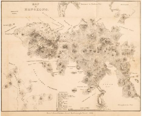
Hall (William Hutcheson & William Dallas Bernard). Narrative of the Voyages and Services of the Nemesis from 1840 to 1843, and of the combined Naval and Military Operations in China: comprising a complete account of the Colony of Hong-Kong, and remarks on the character & habits of the Chinese, 2nd edition, London: Henry Colburn, 1845, 4 folding maps, 3 engraved plates only (of 4, lacking plate of the Nemesis), advertisements at end, some light spotting and toning, previous owner signature of Henry William Jones at head of first preface leaf, inscription to frontispiece verso, original green blindstamped cloth, rebacked, some light edge wear, 8vo, together with The Nemesis in China, comprising a History of the Late War in that Country; with an account of the Colony of Hong-Kong, 4th edition, with a new introduction, London: Henry Colburn, 1848, 3 engraved plates, 1 folding map only (of 4), advertisements at rear, some water stains and soiling to plates, some light spotting, previous owner inscription to frontispiece verso, bookplate, original green cloth, rebacked with original spine relaid, a few stains, 8vo, plus volume II only (of 2) of Travels in Kamtchatka and Siberis; with a narrative of a residence in China, by Peter Dobell, 1830QTY: (3)NOTE:Sold with all faults not subject to return.
Pennant (Thomas). A Journey from London to the Isle of Wight, 2 volumes in one, London: Printed at the Oriental Press, by Wilson & Co. for Edward Harding, 1801, half-titles, frontispiece to each volume of folding engraved maps with contemporary outline colouring, preface, advertisements and index, 47 uncoloured engraved plates, including one folding (Brighton Pavilion), Plate of William Chillingworth misbound, some spotting throughout, bookplate of N. Webb Esqre. 24 Portland Place, contemporary half calf gilt, bumped and a little worn, spines faded and stained, 4to, together with Gastineau (Henry). Wales Illustrated, in a Series of Views, London: Jones & Co., 1830, two engraved vignette titles, 200 engraved views on 100 plates, tissue guards, occasional light spotting, contemporary half calf with gilt decorated spine, bumped and a little frayed at extremities, 4to, with Gathorne-Hardy (The Hon. A. E.). Autumns in Argyle-Shire with Rod and Gun, Longmans, Green and Co. 1900, additional half-title, dedication, preface and index, 8 uncoloured gravure plates after Archibald Thorburn, very slight spotting, modern half burgundy morocco gilt, 8vo, plus Lumsden (James & Son, publishers). Lumsden & Son's Steam Boat Companion and Stranger's Guide to the Western Islands & Highlands of Scotland..., 1828, letterpress title, 24 uncoloured engraved views on 6 plates, 3 uncoloured engraved folding maps at rear, contemporary burgundy morocco with ornate gilt title to the upper siding and spine, bumped and a little worn, upright 8vo, and Lumisden (Andrew). Remarks on the Antiquities of Rome and its Environs: Being a Classical and Topographical Survey of the Ruins of that Celebrated City, 1st edition, W. Bulmer & Co. 1797, portrait frontispiece, large engraved folding map of the environs of Rome, with a short handling tear, and 10 further engraved maps and plates (including 3 folding) occasional offsetting and spotting, contemporary speckled calf, re-backed, bumped and a little worn, 4toQTY: (6)
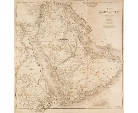
Arabia. Chesney (Lieut. Colonel), A Map of Arabia and Syria Laid down Chiefly from Original Surveys Under the Superintendence of Lieut. Colonel Chesney and drawn by W. H. Plate..., Longman, Brown & Co. 1849, uncoloured map engraved by J & C Walker, laid on silk, old folds, slight staining, 685 x 660 mm, together with, Map of the Countries Situated between the Rivers Nile and Indus; serving as an Index to the Work on the Expedition for the Survey of the Euphrates and Tigris Drawn from Materials furnished by Lieut. Colonel Chesney..., Longman & Co. 1850, map with contemporary outline colouring, engraved by J & C Walker, laid on silk, old folds, slight worming to the printed surface, slight staining, 630 x 760 mm, contained in a contemporary morocco slipcase with gilt decorated spine and marbled paper sidings and 'Estcourt Library' label to the upper coverQTY: (2)NOTE:A rare pair of maps, originally published in Chesney's "The Expedition for the Survey of the Rivers Euphrates and Tigris, carried on by order of the British Government, in the Years 1835, 1836, and 1837; preceded by geographical and historical notices of the regions situated between the rivers Nile and Indus", published by Longman, Brown, Green and Longmans, 1850. The book is considered a landmark text on the Near and Middle East, executed by an extraordinary explorer who has been called the “founder of the overland route to India” (ODNB). The book was originally designed to be published in four volumes, but only the first two were ever released, together with a map slip case containing 13 maps. This example retains the original slipcase.The Euphrates expedition was led by a British army officer, Colonel Francis Rawson Chesney. The main objective was to establish a route “between the Mediterranean Sea and His Majesty’s possessions in the East Indies by means of a steam communication of the river Euphrates”. Finding a shorter route to India was the hot topic of the time. The East India Company particularly, needed a solution to cut down the travel time between England and India. Chesney was involved in initial surveys in Egypt and the Middle East in the late 1820s where he had investigated the possibility of passage to India via the Red Sea and in 1829, submitted a report advocating the construction of the Suez Canal. He also brought to attention the feasibility of steam communication with India through the Euphrates. King William IV himself expressed a desire that the route by the Euphrates to India should be put to a practical test. The main task involved determining the depth, current and state of the river and this wealth of data was used in the compilation of detailed charts of the region’s waterways from the Mediterranean to the Persian Gulf. The Euphrates project was shelved and the shorter route to India was eventually established in late 1869 via the Suez Canal. Nevertheless, Chesney’s survey proved an invaluable source of information on the region’s hydrography.

Nelson (T. N.). The Birds of Yorkshire, 2 volumes, 1st edition, London: A. Brown, 1907, colour frontispieces, illustrated colour titles, further black and white illustrations (many after photographs), lightly spotted, modern red half morocco gilt, 8vo, together with:Glegg (William E.). A History of the Birds of Essex, 1st edition, London: H.F. & G. Witherby, 1929, 20 plates, folding map, top edge gilt, lightly spotted, modern red half morocco gilt, 8vo, withBucknill (John A.). The Birds of Surrey, 1st edition, London: R.H. Porter, 1900, monochrome illustrations throughout, modern red half morocco gilt, 8vo, with 6 other ornithological works, all bound in red half morocco, including Smith's Birds of Wiltshire (1887), Glegg's Birds of Middlesex (1935) and Balston's Birds of Kent (1907)QTY: (10)
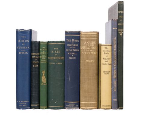
Borrer (William). The Birds of Sussex, 1st edition, London: R. H. Porter, 1891, 6 hand-coloured lithograph plates, folding map, bookplate of Sir Giles Loder to front pastedown, inner hinges partly cracked, original blue cloth gilt, very lightly rubbed to extremities (a good copy), together withKnox (A. E.). Ornithological Rambles in Sussex; with a systematic catalogue of the birds of that county, and remarks on their local distribution, 3rd edition, London: John van Voorst, 1855, 4 tinted lithograph plates, some light spotting, original green cloth gilt, a little rubbed to extremities, plusKennedy (Alexander W. M. Clark). The Birds of Berkshire and Buckinghamshire: a contribution to the natural history of the two counties, 1st edition, Eton: Ingalton and Drake, London: Simpkin, Marshall and Company, 1868, 4 hand-tinted photographic plates, list of subscribers at end, original green cloth gilt, a little rubbed, and other county histories, including Cecil Smith, The Birds of Somersetshire, 1869, J. E. Kelsall and Philip W. Munn, The BIrds of Hampshire and the Isle of White, 1905, Frank Morey, editor, A Guide to the Natural History of the Isle of White, 1909, A. Mayall, Birds and Bird's Nest of Bromsgrove, 1911, Sanley Lewis, The Breeding Birds of Somerset and their Eggs, W. L. Mellersh, A Treatise on the Birds of Gloucestershire, 1902, and a bound extract on the birds of Sussex from the Victoria History of the county of Sussex by J. G. Millais, 1906, with autograph presentation inscription by Millais to first leaf of text 'A contribution to the Victoria History of the County of Sussex! by J. E. Millais. 1906. with the author's best wishes. Feb.3rd 1906', all original cloth, 8vo (except final volume bound in contemporary green cloth, folio QTY: (10)


The Scenery and Antiquities of Ireland by J. Stirling Coyne and illustrated from drawings by W.H. Bartlett published George Virtue (c.1840s) in 2 volumes with engraved titles, printed titles, map and full-page steel engraved plates with tissue guards, bound in publisher's embossed cloth with gilt decorations and lettering (2)

The Christian’s Complete Family Bible or, Universal Library of Devine Knowledge...with Old & New Testaments and with the Apocrypha, at large etc forming a Complete Body of Christian Divinity embellished with 40 engravings (including Map of the Holy Land), printed by J. Nuttall 1803 folio bound in full leather


![[Geneva Bible] The Bible That is The Holy Scriptures contained in the Old and New Testament, Translated according to the Ebre](https://cdn.globalauctionplatform.com/83bfa3bd-f2d7-497d-a889-b07300fabb51/ec22298f-782d-46bc-bb87-b08f00c6363e/468x382.jpg)
[Geneva Bible] The Bible That is The Holy Scriptures contained in the Old and New Testament, Translated according to the Ebrew and Greeke, and conferred with the best translations in diuers languages, Imprinted by Robert Barnes 1615 with an engraved title page to each part, a map, plan, several wood-engravings and decorated initials and double-page map rear, rebound in half leather with cloth boards and gilt spine (lacking part of engraved title, damage to few pages & some staining towards rear).

Patrick Moore's Moon map celebrating the 40th anniversary of Apollo 11 New and signed by Patrick Moore A3 sized. Good condition. All autographs are genuine hand signed and come with a Certificate of Authenticity. We combine postage on multiple winning lots and can ship worldwide. UK postage from £5.99, EU from £7.99, Rest of World from £10.


ARGYLL & SUTHERLAND HIGHLANDER'S DRESS SPORRAN LATE 19TH / EARLY 20TH CENTURY the brass cantle over a badger's head and six tassels suspended from brass mounts embossed with thistles, the oxblood leather back with single pocket, alongside an early 20th century photograph of an A&SH officer, a pair of spurs, extracts from the service record of Lt. Col. J.S. Smith M.C. R.E., and further extracts, also a WWI period map of Galipoli (Sheet 2)Note: The photograph is Captain Graham Skelton-Smith, the second generation to wear the dress sporran and the second to serve in the A&S Highlanders. Lt. Col. James S. Smith was his father who served first in the A.&S.H. and also in the Royal Engineers. The map and written documents are related to his time in the R.E. during the Gallipoli campaign. the cantle 14.5cm wide


-
109182 item(s)/page